
Search Constraints
You searched for:
Publisher
Главное Управление Геодезии и Картографии при СНК СССР
Remove constraint Publisher: Главное Управление Геодезии и Картографии при СНК СССР
Search Results
-
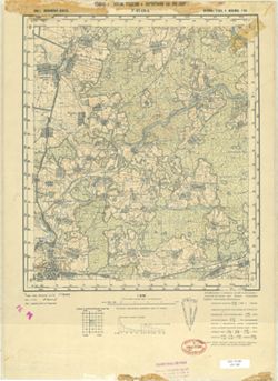
- Description:
- 1939
- Subject:
- Topical Subject: Soviet Union, Geographic Subject: Novoye Titovo, and Topical Subject: Maps
- Publisher:
- Главное Управление Геодезии и Картографии при СНК СССР
- Language:
- Russian
- Date Created:
- 1941
- Identifier:
- VAC9619-001595
- Genre:
- Topographic Maps and Military Maps
- Geographic Location:
- Coordinates: 55.5, 39, 55.6667, 39.25
- Related URL:
- Catalog URL: http://iucat.iu.edu/catalog/5020131 and Download GeoTIFF: https://drive.google.com/open?id=15wtPDAMzRpWlDqIsKsp-80h3KG7fUqbB
- Abstract:
- Modern area represented: Novoye Titovo, Moscow oblast, Russia
- Call Number:
- G7000 s50 .S68 sheet N-37-19-A
- Copyright Holder:
- No Copyright - United States
- Country:
- СССР (USSR)
- State/Province:
- Московская область (Moscow oblast) and РСФСР (RSFSR)
- Physical Description:
- Scale: 1:50,000
- Persistent URL:
- http://purl.dlib.indiana.edu/iudl/images/VAC9619/VAC9619-001595
- Provenance:
- Army Map Service Library, Library of Congress Geography & Map Division, OMAHA
-

- Description:
- 1940
- Subject:
- Topical Subject: Maps, Geographic Subject: Volovo, and Topical Subject: Soviet Union
- Publisher:
- Главное Управление Геодезии и Картографии при СНК СССР
- Language:
- Russian
- Date Created:
- 1941
- Identifier:
- VAC9619-001634
- Genre:
- Military Maps and Topographic Maps
- Geographic Location:
- Coordinates: 52, 37.75, 52.167, 38
- Related URL:
- Download GeoTIFF: https://drive.google.com/open?id=1Y2T-2H0oNJDMUHh9pMmjVVwqt2WaYCUg and Catalog URL: http://iucat.iu.edu/catalog/5020131
- Abstract:
- Modern area represented: Volovo, Oryol oblast, Russia
- Call Number:
- G7000 s50 .S68 sheet N-37-136-C
- Caption:
- Для служебного пользования
- City:
- Волово (Volovo)
- Copyright Holder:
- No Copyright - United States
- Country:
- СССР (USSR)
- State/Province:
- Курская область (Kursk oblast), РСФСР (RSFSR), and Орловская область (Oryol oblast)
- Physical Description:
- Scale: 1:50,000
- Persistent URL:
- http://purl.dlib.indiana.edu/iudl/images/VAC9619/VAC9619-001634
- Provenance:
- DMA Topographic Center, Army Map Service Library, OMAHA, Library of Congress Geography & Map Division
-
- Description:
- 1940
- Subject:
- Topical Subject: Maps, Geographic Subject: Vyshneye Olshanoye, and Topical Subject: Soviet Union
- Publisher:
- Главное Управление Геодезии и Картографии при СНК СССР
- Language:
- Russian
- Date Created:
- 1941
- Identifier:
- VAC9619-001633
- Genre:
- Topographic Maps and Military Maps
- Geographic Location:
- Coordinates: 52, 37.5, 52.167, 37.75
- Related URL:
- Download GeoTIFF: https://drive.google.com/open?id=1-gQWC7au61DmD7m8v6w1UAehnLXS2qrn and Catalog URL: http://iucat.iu.edu/catalog/5020131
- Abstract:
- Modern area represented: Vyshneye Olshanoye, Oryol oblast, Russia
- Call Number:
- G7000 s50 .S68 sheet N-37-136-C
- Caption:
- Для служебного пользования
- City:
- Верх. Ольшаное (Vyshneye Olshanoye)
- Copyright Holder:
- No Copyright - United States
- Country:
- СССР (USSR)
- State/Province:
- РСФСР (RSFSR), Орловская область (Oryol oblast), and Курская область (Kursk oblast)
- Physical Description:
- Scale: 1:50,000
- Persistent URL:
- http://purl.dlib.indiana.edu/iudl/images/VAC9619/VAC9619-001633
- Provenance:
- DMA Topographic Center, Army Map Service Library, OMAHA, Library of Congress Geography & Map Division
-
- Description:
- 1940
- Subject:
- Topical Subject: Soviet Union, Topical Subject: Maps, and Geographic Subject: Nikolskoye
- Publisher:
- Главное Управление Геодезии и Картографии при СНК СССР
- Language:
- Russian
- Date Created:
- 1941
- Identifier:
- VAC9619-001632
- Genre:
- Topographic Maps and Military Maps
- Geographic Location:
- Coordinates: 52.167, 37.5, 52.333, 37.75
- Related URL:
- Download GeoTIFF: https://drive.google.com/open?id=1LpITcasavTiLEoqhkqPG3ba9w3V9zKxO and Catalog URL: http://iucat.iu.edu/catalog/5020131
- Abstract:
- Modern area represented: Nikolskoye, Oryol oblast, Russia
- Call Number:
- G7000 s50 .S68 sheet N-37-136-A
- Caption:
- Для служебного пользования
- City:
- Никольское (Nikolskoye)
- Copyright Holder:
- No Copyright - United States
- Country:
- СССР (USSR)
- State/Province:
- Орловская область (Oryol oblast) and РСФСР (RSFSR)
- Physical Description:
- Scale: 1:50,000
- Persistent URL:
- http://purl.dlib.indiana.edu/iudl/images/VAC9619/VAC9619-001632
- Provenance:
- DMA Topographic Center, Army Map Service Library, OMAHA, Library of Congress Geography & Map Division
-
- Description:
- 1938
- Subject:
- Topical Subject: Maps, Topical Subject: Soviet Union, and Geographic Subject: Dorokhovo
- Publisher:
- Главное Управление Геодезии и Картографии при СНК СССР
- Language:
- Russian
- Date Created:
- 1941
- Identifier:
- VAC9619-001589
- Genre:
- Topographic Maps and Military Maps
- Geographic Location:
- Coordinates: 55.5, 36.25, 55.6667, 36.5
- Related URL:
- Catalog URL: http://iucat.iu.edu/catalog/5020131 and Download GeoTIFF: https://drive.google.com/open?id=1ae8VatKg7mKS3Ot_8Hz2EdxDA5_NzAMs
- Abstract:
- Modern area represented: Dorokhovo, Moscow oblast, Russia
- Call Number:
- G7000 s50 .S68 sheet N-37-13-Б
- City:
- Дорохово (Dorokhovo)
- Copyright Holder:
- No Copyright - United States
- Country:
- СССР (USSR)
- State/Province:
- РСФСР (RSFSR) and Московская область (Moscow oblast)
- Physical Description:
- Scale: 1:50,000
- Persistent URL:
- http://purl.dlib.indiana.edu/iudl/images/VAC9619/VAC9619-001589
- Provenance:
- DMA Topographic Center, Army Map Service Library, OMAHA, Library of Congress Geography & Map Division
-
- Description:
- 1938
- Subject:
- Geographic Subject: Mozhaysk, Topical Subject: Soviet Union, and Topical Subject: Maps
- Publisher:
- Главное Управление Геодезии и Картографии при СНК СССР
- Language:
- Russian
- Date Created:
- 1941
- Identifier:
- VAC9619-001588
- Genre:
- Topographic Maps and Military Maps
- Geographic Location:
- Coordinates: 55.5, 36, 55.667, 36.25
- Related URL:
- Catalog URL: http://iucat.iu.edu/catalog/5020131 and Download GeoTIFF: https://drive.google.com/open?id=16nonxp3OQjYiALBOGxIINLA42ZbyRq_9
- Abstract:
- Modern area represented: Mozhaysk, Moscow oblast, Russia
- Call Number:
- G7000 s50 .S68 sheet N-37-13-A
- Copyright Holder:
- No Copyright - United States
- Country:
- СССР (USSR)
- State/Province:
- Московская область (Moscow oblast) and РСФСР (RSFSR)
- Physical Description:
- Scale: 1:50,000
- Persistent URL:
- http://purl.dlib.indiana.edu/iudl/images/VAC9619/VAC9619-001588
- Provenance:
- Library of Congress Geography & Map Division
-
- Description:
- 1938
- Subject:
- Geographic Subject: Vereya, Topical Subject: Soviet Union, and Topical Subject: Maps
- Publisher:
- Главное Управление Геодезии и Картографии при СНК СССР
- Language:
- Russian
- Date Created:
- 1941
- Identifier:
- VAC9619-001590
- Genre:
- Topographic Maps and Military Maps
- Geographic Location:
- Coordinates: 55.3333, 36, 55.5, 36.25
- Related URL:
- Download GeoTIFF: https://drive.google.com/open?id=1wBMla9XTlKS1xoCxrPqhKu9J0XdbhkEc and Catalog URL: http://iucat.iu.edu/catalog/5020131
- Abstract:
- Modern area represented: Vereya, Moscow oblast, Russia
- Call Number:
- G7000 s50 .S68 sheet N-37-13-C
- Copyright Holder:
- No Copyright - United States
- Country:
- СССР (USSR)
- State/Province:
- РСФСР (RSFSR) and Московская область (Moscow oblast)
- Physical Description:
- Scale: 1:50,000
- Persistent URL:
- http://purl.dlib.indiana.edu/iudl/images/VAC9619/VAC9619-001590
- Provenance:
- DMA Topographic Center, Army Map Service Library, OMAHA, Library of Congress Geography & Map Division
-
- Description:
- 1940
- Subject:
- Topical Subject: Maps, Geographic Subject: Khomutovo, and Topical Subject: Soviet Union
- Publisher:
- Главное Управление Геодезии и Картографии при СНК СССР
- Language:
- Russian
- Date Created:
- 1941
- Identifier:
- VAC9619-001628
- Genre:
- Military Maps and Topographic Maps
- Geographic Location:
- Coordinates: 52.833, 37.25, 53, 37.5
- Related URL:
- Download GeoTIFF: https://drive.google.com/open?id=1SIcg4a5irHJ_MFTIR7u4EicOX4Ws3Awe and Catalog URL: http://iucat.iu.edu/catalog/5020131
- Abstract:
- Modern area represented: Khomutovo, Oryol oblast, Russia
- Call Number:
- G7000 s50 .S68 sheet N-37-111-B
- Caption:
- Для служебного пользования
- City:
- Хомутово (Khomutovo)
- Copyright Holder:
- No Copyright - United States
- Country:
- СССР (USSR)
- State/Province:
- Орловская область (Oryol oblast) and РСФСР (RSFSR)
- Physical Description:
- Scale: 1:50,000
- Persistent URL:
- http://purl.dlib.indiana.edu/iudl/images/VAC9619/VAC9619-001628
- Provenance:
- DMA Topographic Center, Army Map Service Library, OMAHA, Library of Congress Geography & Map Division
-
- Description:
- 1932
- Subject:
- Geographic Subject: Novosil, Topical Subject: Soviet Union, and Topical Subject: Maps
- Publisher:
- Главное Управление Геодезии и Картографии при СНК СССР
- Language:
- Russian
- Date Created:
- 1941
- Identifier:
- VAC9619-001627
- Genre:
- Topographic Maps and Military Maps
- Geographic Location:
- Coordinates: 52.833, 37, 53, 37.25
- Related URL:
- Download GeoTIFF: https://drive.google.com/open?id=1r4rcYgTn5yNIEhiZBIkimBCF43d0UQ36 and Catalog URL: http://iucat.iu.edu/catalog/5020131
- Abstract:
- Modern area represented: Novosil, Oryol oblast, Russia
- Call Number:
- G7000 s50 .S68 sheet N-37-111-A
- Caption:
- Для служебного пользования
- City:
- Новосиль (Novosil)
- Copyright Holder:
- No Copyright - United States
- Country:
- СССР (USSR)
- State/Province:
- Орловская область (Oryol oblast) and РСФСР (RSFSR)
- Physical Description:
- Scale: 1:50,000
- Persistent URL:
- http://purl.dlib.indiana.edu/iudl/images/VAC9619/VAC9619-001627
- Provenance:
- DMA Topographic Center, Army Map Service Library, OMAHA, Library of Congress Geography & Map Division
-
- Description:
- 1940
- Subject:
- Geographic Subject: Verkhniy Putimets, Topical Subject: Soviet Union, and Topical Subject: Maps
- Publisher:
- Главное Управление Геодезии и Картографии при СНК СССР
- Language:
- Russian
- Date Created:
- 1941
- Identifier:
- VAC9619-001626
- Genre:
- Topographic Maps and Military Maps
- Geographic Location:
- Coordinates: 52.667, 36, 52.833, 36.25
- Related URL:
- Download GeoTIFF: https://drive.google.com/open?id=1aVdwKqdSBEslZybbOLXcYgSdGSdInumP and Catalog URL: http://iucat.iu.edu/catalog/5020131
- Abstract:
- Modern area represented: Putimets, Oryol oblast, Russia
- Call Number:
- G7000 s50 .S68 sheet N-37-109-C
- City:
- Верх. Путимец (Verkhniy Putimets)
- Copyright Holder:
- No Copyright - United States
- Country:
- СССР (USSR)
- State/Province:
- Орловская область (Oryol oblast) and РСФСР (RSFSR)
- Physical Description:
- Scale: 1:50,000
- Persistent URL:
- http://purl.dlib.indiana.edu/iudl/images/VAC9619/VAC9619-001626
- Provenance:
- DMA Topographic Center, Army Map Service Library, OMAHA, Library of Congress Geography & Map Division
