
Search Constraints
You searched for:
Creator
Kingsbury, Robert C.
Remove constraint Creator: Kingsbury, Robert C.
Holding Location
B-WELLS
Remove constraint Holding Location: B-WELLS
Pages
0-99 pages
Remove constraint Pages: 0-99 pages
Search Results
-
- Subject:
- Topical Subject: Glacial landforms, Geographic Subject: Indiana, Topical Subject: Geology, and Topical Subject: Drift
- Creator:
- Hollingsworth, John M. and Kingsbury, Robert C.
- Publisher:
- Indiana University. Department of Geography
- Date Created:
- 1970
- Identifier:
- VAC3073-M-00201
- Genre:
- Geological maps
- Geographic Location:
- Coordinates: W0880700 W0844500 N0414500 N0374600
- Related URL:
- Catalog URL: https://iucat.iu.edu/catalog/15939117
- Abstract:
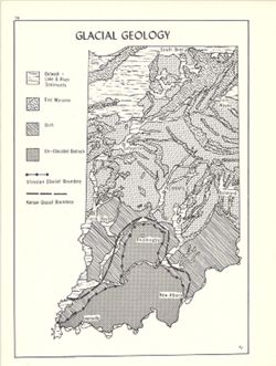
- Shows outwash (lake and river sediments), end moraines, drift and un-glaciated bedrock. Also shows Illinoian glacial boundary and Kansas glacial boundary. ...
- Call Number:
- G4091.C5 1970 .K56
- Caption:
- Imprint: Bloomington, Indiana : Department of Geography, Indiana University, [1970]
- Physical Description:
- Scale: Approximately 1:2,000,000 and Dimensions: 26 x 18 cm, on sheet 28 x 21 cm
- Alternate Identifier:
- Alternate ID: 317383IP and Title Control Number: a15939117
- Persistent URL:
- https://purl.dlib.indiana.edu/iudl/images/VAC3073/VAC3073-M-00201
- Provenance:
- An atlas of Indiana / by Robert C. Kingsbury [1970].
-
- Subject:
- Topical Subject: Labor supply, Topical Subject: Manufacturing industries--Employees, and Geographic Subject: Indiana
- Creator:
- Kingsbury, Robert C. and Hollingsworth, John M.
- Publisher:
- Indiana University. Department of Geography
- Date Created:
- 1970
- Identifier:
- VAC3073-M-00186
- Genre:
- Thematic maps
- Geographic Location:
- Coordinates: W0880700 W0844500 N0414500 N0374600
- Related URL:
- Catalog URL: https://iucat.iu.edu/catalog/15950528
- Abstract:
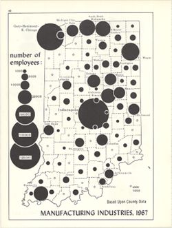
- Graduated symbol map showing number of employees by county. Detached from: An atlas of Indiana / by Robert C. Kingsbury , with contributions from John M. ...
- Call Number:
- G4091.G8 1967 .K58
- Caption:
- Imprint: Bloomington, Indiana : Department of Geography, Indiana University, [1970]
- Physical Description:
- Scale: Approximately 1:1,950,000 and Dimensions: 26 x 18 cm
- Alternate Identifier:
- Alternate ID: 317383IP and Title Control Number: a15950528
- Persistent URL:
- https://purl.dlib.indiana.edu/iudl/images/VAC3073/VAC3073-M-00186
- Provenance:
- An atlas of Indiana / by Robert C. Kingsbury [1970].
-
- Subject:
- Topical Subject: Retail trade--Employees, Geographic Subject: Indiana, and Topical Subject: Labor supply
- Creator:
- Hollingsworth, John M. and Kingsbury, Robert C.
- Publisher:
- Indiana University. Department of Geography
- Date Created:
- 1970
- Identifier:
- VAC3073-M-00179
- Genre:
- Thematic maps
- Geographic Location:
- Coordinates: W0880700 W0844500 N0414500 N0374600
- Related URL:
- Catalog URL: https://iucat.iu.edu/catalog/15987122
- Abstract:
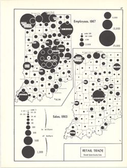
- 2 maps on 1 sheet, Retail trade employees, 1967, and Retail trade sales, 1963. Graduated symbol map. Detached from: An atlas of Indiana / by Robert C. Kin...
- Call Number:
- G4091.G8 1963 .K57
- Caption:
- Imprint: Bloomington, Indiana : Department of Geography, Indiana University, [1970]
- Physical Description:
- Dimensions: on sheet 28 x 21 cm and Scale: Approximately 1:2,700,000
- Alternate Identifier:
- Alternate ID: 317383IP and Title Control Number: a15987122
- Persistent URL:
- https://purl.dlib.indiana.edu/iudl/images/VAC3073/VAC3073-M-00179
- Provenance:
- An atlas of Indiana / by Robert C. Kingsbury [1970].
-
- Subject:
- Geographic Subject: Indiana, Topical Subject: Furniture industry and trade, Topical Subject: Labor supply, Topical Subject: Forest products industry, and Top...
- Creator:
- Kingsbury, Robert C. and Hollingsworth, John M.
- Publisher:
- Indiana University, Bloomington. Department of Geography
- Date Created:
- 1970
- Identifier:
- VAC3073-M-00174
- Genre:
- Thematic maps and Statistical maps
- Geographic Location:
- Coordinates: W0880700 W0844500 N0414500 N0374600
- Related URL:
- Catalog URL: https://iucat.iu.edu/catalog/18452119
- Abstract:
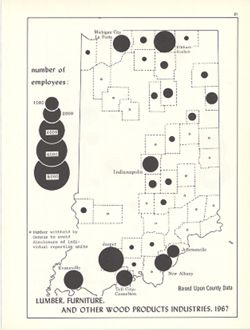
- Choropleth map with graduated circles showing the number of employees in each county employed by wood product industries in 1967. "Based upon county dat...
- Call Number:
- G4091.G8 1967 .K55
- Caption:
- Imprint: [Bloomington, Indiana] : [Department of Geography, Indiana University], [1970]
- Physical Description:
- Scale: Scale not given. and Dimensions: 26 x 18 cm
- Alternate Identifier:
- Alternate ID: 317383IP and Title Control Number: a18452119
- Persistent URL:
- https://purl.dlib.indiana.edu/iudl/images/VAC3073/VAC3073-M-00174
- Provenance:
- An atlas of Indiana / by Robert C. Kingsbury [1970].
-
- Subject:
- Topical Subject: Farm tractors, Topical Subject: SYMAP (Computer program language), Geographic Subject: Indiana, and Topical Subject: Pastures
- Creator:
- Indiana University. Research Computing Center and Kingsbury, Robert C.
- Publisher:
- Indiana University. Department of Geography
- Date Created:
- 1970
- Identifier:
- VAC3073-M-00148
- Genre:
- Thematic maps
- Geographic Location:
- Coordinates: W0880700 W0844500 N0414500 N0374600
- Related URL:
- Catalog URL: https://iucat.iu.edu/catalog/15995411
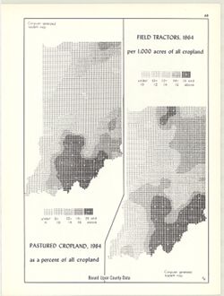
- Abstract:
- 2 maps on 1 sheet, Pastured cropland, 1964, as a percent of all cropland and Field tractors, 1964, per 1,000 acres of all cropland. Computer generated isople...
- Call Number:
- G4091.J5 1964 .K55
- Caption:
- Imprint: Bloomington, Indiana : Department of Geography, Indiana University, [1970]
- Physical Description:
- Scale: Approximately 1:3,000,000 and Dimensions: each 26 x 10 cm, on sheet 28 x 21 cm
- Alternate Identifier:
- Title Control Number: a15995411 and Alternate ID: 317383IP
- Persistent URL:
- https://purl.dlib.indiana.edu/iudl/images/VAC3073/VAC3073-M-00148
- Provenance:
- An atlas of Indiana / by Robert C. Kingsbury [1970].
-
- Subject:
- Topical Subject: Rain and rainfall, Topical Subject: SYMAP (Computer program language), and Geographic Subject: Indiana
- Creator:
- Kingsbury, Robert C. and Indiana University. Research Computing Center
- Publisher:
- Indiana University. Department of Geography
- Date Created:
- 1970
- Identifier:
- VAC3073-M-00141
- Genre:
- Thematic maps
- Geographic Location:
- Coordinates: W0880700 W0844500 N0414500 N0374600
- Related URL:
- Catalog URL: https://iucat.iu.edu/catalog/15995731
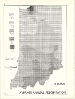
- Abstract:
- Computer generated isometric map obtained through use of the facilities of Indiana University's Research Computer Center. ASCII-art map created using SYM...
- Call Number:
- G4091.C883 1970 .K56
- Caption:
- Imprint: Bloomington, Indiana : Department of Geography, Indiana University, [1970]
- Physical Description:
- Dimensions: 26 x 18 cm and Scale: Approximately 1:1,950,000
- Alternate Identifier:
- Title Control Number: a15995731 and Alternate ID: 317383IP
- Persistent URL:
- https://purl.dlib.indiana.edu/iudl/images/VAC3073/VAC3073-M-00141
- Provenance:
- An atlas of Indiana / by Robert C. Kingsbury [1970].
-
- Subject:
- Geographic Subject: Indiana and Topical Subject: Soils
- Creator:
- Kingsbury, Robert C. and Hollingsworth, John M.
- Publisher:
- Indiana University. Department of Geography
- Date Created:
- 1970
- Identifier:
- VAC3073-M-00134
- Genre:
- Thematic maps
- Geographic Location:
- Coordinates: W0880700 W0844500 N0414500 N0374600
- Related URL:
- Catalog URL: https://iucat.iu.edu/catalog/15939800
- Abstract:
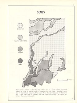
- Detached from: An atlas of Indiana / by Robert C. Kingsbury , with contributions from John M. Hollingsworth and others. Bloomington, Indiana : Department of ...
- Call Number:
- G4091.J3 1970 .K56
- Caption:
- Imprint: Bloomington, Indiana : Department of Geography, Indiana University, [1970]
- Physical Description:
- Dimensions: 26 x 18 cm, on sheet 28 x 21 cm and Scale: Approximately 1:2,300,000
- Alternate Identifier:
- Alternate ID: 317383IP and Title Control Number: a15939800
- Persistent URL:
- https://purl.dlib.indiana.edu/iudl/images/VAC3073/VAC3073-M-00134
- Provenance:
- An atlas of Indiana / by Robert C. Kingsbury [1970].
-
- Subject:
- Geographic Subject: Indiana, Topical Subject: Soybean--Geographical distribution, and Topical Subject: SYMAP (Computer program language)
- Creator:
- Kingsbury, Robert C. and Hollingsworth, John M.
- Publisher:
- Indiana University. Department of Geography
- Date Created:
- 1970
- Identifier:
- VAC3073-M-00086
- Genre:
- Thematic maps
- Geographic Location:
- Coordinates: W0880700 W0844500 N0414500 N0374600
- Related URL:
- Catalog URL: https://iucat.iu.edu/catalog/15984680
- Abstract:
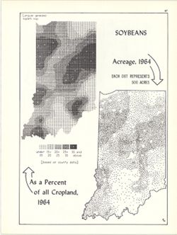
- Dot distribution map. Includes ancillary computer generated isopleth map Soybeans as a percent of all cropland, 1964. ASCII-art map created using SYMAP or si...
- Call Number:
- G4091.J67 1964 .K56
- Caption:
- Imprint: Bloomington, Indiana : Department of Geography, Indiana University, [1970]
- Physical Description:
- Scale: Approximately 1:2,534,400 and Dimensions: 26 x 18 cm, on sheet 28 x 21 cm
- Alternate Identifier:
- Alternate ID: 317383IP and Title Control Number: a15984680
- Persistent URL:
- https://purl.dlib.indiana.edu/iudl/images/VAC3073/VAC3073-M-00086
- Provenance:
- An atlas of Indiana / by Robert C. Kingsbury [1970].
-
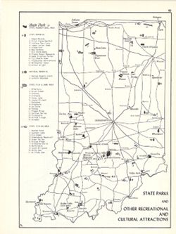
- Subject:
- Topical Subject: Parks, Topical Subject: Memorials, Geographic Subject: Indiana, Topical Subject: Wildlife management areas, and Topical Subject: Outdoor rec...
- Creator:
- Kingsbury, Robert C. and Hollingsworth, John M.
- Publisher:
- Indiana University. Department of Geography
- Date Created:
- 1970
- Identifier:
- VAC3073-M-00073
- Genre:
- Tourist maps and Thematic maps
- Geographic Location:
- Coordinates: W0880700 W0844500 N0414500 N0374600
- Related URL:
- Catalog URL: https://iucat.iu.edu/catalog/15938145
- Abstract:
- Shows state parks and state recreational areas, national and state memorials, state fish & game areas, and state fishing areas. Includes index. Detach...
- Call Number:
- G4091.G52 1969 .K56
- Caption:
- Imprint: Bloomington, Indiana : Department of Geography, Indiana University, [1970]
- Physical Description:
- Dimensions: 26 x 18 cm, on sheet 28 x 21 cm and Scale: Approximately 1:1,850,000
- Alternate Identifier:
- Alternate ID: 317383IP and Title Control Number: a15938145
- Persistent URL:
- https://purl.dlib.indiana.edu/iudl/images/VAC3073/VAC3073-M-00073
- Provenance:
- An atlas of Indiana / by Robert C. Kingsbury [1970].
-
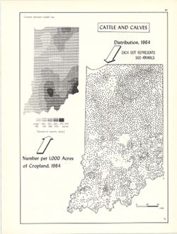
- Subject:
- Topical Subject: SYMAP (Computer program language), Geographic Subject: Indiana, and Topical Subject: Cattle--Geographical distribution
- Creator:
- Hollingsworth, John M., Indiana University. Research Computing Center, and Kingsbury, Robert C.
- Publisher:
- Indiana University. Department of Geography
- Date Created:
- 1970
- Identifier:
- VAC3073-M-00066
- Genre:
- Thematic maps
- Geographic Location:
- Coordinates: W0880700 W0844500 N0414500 N0374600
- Related URL:
- Catalog URL: https://iucat.iu.edu/catalog/15736851
- Abstract:
- Dot distribution map. Includes ancillary computer generated isopleth map Cattle and calves: number per 1,000 acres of cropland, 1964. ASCII-art map created u...
- Call Number:
- G4091.J5 1964 .K56
- Caption:
- Imprint: Bloomington, Indiana : Department of Geography, Indiana University, [1970]
- Physical Description:
- Scale: 1:2,534,400 and Dimensions: 26 x 18 cm
- Alternate Identifier:
- Alternate ID: 317383IP and Title Control Number: a15736851
- Persistent URL:
- https://purl.dlib.indiana.edu/iudl/images/VAC3073/VAC3073-M-00066
- Provenance:
- An atlas of Indiana / by Robert C. Kingsbury [1970].
