
Search Constraints
You searched for:
Collections
Indiana Historic Maps
Remove constraint Collections: Indiana Historic Maps
Subject
Geographic Subject: Indianapolis (Ind.)
Remove constraint Subject: Geographic Subject: Indianapolis (Ind.)
« Previous |
1 - 10 of 39
|
Next »
Search Results
-
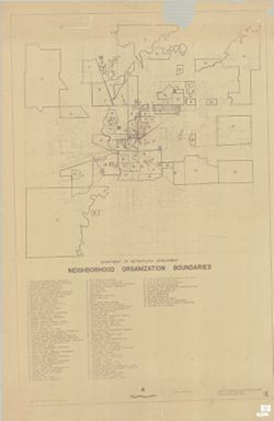
- Subject:
- Topical Subject: Boundaries, Topical Subject: Neighborhoods, Topical Subject: Community organization, Geographic Subject: Indianapolis (Ind.), and Geographic...
- Creator:
- Indianapolis (Ind.). Division of Planning & Zoning
- Publisher:
- [Dept. of Metropolitan Development, Division of Planning and Zoning?]
- Date Created:
- 1972
- Identifier:
- VAC3073-M-00889
- Genre:
- Thematic maps
- Geographic Location:
- Coordinates: W0861941 W0855614 N0395538 N0393755
- Related URL:
- Catalog URL: https://iucat.iu.edu/catalog/6289116
- Abstract:
- Blueline. Includes indexed list of neighborhood organizations.
- Call Number:
- G4093.M3 E6 1972 .I5
- Caption:
- Imprint: [Indianapolis?]: [Dept. of Metropolitan Development, Division of Planning and Zoning?], [1972?]
- Physical Description:
- Dimensions: 151 x 101 cm and Scale: 1:36,000
- Alternate Identifier:
- Title Control Number: a6289116
- Persistent URL:
- https://purl.dlib.indiana.edu/iudl/images/VAC3073/VAC3073-M-00889
-
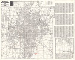
- Subject:
- Geographic Subject: Indianapolis Metropolitan Area (Ind.) and Geographic Subject: Indianapolis (Ind.)
- Creator:
- Metro Graphic Arts
- Publisher:
- [publisher not identified]
- Date Created:
- 1975
- Identifier:
- VAC3073-M-00864
- Genre:
- Maps
- Geographic Location:
- Coordinates: W0861941 W0855614 N0395538 N0393755
- Related URL:
- Catalog URL: https://iucat.iu.edu/catalog/5322622
- Abstract:
- Plastic index device in pocket. Includes indexes, A-C of street index on attached sheet and "Inset map of adjacent areas in Johnson County."
- Call Number:
- G4094 .I4 1975 .M4
- Caption:
- Imprint: Grand Rapids, Mich. : [publisher not identified], 1975.
- Physical Description:
- Dimensions: 128 x 119 cm and Scale: 1:29,000
- Alternate Identifier:
- Title Control Number: a5322622
- Persistent URL:
- https://purl.dlib.indiana.edu/iudl/images/VAC3073/VAC3073-M-00864
-
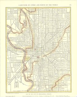
- Subject:
- Geographic Subject: Indianapolis (Ind.)
- Publisher:
- [New York] : P. F. Collier & Son, 1911.
- Identifier:
- VAC3073-M-01582
- Genre:
- Maps
- Geographic Location:
- Coordinates: W0861142 W0860735 N0394758 N0394409
- Related URL:
- Catalog URL: https://iucat.iu.edu/catalog/15471922
- Abstract:
- Shows states and principal cities indexed in margin. Inset maps show Hamburg and Berlin. Shows cities, towns, and railroads. "Copyright, 1911, by P....
- Call Number:
- G4094.I4 1911.C65
- Physical Description:
- Dimensions: 30 x 23 cm
- Persistent URL:
- https://purl.dlib.indiana.edu/iudl/images/VAC3073/VAC3073-M-01582
-
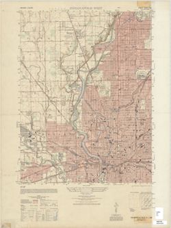
- Subject:
- Geographic Subject: Indianapolis (Ind.) and Geographic Subject: Marion County (Ind.)
- Publisher:
- United States. Army Map Service
- Date Created:
- 1948
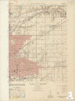
- Identifier:
- VAC3073-M-01431
- Genre:
- Topographic maps, Quadrangle maps, and 7.5 minute topographic maps
- Geographic Location:
- Coordinates: W0861500 W0860730 N0395230 N0394500
- Related URL:
- Catalog URL: https://iucat.iu.edu/catalog/18376531
- Abstract:
- Printed with vegetation. Prepared under the direction of the Chief of Engineers by the Army Map Service (AM), Corps of Engineers, Department of the Army , ...
- Call Number:
- G4090 s25 .U5 Indianapolis West 1948 V
- Caption:
- Imprint: Washington, D.C. : Army Map Service, 1948.
- Physical Description:
- Scale: 1:25,000 and Dimensions: 56 x 45 cm or smaller
- Alternate Identifier:
- Title Control Number: a18376531
- Persistent URL:
- https://purl.dlib.indiana.edu/iudl/images/VAC3073/VAC3073-M-01431
- Provenance:
- Part of United States. Army Map Service, Indiana 1:25,000.
-
- Subject:
- Geographic Subject: Indianapolis (Ind.) and Geographic Subject: Marion County (Ind.)
- Creator:
- United States. Army Map Service and Geological Survey (U.S.)
- Publisher:
- United States. Army Map Service
- Date Created:
- 1949
- Identifier:
- VAC3073-M-01430
- Genre:
- Topographic maps, 7.5 minute topographic maps, and Quadrangle maps
- Geographic Location:
- Coordinates: W0860730 W0860000 N0395230 N0394500
- Related URL:
- Catalog URL: https://iucat.iu.edu/catalog/15733273
- Abstract:
- Prepared under the direction of the Chief of Engineers by the Army Map Service (AM), Corps of Engineers, Department of the Army. Relief shown by contours and...
- Call Number:
- G4090 s25 .U5 Indianapolis East 1948
- Caption:
- Imprint: Washington, D.C. : Army Map Service, Corps of Engineers, Department of the Army, 1949.
- Physical Description:
- Dimensions: 56 x 43 cm, on sheet 74 x 56 cm and Scale: 1:25,000
- Alternate Identifier:
- Title Control Number: a15733273
- Persistent URL:
- https://purl.dlib.indiana.edu/iudl/images/VAC3073/VAC3073-M-01430
- Provenance:
- Part of United States. Army Map Service, Indiana 1:25,000.
-
![Map of the City of Indianapolis and its suburbs [map]](https://iiif.uits.iu.edu/iiif/2/v692v943f%2Ffiles%2Fcb6898c0-54f1-4245-b5e2-96cd8bf1b867/full/250,/0/default.jpg)
- Subject:
- Geographic Subject: Indianapolis Metropolitan Area (Ind.), Topical Subject: Schools, Topical Subject: Administrative and political divisions, Geographic Subj...
- Creator:
- Palmer, Thos. W. (Thomas W.) and Carpenter, H. C.
- Publisher:
- Baker & Randolph
- Date Created:
- 1889
- Identifier:
- VAC3073-M-01274
- Genre:
- Maps and Cadastral maps
- Geographic Location:
- Coordinates: W0860929 W0860929 N0394606 N0394606
- Related URL:
- Catalog URL: new.iucat.iu.edu/catalog/4665173
- Abstract:
- Surveyed and compiled from official records by H.C Carpenter , Thos. W. Palmer, draughtsman. Cadastral map showing landowners. Shows ward and school district...
- Call Number:
- G4094.I4G46 1889 .C37
- Caption:
- Imprint: Indianapolis : Baker & Randolph, [c1889]
- Physical Description:
- Scale: Approximately 1:7,150 and Dimensions: 159 x 206 cm, on sheets 89 x 57 cm or smaller
- Persistent URL:
- https://purl.dlib.indiana.edu/iudl/images/VAC3073/VAC3073-M-01274
- Provenance:
- H.C Carpenter
-
- Subject:
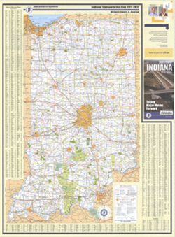
- Geographic Subject: Indianapolis (Ind.), Topical Subject: Roads, Topical Subject: Central business districts, and Geographic Subject: Indiana
- Creator:
- Indiana. Department of Transportation
- Publisher:
- Indiana. Department of Transportation
- Date Created:
- 2011
- Identifier:
- VAC3073-M-01235
- Genre:
- Road maps
- Geographic Location:
- Coordinates: W0880500 W0844700 N0414500 N0374600
- Related URL:
- Catalog URL: https://iucat.iu.edu/catalog/a18406192
- Abstract:
- Panel title: Indiana, 2011/2012, taking major moves forward. Includes indexes, note, and color illustrations. Text, indexed map of "Downtown Indianapoli...
- Call Number:
- G1403 .S7 2011-2012
- Caption:
- Imprint: [Indianapolis] : Indiana Department of Transportation, [2011]
- Physical Description:
- Dimensions: 94 x 59 cm and Scale: Approximately 1:550,000
- Alternate Identifier:
- Title Control Number: a18406192
- Persistent URL:
- https://purl.dlib.indiana.edu/iudl/images/VAC3073/VAC3073-M-01235
- Provenance:
- Indiana state highway system
-
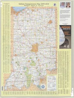
- Subject:
- Topical Subject: Roads, Geographic Subject: Indianapolis (Ind.), Topical Subject: Central business districts, and Geographic Subject: Indiana
- Creator:
- Indiana. Department of Transportation. Graphic Engineering Division
- Publisher:
- Indiana. Department of Transportation
- Date Created:
- 2009
- Identifier:
- VAC3073-M-01234
- Genre:
- Road maps
- Geographic Location:
- Coordinates: W0880500 W0844700 N0414500 N0374600
- Related URL:
- Catalog URL: https://iucat.iu.edu/catalog/18406189
- Abstract:
- Panel title: Indiana, 2009/2010, accelerating Indiana's economic development. Includes indexes, note, and color illustrations. Text, indexed map of "...
- Call Number:
- G1403 .S7 2009-2010
- Caption:
- Imprint: Indianapolis, Ind. : Indiana Department of Transportation, [2009]
- Physical Description:
- Scale: Approximately 1:560,000 and Dimensions: 94 x 59 cm
- Alternate Identifier:
- Title Control Number: a18406189
- Persistent URL:
- https://purl.dlib.indiana.edu/iudl/images/VAC3073/VAC3073-M-01234
- Provenance:
- Indiana state highway system
-
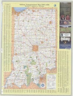
- Subject:
- Topical Subject: Roads, Topical Subject: Central business districts, Geographic Subject: Indianapolis (Ind.), and Geographic Subject: Indiana
- Creator:
- Indiana. Department of Transportation. Graphic Engineering Division
- Publisher:
- Indiana. Department of Transportation
- Date Created:
- 2005
- Identifier:
- VAC3073-M-01233
- Genre:
- Road maps
- Geographic Location:
- Coordinates: W0880500 W0844700 N0414500 N0374600
- Related URL:
- Catalog URL: https://iucat.iu.edu/catalog/18406187
- Abstract:
- Panel title: Indiana 2005-2006. Includes indexes, note, and color illustrations. Text, indexed map of "Downtown Indianapolis," 16 local route maps,...
- Call Number:
- G1403 .S7 2005-2006
- Caption:
- Imprint: [Indianapolis, Ind.] : distributed by State Representative Peggy Welch, District 60, [2005] and Imprint: Indianapolis, Ind. : Indiana Department of ...
- Physical Description:
- Scale: Approximately 1:560,000 and Dimensions: 94 x 59 cm
- Alternate Identifier:
- Title Control Number: a18406187
- Persistent URL:
- https://purl.dlib.indiana.edu/iudl/images/VAC3073/VAC3073-M-01233
- Provenance:
- Indiana state highway system
-
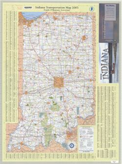
- Subject:
- Topical Subject: Roads, Geographic Subject: Indiana, Geographic Subject: Indianapolis (Ind.), and Topical Subject: Central business districts
- Creator:
- Indiana. Department of Transportation. Graphic Engineering Division
- Publisher:
- Indiana. Department of Transportation
- Date Created:
- 2003
- Identifier:
- VAC3073-M-01230
- Genre:
- Road maps
- Geographic Location:
- Coordinates: W0880500 W0844700 N0414500 N0374600
- Related URL:
- Catalog URL: https://iucat.iu.edu/catalog/18406179
- Abstract:
- Panel title: 2003 Indiana : Lewis & Clark ... a bicentennial celebration 1803-2003. Includes indexes, note, and color illustrations. Text, indexed map of...
- Call Number:
- G1403 .S7 2003
- Caption:
- Imprint: Indianapolis, Ind. : Indiana Department of Transportation, [2003]
- Physical Description:
- Scale: Approximately 1:560,000 and Dimensions: 94 x 59 cm
- Alternate Identifier:
- Title Control Number: a18406179
- Persistent URL:
- https://purl.dlib.indiana.edu/iudl/images/VAC3073/VAC3073-M-01230
- Provenance:
- Indiana state highway system

- « Previous
- Next »
- 1
- 2
- 3
- 4