
Search Constraints
You searched for:
Publisher
Indiana. Department of Geology and Natural Resources
Remove constraint Publisher: Indiana. Department of Geology and Natural Resources
Search Results
-
- Subject:
- Geographic Subject: Franklin County (Ind.), Topical Subject: Geology, Topical Subject: IGS Annual Reports, and Geographic Subject: Decatur County (Ind.)
- Creator:
- Foerste, Aug. F. (Aug. Frederic), 1862-1936
- Publisher:
- Indiana. Department of Geology and Natural Resources
- Date Created:
- 1898
- Identifier:
- VAC3073-M-00631
- Genre:
- Geological maps
- Geographic Location:
- Coordinates: W0852152 W0850747 N0393129 N0391606
- Related URL:
- Catalog URL: https://iucat.iu.edu/catalog/17227850
- Abstract:
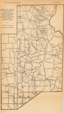
- Plate XVII. "Report of State Geologist, 1897, plate xvii." Detached from: A report on the Niagara limestone quarries of Decatur, Franklin and...
- Call Number:
- G4093.F7C5 1897 .F64
- Caption:
- Imprint: [Indianapolis] : [Wm. B. Burford], [1898] and Imprint: [Indianapolis] : [Indiana Department of Geology and Natural Resources], [1898]
- Physical Description:
- Scale: Approximately 1:126,720. 2 miles = 1 inch and Dimensions: 25 x 15 cm
- Alternate Identifier:
- Title Control Number: a17227850 and Alternate ID: 390726IP
- Persistent URL:
- https://purl.dlib.indiana.edu/iudl/images/VAC3073/VAC3073-M-00631
- Provenance:
- 22nd Annual Report (1897) / Indiana. Department of Geology and Natural Resources.
-
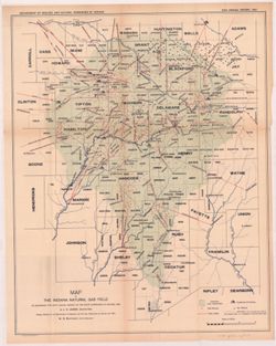
- Subject:
- Geographic Subject: Indiana, Topical Subject: Gas wells, Topical Subject: Gas fields, Topical Subject: Gas pipelines, Topical Subject: Oil wells, and Topical...
- Creator:
- Leach, J. C.
- Publisher:
- Indiana. Department of Geology and Natural Resources
- Date Created:
- 1898
- Identifier:
- VAC3073-M-00627
- Genre:
- Geological maps
- Geographic Location:
- Coordinates: W0863600 W0844800 N0404900 N0390900
- Related URL:
- Catalog URL: https://iucat.iu.edu/catalog/18225077
- Abstract:
- Shows original gas territory, gas wells, pipe lines, pumping stations, oil wells, and limits of territory at present producing gas in east-central Indiana. ...
- Call Number:
- G4091.H8 1897 .L4
- Caption:
- Imprint: Indianapolis, Ind. : Wm. B. Burford, lith., [1898] and Imprint: [Indianapolis?] : Dept. of Geology and Natural Resources of Indiana, [1897]
- Physical Description:
- Scale: Approximately 1:576,000 and Dimensions: 53 x 42 cm
- Alternate Identifier:
- Alternate ID: 390726IP and Title Control Number: a18225077
- Persistent URL:
- https://purl.dlib.indiana.edu/iudl/images/VAC3073/VAC3073-M-00627
- Provenance:
- 22nd Annual Report (1897) / Indiana. Department of Geology and Natural Resources.
-
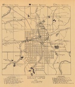
- Subject:
- Geographic Subject: Lawrence County (Ind.), Topical Subject: Stone-cutting, Topical Subject: Limestone industry, Geographic Subject: Bedford (Ind.), and Topi...
- Creator:
- Blatchley, Raymond S. (Raymond Sillliman)
- Publisher:
- Indiana. Department of Geology and Natural Resources
- Date Created:
- 1908
- Identifier:
- VAC3073-M-00628
- Genre:
- Road maps and Thematic maps
- Geographic Location:
- Coordinates: W0863134 W0862736 N0385324 N0385042
- Related URL:
- Catalog URL: https://iucat.iu.edu/catalog/18299189
- Abstract:
- "The 15 etching maps of the individual quarries or quarry districts, have been written and prepared by Raymond S. Blatchley from data gathered by him pe...
- Call Number:
- G4094.B3M2 1907 .B53
- Caption:
- Imprint: [Indianapolis] : [Indiana Department of Geology and Natural Resources], [1908]
- Physical Description:
- Dimensions: 23 x 20 cm and Scale: Scale not given.
- Alternate Identifier:
- Alternate ID: 390726IP and Title Control Number: a18299189
- Persistent URL:
- https://purl.dlib.indiana.edu/iudl/images/VAC3073/VAC3073-M-00628
- Provenance:
- 32nd Annual Report (1907) / Indiana. Department of Geology and Natural Resources.
-
![Township 2 south, range 7 west [Indiana]](https://iiif.uits.iu.edu/iiif/2/2b88rf889%2Ffiles%2F8503c6af-2a95-4ca4-acde-dcd4736a0d0c/full/250,/0/default.jpg)
- Subject:
- Topical Subject: Coal reserves, Geographic Subject: Pike County (Ind.), Topical Subject: Geology, Stratigraphic, and Topical Subject: IGS Annual Reports
- Publisher:
- Indiana. Department of Geology and Natural Resources
- Date Created:
- 1899
- Identifier:
- VAC3073-M-00614
- Genre:
- Geological cross-sections and Geological maps
- Geographic Location:
- Coordinates: W0871432 W0870735 N0382243 N0381721
- Related URL:
- Catalog URL: http://www.iucat.iu.edu/catalog/18418128
- Abstract:
- Relief shown by profile. Other title from Bureau of Land Management database: IN T2S R7W. 20 columnar sections showing coal measures and location map for unn...
- Call Number:
- G4093.P4H9 1898 .T6
- Caption:
- Imprint: [Indianapolis] : [Wm. B. Burford], [1899] and Imprint: [Indianapolis] : [Indiana, Dept. of Geology and Natural History], [1899]
- Physical Description:
- Dimensions: 23 x 27 cm and Scale: Approximately 1:63,360. Vertical scale not given
- Alternate Identifier:
- Title Control Number: a18418128 and Alternate ID: 390726IP
- Persistent URL:
- https://purl.dlib.indiana.edu/iudl/images/VAC3073/VAC3073-M-00614
- Provenance:
- 23rd Annual Report (1898) / Indiana. Department of Geology and Natural Resources.
-
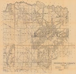
- Subject:
- Geographic Subject: Washington County (Ind.) and Topical Subject: Soils
- Creator:
- Indiana. Department of Geology and Natural Resources
- Publisher:
- Indiana. Department of Geology and Natural Resources
- Date Created:
- 1908
- Identifier:
- VAC3073-M-00603
- Genre:
- Thematic maps
- Geographic Location:
- Coordinates: W0861836 W0855051 N0384700 N0382504
- Related URL:
- Catalog URL: https://iucat.iu.edu/catalog/16096233
- Abstract:
- Shows railroads, dirt roads, improved roads, school houses, and churches. Detached from: Soil survey of Monroe, Brown, Lawrence, Martin, Orange, Washingto...
- Call Number:
- G4093.W5J3 1907 .I53
- Caption:
- Imprint: [Indianapolis] : [Indiana Department of Geology and Natural Resources], [1908]
- Physical Description:
- Scale: Approximately 1:63,360 and Dimensions: 67 x 68 cm
- Alternate Identifier:
- Title Control Number: a16096233 and Alternate ID: 390726IP
- Persistent URL:
- https://purl.dlib.indiana.edu/iudl/images/VAC3073/VAC3073-M-00603
- Provenance:
- 32nd Annual Report (1907) / Indiana. Department of Geology and Natural Resources.
-
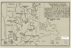
- Subject:
- Topical Subject: Lakes, Geographic Subject: Monroe, Lake (Ind.), and Topical Subject: Reservoirs
- Creator:
- Duthie, Glenn
- Publisher:
- Indiana. Department of Geology and Natural Resources
- Date Created:
- 1981
- Identifier:
- VAC3073-M-00405
- Genre:
- Thematic maps
- Geographic Location:
- Coordinates: W0863112 W0861853 N0390703 N0385942
- Related URL:
- Catalog URL: https://iucat.iu.edu/catalog/5327399
- Abstract:
- "File no. 300-74, 2-23-81." Includes chart showing recreational facilities. Text, illustrations, and location map on verso. "Recreation facili...
- Call Number:
- G4092.M6 1981 .D88
- Caption:
- Imprint: [Indianapolis?] : [Indiana Dept. of Natural Resources?], [1981?]
- Physical Description:
- Dimensions: 26 x 41 cm and Scale: Scale not given.
- Alternate Identifier:
- Title Control Number: a5327399
- Persistent URL:
- https://purl.dlib.indiana.edu/iudl/images/VAC3073/VAC3073-M-00405
-
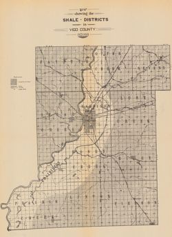
- Subject:
- Topical Subject: Mines and mineral resources, Topical Subject: IGS Annual Reports, Topical Subject: Shale, and Geographic Subject: Vigo County (Ind.)
- Publisher:
- Indiana. Department of Geology and Natural Resources
- Date Created:
- 1905
- Identifier:
- VAC3073-M-00397
- Genre:
- Geological maps
- Geographic Location:
- Coordinates: W0873635 W0871156 N0393634 N0391532
- Related URL:
- Catalog URL: https://iucat.iu.edu/catalog/18282217
- Abstract:
- Shows shale deposits, coal mines, and railroads. Detached from: The clays and clay industries of Indiana / W.S. Blatchley. In Indiana Dept. of Geology and...
- Call Number:
- G4093.V5C5 1904 .M37
- Caption:
- Imprint: [Indianapolis] : [Wm. B. Burford], [1905] and Imprint: [Indianapolis] : [Indiana Department of Geology and Natural Resources], [1905]
- Physical Description:
- Scale: Approximately 1:150,000 and Dimensions: on sheet 36 x 27 cm
- Alternate Identifier:
- Alternate ID: 390726IP and Title Control Number: a18282217
- Persistent URL:
- https://purl.dlib.indiana.edu/iudl/images/VAC3073/VAC3073-M-00397
- Provenance:
- 29th Annual Report (1904) / Indiana. Department of Geology and Natural Resources.
-
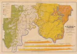
- Subject:
- Topical Subject: Geology, Stratigraphic, Topical Subject: Geology, Geographic Subject: Indiana, Topical Subject: Mines and mineral resources, and Topical Sub...
- Creator:
- Ashley, Geo. H. (George Hall), 1866-1951, Blatchley, W. S. (Willis Stanley), 1859-1940, and Kindle, E. M. (Edward Martin), 1869-1940
- Publisher:
- Indiana. Department of Geology and Natural Resources
- Date Created:
- 1903
- Identifier:
- VAC3073-M-00394
- Genre:
- Geological cross-sections and Geological maps
- Geographic Location:
- Coordinates: W0864835 W0854540 N0382520 N0375015
- Related URL:
- Catalog URL: https://iucat.iu.edu/catalog/16076820
- Abstract:
- From the 27th Annual report of the Department of Geology and Natural Resources of Indiana, 1902. Includes three East-West cross-sections: through New Amsterd...
- Call Number:
- G4091.C5 1902 .A81
- Caption:
- Imprint: [Indianapolis] : [Wm. B. Burford], [1903] and Imprint: [Indianapolis] : [Indiana Department of Geology and Natural Resources], [1902]
- Physical Description:
- Scale: Approximately 1:126,720. 2 miles = 1 in. Vertical scale approximately 1:9,600. 800 feet = 1 in. and Dimensions: 51 x 76 cm, on sheet 56 x 80 cm
- Alternate Identifier:
- Title Control Number: a16076820 and Alternate ID: 390726IP
- Persistent URL:
- https://purl.dlib.indiana.edu/iudl/images/VAC3073/VAC3073-M-00394
- Provenance:
- 27th Annual Report (1902) / Indiana. Department of Geology and Natural Resources.
-
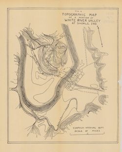
- Subject:
- Topical Subject: IGS Annual Reports, Topical Subject: Rivers, Geographic Subject: White River Valley (Ind.), Geographic Subject: Shoals (Ind.), Topical Subje...
- Publisher:
- Indiana. Department of Geology and Natural Resources
- Date Created:
- 1911
- Identifier:
- VAC3073-M-00393
- Genre:
- Topographic maps
- Geographic Location:
- Coordinates: W0864835 W0864633 N0384050 N0383903
- Related URL:
- Catalog URL: https://iucat.iu.edu/catalog/18418396
- Abstract:
- Relief shown by contours. Contour interval 10 feet. Shows proposed canal routes, proposed dam location, and power house. At head of title: "Fig. 4."...
- Call Number:
- G4093.M5C2 1910 .T6
- Caption:
- Imprint: [Indianapolis] : [Indiana Department of Geology and Natural Resources], [1911] and Imprint: [Indianapolis] : [Wm. B. Burford], [1911]
- Physical Description:
- Scale: Approximately 1:11,750 and Dimensions: 28 x 23 cm
- Alternate Identifier:
- Title Control Number: a18418396 and Alternate ID: 390726IP
- Persistent URL:
- https://purl.dlib.indiana.edu/iudl/images/VAC3073/VAC3073-M-00393
- Provenance:
- 35th Annual Report (1910) / Indiana. Department of Geology and Natural Resources.
-
![Map of the distribution of the Waldron shale in Decatur, Rush, Shelby, and Bartholomew counties, [Indiana]](https://iiif.uits.iu.edu/iiif/2/hh63tz71g%2Ffiles%2F9928330d-568f-4904-a59c-ed2846292533/full/250,/0/default.jpg)
- Subject:
- Geographic Subject: Bartholomew County (Ind.), Geographic Subject: Shelby County (Ind.), Topical Subject: Geology, Stratigraphic--Silurian, Geographic Subjec...
- Creator:
- Price, J. A.
- Publisher:
- Indiana. Department of Geology and Natural Resources
- Date Created:
- 1900
- Identifier:
- VAC3073-M-00392
- Genre:
- Geological maps
- Geographic Location:
- Coordinates: W0854618 W0850902 N0393558 N0390750
- Related URL:
- Catalog URL: https://iucat.iu.edu/catalog/18272889
- Abstract:
- Shows shale locations, quarries, gas wells, schools, churches, and cemeteries. Detached from: A report upon the Waldron shale and its horizon ... / J.A. Pric...
- Call Number:
- G4091.C5 1899 .P7
- Caption:
- Imprint: Indianapolis : Indiana Dept. of Geology and Natural Resources, [1900] and Imprint: Indianapolis, Ind. : Wm. B. Burford, Lith., [1900]
- Physical Description:
- Dimensions: 40 x 33 cm and Scale: Approximately 1:126,720. 2 miles = 1 inch
- Alternate Identifier:
- Alternate ID: 390726IP and Title Control Number: a18272889
- Persistent URL:
- https://purl.dlib.indiana.edu/iudl/images/VAC3073/VAC3073-M-00392
- Provenance:
- 24th Annual Report (1899) / Indiana. Department of Geology and Natural Resources.
