
Search Constraints
You searched for:
Date Created
1958
Remove constraint Date Created: 1958
Collections
Indiana Historic Maps
Remove constraint Collections: Indiana Historic Maps
« Previous |
1 - 10 of 12
|
Next »
Search Results
-
![Brownstown, Ind. [Advance printing]](https://iiif.uits.iu.edu/iiif/2/fq978z86j%2Ffiles%2F6b5e8117-5baf-46e5-8738-ef13b3b78fc6/full/250,/0/default.jpg)
- Subject:
- Geographic Subject: Jackson County (Ind.) and Geographic Subject: Washington County (Ind.)
- Creator:
- EROS Data Center and Mannello, L. R. (Leonard R.)
- Publisher:
- EROS Data Center
- Date Created:
- 1958
- Identifier:
- VAC3073-M-01446
- Genre:
- Topographic maps, 7.5 minute topographic maps, and Quadrangle maps
- Geographic Location:
- Coordinates: W0860730 W0860000 N0385230 N0384500
- Related URL:
- Catalog URL: https://iucat.iu.edu/catalog/18422458
- Abstract:
- EDC , 461 edge worked by L. R. Mannello , 461 [and] 441 edge joined by L. R. Mannello. "EDC, C. Dickey 1958-09-15. ... Scribed by R. Mills." Topogr...
- Call Number:
- G4090 s24 .G4 Indiana 1958 ADV
- Caption:
- Imprint: [Indiana] : EDC, 1958-09-15
- Physical Description:
- Dimensions: on sheet 69 x 56 cm and Scale: 1:24,000
- Alternate Identifier:
- Title Control Number: a18422458
- Persistent URL:
- https://purl.dlib.indiana.edu/iudl/images/VAC3073/VAC3073-M-01446
-
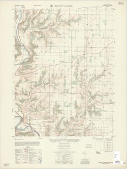
- Subject:
- Geographic Subject: Franklin County (Ind.)
- Creator:
- Geological Survey (U.S.) and United States. Army Map Service
- Publisher:
- United States. Army Map Service
- Date Created:
- 1958
- Identifier:
- VAC3073-M-01438
- Genre:
- Topographic maps, Quadrangle maps, and 7.5 minute topographic maps
- Geographic Location:
- Coordinates: W0850000 W0845230 N0393000 N0392230
- Related URL:
- Catalog URL: https://iucat.iu.edu/catalog/18376544
- Abstract:
- Printed with vegetation. Prepared under the direction of the Chief of Engineers by the Army Map Service (GE), Corps of Engineers, U. S. Army , original map...
- Call Number:
- G4090 s25 .U5 Mount Carmel 1958 V
- Caption:
- Imprint: Washington, D.C. : Army Map Service, Corps of Engineers, [1958].
- Physical Description:
- Scale: 1:25,000 and Dimensions: 56 x 45 cm or smaller
- Alternate Identifier:
- Title Control Number: a18376544
- Persistent URL:
- https://purl.dlib.indiana.edu/iudl/images/VAC3073/VAC3073-M-01438
- Provenance:
- Part of United States. Army Map Service, Indiana 1:25,000.
-
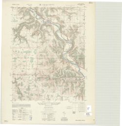
- Subject:
- Geographic Subject: Dearborn County (Ind.) and Geographic Subject: Franklin County (Ind.)
- Creator:
- Geological Survey (U.S.) and United States. Army Map Service
- Publisher:
- United States. Army Map Service
- Date Created:
- 1958
- Identifier:
- VAC3073-M-01423
- Genre:
- 7.5 minute topographic maps, Topographic maps, and Quadrangle maps
- Geographic Location:
- Coordinates: W0850000 W0845230 N0392230 N0391500
- Related URL:
- Catalog URL: https://iucat.iu.edu/catalog/18376105
- Abstract:
- Prepared by the Army Map Service (GE), Corps of Engineers, U. S. Army, Washington D.C. , original map compiled by US Geological Survey. Variant title: India...
- Call Number:
- G4090 s25 .U5 Cedar Grove 1958 V
- Caption:
- Imprint: Washington, D.C. : Army Map Service, Corps of Engineers, 1958.
- Physical Description:
- Scale: 1:25,000 and Dimensions: maps 56 x 45 cm or smaller
- Alternate Identifier:
- Title Control Number: a18376105
- Persistent URL:
- https://purl.dlib.indiana.edu/iudl/images/VAC3073/VAC3073-M-01423
- Provenance:
- Part of United States. Army Map Service, Indiana 1:25,000.
-
![Indiana-Ohio, Winchester Quadrangle [1958 reprint]](https://iiif.uits.iu.edu/iiif/2/6t054k339%2Ffiles%2F32b26c9a-d997-4a33-91af-06b933ded058/full/250,/0/default.jpg)
- Subject:
- Geographic Subject: Darke County (Ohio), Geographic Subject: Wayne County (Ind.), and Geographic Subject: Randolph County (Ind.)
- Creator:
- Smith, Glenn S. (Glenn Shepard), Miller, W. L. (Topographer), Geological Survey (U.S.), Ellis, J. R. (Topographer), Ohio. Division of Geological Survey, Harr...
- Publisher:
- Geological Survey (U.S.)
- Date Created:
- 1958
- Identifier:
- VAC3073-M-01415
- Genre:
- Topographic maps, Quadrangle maps, and 15 minute topographic maps
- Geographic Location:
- Coordinates: W0850000 W0844500 N0401500 N0400000
- Related URL:
- Catalog URL: https://iucat.iu.edu/catalog/18416004
- Abstract:
- W.H. Herron, acting chief geogrpher , Glenn S. Smith, topographic engineer in charge , topography by R.L. Harrison and W.L. Miller , control by J.R. Ellis, J...
- Call Number:
- G4090 s62 .G4 Winchester 1916 rep1958
- Caption:
- Imprint: [Washington, D.C.] : U.S. Geological Survey, 1958
- Physical Description:
- Scale: 1:62,500 and Dimensions: 45 x 42 cm or smaller
- Alternate Identifier:
- Title Control Number: a18416004
- Persistent URL:
- https://purl.dlib.indiana.edu/iudl/images/VAC3073/VAC3073-M-01415
- Provenance:
- Part of Geological Survey (U.S.). Indiana 1:62,500.
-
![Indiana-Illinois, Vincennes quadrangle : topography [1958 reprint with vegetation]](https://iiif.uits.iu.edu/iiif/2/bv73d371v%2Ffiles%2Fd8eeacfe-4380-4ba5-814d-cbf9ec40a053/full/250,/0/default.jpg)
- Subject:
- Geographic Subject: Wabash County (Ill.), Topical Subject: Vegetation mapping, Geographic Subject: Lawrence County (Ill.), Geographic Subject: Gibson County ...
- Creator:
- Geological Survey (U.S.)
- Publisher:
- Geological Survey (U.S.)
- Date Created:
- 1958
- Identifier:
- VAC3073-M-01412
- Genre:
- Quadrangle maps, Topographic maps, and 15 minute topographic maps
- Geographic Location:
- Coordinates: W0874500 W0873000 N0384500 N0383000
- Related URL:
- Catalog URL: https://iucat.iu.edu/catalog/18415517
- Abstract:
- R.B. Marshall, chief geographer , W.H. Herron, geographer in charge , topography by Frank Tweedy, C.L. Sadler, Chas. Hartmann, Jr., L.L. Lee, W.S. Gehres, an...
- Call Number:
- G4090 s62 .G4 Vincennes 1944 rep1958 V
- Caption:
- Imprint: [Washington, D.C.] : U.S. Geological Survey, 1958
- Physical Description:
- Dimensions: 45 x 42 cm or smaller and Scale: 1:62,500
- Alternate Identifier:
- Title Control Number: a18415517
- Persistent URL:
- https://purl.dlib.indiana.edu/iudl/images/VAC3073/VAC3073-M-01412
- Provenance:
- Part of Geological Survey (U.S.). Indiana 1:62,500.
-
![Indiana, 15 minute series (topographic), New Haven quadrangle [1958 printing with vegetation]](https://iiif.uits.iu.edu/iiif/2/2514pp79t%2Ffiles%2F0d5ff364-2218-4a66-8b60-6f38aa96fe7f/full/250,/0/default.jpg)
- Subject:
- Topical Subject: Vegetation mapping, Geographic Subject: Posey County (Ind.), Geographic Subject: Gallatin County (Ill.), Geographic Subject: White County (I...
- Creator:
- Geological Survey (U.S.)
- Publisher:
- Geological Survey (U.S.)
- Date Created:
- 1958
- Identifier:
- VAC3073-M-01360
- Genre:
- Topographic maps, 15 minute topographic maps, and Quadrangle maps
- Geographic Location:
- Coordinates: W0881500 W0880000 N0380000 N0374500
- Related URL:
- Catalog URL: https://iucat.iu.edu/catalog/18413861
- Abstract:
- United States, Department of the Interior, Geological Survey , State of Illinois, Department of Registration and Education, Geological Survey Division , Stat...
- Call Number:
- G4090 s62 .G4 New Haven 1949 rep 1958 V
- Caption:
- Imprint: Washington, D.C. : Interior--Geological Survey, 1958
- Physical Description:
- Scale: 1:62,500 and Dimensions: 45 x 42 cm or smaller
- Alternate Identifier:
- Title Control Number: a18413861
- Persistent URL:
- https://purl.dlib.indiana.edu/iudl/images/VAC3073/VAC3073-M-01360
- Provenance:
- Part of Geological Survey (U.S.). Indiana 1:62,500.
-
![Illinois-Indiana Birds quadrangle : topography [1958 reprint]](https://iiif.uits.iu.edu/iiif/2/vt151n461%2Ffiles%2F8d479352-343d-4029-a644-fe61b614fa55/full/250,/0/default.jpg)
- Subject:
- Geographic Subject: Sullivan County (Ind.), Geographic Subject: Crawford County (Ill.), and Geographic Subject: Knox County (Ind.)
- Creator:
- U.S. Coast and Geodetic Survey, Herron, W. H. (William Harrison), 1865-, Marshall, R. B. (Robert Bradford), 1867-1949, Graff, Fred, Jr., United States. Army,...
- Publisher:
- Geological Survey (U.S.)
- Date Created:
- 1958
- Identifier:
- VAC3073-M-01317
- Genre:
- Quadrangle maps, Topographic maps, and 15 minute topographic maps
- Geographic Location:
- Coordinates: W0874500 W0873000 N0390000 N0384500
- Related URL:
- Catalog URL: https://iucat.iu.edu/catalog/18408528
- Abstract:
- R.B. Marshall, Chief Geographer , W.H. Herron, Geographer in charge , topography by F. Graff, Jr. , control by Corps of Engineers U.S. Army, U.S. Coast and G...
- Call Number:
- G4090 s62 .G4 Birds 1942 rep1958
- Caption:
- Imprint: Washington, D.C. : Interior--Geological Survey, 1958. Washington, D.C. : for sale by U.S. Geological Survey and Imprint: Urbana, Illinois : State Ge...
- Physical Description:
- Scale: 1:62,500 and Dimensions: 45 x 42 cm or smaller
- Alternate Identifier:
- Title Control Number: a18408528
- Persistent URL:
- https://purl.dlib.indiana.edu/iudl/images/VAC3073/VAC3073-M-01317
- Provenance:
- Part of Geological Survey (U.S.). Indiana 1:62,500.
-
![Indiana Bedford quadrangle [1958 reprint with vegetation]](https://iiif.uits.iu.edu/iiif/2/d791tm28h%2Ffiles%2Fef8d95fb-aef9-4832-a975-c3812df114b6/full/250,/0/default.jpg)
- Subject:
- Topical Subject: Vegetation mapping, Geographic Subject: Jackson County (Ind.), Geographic Subject: Lawrence County (Ind.), Geographic Subject: Washington Co...
- Creator:
- Kilmartin, J. O. (Jerome O'Farrell), 1900-1979
- Publisher:
- Geological Survey (U.S.)
- Date Created:
- 1958
- Identifier:
- VAC3073-M-01315
- Genre:
- Quadrangle maps, Topographic maps, and 15 minute topographic maps
- Geographic Location:
- Coordinates: W0863000 W0861500 N0390000 N0384500
- Related URL:
- Catalog URL: https://iucat.iu.edu/catalog/18408529
- Abstract:
- Topography by J. O. Kilmartin, Shirley Waggener, W. H. Austin, G. G. Martin, and C. W. Birdseye. Polyconic projection. Relief shown by contours and spot heig...
- Call Number:
- G4090 s62 .G4 Bedford 1934 rep1958 V.
- Caption:
- Imprint: Washington, D.C. : U.S. Dept. of the Interior, Geological Survey, 1958
- Physical Description:
- Dimensions: 45 x 42 cm or smaller and Scale: 1:62,500
- Alternate Identifier:
- Title Control Number: a18408529
- Persistent URL:
- https://purl.dlib.indiana.edu/iudl/images/VAC3073/VAC3073-M-01315
- Provenance:
- Part of Geological Survey (U.S.). Indiana 1:62,500.
-
- Subject:
- Geographic Subject: Bloomington (Ind.), Geographic Subject: Indiana University, Bloomington, and Topical Subject: Indiana University, Bloomington
- Publisher:
- [Indiana University?]
- Date Created:
- 1958
- Identifier:
- VAC3073-M-00798
- Genre:
- Maps
- Geographic Location:
- Coordinates: W0863138 W0863031 N0391111 N0390950
- Related URL:
- Catalog URL: https://iucat.iu.edu/catalog/5289435
- Abstract:
- Perspective map.
- Call Number:
- G4094.B5:2I6 1958 .I6
- Caption:
- Imprint: [Bloomington?] : [Indiana University?, [1958?]
- Physical Description:
- Scale: Scale not given. and Dimensions: 36 x 25 cm
- Alternate Identifier:
- Title Control Number: a5289435
- Persistent URL:
- https://purl.dlib.indiana.edu/iudl/images/VAC3073/VAC3073-M-00798
-
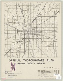
- Subject:
- Geographic Subject: Indianapolis (Ind.), Topical Subject: Highway planning, Topical Subject: Roads, and Geographic Subject: Marion County (Ind.)
- Creator:
- Mahone, Geo. W.
- Publisher:
- Marion County (Ind.). Metropolitan Planning Department
- Date Created:
- 1958
- Identifier:
- VAC3073-M-00724
- Genre:
- Road maps
- Geographic Location:
- Coordinates: W0861941 W0855614 N0395538 N0393755
- Related URL:
- Catalog URL: https://iucat.iu.edu/catalog/6119010
- Abstract:
- "Date of issue: 6-26-58."
- Call Number:
- G4093.M3 P2 1958 .M34
- Caption:
- Imprint: Indianapolis : Metropolitan Planning Department, [1958?]
- Physical Description:
- Dimensions: 41 x 40 cm and Scale: 1:77,000
- Alternate Identifier:
- Title Control Number: a6119010
- Persistent URL:
- https://purl.dlib.indiana.edu/iudl/images/VAC3073/VAC3073-M-00724
