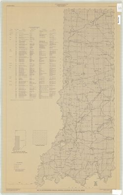
Topical Subject: Coal mines and mining and Geographic Subject: Indiana
Creator:
Hutchison, Harold C. (Harold Christy), 1925-
Publisher:
Indiana. Geological Survey
Date Created:
1970
Identifier:
VAC3073-M-00965
Genre:
Mine maps
Geographic Location:
Coordinates: W0880150 W0862422 N0403746 N0374559
Related URL:
Catalog URL: https://iucat.iu.edu/catalog/5046399
Abstract:
Blue line print. "Base modified from Indiana Department of Conservation, Geological Survey. Base map of portion of western Indiana, 1951." Includ...
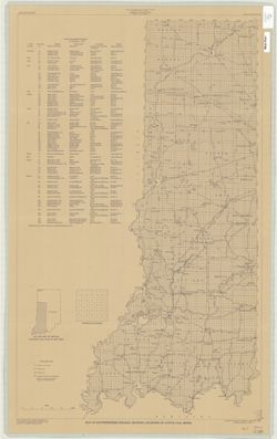
Topical Subject: Coal mines and mining and Geographic Subject: Indiana
Creator:
Hutchison, Harold C. (Harold Christy), 1925-
Publisher:
Indiana. Geological Survey
Date Created:
1974
Identifier:
VAC3073-M-00711
Genre:
Thematic maps and Mine maps
Geographic Location:
Coordinates: W0880100 W0862800 N0403900 N0374500
Related URL:
Catalog URL: https://iucat.iu.edu/catalog/5046466
Abstract:
Blue line print. "Base modified from Indiana Department of Conservation, Geological Survey. Base map of portion of western Indiana, 1951." Includes...
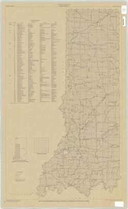
Topical Subject: Coal mines and mining and Geographic Subject: Indiana
Creator:
Hutchison, Harold C. (Harold Christy), 1925-
Publisher:
Indiana. Geological Survey
Date Created:
1975
Identifier:
VAC3073-M-00704
Genre:
Mine maps
Geographic Location:
Coordinates: W0872723 W0862628 N0403749 N0374618
Related URL:
Catalog URL: https://iucat.iu.edu/catalog/5050615
Abstract:
Blue line print. "Base modified from Indiana Department of Conservation, Geological Survey, Base map of portion of western Indiana, 1951." Includes...
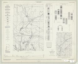
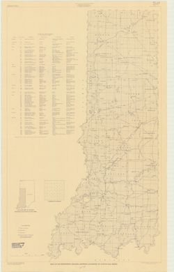
Geographic Subject: Warren County (Ind.), Topical Subject: Coal mines and mining, Geographic Subject: Vermillion County (Ind.), and Geographic Subject: Fount...
Creator:
Hutchison, Harold C. (Harold Christy), 1925-
Publisher:
Indiana. Geological Survey
Date Created:
1961
Identifier:
VAC3073-M-00418
Genre:
Mine maps
Geographic Location:
Coordinates: W0873200 W0870533 N0402800 N0395645
Related URL:
Catalog URL: https://iucat.iu.edu/catalog/4898738
Abstract:
"Preliminary coal map no. 9"--Margin. Includes 1 ancillary map, 1 diagram showing township enumeration, 1 index map, 1 stratigraphic column, and 1 ...
Call Number:
G4093.F6H9 1961 .H88
Caption:
Imprint: Bloomington : Indiana Dept. of Conservation, Geological Survey, 1961.
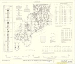
Geographic Subject: Spencer County (Ind.), Topical Subject: Coal mines and mining, and Topical Subject: Coal
Creator:
Hutchison, Harold C. (Harold Christy), 1925-
Publisher:
Indiana. Geological Survey
Date Created:
1959
Identifier:
VAC3073-M-00222
Genre:
Mine maps and Thematic maps
Geographic Location:
Coordinates: W0871600 W0844600 N0381200 N0374700
Related URL:
Catalog URL: https://iucat.iu.edu/catalog/5389271
Abstract:
"Preliminary Coal Map no. 8". Includes 2 geologic cross sections, location map, geologic column, index of mines, tables, and diagram of township se...
Call Number:
G4093.S5H9 1959 .H8
Caption:
Imprint: Bloomington, Ind. : Indiana Department of Conservation, Geological Survey, 1959.