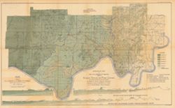
Relief shown by spot heights. Includes map showing coal locations and features, and quarries as well as vertical cross-sections through center of Township 3 ...
Call Number:
G4093.P4H9 1898 .A84
Caption:
Imprint: Indianapolis : Burford, [1899]
Physical Description:
Dimensions: 48 x 78 cm and Scale: Approximately 1:126,720. 1 inch = 2 miles. Vertical scale approximately 1:4,800. 1 inch = 400 feet
Alternate Identifier:
Title Control Number: a18175917 and Alternate ID: 390726IP
Relief shown by profile. Shows two geological cross-sections. "Based upon Congressional land surveys, field work of Ind. Geol. Survey, county atlases.&q...
Call Number:
G4093.W4H9 1898 .A8x
Caption:
Imprint: Indianapolis : Burford, [1899] and Imprint: [Indianapolis, Ind.] : Dept. of Geology and Natural Resources of Indiana, [1899]
Physical Description:
Scale: Approximately 1:126,720. 2 miles = 1 inch. Vertical scale approximately 1:4,800. 400 feet = 1 inch and Dimensions: 49 x 77 cm
Alternate Identifier:
Alternate ID: 390726IP and Title Control Number: a16848969