Geographic Subject: Monroe County (Ind.), Topical Subject: Unincorporated areas, Topical Subject: Land use, Geographic Subject: Smithville (Monroe County, In...
Prepared for the Monroe County Plan Commission by Kenneth L. Schellie & Associates. Shows land use. Includes locator and index maps. 4 maps on 1 sheet: S...
Call Number:
G4093.M7G4 1961 .S34 sheet 14
Caption:
Imprint: [Bloomington, Indiana] : Monroe County Plan Commission, 1961
Physical Description:
Dimensions: 32 x 31 cm or smaller, on sheet 144 x 105 cm and Scale: Approximately 1:6,038
Prepared for the Monroe County Plan Commission by Kenneth L. Schellie & Associates. "Land use survey taken June 1961". Includes locator and ind...
Call Number:
G4093.M7G4 1961 .S34 sheet 13
Caption:
Imprint: [Bloomington, Indiana] : Monroe County Plan Commission, 1961
Physical Description:
Scale: Approximately 1:12,152 and Dimensions: 83 x 81 cm, on sheet 144 x 105 cm
Prepared for the Monroe County Plan Commission by Kenneth L. Schellie & Associates. "Land use survey taken June 1961". Includes locator and ind...
Call Number:
G4093.M7G4 1961 .S34 sheet 6
Caption:
Imprint: [Bloomington, Indiana] : Monroe County Plan Commission, 1961
Physical Description:
Dimensions: 81 x 81 cm, on sheet 144 x 105 cm and Scale: Approximately 1:12,152
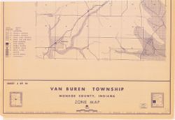
Prepared for the Monroe County Plan Commission by Kenneth L. Schellie & Associates. "Land use survey taken June 1961". Includes locator and ind...
Call Number:
G4093.M7G4 1961 .S34 sheet 10
Caption:
Imprint: [Bloomington, Indiana] : Monroe County Plan Commission, 1961
Physical Description:
Scale: Approximately 1:12,152 and Dimensions: 84 x 71 cm, on sheet 144 x 105 cm
Prepared for the Monroe County Plan Commission by Kenneth L. Schellie & Associates. "Land use survey taken June 1961". Includes locator and ind...
Call Number:
G4093.M7G4 1961 .S34 sheet 5
Caption:
Imprint: [Bloomington, Indiana] : Monroe County Plan Commission, 1961
Physical Description:
Scale: Approximately 1:12,152 and Dimensions: 82 x 81 cm, on sheet 144 x 105 cm
Prepared for the Monroe County Plan Commission by Kenneth L. Schellie & Associates. "Land use survey taken June 1961". Includes locator and ind...
Call Number:
G4093.M7G4 1961 .S34 sheet 9
Caption:
Imprint: [Bloomington, Indiana] : Monroe County Plan Commission, 1961
Physical Description:
Dimensions: 105 x 82 cm, on sheet 144 x 105 cm and Scale: Approximately 1:12,152
Geographic Subject: Perry (Monroe County, Ind. : Township) and Topical Subject: Land use
Creator:
Schellie Associates
Publisher:
Schellie Associates
Date Created:
1961
Identifier:
VAC3073-M-01105
Genre:
Thematic maps
Geographic Location:
Coordinates: W0863423 W0862742 N0390952 N0390442
Related URL:
Catalog URL: https://iucat.iu.edu/catalog/1840934
Abstract:
Prepared for the Monroe County Plan Commission by Kenneth L. Schellie & Associates. "Land use survey taken June 1961". Includes locator and ind...
Call Number:
G4093.M7G4 1961 .S34 sheet 3
Caption:
Imprint: [Bloomington, Indiana] : Monroe County Plan Commission, 1961
Physical Description:
Scale: Approximately 1:12,152 and Dimensions: 82 x 82 cm, on sheet 144 x 105 cm

![[Monroe County, Indiana, existing use of land.] Sheet 14. Unincorporated communities, Monroe County, Indiana, existing use of land](https://iiif.uits.iu.edu/iiif/2/zk51wj270%2Ffiles%2F62b7ef2f-84c1-4e40-a5e2-39ef248cf3ce/full/250,/0/default.jpg)

![[Monroe County, Indiana, existing use of land.] Sheet 13. Washington Township, Monroe County, Indiana, existing use of land](https://iiif.uits.iu.edu/iiif/2/nc581p990%2Ffiles%2F07609495-360c-4713-9c4e-887099eaa1cc/full/250,/0/default.jpg)
![[Monroe County, Indiana, existing use of land.] Sheet 6. Van Buren Township, Monroe County, Indiana, existing use of land](https://iiif.uits.iu.edu/iiif/2/js957j36n%2Ffiles%2Fb7c53c79-855f-4c3c-87bb-abc60884f2ba/full/250,/0/default.jpg)
![[Monroe County, Indiana, existing use of land.] Sheet 10. Salt Creek Township, Monroe County, Indiana, existing use of land](https://iiif.uits.iu.edu/iiif/2/41688m61r%2Ffiles%2F794b5ec7-9465-4a56-a95f-23c98afc60dc/full/250,/0/default.jpg)
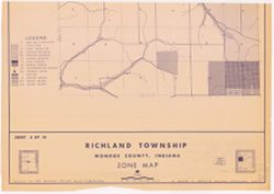
![[Monroe County, Indiana, existing use of land.] Sheet 5. Richland Township, Monroe County, Indiana, existing use of land](https://iiif.uits.iu.edu/iiif/2/2z10xt559%2Ffiles%2Fccd422c0-2373-4819-b6e9-60a0db266735/full/250,/0/default.jpg)
![[Monroe County, Indiana, existing use of land.] Sheet 9. Polk Township, Monroe County, Indiana, existing use of land](https://iiif.uits.iu.edu/iiif/2/th83n346m%2Ffiles%2F98da6cf6-258c-482d-aae7-a3cd05bc5456/full/250,/0/default.jpg)
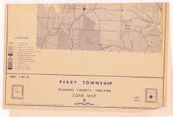
![[Monroe County, Indiana, existing use of land.] Sheet 3. Perry Township, Monroe County, Indiana, existing use of land](https://iiif.uits.iu.edu/iiif/2/v405tf204%2Ffiles%2Fbadb621b-741e-4e53-9deb-4d9093251dcd/full/250,/0/default.jpg)