
Search Constraints
You searched for:
Provenance
Part of Geological Survey (U.S.). Indiana 1:62,500.
Remove constraint Provenance: Part of Geological Survey (U.S.). Indiana 1:62,500.
« Previous |
111 - 119 of 119
|
Next »
Search Results
-
![Indiana-Illinois Princeton quadrangle [1922 reprint without vegetation]](https://iiif.uits.iu.edu/iiif/2/0r968719t%2Ffiles%2F75ec17c9-3877-4a76-8f1a-579970db193c/full/250,/0/default.jpg)
- Subject:
- Geographic Subject: Knox County (Ind.), Geographic Subject: Wabash County (Ill.), and Geographic Subject: Gibson County (Ind.)
- Creator:
- Goodlove, C. W., Geological Survey (U.S.), Renshawe, John H., and Hawkins, Geo. T. (George T.)
- Publisher:
- Geological Survey (U.S.)
- Date Created:
- 1922
- Identifier:
- VAC3073-M-01384
- Genre:
- 15 minute topographic maps, Topographic maps, and Quadrangle maps
- Geographic Location:
- Coordinates: W0874500 W0873000 N0383000 N0381500
- Related URL:
- Catalog URL: https://iucat.iu.edu/catalog/18413584
- Abstract:
- Jno. H. Renshawe, geographer in charge , control by Geo. T. Hawkins , topography by Chas. W. Goodlove. Filing title: Princeton, Ind.-Ill. Edition of 1903. Re...
- Call Number:
- G4090 s62 .G4 Princeton 1903 rep1922
- Caption:
- Imprint: Washington, D.C. : U.S. Geological Survey, 1922
- Physical Description:
- Scale: 1:62,500 and Dimensions: 45 x 42 cm or smaller
- Alternate Identifier:
- Title Control Number: a18413584
- Persistent URL:
- https://purl.dlib.indiana.edu/iudl/images/VAC3073/VAC3073-M-01384
- Provenance:
- Part of Geological Survey (U.S.). Indiana 1:62,500.
-
![Indiana-Kentucky Owensboro quadrangle [1925 reprint]](https://iiif.uits.iu.edu/iiif/2/nv936614b%2Ffiles%2F0065ee42-8514-4b9d-b077-6414175ea378/full/250,/0/default.jpg)
- Subject:
- Geographic Subject: Warrick County (Ind.), Geographic Subject: Daviess County (Ky.), and Geographic Subject: Spencer County (Ind.)
- Creator:
- Cooke, Chas. E. (Charles E.), Hawkins, Geo. T. (George T.), Renshawe, John H., and Geological Survey (U.S.)
- Publisher:
- Geological Survey (U.S.)
- Date Created:
- 1925
- Identifier:
- VAC3073-M-01374
- Genre:
- Topographic maps, Quadrangle maps, and 15 minute topographic maps
- Geographic Location:
- Coordinates: W0871500 W0870000 N0380000 N0374500
- Related URL:
- Catalog URL: https://iucat.iu.edu/catalog/18413576
- Abstract:
- John H. Renshaw, geographer in charge , control by George T. Hawkins , topography by Chas. E. Cooke. Filing title: Owensboro, Ind.-Ky. Edition of Nov. 1901. ...
- Call Number:
- G4090 s62 .G4 Owensboro 1901 rep 1925
- Caption:
- Imprint: Washington, D.C. : U.S. Geological Survey, 1925
- Physical Description:
- Dimensions: 45 x 42 cm or smaller and Scale: 1:62,500
- Alternate Identifier:
- Title Control Number: a18413576
- Persistent URL:
- https://purl.dlib.indiana.edu/iudl/images/VAC3073/VAC3073-M-01374
- Provenance:
- Part of Geological Survey (U.S.). Indiana 1:62,500.
-
![Indiana St. Meinrad quadrangle [1936 reprint]](https://iiif.uits.iu.edu/iiif/2/db78vg83w%2Ffiles%2Faed1f382-144b-48a5-81c6-0511f0a3ccf0/full/250,/0/default.jpg)
- Subject:
- Geographic Subject: Spencer County (Ind.), Geographic Subject: Dubois County (Ind.), and Geographic Subject: Perry County (Ind.)
- Creator:
- Goodlove, C. W., Renshawe, John H., Hawkins, Geo. T. (George T.), and Geological Survey (U.S.)
- Publisher:
- Geological Survey (U.S.)
- Date Created:
- 1936
- Identifier:
- VAC3073-M-01393
- Genre:
- Quadrangle maps, 15 minute topographic maps, and Topographic maps
- Geographic Location:
- Coordinates: W0870000 W0864500 N0381500 N0380000
- Related URL:
- Catalog URL: https://iucat.iu.edu/catalog/18413973
- Abstract:
- Jno. H. Renshawe, geographer in charge , control by Geo. T. Hawkins , topography by Chas. W. Goodlove , engraved Jan. 1903 by U.S.G.S. Edition of 1903. Poly...
- Call Number:
- G4090 s62 .G4 St. Meinrad 1903 rep1936
- Caption:
- Imprint: Washington, D.C. : U.S. Geological Survey, 1936
- Physical Description:
- Scale: 1:62,500 and Dimensions: 45 x 42 cm or smaller
- Alternate Identifier:
- Title Control Number: a18413973
- Persistent URL:
- https://purl.dlib.indiana.edu/iudl/images/VAC3073/VAC3073-M-01393
- Provenance:
- Part of Geological Survey (U.S.). Indiana 1:62,500.
-
![Indiana-Ohio, Winchester quadrangle [1918 printing]](https://iiif.uits.iu.edu/iiif/2/xw42pc314%2Ffiles%2F87f0e842-bedb-4ab3-a0e6-270a4e9f7c9a/full/250,/0/default.jpg)
- Subject:
- Geographic Subject: Darke County (Ohio), Geographic Subject: Randolph County (Ind.), and Geographic Subject: Wayne County (Ind.)
- Creator:
- Smith, Glenn S. (Glenn Shepard), Herron, W. H. (William Harrison), 1865-, Geological Survey (U.S.), Ohio. Division of Geological Survey, Harrison, R. L. (Top...
- Publisher:
- Geological Survey (U.S.)
- Date Created:
- 1918
- Identifier:
- VAC3073-M-01310
- Genre:
- 15 minute topographic maps, Quadrangle maps, and Topographic maps
- Geographic Location:
- Coordinates: W0850000 W0844500 N0401500 N0400000
- Related URL:
- Catalog URL: https://iucat.iu.edu/catalog/18416004
- Abstract:
- W.H. Herron, acting chief geogrpher , Glenn S. Smith, topographic engineer in charge , topography by R.L. Harrison and W.L. Miller , control by J.R. Ellis, J...
- Call Number:
- G4090 s62 .G4 Winchester 1918
- Caption:
- Imprint: [Washington, D.C.] : U.S. Geological Survey, [1918]
- Physical Description:
- Scale: 1:62,500 and Dimensions: 45 x 42 cm or smaller
- Alternate Identifier:
- Title Control Number: a18416004
- Persistent URL:
- https://purl.dlib.indiana.edu/iudl/images/VAC3073/VAC3073-M-01310
- Provenance:
- Part of Geological Survey (U.S.). Indiana 1:62,500.
-
![Illinois-Indiana Birds quadrangle : topography [1958 reprint]](https://iiif.uits.iu.edu/iiif/2/vt151n461%2Ffiles%2F8d479352-343d-4029-a644-fe61b614fa55/full/250,/0/default.jpg)
- Subject:
- Geographic Subject: Sullivan County (Ind.), Geographic Subject: Crawford County (Ill.), and Geographic Subject: Knox County (Ind.)
- Creator:
- U.S. Coast and Geodetic Survey, Herron, W. H. (William Harrison), 1865-, Marshall, R. B. (Robert Bradford), 1867-1949, Graff, Fred, Jr., United States. Army,...
- Publisher:
- Geological Survey (U.S.)
- Date Created:
- 1958
- Identifier:
- VAC3073-M-01317
- Genre:
- Quadrangle maps, Topographic maps, and 15 minute topographic maps
- Geographic Location:
- Coordinates: W0874500 W0873000 N0390000 N0384500
- Related URL:
- Catalog URL: https://iucat.iu.edu/catalog/18408528
- Abstract:
- R.B. Marshall, Chief Geographer , W.H. Herron, Geographer in charge , topography by F. Graff, Jr. , control by Corps of Engineers U.S. Army, U.S. Coast and G...
- Call Number:
- G4090 s62 .G4 Birds 1942 rep1958
- Caption:
- Imprint: Washington, D.C. : Interior--Geological Survey, 1958. Washington, D.C. : for sale by U.S. Geological Survey and Imprint: Urbana, Illinois : State Ge...
- Physical Description:
- Scale: 1:62,500 and Dimensions: 45 x 42 cm or smaller
- Alternate Identifier:
- Title Control Number: a18408528
- Persistent URL:
- https://purl.dlib.indiana.edu/iudl/images/VAC3073/VAC3073-M-01317
- Provenance:
- Part of Geological Survey (U.S.). Indiana 1:62,500.
-
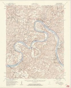
- Subject:
- Geographic Subject: Breckinridge County (Ky.), Geographic Subject: Perry County (Ind.), Geographic Subject: Harrison County (Ind.), Geographic Subject: Meade...
- Creator:
- United States. Army Map Service and Geological Survey (U.S.)
- Publisher:
- Geological Survey (U.S.)
- Date Created:
- 1959
- Identifier:
- VAC3073-M-01312
- Genre:
- Topographic maps, Quadrangle maps, and 15 minute topographic maps
- Geographic Location:
- Coordinates: W0863000 W0861500 N0381500 N0380000
- Related URL:
- Catalog URL: https://iucat.iu.edu/catalog/18406357
- Abstract:
- Mapped by the Geological Survey and the Army Map Service. Filing title: Alton, Ind.--Ky. Polyconic projection. Relief shown by contours and spot heights. Inc...
- Call Number:
- G4090 s62 .G4 Alton 1950 R1959
- Caption:
- Imprint: Washington, D.C. : Interior--Geological Survey, 1959.
- Physical Description:
- Scale: 1:62,500 and Dimensions: 45 x 42 cm or smaller
- Alternate Identifier:
- Title Control Number: a18406357
- Persistent URL:
- https://purl.dlib.indiana.edu/iudl/images/VAC3073/VAC3073-M-01312
- Provenance:
- Part of Geological Survey (U.S.). Indiana 1:62,500.
-
![Indiana Bloomington quadrangle [1946 reprint with 21 indexed cave locations]](https://iiif.uits.iu.edu/iiif/2/dz011t645%2Ffiles%2Fbb3033b6-3144-4af2-a6c7-a5710771ff06/full/250,/0/default.jpg)
- Subject:
- Geographic Subject: Owen County (Ind.), Geographic Subject: Monroe County (Ind.), Topical Subject: Caves, and Geographic Subject: Greene County (Ind.)
- Creator:
- Griffin, W. H. (William H.), Marshall, R. B. (Robert Bradford), 1867-1949, Sadler, C. L., and Herron, W. H. (William Harrison), 1865-
- Publisher:
- Geological Survey (U.S.)
- Date Created:
- 1946
- Identifier:
- VAC3073-M-01218
- Genre:
- Topographic maps, Quadrangle maps, and 15 minute topographic maps
- Geographic Location:
- Coordinates: W0864500 W0863000 N0391500 N0390000
- Related URL:
- Catalog URL: https://iucat.iu.edu/catalog/18406221
- Abstract:
- R. B. Marshall, chief geographer , W. H. Herron, Geographer in charge , topography by W. H. Griffin and C. L. Sandler , Control by J. R. Ellis and C. H. Semp...
- Call Number:
- G4090 s62 .G4 Bloomington 1910 R1946
- Caption:
- Imprint: [Washington, D.C.] : United States, Department of the Interior, Geological Survey, [1946]
- Physical Description:
- Scale: 1:62,500 and Dimensions: 45 x 42 cm or smaller
- Alternate Identifier:
- Title Control Number: a18406221
- Persistent URL:
- https://purl.dlib.indiana.edu/iudl/images/VAC3073/VAC3073-M-01218
- Provenance:
- Part of Geological Survey (U.S.). Indiana 1:62,500.
-
![Indiana Bloomington quadrangle [1948 reprint]](https://iiif.uits.iu.edu/iiif/2/2j62t788s%2Ffiles%2F57d817cb-ee47-4ed5-9f38-24d8a93dcb0b/full/250,/0/default.jpg)
- Subject:
- Geographic Subject: Owen County (Ind.), Geographic Subject: Greene County (Ind.), and Geographic Subject: Monroe County (Ind.)
- Creator:
- Marshall, R. B. (Robert Bradford), 1867-1949, Herron, W. H. (William Harrison), 1865-, Griffin, W. H. (William H.), and Sadler, C. L.
- Publisher:
- Geological Survey (U.S.)
- Date Created:
- 1948
- Identifier:
- VAC3073-M-01219
- Genre:
- Topographic maps, 15 minute topographic maps, and Quadrangle maps
- Geographic Location:
- Coordinates: W0880000 W0844500 N0414500 N0375200
- Related URL:
- Catalog URL: https://iucat.iu.edu/catalog/18406221
- Abstract:
- R. B. Marshall, chief geographer , W. H. Herron, Geographer in charge , topography by W. H. Griffin and C. L. Sandler , Control by J. R. Ellis and C. H. Semp...
- Call Number:
- G4090 s62 .G4 Bloomington 1910 R1948
- Caption:
- Imprint: [Washington, D.C.] : United States, Department of the Interior, Geological Survey, [1948]
- Physical Description:
- Dimensions: 45 x 42 cm or smaller and Scale: 1:62,500
- Alternate Identifier:
- Title Control Number: a18406221
- Persistent URL:
- https://purl.dlib.indiana.edu/iudl/images/VAC3073/VAC3073-M-01219
- Provenance:
- Part of Geological Survey (U.S.). Indiana 1:62,500.
-
![Indiana Bloomington quadrangle [1946 reprint]](https://iiif.uits.iu.edu/iiif/2/qj72qc04t%2Ffiles%2F069e9c1e-7c2e-4931-8df9-5ba99812cae2/full/250,/0/default.jpg)
- Subject:
- Geographic Subject: Monroe County (Ind.), Geographic Subject: Owen County (Ind.), and Geographic Subject: Greene County (Ind.)
- Creator:
- Griffin, W. H. (William H.), Marshall, R. B. (Robert Bradford), 1867-1949, Herron, W. H. (William Harrison), 1865-, and Sadler, C. L.
- Publisher:
- Geological Survey (U.S.)
- Date Created:
- 1946
- Identifier:
- VAC3073-M-01295
- Genre:
- 15 minute topographic maps, Topographic maps, and Quadrangle maps
- Geographic Location:
- Coordinates: W0864500 W0863000 N0391500 N0390000
- Related URL:
- Catalog URL: https://iucat.iu.edu/catalog/18406221
- Abstract:
- R. B. Marshall, chief geographer , W. H. Herron, Geographer in charge , topography by W. H. Griffin and C. L. Sandler , Control by J. R. Ellis and C. H. Semp...
- Call Number:
- G4090 s62 .G4 Bloomington 1910 R1946
- Caption:
- Imprint: [Washington, D.C.] : United States, Department of the Interior, Geological Survey, [1946]
- Physical Description:
- Scale: 1:62,500 and Dimensions: 45 x 42 cm or smaller
- Alternate Identifier:
- Title Control Number: a18406221
- Persistent URL:
- https://purl.dlib.indiana.edu/iudl/images/VAC3073/VAC3073-M-01295
- Provenance:
- Part of Geological Survey (U.S.). Indiana 1:62,500.
