
Search Constraints
You searched for:
Type
Image
Remove constraint Type: Image
Provenance
34th Annual Report (1909) / Indiana. Department of Geology and Natural Resources.
Remove constraint Provenance: 34th Annual Report (1909) / Indiana. Department of Geology and Natural Resources.
« Previous |
1 - 10 of 11
|
Next »
Search Results
-
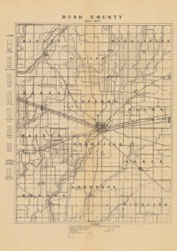
- Subject:
- Topical Subject: Soils and Geographic Subject: Rush County (Ind.)
- Creator:
- Indiana. Department of Geology and Natural Resources
- Publisher:
- Indiana. Department of Geology and Natural Resources
- Date Created:
- 1910
- Identifier:
- VAC3073-M-00995
- Genre:
- Thematic maps
- Geographic Location:
- Coordinates: W0853800 W0851751 N0394715 N0392708
- Related URL:
- Catalog URL: https://iucat.iu.edu/catalog/16124399
- Abstract:
- Shows railroads, dirt roads, and gravel roads. Includes notes on general topography. Detached from: A soil survey of Randolph, Wayne, Henry, Rush, Fayette...
- Call Number:
- G4093.R8J3 1909 .I53
- Caption:
- Imprint: [Indianapolis] : [Indiana Department of Geology and Natural Resources], [1910]
- Physical Description:
- Scale: 1:126,720 and Dimensions: 30 x 23 cm
- Alternate Identifier:
- Alternate ID: 390726IP and Title Control Number: a16124399
- Persistent URL:
- https://purl.dlib.indiana.edu/iudl/images/VAC3073/VAC3073-M-00995
- Provenance:
- 34th Annual Report (1909) / Indiana. Department of Geology and Natural Resources.
-
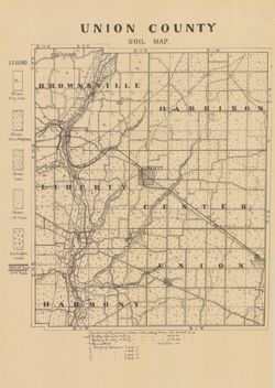
- Subject:
- Topical Subject: Soils and Geographic Subject: Union County (Ind.)
- Creator:
- Indiana. Department of Geology and Natural Resources
- Publisher:
- Indiana. Department of Geology and Natural Resources
- Date Created:
- 1910
- Identifier:
- VAC3073-M-00859
- Genre:
- Thematic maps
- Geographic Location:
- Coordinates: W0850210 W0844851 N0394345 N0393119
- Related URL:
- Catalog URL: https://iucat.iu.edu/catalog/16124317
- Abstract:
- Shows railroads, dirt roads, and gravel roads. Includes notes on general topography. Detached from: A soil survey of Randolph, Wayne, Henry, Rush, Fayette...
- Call Number:
- G4093.U5J3 1909 .I53
- Caption:
- Imprint: [Indianapolis] : [Indiana Department of Geology and Natural Resources], [1910]
- Physical Description:
- Dimensions: 25 x 21 cm and Scale: Approximately 1:95,000
- Alternate Identifier:
- Title Control Number: a16124317 and Alternate ID: 390726IP
- Persistent URL:
- https://purl.dlib.indiana.edu/iudl/images/VAC3073/VAC3073-M-00859
- Provenance:
- 34th Annual Report (1909) / Indiana. Department of Geology and Natural Resources.
-
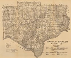
- Subject:
- Geographic Subject: Spencer County (Ind.), Geographic Subject: Warrick County (Ind.), and Topical Subject: Soils
- Creator:
- Shannon, C. W. (Charles William), 1879-1934
- Publisher:
- Indiana. Department of Geology and Natural Resources
- Date Created:
- 1910
- Identifier:
- VAC3073-M-00654
- Genre:
- Thematic maps
- Geographic Location:
- Coordinates: W0872823 W0864559 N0381446 N0374653
- Related URL:
- Catalog URL: https://iucat.iu.edu/catalog/16123910
- Abstract:
- Shows public roads and railroads. Detached from: A soil survey of Vanderburgh, Gibson, and Pike, and parts of Warrick and Spencer counties / Chas. W. Shan...
- Call Number:
- G4093.S5J3 1909 .S5
- Caption:
- Imprint: [Indianapolis] : [Indiana Department of Geology and Natural Resources], [1910]
- Physical Description:
- Dimensions: 44 x 52 cm and Scale: Approximately 1:126,720
- Alternate Identifier:
- Title Control Number: a16123910 and Alternate ID: 390726IP
- Persistent URL:
- https://purl.dlib.indiana.edu/iudl/images/VAC3073/VAC3073-M-00654
- Provenance:
- 34th Annual Report (1909) / Indiana. Department of Geology and Natural Resources.
-
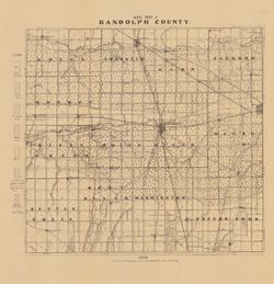
- Subject:
- Topical Subject: Soils and Geographic Subject: Randolph County (Ind.)
- Creator:
- Indiana. Department of Geology and Natural Resources
- Publisher:
- [Indiana Department of Geology and Natural Resources]
- Date Created:
- 1910
- Identifier:
- VAC3073-M-00373
- Genre:
- Thematic maps
- Geographic Location:
- Coordinates: W0851307 W0844813 N0401836 N0400014
- Related URL:
- Catalog URL: https://iucat.iu.edu/catalog/16124681
- Abstract:
- Shows railroads and public roads. Includes notes on general topography. Detached from: A soil survey of Randolph, Wayne, Henry, Rush, Fayette, Union and ...
- Call Number:
- G4093.R3J3 1909 .I53
- Caption:
- Imprint: [Indianapolis] : [Indiana Department of Geology and Natural Resources], [1910]
- Physical Description:
- Dimensions: 27 x 29 cm and Scale: Approximately 1:126,720
- Alternate Identifier:
- Title Control Number: a16124681 and Alternate ID: 390726IP
- Persistent URL:
- https://purl.dlib.indiana.edu/iudl/images/VAC3073/VAC3073-M-00373
- Provenance:
- 34th Annual Report (1909) / Indiana. Department of Geology and Natural Resources.
-
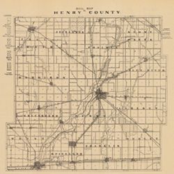
- Subject:
- Geographic Subject: Henry County (Ind.) and Topical Subject: Soils
- Creator:
- Indiana. Department of Geology and Natural Resources
- Publisher:
- [Indiana Dept. of Geology and Natural Resources]
- Date Created:
- 1910
- Identifier:
- VAC3073-M-00335
- Genre:
- Thematic maps
- Geographic Location:
- Coordinates: W0853549 W0851201 N0400437 N0394711
- Related URL:
- Catalog URL: https://iucat.iu.edu/catalog/16124410
- Abstract:
- Shows roads, railroads and traction lines. Detached from: A soil survey of Randolph, Wayne, Henry, Rush, Fayette, Union and Franklin counties / Arthur E. ...
- Call Number:
- G4093.H6J3 1909 .I53
- Caption:
- Imprint: [Indianapolis] : [Indiana Dept. of Geology and Natural Resources], [1910]
- Physical Description:
- Dimensions: 26 x 27 cm and Scale: Approximately 1:126,720
- Alternate Identifier:
- Title Control Number: a16124410 and Alternate ID: 390726IP
- Persistent URL:
- https://purl.dlib.indiana.edu/iudl/images/VAC3073/VAC3073-M-00335
- Provenance:
- 34th Annual Report (1909) / Indiana. Department of Geology and Natural Resources.
-
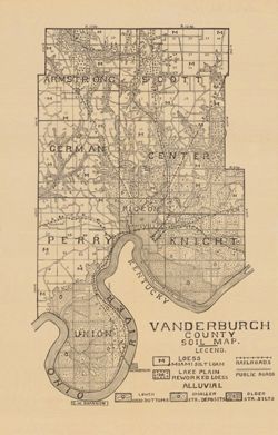
- Subject:
- Topical Subject: Soils and Geographic Subject: Vanderburgh County (Ind.)
- Creator:
- Shannon, C. W. (Charles William), 1879-1934
- Publisher:
- Indiana. Department of Geology and Natural Resources
- Date Created:
- 1910
- Identifier:
- VAC3073-M-00292
- Genre:
- Thematic maps
- Geographic Location:
- Coordinates: W0874202 W0872657 N0381006 N0374932
- Related URL:
- Catalog URL: https://iucat.iu.edu/catalog/16123565
- Abstract:
- Shows railroads and public roads. Detached from: A soil survey of Vanderburgh, Gibson, and Pike, and parts of Warrick and Spencer counties / Chas. W. Shan...
- Call Number:
- G4093.V3J3 1909 .S5
- Caption:
- Imprint: [Indianapolis] : [Indiana Department of Geology and Natural Resources], [1910]
- Physical Description:
- Dimensions: 37 x 24 cm and Scale: Approximately 1:126,720
- Alternate Identifier:
- Alternate ID: 390726IP and Title Control Number: a16123565
- Persistent URL:
- https://purl.dlib.indiana.edu/iudl/images/VAC3073/VAC3073-M-00292
- Provenance:
- 34th Annual Report (1909) / Indiana. Department of Geology and Natural Resources.
-

- Subject:
- Geographic Subject: Fayette County (Ind.) and Topical Subject: Soils
- Creator:
- Indiana. Department of Geology and Natural Resources
- Publisher:
- [Indiana Dept. of Geology and Natural Resources]
- Date Created:
- 1910
- Identifier:
- VAC3073-M-00266
- Genre:
- Thematic maps
- Geographic Location:
- Coordinates: W0851800 W0850206 N0394718 N0393134
- Related URL:
- Catalog URL: https://iucat.iu.edu/catalog/16091039
- Abstract:
- Also shows dirt roads, gravel roads, and railroads. Legend includes notes on general topography. Detached from: A soil survey of Randolph, Wayne, Henry, R...
- Call Number:
- G4093.F3J3 1909 .I53
- Caption:
- Imprint: [Indianapolis] : [Indiana Dept. of Geology and Natural Resources], [1910]
- Physical Description:
- Scale: Approximately 1:95,000 and Dimensions: 31 x 24 cm
- Alternate Identifier:
- Title Control Number: a16091039 and Alternate ID: 390726IP
- Persistent URL:
- https://purl.dlib.indiana.edu/iudl/images/VAC3073/VAC3073-M-00266
- Provenance:
- 34th Annual Report (1909) / Indiana. Department of Geology and Natural Resources.
-
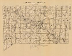
- Subject:
- Topical Subject: Soils and Geographic Subject: Franklin County (Ind.)
- Creator:
- Indiana. Department of Geology and Natural Resources
- Publisher:
- [Indiana Department of Geology and Natural Resources]
- Date Created:
- 1910
- Identifier:
- VAC3073-M-00176
- Genre:
- Thematic maps
- Geographic Location:
- Coordinates: W0851755 W0844854 N0393139 N0391608
- Related URL:
- Catalog URL: https://iucat.iu.edu/catalog/16095773
- Abstract:
- Also shows railroads, improved roads and dirt roads. Legend includes notes on general topography. Detached from: A soil survey of Randolph, Wayne, Henry, ...
- Call Number:
- G4093.F7J3 1909 .I53
- Caption:
- Imprint: [Indianapolis] : [Indiana Department of Geology and Natural Resources], [1910]
- Physical Description:
- Scale: Approximately 1:126,720 and Dimensions: 23 x 34 cm
- Alternate Identifier:
- Title Control Number: a16095773 and Alternate ID: 390726IP
- Persistent URL:
- https://purl.dlib.indiana.edu/iudl/images/VAC3073/VAC3073-M-00176
- Provenance:
- 34th Annual Report (1909) / Indiana. Department of Geology and Natural Resources.
-
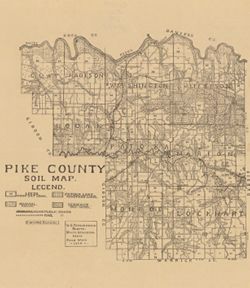
- Subject:
- Geographic Subject: Pike County (Ind.) and Topical Subject: Soils
- Creator:
- Shannon, M. E. and Shannon, C. W. (Charles William), 1879-1934
- Publisher:
- Indiana. Department of Geology and Natural Resources
- Date Created:
- 1910
- Identifier:
- VAC3073-M-00173
- Genre:
- Thematic maps
- Geographic Location:
- Coordinates: W0872746 W0870419 N0383308 N0381351
- Related URL:
- Catalog URL: https://iucat.iu.edu/catalog/16123837
- Abstract:
- Shows railroads and 3 classes of roads. "U.S. topographic sheets, state geological maps, field work 1909." Detached from: A soil survey of Vande...
- Call Number:
- G4093.P4J3 1909 .S5
- Caption:
- Imprint: [Indianapolis] : [Indiana Department of Geology and Natural Resources], [1910]
- Physical Description:
- Scale: Approximately 1:126,720 and Dimensions: 37 x 32 cm
- Alternate Identifier:
- Title Control Number: a16123837 and Alternate ID: 390726IP
- Persistent URL:
- https://purl.dlib.indiana.edu/iudl/images/VAC3073/VAC3073-M-00173
- Provenance:
- 34th Annual Report (1909) / Indiana. Department of Geology and Natural Resources.
-
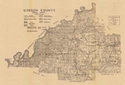
- Subject:
- Topical Subject: Soils and Geographic Subject: Gibson County (Ind.)
- Creator:
- Shannon, M. E. and Shannon, C. W. (Charles William), 1879-1934
- Publisher:
- Indiana. Department of Geology and Natural Resources
- Date Created:
- 1910
- Identifier:
- VAC3073-M-00029
- Genre:
- Thematic maps
- Geographic Location:
- Coordinates: W0875912 W0871858 N0383155 N0380956
- Related URL:
- Catalog URL: https://iucat.iu.edu/catalog/16091035
- Abstract:
- Shows public roads and railroads. Detached from: A soil survey of Randolph, Wayne, Henry, Rush, Fayette, Union and Franklin counties / Arthur E. Taylor. I...
- Call Number:
- G4093.G5J3 1909 .S5
- Caption:
- Imprint: [Indianapolis] : [Indiana Department of Geology and Natural Resources], [1910]
- Physical Description:
- Dimensions: 37 x 54 cm and Scale: Approximately 1:126,720
- Alternate Identifier:
- Title Control Number: a16091035 and Alternate ID: 390726IP
- Persistent URL:
- https://purl.dlib.indiana.edu/iudl/images/VAC3073/VAC3073-M-00029
- Provenance:
- 34th Annual Report (1909) / Indiana. Department of Geology and Natural Resources.
