
Search Constraints
You searched for:
Date Created
1941
Remove constraint Date Created: 1941
Provenance
CIA Map Branch -- Received
Remove constraint Provenance: CIA Map Branch -- Received
« Previous |
1 - 10 of 45
|
Next »
Search Results
-
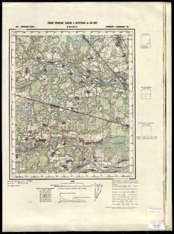
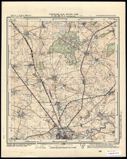
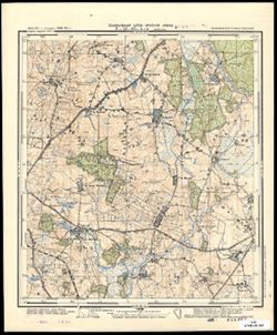
- Description:
- 1938
- Subject:
- Topical Subject: Soviet Union, Topical Subject: Maps, and Geographic Subject: Boykovo
- Publisher:
- Главное управление геодезии и картографии при СНК СССР
- Language:
- Russian
- Date Created:
- 1941
- Identifier:
- VAC9619-003447
- Genre:
- Military Maps and Topographic Maps
- Geographic Location:
- Coordinates: 56.833, 35.5, 57, 35.75
- Related URL:
- Download GeoTIFF: https://drive.google.com/file/d/1BdYV5wb7st8BaWASg6uGiYw9j6iroPEA/view?usp=sharing and Catalog URL: http://iucat.iu.edu/catalog/5020131
- Abstract:
- Modern area represented: Бойково (Boykovo), Tverskaya oblast, Russia
- Call Number:
- GM G7000 s50 .S68 sheet O-36-120-A
- City:
- Бойково (Boykovo)
- Copyright Holder:
- No Copyright - United States
- Country:
- СССР (USSR)
- State/Province:
- Медновский район (Mednovsky district), Калининский район (Kalininsky district), and Калининская область (Kalinin oblast)
- Physical Description:
- Scale: 1:50,000
- Persistent URL:
- http://purl.dlib.indiana.edu/iudl/images/VAC9619/VAC9619-003447
- Provenance:
- CIA Map Branch -- Received
-
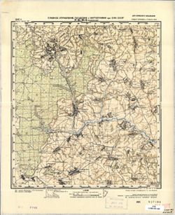
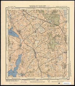
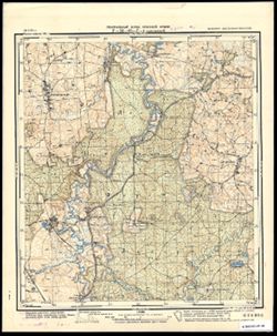
- Description:
- 1940
- Subject:
- Topical Subject: Maps, Topical Subject: Soviet Union, and Geographic Subject: Kireykovo
- Publisher:
- Главное Управление Геодезии и Картографии при СНК СССР
- Language:
- Russian
- Date Created:
- 1941
- Identifier:
- VAC9619-001474
- Genre:
- Military Maps and Topographic Maps
- Geographic Location:
- Coordinates: 53.5, 35.75, 53.6667, 36
- Related URL:
- Download GeoTIFF: https://drive.google.com/open?id=1R9kpsNoGm2X6GcH_F6iUnZS863OTyOEz and Catalog URL: http://iucat.iu.edu/catalog/5020131
- Abstract:
- Modern area represented: Kireykovo, Kaluga, Russia
- Call Number:
- G7000 s50 .S68 sheet N-36-96-Б
- Caption:
- Для служебного пользования
- City:
- Кирейково (Kireykovo)
- Copyright Holder:
- No Copyright - United States
- Country:
- СССР (USSR)
- State/Province:
- Орловская область (Oryol oblast), РСФСР (RSFSR), and Тульская область (Tula oblast)
- Physical Description:
- Scale: 1:50,000
- Persistent URL:
- http://purl.dlib.indiana.edu/iudl/images/VAC9619/VAC9619-001474
- Provenance:
- CIA Map Branch -- Received
-
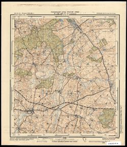
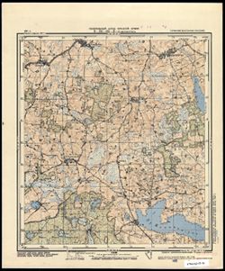
- Description:
- 1940
- Subject:
- Geographic Subject: Vesniny, Topical Subject: Maps, and Topical Subject: Soviet Union
- Publisher:
- Главное Управление Геодезии и Картографии при СНК СССР
- Language:
- Russian
- Date Created:
- 1941
- Identifier:
- VAC9619-001470
- Genre:
- Military Maps and Topographic Maps
- Geographic Location:
- Coordinates: 53.5, 35.25, 53.6667, 35.5
- Related URL:
- Catalog URL: http://iucat.iu.edu/catalog/5020131 and Download GeoTIFF: https://drive.google.com/open?id=1h4jB7_zufkpu5_-Zl-G434kI4Z-2knW_
- Abstract:
- Modern area represented: Vesniny, Kaluga, Russia
- Call Number:
- G7000 s50 .S68 sheet N-36-95-B
- City:
- Веснины (Vesniny)
- Copyright Holder:
- No Copyright - United States
- Country:
- СССР (USSR)
- State/Province:
- Орловская область (Oryol oblast) and РСФСР (RSFSR)
- Physical Description:
- Scale: 1:50,000
- Persistent URL:
- http://purl.dlib.indiana.edu/iudl/images/VAC9619/VAC9619-001470
- Provenance:
- CIA Map Branch -- Received
-
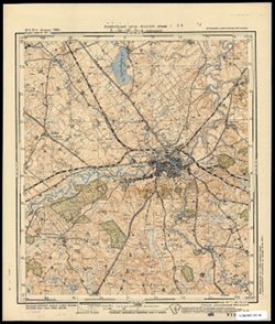
- Subject:
- Geographic Subject: Galiny, Topical Subject: Soviet Union, and Topical Subject: Maps
- Publisher:
- Генеральный штаб Красной Армии
- Language:
- Russian
- Date Created:
- 1941
- Identifier:
- VAC9619-003814
- Genre:
- Military Maps and Topographic Maps
- Geographic Location:
- Coordinates: 54.083, 20.75, 54.1667, 20.875
- Related URL:
- Download GeoTIFF: https://drive.google.com/file/d/1uq3LcNUQMze4weSSvkbDPn_sSpKayldj/view?usp=sharing and Catalog URL: https://iucat.iu.edu/catalog/14701157
- Abstract:
- Modern area represented: Galiny, Poland
- Call Number:
- G7063.K2 s25 .S6 sheet N-34-66-D-а
- City:
- Галлинген (Gallingen)
- Copyright Holder:
- No Copyright - United States
- Country:
- Германия (Восточная Пруссия) (Germany (East Prussia))
- Physical Description:
- Scale: 1:25,000
- Persistent URL:
- http://purl.dlib.indiana.edu/iudl/images/VAC9619/VAC9619-003814
- Provenance:
- CIA Map Branch -- Received
-
- Description:
- 1913
- Subject:
- Topical Subject: Soviet Union, Geographic Subject: Bartoszyce, and Topical Subject: Maps
- Publisher:
- Генеральный штаб Красной Армии
- Language:
- Russian
- Date Created:
- 1941
- Identifier:
- VAC9619-003806
- Genre:
- Military Maps and Topographic Maps
- Geographic Location:
- Coordinates: 54.25, 20.75, 54.333, 20.875
- Related URL:
- Download GeoTIFF: https://drive.google.com/file/d/1QzOGgwiENbaqrLhOT4VC2tvPpw3Rr0uG/view?usp=sharing and Catalog URL: https://iucat.iu.edu/catalog/14701157
- Abstract:
- Modern area represented: Bartoszyce, Poland (North side of the city)
- Call Number:
- G7063.K2 s25 .S6 sheet N-34-66-B-а
- City:
- Бартенштайн (Bartenstein)
- Copyright Holder:
- No Copyright - United States
- Country:
- Германия (Восточная Пруссия) (Germany (East Prussia))
- Physical Description:
- Scale: 1:25,000
- Persistent URL:
- http://purl.dlib.indiana.edu/iudl/images/VAC9619/VAC9619-003806
- Provenance:
- CIA Map Branch -- Received
-
- Subject:
- Geographic Subject: Żegoty, Topical Subject: Soviet Union, and Topical Subject: Maps
- Publisher:
- Генеральный штаб Красной Армии
- Language:
- Russian
- Date Created:
- 1941
- Identifier:
- VAC9619-003813
- Genre:
- Military Maps and Topographic Maps
- Geographic Location:
- Coordinates: 54, 20.625, 54.083, 20.75
- Related URL:
- Catalog URL: https://iucat.iu.edu/catalog/14701157 and Download GeoTIFF: https://drive.google.com/file/d/1kUJgKocZwo6uXi5BKVXnR6Bg0NzyhBgV/view?usp=sharing
- Abstract:
- Modern area represented: Żegoty, Poland
- Call Number:
- G7063.K2 s25 .S6 sheet N-34-66-C-d
- City:
- Зигфридсвальде (Siegfriedswalde)
- Copyright Holder:
- No Copyright - United States
- Country:
- Германия (Восточная Пруссия) (Germany (East Prussia))
- Physical Description:
- Scale: 1:25,000
- Persistent URL:
- http://purl.dlib.indiana.edu/iudl/images/VAC9619/VAC9619-003813
- Provenance:
- CIA Map Branch -- Received
-
- Subject:
- Topical Subject: Soviet Union, Geographic Subject: Kłębowo, and Topical Subject: Maps
- Publisher:
- Генеральный штаб Красной Армии
- Language:
- Russian
- Date Created:
- 1941
- Identifier:
- VAC9619-003812
- Genre:
- Topographic Maps and Military Maps
- Geographic Location:
- Coordinates: 54, 20.5, 54.083, 20.625
- Related URL:
- Download GeoTIFF: https://drive.google.com/file/d/1XgTFZHiM82btNnNy2kZm1YCq1_uyTWD2/view?usp=sharing and Catalog URL: https://iucat.iu.edu/catalog/14701157
- Abstract:
- Modern area represented: Kłębowo, Poland
- Call Number:
- G7063.K2 s25 .S6 sheet N-34-66-C-c
- City:
- Вернегиттен (Wernegitten)
- Copyright Holder:
- No Copyright - United States
- Country:
- Германия (Восточная Пруссия) (Germany (East Prussia))
- Physical Description:
- Scale: 1:25,000
- Persistent URL:
- http://purl.dlib.indiana.edu/iudl/images/VAC9619/VAC9619-003812
- Provenance:
- CIA Map Branch -- Received
-
- Subject:
- Topical Subject: Maps, Topical Subject: Soviet Union, and Geographic Subject: Lidzbark Warmiński
- Publisher:
- Генеральный штаб Красной Армии
- Language:
- Russian
- Date Created:
- 1941
- Identifier:
- VAC9619-003810
- Genre:
- Topographic Maps and Military Maps
- Geographic Location:
- Coordinates: 54.083, 20.5, 54.1667, 20.625
- Related URL:
- Catalog URL: https://iucat.iu.edu/catalog/14701157 and Download GeoTIFF: https://drive.google.com/file/d/1sDYP-3i5fljh-WRIC1yz3K_huEByjd7c/view?usp=sharing
- Abstract:
- Modern area represented: Lidzbark Warmiński, Poland
- Call Number:
- G7063.K2 s25 .S6 sheet N-34-66-C-а
- City:
- Хайльсберг (Heilsberg)
- Copyright Holder:
- No Copyright - United States
- Country:
- Германия (Восточная Пруссия) (Germany (East Prussia))
- Physical Description:
- Scale: 1:25,000
- Persistent URL:
- http://purl.dlib.indiana.edu/iudl/images/VAC9619/VAC9619-003810
- Provenance:
- CIA Map Branch -- Received
-
- Subject:
- Topical Subject: Maps, Topical Subject: Soviet Union, and Geographic Subject: Piasty Wielkie
- Publisher:
- Генеральный штаб Красной Армии
- Language:
- Russian
- Date Created:
- 1941
- Identifier:
- VAC9619-003803
- Genre:
- Military Maps and Topographic Maps
- Geographic Location:
- Coordinates: 54.25, 20.5, 54.333, 20.625
- Related URL:
- Download GeoTIFF: https://drive.google.com/file/d/1FSOtOsv2Jn6MeknZzhKIDWNmtC1mn-ok/view?usp=sharing and Catalog URL: https://iucat.iu.edu/catalog/14701157
- Abstract:
- Modern area represented: Piasty Wielkie, Poland
- Call Number:
- G7063.K2 s25 .S6 sheet N-34-66-A-а
- City:
- Пайстен (Peisten)
- Copyright Holder:
- No Copyright - United States
- Country:
- Германия (Восточная Пруссия) (Germany (East Prussia))
- Physical Description:
- Scale: 1:25,000
- Persistent URL:
- http://purl.dlib.indiana.edu/iudl/images/VAC9619/VAC9619-003803
- Provenance:
- CIA Map Branch -- Received
-
- Subject:
- Topical Subject: Soviet Union, Topical Subject: Maps, and Geographic Subject: Smolajny
- Publisher:
- Генеральный штаб Красной Армии
- Language:
- Russian
- Date Created:
- 1941
- Identifier:
- VAC9619-003802
- Genre:
- Topographic Maps and Military Maps
- Geographic Location:
- Coordinates: 54, 20.375, 54.083, 20.5
- Related URL:
- Download GeoTIFF: https://drive.google.com/file/d/1tYsmv94v_ZjmWiabEMtA5NTbqaONylyp/view?usp=sharing and Catalog URL: https://iucat.iu.edu/catalog/14701157
- Abstract:
- Modern area represented: Smolajny, Poland
- Call Number:
- G7063.K2 s25 .S6 sheet N-34-65-D-d
- City:
- Шмолайнен (Schmolainen)
- Copyright Holder:
- No Copyright - United States
- Country:
- Германия (Восточная Пруссия) (Germany (East Prussia))
- Physical Description:
- Scale: 1:25,000
- Persistent URL:
- http://purl.dlib.indiana.edu/iudl/images/VAC9619/VAC9619-003802
- Provenance:
- CIA Map Branch -- Received
