
Search Constraints
You searched for:
State/Province
Украинская ССР (Ukrainian Soviet Socialist Republic)
Remove constraint State/Province: Украинская ССР (Ukrainian Soviet Socialist Republic)
« Previous |
1 - 20 of 566
|
Next »
Search Results
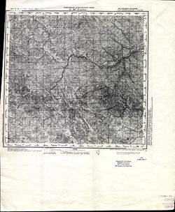
-
- Description:
- 1875
- Subject:
- Geographic Subject: Volintiri, Topical Subject: Soviet Union, and Topical Subject: Maps
- Publisher:
- Генеральный штаб РККА
- Language:
- Russian
- Date Created:
- 1940
- Identifier:
- VAC9619-001581
- Genre:
- Topographic Maps and Military Maps
- Geographic Location:
- Coordinates: 46.3333, 29.5, 46.6667, 30
- Related URL:
- Download GeoTIFF: https://drive.google.com/open?id=1yjBpyWEhLGUL0b_IOaIHHjcBR0P7r7Hi and Catalog URL: https://iucat.iu.edu/catalog/5020129
- Abstract:
- Modern area represented: Volintiri, Ștefan Vodă district, Moldova
- Call Number:
- G7000 s100 .S7 sheet L-35-60
- Caption:
- Не подлежит оглашению
- City:
- Волинтирь (Volintiri)
- Copyright Holder:
- No Copyright - United States
- Country:
- СССР (USSR)
- State/Province:
- Украинская ССР (Ukrainian Soviet Socialist Republic), Одесская область (Odessa oblast), Молдавская АССР (Moldavian Autonomous Soviet Socialist Republic), and...
- Physical Description:
- Scale: 1:100,000
- Persistent URL:
- http://purl.dlib.indiana.edu/iudl/images/VAC9619/VAC9619-001581
- Provenance:
- Library of Congress Geography & Map Division, Atlasblatt, DMA Topographic Center, Army Map Service Library, OMAHA
-
- Description:
- 1930
- Subject:
- Topical Subject: Maps, Topical Subject: Soviet Union, and Geographic Subject: Kamenskiy Khutor
- Publisher:
- Управление военных топографов
- Language:
- Russian
- Identifier:
- VAC9619-001580
- Genre:
- Topographic Maps and Military Maps
- Geographic Location:
- Coordinates: 52, 32.25, 52.1667, 32.5
- Related URL:
- Catalog URL: http://iucat.iu.edu/catalog/5020131 and Download GeoTIFF: https://drive.google.com/open?id=1F40ViE0yDvGViIOC-bOSCTmjsYKUPP0M
- Abstract:
- Modern area represented: Kamenskiy Khutor, Bryansk oblast, Russia
- Call Number:
- G7000 s50 .S68 sheet N-36-137-D
- Caption:
- Не подлежит оглашению
- City:
- Каменский Хутор (Kamenskiy Khutor)
- Copyright Holder:
- No Copyright - United States
- Country:
- СССР (USSR)
- State/Province:
- Западная область (Western oblast), РСФСР (RSFSR), and Украинская ССР (Ukrainian Soviet Socialist Republic)
- Physical Description:
- Scale: 1:50,000
- Persistent URL:
- http://purl.dlib.indiana.edu/iudl/images/VAC9619/VAC9619-001580
- Provenance:
- M. I. Map Library, Atlasblatt
-
- Description:
- 1930
- Subject:
- Topical Subject: Maps, Geographic Subject: Novyy Ropsk, and Topical Subject: Soviet Union
- Publisher:
- Управление военных топографов
- Language:
- Russian
- Identifier:
- VAC9619-001578
- Genre:
- Topographic Maps and Military Maps
- Geographic Location:
- Coordinates: 52.1667, 32.25, 52.3333, 32.5
- Related URL:
- Catalog URL: http://iucat.iu.edu/catalog/5020131 and Download GeoTIFF: https://drive.google.com/open?id=13t64kb76EHxk27fhUSp4LHrgQc7MI4jm
- Abstract:
- Modern area represented: Novyy Ropsk, Bryansk oblast, Russia
- Call Number:
- G7000 s50 .S68 sheet N-36-137-Б
- Caption:
- Не подлежит оглашению
- City:
- М. Нов. Ропск (Novyy Ropsk)
- Copyright Holder:
- No Copyright - United States
- Country:
- СССР (USSR)
- State/Province:
- Украинская ССР (Ukrainian Soviet Socialist Republic), РСФСР (RSFSR), and Западная область (Western oblast)
- Physical Description:
- Scale: 1:50,000
- Persistent URL:
- http://purl.dlib.indiana.edu/iudl/images/VAC9619/VAC9619-001578
- Provenance:
- M. I. Map Library, Atlasblatt
-
- Description:
- 1930
- Subject:
- Geographic Subject: Shumilovka, Topical Subject: Maps, and Topical Subject: Soviet Union
- Publisher:
- Управление военных топографов
- Language:
- Russian
- Identifier:
- VAC9619-001579
- Genre:
- Military Maps and Topographic Maps
- Geographic Location:
- Coordinates: 52, 32, 52.1667, 32.25
- Related URL:
- Download GeoTIFF: https://drive.google.com/open?id=1ag3f8ipdIBTu9si4SD7EBCIPQZrD4_po and Catalog URL: http://iucat.iu.edu/catalog/5020131
- Abstract:
- Modern area represented: Shumilovka, Bryansk oblast, Russia
- Call Number:
- G7000 s50 .S68 sheet N-36-137-C
- Caption:
- Не подлежит оглашению
- City:
- Шумиловка (Shumilovka)
- Copyright Holder:
- No Copyright - United States
- Country:
- СССР (USSR)
- State/Province:
- Западная область (Western oblast), РСФСР (RSFSR), and Украинская ССР (Ukrainian Soviet Socialist Republic)
- Physical Description:
- Scale: 1:50,000
- Persistent URL:
- http://purl.dlib.indiana.edu/iudl/images/VAC9619/VAC9619-001579
- Provenance:
- M. I. Map Library, Atlasblatt
-
- Description:
- 1929
- Subject:
- Topical Subject: Maps, Geographic Subject: Perepis, and Topical Subject: Soviet Union
- Publisher:
- Военно-топографическое управление
- Language:
- Russian
- Identifier:
- VAC9619-001573
- Genre:
- Military Maps and Topographic Maps
- Geographic Location:
- Coordinates: 52, 31.25, 52.1667, 31.5
- Related URL:
- Download GeoTIFF: https://drive.google.com/open?id=1IRbUSwpZbhhRPZFIBdro4RVzKaabMFon and Catalog URL: http://iucat.iu.edu/catalog/5020131
- Abstract:
- Modern area represented: Perepis, Chernihiv oblast, Ukraine
- Call Number:
- G7000 s50 .S68 sheet N-36-135-Г
- Caption:
- Не подлежит оглашению
- City:
- Перепис (Perepis)
- Copyright Holder:
- No Copyright - United States
- Country:
- СССР (USSR)
- State/Province:
- Белорусская ССР (Byelorussian Soviet Socialist Republic) and Украинская ССР (Ukrainian Soviet Socialist Republic)
- Physical Description:
- Scale: 1:50,000
- Persistent URL:
- http://purl.dlib.indiana.edu/iudl/images/VAC9619/VAC9619-001573
- Provenance:
- G000-30
-
- Description:
- 1929
- Subject:
- Geographic Subject: Sharpilovka, Topical Subject: Maps, and Topical Subject: Soviet Union
- Publisher:
- Военно-топографическое управление
- Language:
- Russian
- Identifier:
- VAC9619-001569
- Genre:
- Topographic Maps and Military Maps
- Geographic Location:
- Coordinates: 52, 30.75, 52.1667, 31
- Related URL:
- Download GeoTIFF: https://drive.google.com/open?id=1xDsLitNkGwrKs-wbr96BSOrPgxbTkpcz and Catalog URL: http://iucat.iu.edu/catalog/5020131
- Abstract:
- Modern area represented: Sharpilovka, Homyel oblast, Belarus
- Call Number:
- G7000 s50 .S68 sheet N-36-134-D
- Caption:
- Не подлежит оглашению
- City:
- Шарпиловка (Sharpilovka)
- Copyright Holder:
- No Copyright - United States
- Country:
- СССР (USSR)
- State/Province:
- Белорусская ССР (Byelorussian Soviet Socialist Republic) and Украинская ССР (Ukrainian Soviet Socialist Republic)
- Physical Description:
- Scale: 1:50,000
- Persistent URL:
- http://purl.dlib.indiana.edu/iudl/images/VAC9619/VAC9619-001569
- Provenance:
- M. I. Map Library, G000-30, GS, RA
-
- Description:
- 1875
- Subject:
- Topical Subject: Maps, Topical Subject: Soviet Union, and Geographic Subject: Tighina
- Publisher:
- Генеральный штаб РККА
- Language:
- Russian
- Date Created:
- 1940
- Identifier:
- VAC9619-001549
- Genre:
- Military Maps and Topographic Maps
- Geographic Location:
- Coordinates: 46.6667, 29, 47, 29.5
- Related URL:
- Catalog URL: https://iucat.iu.edu/catalog/5020129 and Download GeoTIFF: https://drive.google.com/open?id=1MZ4PrCBw5im-5F634wMbg7bDcKcTTsDN
- Abstract:
- Modern area represented: Tighina, Bender municipality, Moldova
- Call Number:
- G7000 s100 .S7 sheet L-35-47
- Caption:
- Не подлежит оглашению
- City:
- Бендеры (Bendery)
- Copyright Holder:
- No Copyright - United States
- State/Province:
- Бессарабия (Bessarabia), Украинская ССР (Ukrainian Soviet Socialist Republic), and Молдавская АССР (Moldavian Autonomous Soviet Socialist Republic)
- Physical Description:
- Scale: 1:100,000
- Persistent URL:
- http://purl.dlib.indiana.edu/iudl/images/VAC9619/VAC9619-001549
- Provenance:
- CIA Map Library, Geographisches Institut der Universität Berlin
-
- Description:
- 1914
- Subject:
- Topical Subject: Maps, Topical Subject: Soviet Union, and Geographic Subject: Grosulovo
- Publisher:
- Генеральный штаб РККА
- Language:
- Russian
- Date Created:
- 1933
- Identifier:
- VAC9619-001532
- Genre:
- Military Maps and Topographic Maps
- Geographic Location:
- Coordinates: 47, 29.5, 47.3333, 30
- Related URL:
- Download GeoTIFF: https://drive.google.com/open?id=1kyU5R5m-tJespCHRUtLSwhXDplcG5011 and Catalog URL: https://iucat.iu.edu/catalog/5020129
- Abstract:
- Modern area represented: Grosulovo, Odessa oblast, Ukraine
- Call Number:
- G7000 s100 .S7 sheet L-35-36
- Caption:
- Не подлежит оглашению
- City:
- Гросулово (Grosulovo)
- Copyright Holder:
- No Copyright - United States
- State/Province:
- Молдавская АССР (Moldavian Autonomous Soviet Socialist Republic), Украинская ССР (Ukrainian Soviet Socialist Republic), and Одесская область (Odessa oblast)
- Physical Description:
- Scale: 1:100,000
- Persistent URL:
- http://purl.dlib.indiana.edu/iudl/images/VAC9619/VAC9619-001532
- Provenance:
- CIA Map Library, Atlasblatt
-
- Description:
- 1874
- Subject:
- Topical Subject: Soviet Union, Geographic Subject: Hryhoriopol, and Topical Subject: Maps
- Publisher:
- Генеральный штаб РККА
- Language:
- Russian
- Date Created:
- 1916
- Identifier:
- VAC9619-001531
- Genre:
- Military Maps and Topographic Maps
- Geographic Location:
- Coordinates: 47, 29, 47.3333, 29.5
- Related URL:
- Download GeoTIFF: https://drive.google.com/open?id=19E1iGxfkWQpzLaVEysUOs-ieDNfm5LYO and Catalog URL: https://iucat.iu.edu/catalog/5020129
- Abstract:
- Modern area represented: Hryhoriopol, Stînga Nistrului, Moldova
- Call Number:
- G7000 s100 .S7 sheet L-35-35
- Caption:
- Не подлежит оглашению
- City:
- Григориополь (Hryhoriopol)
- Copyright Holder:
- No Copyright - United States
- State/Province:
- Бессарабия (Bessarabia), Молдавская АССР (Moldavian Autonomous Soviet Socialist Republic), and Украинская ССР (Ukrainian Soviet Socialist Republic)
- Physical Description:
- Scale: 1:100,000
- Persistent URL:
- http://purl.dlib.indiana.edu/iudl/images/VAC9619/VAC9619-001531
- Provenance:
- DMA Topographic Center, Army Map Service Library, Library of Congress Geography & Map Division
-
- Description:
- 1914
- Subject:
- Geographic Subject: Podilsk, Topical Subject: Maps, and Topical Subject: Soviet Union
- Publisher:
- Управление военных топографов РККА
- Language:
- Russian
- Date Created:
- 1932
- Identifier:
- VAC9619-001507
- Genre:
- Topographic Maps and Military Maps
- Geographic Location:
- Coordinates: 47.6667, 29.5, 48, 30
- Related URL:
- Download GeoTIFF: https://drive.google.com/file/d/1yoB4gIhyBxqMxVG2YSUt4dy0IT4GLUCb/view?usp=sharing and Catalog URL: https://iucat.iu.edu/catalog/5020129
- Abstract:
- Modern area represented: Podilsk, Odessa oblast, Ukraine
- Call Number:
- G7000 s100 .S7 sheet L-35-12
- Caption:
- Не подлежит оглашению
- City:
- Котовск (Kotovsk)
- Copyright Holder:
- No Copyright - United States
- Country:
- СССР (USSR)
- State/Province:
- Украинская ССР (Ukrainian Soviet Socialist Republic), Одесская область (Odessa oblast), and Молдавская АССР (Moldavian Autonomous Soviet Socialist Republic)
- Physical Description:
- Scale: 1:100,000
- Persistent URL:
- http://purl.dlib.indiana.edu/iudl/images/VAC9619/VAC9619-001507
- Provenance:
- DMA Topographic Center, Army Map Service Library, OMAHA, Library of Congress Geography & Map Division, Auswärtiges Amt. Geographischer Dienst
-
- Description:
- 1914
- Subject:
- Topical Subject: Maps, Topical Subject: Soviet Union, and Geographic Subject: Podilsk
- Publisher:
- Управление военных топографов РККА
- Language:
- Russian
- Date Created:
- 1932
- Identifier:
- VAC9619-001503
- Genre:
- Topographic Maps and Military Maps
- Geographic Location:
- Coordinates: 47.6667, 29.5, 48, 30
- Related URL:
- Catalog URL: https://iucat.iu.edu/catalog/5020129 and Download GeoTIFF: https://drive.google.com/open?id=1GY1T_2cRAKuBJomRz9ZEfhqJTuF0vfG8
- Abstract:
- Modern area represented: Podilsk, Odessa oblast, Ukraine
- Call Number:
- G7000 s100 .S7 sheet L-35-12
- Caption:
- Не подлежит оглашению
- City:
- Котовск (Kotovsk)
- Copyright Holder:
- No Copyright - United States
- Country:
- СССР (USSR)
- State/Province:
- Одесская область (Odessa oblast), Украинская ССР (Ukrainian Soviet Socialist Republic), and Молдавская АССР (Moldavian Autonomous Soviet Socialist Republic)
- Physical Description:
- Scale: 1:100,000
- Persistent URL:
- http://purl.dlib.indiana.edu/iudl/images/VAC9619/VAC9619-001503
- Provenance:
- CIA Map Library, Auswärtiges Amt. Geographischer Dienst
-
- Description:
- 1873
- Subject:
- Topical Subject: Maps, Topical Subject: Soviet Union, and Geographic Subject: Slobidka
- Publisher:
- Генеральный штаб РККА
- Language:
- Russian
- Date Created:
- 1933
- Identifier:
- VAC9619-001502
- Genre:
- Military Maps and Topographic Maps
- Geographic Location:
- Coordinates: 47.6667, 29, 48, 29.5
- Related URL:
- Download GeoTIFF: https://drive.google.com/open?id=12hPOl2XNIpsYO7n4_yTuCA5VYkAUpSEV and Catalog URL: https://iucat.iu.edu/catalog/5020129
- Abstract:
- Modern area represented: Slobidka, Odessa oblast, Ukraine
- Call Number:
- G7000 s100 .S7 sheet L-35-11
- Caption:
- Не подлежит оглашению
- City:
- Пос. Слободка (Slobodka village)
- Copyright Holder:
- No Copyright - United States
- State/Province:
- Украинская ССР (Ukrainian Soviet Socialist Republic), Бессарабия (Bessarabia), and Молдавская АССР (Moldavian Autonomous Soviet Socialist Republic)
- Physical Description:
- Scale: 1:100,000
- Persistent URL:
- http://purl.dlib.indiana.edu/iudl/images/VAC9619/VAC9619-001502
- Provenance:
- CIA Map Library
-
- Description:
- 1873
- Subject:
- Geographic Subject: Selyatyn, Topical Subject: Maps, and Topical Subject: Soviet Union
- Publisher:
- Генеральный штаб Красной Армии
- Language:
- Russian
- Date Created:
- 1939
- Identifier:
- VAC9619-001472
- Genre:
- Military Maps and Topographic Maps
- Geographic Location:
- Coordinates: 47.6667, 25, 48, 25.5
- Related URL:
- Download GeoTIFF: https://drive.google.com/open?id=1v6zIUxpzw2mb5AD7jE4-hVpFfWBpe8B8 and Catalog URL: https://iucat.iu.edu/catalog/5020129
- Abstract:
- Modern area represented: Selyatyn, Chernivtsi oblast, Ukraine
- Call Number:
- G7000 s100 .S7 sheet L-35-3
- Caption:
- Для служебного пользования
- City:
- Селетин (Selyatyn)
- Copyright Holder:
- No Copyright - United States
- Country:
- Румыния (Romania)
- State/Province:
- Украинская ССР (Ukrainian Soviet Socialist Republic) and Черновицкая область (Chernivtsi oblast)
- Physical Description:
- Scale: 1:100,000
- Persistent URL:
- http://purl.dlib.indiana.edu/iudl/images/VAC9619/VAC9619-001472
- Provenance:
- CIA Map Library
-
- Description:
- 1929
- Subject:
- Geographic Subject: Orzhytsya, Topical Subject: Soviet Union, and Topical Subject: Maps
- Publisher:
- Военно-топографическое управление
- Language:
- Russian
- Identifier:
- VAC9619-000997
- Genre:
- Topographic Maps and Military Maps
- Geographic Location:
- Coordinates: 49.667, 32.5, 49.833, 32.75
- Related URL:
- Catalog URL: http://iucat.iu.edu/catalog/5020131 and Download GeoTIFF: https://drive.google.com/open?id=1PmSF4wlFPVRq3-jMxij2_Kc0Pyj-CVgB
- Abstract:
- Modern area represented: Оржиця (Orzhytsya), Poltava oblast, Ukraine
- Call Number:
- G7000 s50 .S68 sheet M-36-78-С
- City:
- Оржица (Orzhytsa)
- Copyright Holder:
- No Copyright - United States
- Country:
- СССР (USSR)
- State/Province:
- Шевченковский округ (Shevchenko district), Лубенский округ (Lubensky district), and Украинская ССР (Ukrainian Soviet Socialist Republic)
- Physical Description:
- Scale: 1:50,000
- Persistent URL:
- http://purl.dlib.indiana.edu/iudl/images/VAC9619/VAC9619-000997
- Provenance:
- DMA Topographic Center, Army Map Service Library, Library of Congress Geography & Map Division
-
- Description:
- 1931
- Subject:
- Topical Subject: Maps, Geographic Subject: Yabluneve, and Topical Subject: Soviet Union
- Publisher:
- Управление военных топографов РККА
- Language:
- Russian
- Identifier:
- VAC9619-000995
- Genre:
- Military Maps and Topographic Maps
- Geographic Location:
- Coordinates: 49.833, 32.5, 50, 32.75
- Related URL:
- Catalog URL: http://iucat.iu.edu/catalog/5020131 and Download GeoTIFF: https://drive.google.com/open?id=1Y0U1rP6HMNXJRoGBOJE68UazBq6Cbota
- Abstract:
- Modern area represented: Яблуневе (Yabluneve), Poltava oblast, Ukraine
- Call Number:
- G7000 s50 .S68 sheet M-36-78-A
- Caption:
- Не подлежит оглашению
- City:
- Яблонево (Yablonevo)
- Copyright Holder:
- No Copyright - United States
- Country:
- СССР (USSR)
- State/Province:
- Украинская ССР (Ukrainian Soviet Socialist Republic) and Харьковская область (Kharkiv oblast)
- Physical Description:
- Scale: 1:50,000
- Persistent URL:
- http://purl.dlib.indiana.edu/iudl/images/VAC9619/VAC9619-000995
- Provenance:
- DMA Topographic Center, Army Map Service Library, OMAHA, Library of Congress Geography & Map Division
-
- Description:
- 1929
- Subject:
- Geographic Subject: Zhornokl'ovy, Topical Subject: Maps, and Topical Subject: Soviet Union
- Publisher:
- Управление военных топографов
- Language:
- Russian
- Date Created:
- 1932
- Identifier:
- VAC9619-000991
- Genre:
- Military Maps and Topographic Maps
- Geographic Location:
- Coordinates: 49.833, 31.75, 50, 32
- Related URL:
- Download GeoTIFF: https://drive.google.com/open?id=16Nggj2nwfnBGW6Q4EWeXn7a7Sap0bRb1 and Catalog URL: http://iucat.iu.edu/catalog/5020131
- Abstract:
- Modern area represented: Жорнокльови (Zhornokl'ovy), Cherkasy oblast, Ukraine
- Call Number:
- G7000 s50 .S68 sheet M-36-76-B
- Caption:
- Captured map, Рассекречено, and Не подлежит оглашению (crossed out)
- City:
- Жорноклевы (Zhornoklevy)
- Copyright Holder:
- No Copyright - United States
- Country:
- СССР (USSR)
- State/Province:
- Украинская ССР (Ukrainian Soviet Socialist Republic)
- Physical Description:
- Scale: 1:50,000
- Persistent URL:
- http://purl.dlib.indiana.edu/iudl/images/VAC9619/VAC9619-000991
- Provenance:
- DMA Topographic Center, Army Map Service Library, OMAHA, Library of Congress Geography & Map Division
-
- Description:
- 1929
- Subject:
- Geographic Subject: Hel'myaziv, Topical Subject: Soviet Union, and Topical Subject: Maps
- Publisher:
- Управление военных топографов
- Language:
- Russian
- Identifier:
- VAC9619-000992
- Genre:
- Military Maps and Topographic Maps
- Geographic Location:
- Coordinates: 49.667, 31.75, 49.833, 32
- Related URL:
- Catalog URL: http://iucat.iu.edu/catalog/5020131 and Download GeoTIFF: https://drive.google.com/open?id=10KwpleQWRvznxadNUiRFAxT_ND_u45Xu
- Abstract:
- Modern area represented: Гельмязів (Hel'myaziv), Cherkasy oblast, Ukraine
- Call Number:
- G7000 s50 .S68 sheet M-36-76-D
- Caption:
- Не подлежит оглашению (crossed out), Captured map, and Рассекречено
- City:
- Глемязово (Glemyazovo)
- Copyright Holder:
- No Copyright - United States
- Country:
- СССР (USSR)
- State/Province:
- Украинская ССР (Ukrainian Soviet Socialist Republic)
- Physical Description:
- Scale: 1:50,000
- Persistent URL:
- http://purl.dlib.indiana.edu/iudl/images/VAC9619/VAC9619-000992
- Provenance:
- DMA Topographic Center, Army Map Service Library, OMAHA, Library of Congress Geography & Map Division
-
- Description:
- 1929
- Subject:
- Topical Subject: Soviet Union, Geographic Subject: Khots'ky, and Topical Subject: Maps
- Publisher:
- Управление военных топографов РККА
- Language:
- Russian
- Identifier:
- VAC9619-000990
- Genre:
- Topographic Maps and Military Maps
- Geographic Location:
- Coordinates: 49.833, 31.5, 50, 31.75
- Related URL:
- Download GeoTIFF: https://drive.google.com/open?id=1jB5JfK3SAXo-sey_DbYZFJCLlYwvPN2J and Catalog URL: http://iucat.iu.edu/catalog/5020131
- Abstract:
- Modern area represented: Хоцьки (Khots'ky), Kyiv oblast, Ukraine
- Call Number:
- G7000 s50 .S68 sheet M-36-76-A
- Caption:
- Captured map, Рассекречено, and Не подлежит оглашению (crossed out)
- City:
- Хоцки (Khotski)
- Copyright Holder:
- No Copyright - United States
- Country:
- СССР (USSR)
- State/Province:
- Киевская область (Kyiv oblast) and Украинская ССР (Ukrainian Soviet Socialist Republic)
- Physical Description:
- Scale: 1:50,000
- Persistent URL:
- http://purl.dlib.indiana.edu/iudl/images/VAC9619/VAC9619-000990
- Provenance:
- DMA Topographic Center, Army Map Service Library, Library of Congress Geography & Map Division
-
- Description:
- 1924
- Subject:
- Topical Subject: Soviet Union, Geographic Subject: Trakhtemyriv, and Topical Subject: Maps
- Publisher:
- Управление военных топографов
- Language:
- Russian
- Identifier:
- VAC9619-000989
- Genre:
- Topographic Maps and Military Maps
- Geographic Location:
- Coordinates: 49.833, 31.25, 50, 31.5
- Related URL:
- Catalog URL: http://iucat.iu.edu/catalog/5020131 and Download GeoTIFF: https://drive.google.com/open?id=1zFZnIlQwNet5Y6qGxZ_YDo2x6r4AQQmR
- Abstract:
- Modern area represented: the place was flooded by the Kaniv Reservoir. The nearest populated place: Трахтемирів (Trakhtemyriv), Cherkasy oblast, Ukraine
- Call Number:
- G7000 s50 .S68 sheet M-36-74-C
- Caption:
- Не подлежит оглашению
- City:
- Вьюнище (V"yunishche)
- Copyright Holder:
- No Copyright - United States
- Country:
- СССР (USSR)
- State/Province:
- Украинская ССР (Ukrainian Soviet Socialist Republic)
- Physical Description:
- Scale: 1:50,000
- Persistent URL:
- http://purl.dlib.indiana.edu/iudl/images/VAC9619/VAC9619-000989
- Provenance:
- DMA Topographic Center, Army Map Service Library, OMAHA, Library of Congress Geography & Map Division
-
- Description:
- 1923
- Subject:
- Topical Subject: Soviet Union, Geographic Subject: Teleshivka, and Topical Subject: Maps
- Publisher:
- Управление военных топографов РККА
- Language:
- Russian
- Identifier:
- VAC9619-000988
- Genre:
- Topographic Maps and Military Maps
- Geographic Location:
- Coordinates: 49.667, 30.5, 49.833, 30.75
- Related URL:
- Catalog URL: http://iucat.iu.edu/catalog/5020131 and Download GeoTIFF: https://drive.google.com/open?id=1plY_Gwa6G_xViG2BZOj9WjR0V4AyVA1i
- Abstract:
- Modern area represented: Телешівка (Teleshivka), Kyiv oblast, Ukraine
- Call Number:
- G7000 s50 .S68 sheet M-36-74-C
- Caption:
- Не подлежит оглашению
- City:
- Телешовка (Teleshovka)
- Copyright Holder:
- No Copyright - United States
- Country:
- СССР (USSR)
- State/Province:
- Украинская ССР (Ukrainian Soviet Socialist Republic) and Киевская область (Kyiv oblast)
- Physical Description:
- Scale: 1:50,000
- Persistent URL:
- http://purl.dlib.indiana.edu/iudl/images/VAC9619/VAC9619-000988
- Provenance:
- M. I. Map Library, Library of Congress Geography & Map Division
