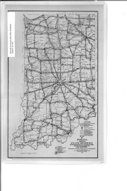
Caption title: Sub-district & road section map. Shows roads by surface and composition type as well as official highway markers, boundaries and headquart...
Call Number:
G4091.P2 1929 .I5
Caption:
Imprint: [Indianapolis] : [Wm. B. Burford, contractor for state printing and binding], [1930] and Imprint: [Indianapolis] : [The Legislative Bureau], [1930]
Physical Description:
Scale: Approximately 1:1,370,000 and Dimensions: 38 x 23 cm, on sheet 43 x 26 cm
Alternate Identifier:
Alternate ID: 397754IP and Title Control Number: a18455618
Caption title: Sub-district & road section map. Shows roads by surface and composition type as well as official highway markers, boundaries and headquart...
Call Number:
G4091.P2 1928 .I5
Caption:
Imprint: [Indianapolis] : [Wm. B. Burford, contractor for state printing and binding], [1929] and Imprint: [Indianapolis] : [The Legislative Bureau], [1929]
Physical Description:
Scale: Approximately 1:1,370,000 and Dimensions: 36 x 23 cm, on sheet 41 x 26 cm
Alternate Identifier:
Title Control Number: a18455614 and Alternate ID: 397754IP
Shows roads by surface and composition type as well as official highway markers, boundaries and headquarters for districts and sub-districts, and constructio...
Call Number:
G4091.P2 1927 .I5
Caption:
Imprint: [Indianapolis] : [Wm. B. Burford, contractor for state printing and binding], [1928] and Imprint: [Indianapolis] : [The Legislative Bureau], [1928]
Physical Description:
Scale: Approximately 1:1,370,000 and Dimensions: 36 x 23 cm, on sheet 41 x 26 cm
Alternate Identifier:
Alternate ID: 397754IP and Title Control Number: a18455609
Shows brick, concrete and bituminous surfaced roads, stone and gravel roads, and earth roads, as well as hard surfaced roads and stone and gravel roads under...
Call Number:
G4091.P2 1923 .I5
Caption:
Imprint: [Indianapolis] : [Wm. B. Burford], [1924]
Physical Description:
Dimensions: 36 x 22 cm and Scale: Approximately 1:1,330,560
Alternate Identifier:
Alternate ID: 397754IP and Title Control Number: a15733507
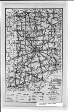
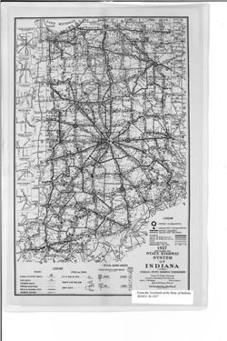
Shows roads by general material type as well as boundaries and headquarters for districts and sub-districts. "H. D. Bodine - Sep. 28 '25." D...
Call Number:
G4091.P2 1924 .I5
Caption:
Imprint: [Indianapolis] : [The Legislative Bureau], [1925] and Imprint: [Indianapolis] : [Wm. B. Burford, contractor for state printing and binding], [1925]
Physical Description:
Scale: Approximately 1:1,370,000 and Dimensions: 35 x 22 cm, on sheet 40 x 25 cm
Alternate Identifier:
Alternate ID: 397754IP and Title Control Number: a18455610
Appears in Report of State Highway Commission. In Year book of the state of Indiana for the year 1917. Indianapolis : Wm. B. Burford, contractor for state pr...
Call Number:
JK5631 .I6 1917
Caption:
Imprint: [Indianapolis] : [Wm. B. Burford, contractor for state printing and binding], [1918]
Physical Description:
Scale: Approximately 1:2,600,000 and Dimensions: on sheet 15 x 25 cm
Alternate Identifier:
Alternate ID: 397754IP and Title Control Number: a18422936
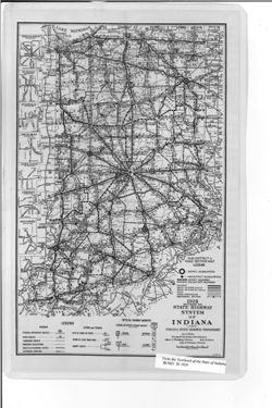
Shows road surface and composition types as well as paving and grading work performed under the 1931 construction program. Additional title information from ...
Call Number:
G4091.P2 1931 .I53
Caption:
Imprint: [Indianapolis] : [Wm. B. Burford, contractor for state printing and binding], [1932] and Imprint: [Indianapolis] : [The Legislative Bureau], [1932]
Physical Description:
Scale: Approximately 1:1,280,000 and Dimensions: 42 x 27 cm, on sheet 44 x 29 cm
Alternate Identifier:
Alternate ID: 397754IP and Title Control Number: a18422882
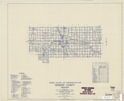
Geographic Subject: Howard County (Ind.) and Topical Subject: Roads
Creator:
Indiana. State Highway Commission (1919-1953)
Publisher:
State Highway Commission of Indiana
Date Created:
1949
Identifier:
VAC3073-M-01000
Genre:
Road maps
Geographic Location:
Coordinates: W0862200 W0855200 N0403400 N0402200
Related URL:
Catalog URL: https://iucat.iu.edu/catalog/5732724
Abstract:
Blueline. "State roads revised to January 1, 1949.: "Data obtained from State-wide Highway Planning Survey." Includes chart "Culture in u...
Call Number:
G4093.H7P2 1949 .I53
Caption:
Imprint: [Indianapolis?] : State Highway Commission of Indiana, 1949.
Geographic Subject: Monroe County (Ind.) and Topical Subject: Roads
Creator:
Indiana. State Highway Commission (1919-1953)
Publisher:
Indiana. State Highway Commission (1919-1953)
Date Created:
1937
Identifier:
VAC3073-M-00994
Genre:
Road maps
Geographic Location:
Coordinates: W0864100 W0861900 N0392100 N0390000
Related URL:
Catalog URL: https://iucat.iu.edu/catalog/5706988
Abstract:
Blueline. "1937." "53." "Corrected to January 1, 1937." Includes location map and chart of "Culture in unincorporated plac...
Call Number:
G4093.M7P2 1937 .I52
Caption:
Imprint: [Indianapolis] : State Highway Commission of Indiana, 1937.
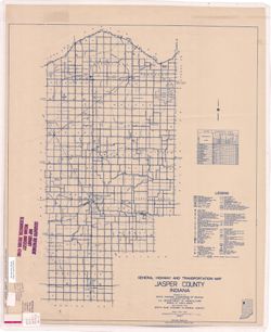
Topical Subject: Roads and Geographic Subject: Jasper County (Ind.)
Creator:
Indiana. State Highway Commission (1919-1953)
Publisher:
Indiana. State Highway Commission (1919-1953)
Date Created:
1937
Identifier:
VAC3073-M-00993
Genre:
Road maps
Geographic Location:
Coordinates: W0871700 W0865600 N0411700 N0404400
Related URL:
Catalog URL: https://iucat.iu.edu/catalog/5362493
Abstract:
Blue line print. "Corrected to January 1, 1937." "Data obtained from State-wide Highway Planning Survey." Includes chart "Culture in...

![State highway system of Indiana [1924]](https://iiif.uits.iu.edu/iiif/2/cc08jj98p%2Ffiles%2F60667ab8-b573-4e3f-8700-1616072ff131/full/250,/0/default.jpg)
![State highway system of Indiana : [1931 construction program]](https://iiif.uits.iu.edu/iiif/2/q524ks71g%2Ffiles%2Fc6019e35-4de2-4274-8558-ff96d913a736/full/250,/0/default.jpg)