
Search Constraints
You searched for:
State/Province
Белорусская ССР (Byelorussian Soviet Socialist Republic)
Remove constraint State/Province: Белорусская ССР (Byelorussian Soviet Socialist Republic)
« Previous |
1 - 20 of 596
|
Next »
Search Results
-
- Description:
- 1886
- Subject:
- Geographic Subject: Damachava, Topical Subject: Soviet Union, and Topical Subject: Maps
- Publisher:
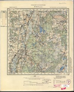
- Генеральный штаб Красной Армии
- Language:
- Russian
- Date Created:
- 1931
- Identifier:
- VAC9619-002741
- Genre:
- Military Maps and Topographic Maps
- Geographic Location:
- Coordinates: 51.667, 23.5, 52, 24
- Related URL:
- Download GeoTIFF: https://drive.google.com/file/d/1-Trah_-vgFFtif-3WIcNxEdhNsP33Yim/view?usp=sharing and Catalog URL: https://iucat.iu.edu/catalog/5020129
- Abstract:
- Modern area represented: Damachava, Brest oblast, Belarus
- Call Number:
- G7000 s100 .S7 sheet M-34-12
- City:
- Домачево (Damachava)
- Copyright Holder:
- No Copyright - United States
- Country:
- СССР (USSR)
- State/Province:
- Брестская область (Brest oblast), Белорусская ССР (Byelorussian Soviet Socialist Republic), and Область государственных интересов Германии (Region of German ...
- Physical Description:
- Scale: 1:100,000
- Persistent URL:
- http://purl.dlib.indiana.edu/iudl/images/VAC9619/VAC9619-002741
- Provenance:
- CIA Map Library, Geographisches Institut der Universität Bonn
-
- Description:
- 1887
- Subject:
- Geographic Subject: Włodawa, Topical Subject: Soviet Union, and Topical Subject: Maps
- Publisher:
- Генеральный штаб Красной Армии
- Language:
- Russian
- Date Created:
- 1940
- Identifier:
- VAC9619-002762
- Genre:
- Topographic Maps and Military Maps
- Geographic Location:
- Coordinates: 51.333, 23.5, 51.667, 24
- Related URL:
- Download GeoTIFF: https://drive.google.com/file/d/1JDSewJzA527Bsgf8IU4mRbgUGxkzEMLY/view?usp=sharing and Catalog URL: https://iucat.iu.edu/catalog/5020129
- Abstract:
- Modern area represented: Włodawa, Lublin province, Poland
- Call Number:
- G7000 s100 .S7 sheet M-34-24
- City:
- Влодава (Włodawa)
- Copyright Holder:
- No Copyright - United States
- Country:
- СССР (USSR)
- State/Province:
- Волынская область (Volyn oblast), Белорусская ССР (Byelorussian Soviet Socialist Republic), Брестская область (Brest oblast), Украинская ССР (Ukrainian Sovie...
- Physical Description:
- Scale: 1:100,000
- Persistent URL:
- http://purl.dlib.indiana.edu/iudl/images/VAC9619/VAC9619-002762
- Provenance:
- DMA Topographic Center, Library of Congress Geography & Map Division, Army Map Service Library, OMAHA
-
- Description:
- 1887
- Subject:
- Topical Subject: Maps, Geographic Subject: Malaryta, and Topical Subject: Soviet Union
- Publisher:
- Генеральный штаб Красной Армии
- Language:
- Russian
- Date Created:
- 1938
- Identifier:
- VAC9619-003044
- Genre:
- Military Maps and Topographic Maps
- Geographic Location:
- Coordinates: 51.667, 24, 52, 24.5
- Related URL:
- Catalog URL: https://iucat.iu.edu/catalog/5020129 and Download GeoTIFF: https://drive.google.com/file/d/1S8NvMKAOIykvpvbNAoK7uWMBQslFwWZB/view?usp=sharing
- Abstract:
- Modern area represented: Malaryta, Brest oblast, Belarus
- Call Number:
- G7000 s100 .S7 sheet M-35-1
- City:
- Малорыта (Malaryta)
- Copyright Holder:
- No Copyright - United States
- Country:
- СССР (USSR)
- State/Province:
- Белорусская ССР (Byelorussian Soviet Socialist Republic), Волынская область (Volyn oblast), Украинская ССР (Ukrainian Soviet Socialist Republic), and Брестск...
- Physical Description:
- Scale: 1:100,000
- Persistent URL:
- http://purl.dlib.indiana.edu/iudl/images/VAC9619/VAC9619-003044
- Provenance:
- DMA Topographic Center, Army Map Service Library, OMAHA, Library of Congress Geography & Map Division
-
- Description:
- 1929
- Subject:
- Topical Subject: Soviet Union, Geographic Subject: Yelsk, and Topical Subject: Maps
- Publisher:
- Управление военных топографов РККА
- Language:
- Russian
- Date Created:
- 1931
- Identifier:
- VAC9619-003048
- Genre:
- Topographic Maps and Military Maps
- Geographic Location:
- Coordinates: 51.667, 29, 52, 29.5
- Related URL:
- Download GeoTIFF: https://drive.google.com/file/d/1ly2jIDqmS_8iOt2QwCBH2oYCvLx95adN/view?usp=sharing and Catalog URL: https://iucat.iu.edu/catalog/5020129
- Abstract:
- Modern area represented: Yelsk, Gomel oblast, Belarus
- Call Number:
- G7000 s100 .S7 sheet M-35-11
- Caption:
- Не подлежит оглашению
- City:
- Ельск (Yelsk)
- Copyright Holder:
- No Copyright - United States
- Country:
- СССР (USSR)
- State/Province:
- Белорусская ССР (Byelorussian Soviet Socialist Republic)
- Physical Description:
- Scale: 1:100,000
- Persistent URL:
- http://purl.dlib.indiana.edu/iudl/images/VAC9619/VAC9619-003048
- Provenance:
- DMA Topographic Center, Army Map Service Library, OMAHA, Library of Congress Geography & Map Division
-
- Description:
- 1891
- Subject:
- Topical Subject: Soviet Union, Geographic Subject: Nova Vyzhva, and Topical Subject: Maps
- Publisher:
- Генеральный штаб РККА
- Language:
- Russian
- Date Created:
- 1938
- Identifier:
- VAC9619-003049
- Genre:
- Military Maps and Topographic Maps
- Geographic Location:
- Coordinates: 51.333, 24, 51.667, 24.5
- Related URL:
- Catalog URL: https://iucat.iu.edu/catalog/5020129 and Download GeoTIFF: https://drive.google.com/file/d/1W2o9oT7WY5SqldSOwDUoKIQfVeQ6GSSo/view?usp=sharing
- Abstract:
- Modern area represented: Nova Vyzhva, Volyn oblast, Ukraine
- Call Number:
- G7000 s100 .S7 sheet M-35-13
- City:
- Нов. Выжва (Nova Vyzhva)
- Copyright Holder:
- No Copyright - United States
- Country:
- СССР (USSR)
- State/Province:
- Украинская ССР (Ukrainian Soviet Socialist Republic), Белорусская ССР (Byelorussian Soviet Socialist Republic), Брестская область (Brest oblast), and Волынск...
- Physical Description:
- Scale: 1:100,000
- Persistent URL:
- http://purl.dlib.indiana.edu/iudl/images/VAC9619/VAC9619-003049
- Provenance:
- DMA Topographic Center, Army Map Service Library, OMAHA, Library of Congress Geography & Map Division
-
- Description:
- 1899
- Subject:
- Topical Subject: Maps, Geographic Subject: Divin, and Topical Subject: Soviet Union
- Publisher:
- Генеральный штаб Красной Армии
- Language:
- Russian
- Date Created:
- 1938
- Identifier:
- VAC9619-003045
- Genre:
- Military Maps and Topographic Maps
- Geographic Location:
- Coordinates: 51.667, 24.5, 52, 25
- Related URL:
- Catalog URL: https://iucat.iu.edu/catalog/5020129 and Download GeoTIFF: https://drive.google.com/file/d/1kwuxEIyhZC6KtNwxUv0XBd3cHBvkR2O3/view?usp=sharing
- Abstract:
- Modern area represented: Divin, Brest oblast, Belarus
- Call Number:
- G7000 s100 .S7 sheet M-35-2
- City:
- Дывин (Divin)
- Copyright Holder:
- No Copyright - United States
- Country:
- СССР (USSR)
- State/Province:
- Украинская ССР (Ukrainian Soviet Socialist Republic), Брестская область (Brest oblast), Волынская область (Volyn oblast), and Белорусская ССР (Byelorussian S...
- Physical Description:
- Scale: 1:100,000
- Persistent URL:
- http://purl.dlib.indiana.edu/iudl/images/VAC9619/VAC9619-003045
- Provenance:
- DMA Topographic Center, Army Map Service Library, OMAHA, Library of Congress Geography & Map Division, Aeronautical Chart & Information Center
-
- Description:
- 1916
- Subject:
- Geographic Subject: Yurove, Topical Subject: Maps, and Topical Subject: Soviet Union
- Publisher:
- Генеральный штаб РККА
- Language:
- Russian
- Date Created:
- 1938
- Identifier:
- VAC9619-003052
- Genre:
- Topographic Maps and Military Maps
- Geographic Location:
- Coordinates: 51.333, 27.5, 51.667, 28
- Related URL:
- Catalog URL: https://iucat.iu.edu/catalog/5020129 and Download GeoTIFF: https://drive.google.com/file/d/1-oy_tglW6Q5zk4yBjiwIDUI0AvmpI7Ce/view?usp=sharing
- Abstract:
- Modern area represented: Yurove, Zhytomyr oblast, Ukraine
- Call Number:
- G7000 s100 .S7 sheet M-35-20
- Caption:
- Не подлежит оглашению
- City:
- Юрово (Yurovo)
- Copyright Holder:
- No Copyright - United States
- Country:
- СССР (USSR)
- State/Province:
- Полесская область (Polesia oblast), Белорусская ССР (Byelorussian Soviet Socialist Republic), Ровенская область (Rivne oblast), Житомирская область (Zhytomyr...
- Physical Description:
- Scale: 1:100,000
- Persistent URL:
- http://purl.dlib.indiana.edu/iudl/images/VAC9619/VAC9619-003052
- Provenance:
- DMA Topographic Center, Army Map Service Library, OMAHA, Library of Congress Geography & Map Division
-
- Description:
- 1931
- Subject:
- Topical Subject: Maps, Topical Subject: Soviet Union, and Geographic Subject: Vystupovychi
- Publisher:
- Генеральный штаб РККА
- Language:
- Russian
- Identifier:
- VAC9619-003053
- Genre:
- Topographic Maps and Military Maps
- Geographic Location:
- Coordinates: 51.333, 20, 51.667, 20.5
- Related URL:
- Catalog URL: https://iucat.iu.edu/catalog/5020129 and Download GeoTIFF: https://drive.google.com/file/d/1lyWnJWxZnef203G9KBIGyYQd7aYiD9x8/view?usp=sharing
- Abstract:
- Modern area represented: Vystupovychi, Zhytomyr oblast, Ukraine
- Call Number:
- G7000 s100 .S7 sheet M-35-23
- Caption:
- Не подлежит оглашению
- City:
- Выступовичи (Vystupovychi)
- Copyright Holder:
- No Copyright - United States
- Country:
- СССР (USSR)
- State/Province:
- Украинская ССР (Ukrainian Soviet Socialist Republic) and Белорусская ССР (Byelorussian Soviet Socialist Republic)
- Physical Description:
- Scale: 1:100,000
- Persistent URL:
- http://purl.dlib.indiana.edu/iudl/images/VAC9619/VAC9619-003053
- Provenance:
- DMA Topographic Center, Army Map Service Library, OMAHA, Library of Congress Geography & Map Division
-
- Description:
- 1931
- Subject:
- Topical Subject: Soviet Union, Topical Subject: Maps, and Geographic Subject: Tovstyy Lis
- Publisher:
- Генеральный штаб РККА
- Language:
- Russian
- Identifier:
- VAC9619-003109
- Genre:
- Topographic Maps and Military Maps
- Geographic Location:
- Coordinates: 51.333, 29.5, 51.667, 30
- Related URL:
- Download GeoTIFF: https://drive.google.com/file/d/1vZVXoMPd7x-2yVu8aMrmdzmHak7t6-UQ/view?usp=sharing and Catalog URL: https://iucat.iu.edu/catalog/5020129
- Abstract:
- Modern area represented: Tovstyy Lis, Ukraine
- Call Number:
- G7000 s100 .S7 sheet M-35-24
- Caption:
- Не подлежит оглашению
- City:
- Толстый Лес (Tolstyy Les)
- Copyright Holder:
- No Copyright - United States
- Country:
- СССР (USSR)
- State/Province:
- Украинская ССР (Ukrainian Soviet Socialist Republic), Белорусская ССР (Byelorussian Soviet Socialist Republic), and Киевская область (Kyiv oblast)
- Physical Description:
- Scale: 1:100,000
- Persistent URL:
- http://purl.dlib.indiana.edu/iudl/images/VAC9619/VAC9619-003109
- Provenance:
- DMA Topographic Center, Army Map Service Library, OMAHA, Library of Congress Geography & Map Division
-
- Description:
- 1931
- Subject:
- Geographic Subject: Denysovychi, Topical Subject: Maps, and Topical Subject: Soviet Union
- Publisher:
- Управление военных топографов
- Language:
- Russian
- Identifier:
- VAC9619-000191
- Genre:
- Topographic Maps and Military Maps
- Geographic Location:
- Coordinates: 51.333, 29.5, 51.5, 29.75
- Related URL:
- Catalog URL: http://iucat.iu.edu/catalog/5020131 and Download GeoTIFF: https://drive.google.com/open?id=1OHO2536LziDQohcfqTCZ2x6pDoc3y3uv
- Abstract:
- abandoned populated place (the residents were resettled as the result of the Chernobyl accident) and Modern area represented: Denysovychi, Ukraine
- Call Number:
- G7000 s50 .S68 and zsheet M-35-24-C
- Caption:
- Не подлежит оглашению
- City:
- Денисовичи (Denisovichi)
- Copyright Holder:
- No Copyright - United States
- Country:
- СССР (USSR)
- State/Province:
- Украинская ССР (Ukrainian Soviet Socialist Republic) and Белорусская ССР (Byelorussian Soviet Socialist Republic)
- Physical Description:
- Scale: 1:50,000
- Persistent URL:
- http://purl.dlib.indiana.edu/iudl/images/VAC9619/VAC9619-000191
- Provenance:
- DMA Topographic Center, Army Map Service Library, OMAHA, Library of Congress Geography & Map Division
-
- Description:
- 1931
- Subject:
- Topical Subject: Soviet Union, Geographic Subject: Tovstyi Lis, and Topical Subject: Maps
- Publisher:
- Управление военных топографов
- Language:
- Russian
- Identifier:
- VAC9619-000192
- Genre:
- Topographic Maps and Military Maps
- Geographic Location:
- Coordinates: 51.333, 29.75, 51.5, 30
- Related URL:
- Catalog URL: http://iucat.iu.edu/catalog/5020131 and Download GeoTIFF: https://drive.google.com/open?id=1VNYar89ax3ofZHmK7pMkpnfLwmpdP3ro
- Abstract:
- Modern area represented: Tovstyi Lis, Ukraine and an abandoned populated place (the residents were resettled as the result of the Chernobyl accident)
- Call Number:
- G7000 s50 .S68 sheet M-35-24-D
- Caption:
- Не подлежит оглашению
- City:
- Толстый Лес (Tolstyy Les)
- Copyright Holder:
- No Copyright - United States
- Country:
- СССР (USSR)
- State/Province:
- Белорусская ССР (Byelorussian Soviet Socialist Republic) and Украинская ССР (Ukrainian Soviet Socialist Republic)
- Physical Description:
- Scale: 1:50,000
- Persistent URL:
- http://purl.dlib.indiana.edu/iudl/images/VAC9619/VAC9619-000192
- Provenance:
- DMA Topographic Center, Army Map Service Library, OMAHA, Library of Congress Geography & Map Division
-
- Description:
- 1910
- Subject:
- Topical Subject: Soviet Union, Topical Subject: Maps, and Geographic Subject: Sernyky
- Publisher:
- Генеральный штаб Красной Армии
- Language:
- Russian
- Date Created:
- 1938
- Identifier:
- VAC9619-003046
- Genre:
- Military Maps and Topographic Maps
- Geographic Location:
- Coordinates: 51.667, 26, 52, 26.5
- Related URL:
- Catalog URL: https://iucat.iu.edu/catalog/5020129 and Download GeoTIFF: https://drive.google.com/file/d/1H9UQ5jmL2sxn7oKF5G4mXmAdfHP5hUmz/view?usp=sharing
- Abstract:
- Modern area represented: Sernyky, Rivne oblast, Ukraine
- Call Number:
- G7000 s100 .S7 sheet M-35-5
- City:
- Серники (Sernyky)
- Copyright Holder:
- No Copyright - United States
- Country:
- СССР (USSR)
- State/Province:
- Пинская область (Pinsk oblast), Белорусская ССР (Byelorussian Soviet Socialist Republic), Ровенская область (Rivne oblast), and Украинская ССР (Ukrainian Sov...
- Physical Description:
- Scale: 1:100,000
- Persistent URL:
- http://purl.dlib.indiana.edu/iudl/images/VAC9619/VAC9619-003046
- Provenance:
- DMA Topographic Center, Army Map Service Library, OMAHA, Library of Congress Geography & Map Division
-
- Description:
- 1910
- Subject:
- Geographic Subject: Stolin, Topical Subject: Maps, and Topical Subject: Soviet Union
- Publisher:
- Генеральный штаб Красной Армии
- Language:
- Russian
- Date Created:
- 1938
- Identifier:
- VAC9619-003047
- Genre:
- Topographic Maps and Military Maps
- Geographic Location:
- Coordinates: 51.667, 26.5, 52, 27
- Related URL:
- Catalog URL: https://iucat.iu.edu/catalog/5020129 and Download GeoTIFF: https://drive.google.com/file/d/1nMsS6EJ0nP-ZvW5_Q23N5TAeluKjPv9v/view?usp=sharing
- Abstract:
- Modern area represented: Stolin, Brest oblast, Belarus
- Call Number:
- G7000 s100 .S7 sheet M-35-6
- City:
- Столин (Stolin)
- Copyright Holder:
- No Copyright - United States
- Country:
- СССР (USSR)
- State/Province:
- Украинская ССР (Ukrainian Soviet Socialist Republic), Белорусская ССР (Byelorussian Soviet Socialist Republic), Пинская область (Pinsk oblast), and Ровенская...
- Physical Description:
- Scale: 1:100,000
- Persistent URL:
- http://purl.dlib.indiana.edu/iudl/images/VAC9619/VAC9619-003047
- Provenance:
- DMA Topographic Center, Army Map Service Library, OMAHA, Library of Congress Geography & Map Division
-
- Description:
- 1929
- Subject:
- Geographic Subject: Brahin, Topical Subject: Soviet Union, and Topical Subject: Maps
- Publisher:
- Генеральный штаб Красной Армии
- Language:
- Russian
- Date Created:
- 1931
- Identifier:
- VAC9619-003253
- Genre:
- Topographic Maps and Military Maps
- Geographic Location:
- Coordinates: 51.667, 30, 52, 30.5
- Related URL:
- Catalog URL: https://iucat.iu.edu/catalog/5020129 and Download GeoTIFF: https://drive.google.com/file/d/1DmGOgTSDSLgB3RRHb_WcHvyVU5nekPPW/view?usp=sharing
- Abstract:
- Modern area represented: Brahin, Gomel region, Belarus
- Call Number:
- G7000 s100 .S7 sheet M-36-1
- Caption:
- Для служебного пользования
- City:
- Брагин (Brahin)
- Copyright Holder:
- No Copyright - United States
- Country:
- СССР (USSR)
- State/Province:
- Белорусская ССР (Byelorussian Soviet Socialist Republic)
- Physical Description:
- Scale: 1:100,000
- Persistent URL:
- http://purl.dlib.indiana.edu/iudl/images/VAC9619/VAC9619-003253
- Provenance:
- DMA Topographic Center, Army Map Service Library, OMAHA
-
- Description:
- 1929
- Subject:
- Geographic Subject: Posudovo, Topical Subject: Soviet Union, and Topical Subject: Maps
- Publisher:
- Генеральный штаб РККА
- Language:
- Russian
- Date Created:
- 1931
- Identifier:
- VAC9619-003263
- Genre:
- Topographic Maps and Military Maps
- Geographic Location:
- Coordinates: 51.333, 30, 51.667, 30.5
- Related URL:
- Download GeoTIFF: https://drive.google.com/file/d/17GpaG4-rhuixjAbMP4KJMfqsHUTaVlV3/view?usp=sharing and Catalog URL: https://iucat.iu.edu/catalog/5020129
- Abstract:
- Modern area represented: Posudovo, Gomel oblast, Belarus
- Call Number:
- G7000 s100 .S7 sheet M-36-13
- Caption:
- Не подлежит оглашению
- City:
- Посудово (Posudovo)
- Copyright Holder:
- No Copyright - United States
- Country:
- СССР (USSR)
- State/Province:
- Полесская область (Polesia oblast), Киевская область (Kyiv oblast), Украинская ССР (Ukrainian Soviet Socialist Republic), and Белорусская ССР (Byelorussian S...
- Physical Description:
- Scale: 1:100,000
- Persistent URL:
- http://purl.dlib.indiana.edu/iudl/images/VAC9619/VAC9619-003263
- Provenance:
- DMA Topographic Center, Army Map Service Library, OMAHA
-
- Description:
- 1929
- Subject:
- Topical Subject: Soviet Union, Topical Subject: Maps, and Geographic Subject: Kolpyta
- Publisher:
- Генеральный штаб Красной Армии
- Language:
- Russian
- Date Created:
- 1941
- Identifier:
- VAC9619-003264
- Genre:
- Topographic Maps and Military Maps
- Geographic Location:
- Coordinates: 51.333, 30.5, 51.667, 31
- Related URL:
- Download GeoTIFF: https://drive.google.com/file/d/1cL08hadD7DN7oxpKr2WVT0UmORBrZC4q/view?usp=sharing and Catalog URL: https://iucat.iu.edu/catalog/5020129
- Abstract:
- Modern area represented: Kolpyta, Chernihiv oblast, Ukraine
- Call Number:
- G7000 s100 .S7 sheet M-36-14
- Caption:
- Для служебного пользования
- City:
- Колпыта (Kolpyta)
- Copyright Holder:
- No Copyright - United States
- Country:
- СССР (USSR)
- State/Province:
- Белорусская ССР (Byelorussian Soviet Socialist Republic) and Украинская ССР (Ukrainian Soviet Socialist Republic)
- Physical Description:
- Scale: 1:100,000
- Persistent URL:
- http://purl.dlib.indiana.edu/iudl/images/VAC9619/VAC9619-003264
- Provenance:
- DMA Topographic Center, Army Map Service Library, OMAHA, Auswärtiges Amt. Geographischer Dienst
-
- Description:
- 1929
- Subject:
- Topical Subject: Maps, Geographic Subject: Loyew, and Topical Subject: Soviet Union
- Publisher:
- Генеральный штаб Красной Армии
- Language:
- Russian
- Date Created:
- 1941
- Identifier:
- VAC9619-003254
- Genre:
- Topographic Maps and Military Maps
- Geographic Location:
- Coordinates: 51.667, 30.5, 52, 31
- Related URL:
- Catalog URL: https://iucat.iu.edu/catalog/5020129 and Download GeoTIFF: https://drive.google.com/file/d/1pts7bgzSOMFuWGK1hGOGVJSjwKFOPf_0/view?usp=sharing
- Abstract:
- Modern area represented: Loyew, Gomel oblast, Belarus
- Call Number:
- G7000 s100 .S7 sheet M-36-2
- Caption:
- Для служебного пользования
- City:
- Лоев (Loyew)
- Copyright Holder:
- No Copyright - United States
- Country:
- СССР (USSR)
- State/Province:
- Полесская область (Polesia oblast), Гомельская область (Homyel oblast), Украинская ССР (Ukrainian Soviet Socialist Republic), Белорусская ССР (Byelorussian S...
- Physical Description:
- Scale: 1:100,000
- Persistent URL:
- http://purl.dlib.indiana.edu/iudl/images/VAC9619/VAC9619-003254
- Provenance:
- DMA Topographic Center, Army Map Service Library, OMAHA
-
- Description:
- 1929
- Subject:
- Topical Subject: Maps, Topical Subject: Soviet Union, and Geographic Subject: Chornobyl
- Publisher:
- Генеральный штаб РККА
- Language:
- Russian
- Date Created:
- 1932
- Identifier:
- VAC9619-003270
- Genre:
- Military Maps and Topographic Maps
- Geographic Location:
- Coordinates: 51, 30, 51.333, 30.5
- Related URL:
- Catalog URL: https://iucat.iu.edu/catalog/5020129 and Download GeoTIFF: https://drive.google.com/file/d/1yIQsvVJLXuA-9oO1lvbl2PPyyofDIkua/view?usp=sharing
- Abstract:
- Modern area represented: Chornobyl, Kiev oblast, Ukraine
- Call Number:
- G7000 s100 .S7 sheet M-36-25
- Caption:
- Не подлежит оглашению
- City:
- Чернобыль (Chornobyl)
- Copyright Holder:
- No Copyright - United States
- Country:
- СССР (USSR)
- State/Province:
- Украинская ССР (Ukrainian Soviet Socialist Republic), Черниговская область (Chernihiv oblast), Полесская область (Polesia oblast), Белорусская ССР (Byeloruss...
- Physical Description:
- Scale: 1:100,000
- Persistent URL:
- http://purl.dlib.indiana.edu/iudl/images/VAC9619/VAC9619-003270
- Provenance:
- DMA Topographic Center, Army Map Service Library, OMAHA, Library of Congress Geography & Map Division
-
- Description:
- 1924
- Subject:
- Topical Subject: Maps, Topical Subject: Soviet Union, and Geographic Subject: Sorokoshichi
- Publisher:
- Генеральный штаб Красной Армии
- Language:
- Russian
- Date Created:
- 1941
- Identifier:
- VAC9619-003271
- Genre:
- Topographic Maps and Military Maps
- Geographic Location:
- Coordinates: 51, 30.5, 51.333, 31
- Related URL:
- Download GeoTIFF: https://drive.google.com/file/d/1KxaQ7Xoh_2tWdxEvMRNheFDM8vAmtddO/view?usp=sharing and Catalog URL: https://iucat.iu.edu/catalog/5020129
- Abstract:
- Modern area represented: Sorokoshichi, Chernihiv oblast, Ukraine
- Call Number:
- G7000 s100 .S7 sheet M-36-26
- Caption:
- Для служебного пользования
- City:
- Сорокошичи (Sorokoshichi)
- Copyright Holder:
- No Copyright - United States
- Country:
- СССР (USSR)
- State/Province:
- Полесская область (Polesia oblast), Белорусская ССР (Byelorussian Soviet Socialist Republic), Украинская ССР (Ukrainian Soviet Socialist Republic), and Черни...
- Physical Description:
- Scale: 1:100,000
- Persistent URL:
- http://purl.dlib.indiana.edu/iudl/images/VAC9619/VAC9619-003271
- Provenance:
- DMA Topographic Center, Army Map Service Library
-
- Description:
- 1936
- Subject:
- Geographic Subject: Цялуша (Tsyalusha), Topical Subject: Maps, and Topical Subject: Soviet Union
- Publisher:
- Управление военных топографов РККА
- Language:
- Russian
- Identifier:
- VAC9619-000688
- Genre:
- Military Maps and Topographic Maps
- Geographic Location:
- Coordinates: 53, 29.25, 53.167, 29.5
- Related URL:
- Catalog URL: http://iucat.iu.edu/catalog/5020131 and Download GeoTIFF: https://drive.google.com/open?id=1nvaI2IHl54oUqJlue5iSNA0IS1qXVbeG
- Abstract:
- Modern area represented: Цялуша (Tsyalusha), Mogilev oblast, Belarus
- Call Number:
- G7000 s50 .S68 sheet N-35-107-D
- Caption:
- Не подлежит оглашению and Captured map
- City:
- Телуша (Telusha)
- Copyright Holder:
- No Copyright - United States
- Country:
- СССР (USSR)
- State/Province:
- Белорусская ССР (Byelorussian Soviet Socialist Republic)
- Physical Description:
- Scale: 1:50,000
- Persistent URL:
- http://purl.dlib.indiana.edu/iudl/images/VAC9619/VAC9619-000688
- Provenance:
- Army Map Service Library, OMAHA, Library of Congress Geography & Map Division
