
Search Constraints
You searched for:
Date Created
1909
Remove constraint Date Created: 1909
Collections
Indiana Historic Maps
Remove constraint Collections: Indiana Historic Maps
« Previous |
1 - 10 of 17
|
Next »
Search Results
-
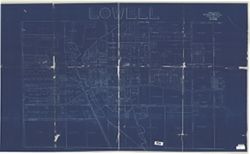
- Subject:
- Geographic Subject: Lowell (Lake County, Ind.), Topical Subject: Real property, and Topical Subject: Landowners
- Creator:
- F.L. Knight & Sons
- Publisher:
- F.L. Knight & Sons
- Date Created:
- 1909
- Identifier:
- VAC3073-M-00384
- Genre:
- Cadastral maps
- Geographic Location:
- Coordinates: W0872641 W0872302 N0411857 N0411638
- Related URL:
- Catalog URL: https://iucat.iu.edu/catalog/4681792
- Abstract:
- Blueprint. Cadastral map showing landowners.
- Call Number:
- G4094 .L8G46 1909 .F575
- Caption:
- Imprint: Crown Point, Ind. : F. L. Knight & Sons, 1909.
- Physical Description:
- Scale: Approximately 1:1,200. 1 inch = 100 feet and Dimensions: 118 x 203 cm
- Alternate Identifier:
- Title Control Number: CAT7779BB
- Persistent URL:
- https://purl.dlib.indiana.edu/iudl/images/VAC3073/VAC3073-M-00384
-
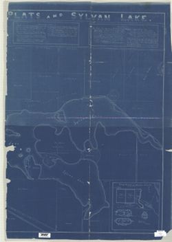
- Subject:
- Geographic Subject: Noble County (Ind.), Geographic Subject: Rome City (Ind.), Geographic Subject: Sylvan Lake (Ind.), Topical Subject: Real property, and To...
- Creator:
- Owen, M. F. (Millard Fillmore), 1851-1932
- Publisher:
- [M.F. Owen]
- Date Created:
- 1909
- Identifier:
- VAC3073-M-00846
- Genre:
- Cadastral maps
- Geographic Location:
- Coordinates: W0852308 W0851939 N0413011 N0412827
- Related URL:
- Catalog URL: https://iucat.iu.edu/catalog/4676408
- Abstract:
- Blueprint. Originally copied on 4 sheets. Includes text and insets: "Map of bluffs, bridges, wagon road and banks upon which Northport Feeder Dam was...
- Call Number:
- G4094 .R85G46 1909 .O94
- Caption:
- Imprint: [Rome City (Ind.)?] : [M.F. Owen], 1909.
- Physical Description:
- Dimensions: 125 x 177 cm, on sheets 133 x 93 and 129 x 93 cm and Scale: 1:2,700
- Alternate Identifier:
- Title Control Number: CAQ5632BB
- Persistent URL:
- https://purl.dlib.indiana.edu/iudl/images/VAC3073/VAC3073-M-00846
-
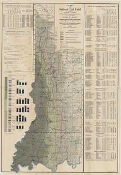
- Subject:
- Topical Subject: Coal mines and mining, Topical Subject: Coal reserves, Geographic Subject: Indiana, Topical Subject: Geology, Stratigraphic, and Topical Sub...
- Creator:
- Lines, E. F. (Edwin Fuller),1875-
- Publisher:
- Indiana. Department of Geology and Natural Resources
- Date Created:
- 1909
- Identifier:
- VAC3073-M-01456
- Genre:
- Geological maps, Mine maps, and Geological cross-sections
- Geographic Location:
- Coordinates: W0880500 W0844700 N0414500 N0374600
- Related URL:
- Catalog URL: https://iucat.iu.edu/catalog/15736302
- Abstract:
- Includes twenty-four columnar sections showing coal measurements and three statistical tables: Table of commercial coal mines -- Summary of coal by counties ...
- Call Number:
- G4091.H5 1909 .L56
- Caption:
- Imprint: Indianapolis : Department of Geology and Natural Resources of Indiana, 1909
- Physical Description:
- Dimensions: 125 x 60 cm and Scale: 1:253,440. Vertical scales differ
- Alternate Identifier:
- Title Control Number: a15736302
- Persistent URL:
- https://purl.dlib.indiana.edu/iudl/images/VAC3073/VAC3073-M-01456
- Provenance:
- 33rd Annual Report (1908) / Indiana. Department of Geology and Natural Resources.
-
![Indiana (Lake County) Toleston quadrangle [sic] [1909 reprint]](https://iiif.uits.iu.edu/iiif/2/kw52kc32n%2Ffiles%2F6730048e-8506-41de-a049-ea31d562429b/full/250,/0/default.jpg)
- Subject:
- Geographic Subject: Lake County (Ind.)
- Creator:
- McKinney, R. C. (Robert C.), Geological Survey (U.S.), Renshawe, John H., and U.S. Lake Survey
- Publisher:
- Geological Survey (U.S.)
- Date Created:
- 1909
- Identifier:
- VAC3073-M-01397
- Genre:
- Quadrangle maps, Topographic maps, and 15 minute topographic maps
- Geographic Location:
- Coordinates: W0873000 W0871500 N0414500 N0413000
- Related URL:
- Catalog URL: https://iucat.iu.edu/catalog/a18406229
- Abstract:
- United States, Department of the Interior, Geological Survey , Jno. H. Renshawe, geographer in charge , control by U.S. Lake Survey , topography by R. C. McK...
- Call Number:
- G4090 s62 .G4 Toleston 1900 rep1909
- Caption:
- Imprint: Washington, D. C. : United States, Department of the Interior, Geological Survey, 1909
- Physical Description:
- Dimensions: 45 x 42 cm or smaller and Scale: 1:62,500
- Alternate Identifier:
- Title Control Number: a18406229
- Persistent URL:
- https://purl.dlib.indiana.edu/iudl/images/VAC3073/VAC3073-M-01397
- Provenance:
- Part of Geological Survey (U.S.). Indiana 1:62,500.
-
![Indiana (Lake County) Toleston quadrangle [sic] [1909 reprint]](https://iiif.uits.iu.edu/iiif/2/9306v273k%2Ffiles%2Fb7dfe6ef-8abd-4000-8209-b517b9c9fc42/full/250,/0/default.jpg)
- Subject:
- Geographic Subject: Lake County (Ind.)
- Creator:
- U.S. Lake Survey, Geological Survey (U.S.), Renshawe, John H., and McKinney, R. C. (Robert C.)
- Publisher:
- Geological Survey (U.S.)
- Date Created:
- 1909
- Identifier:
- VAC3073-M-01306
- Genre:
- Quadrangle maps, Topographic maps, and 15 minute topographic maps
- Geographic Location:
- Coordinates: W0873000 W0871500 N0414500 N0413000
- Related URL:
- Catalog URL: https://iucat.iu.edu/catalog/18406229
- Abstract:
- United States, Department of the Interior, Geological Survey , Jno. H. Renshawe, geographer in charge , control by U.S. Lake Survey , topography by R. C. McK...
- Call Number:
- G4090 s62 .G4 Toleston 1900 R1909
- Caption:
- Imprint: Washington, D. C. : United States, Department of the Interior, Geological Survey, 1909
- Physical Description:
- Scale: 1:62,500 and Dimensions: 45 x 42 cm or smaller
- Alternate Identifier:
- Title Control Number: a18406229
- Persistent URL:
- https://purl.dlib.indiana.edu/iudl/images/VAC3073/VAC3073-M-01306
- Provenance:
- Part of Geological Survey (U.S.). Indiana 1:62,500.
-
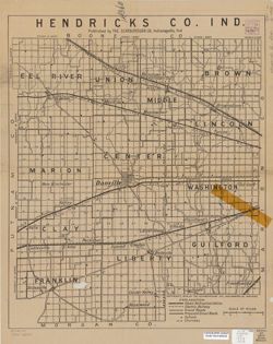
- Subject:
- Geographic Subject: Hendricks County (Ind.)
- Creator:
- Scarborough Company
- Publisher:
- Scarborough Company
- Date Created:
- 1909
- Identifier:
- VAC3073-M-00925
- Genre:
- Maps
- Geographic Location:
- Coordinates: W0864200 W0862000 N0395600 N0393600
- Related URL:
- Catalog URL: https://iucat.iu.edu/catalog/6082128
- Call Number:
- G4093.H5 1909 .S23
- Caption:
- Imprint: Indianapolis, Ind.: Scarborough Co., [1909]
- Physical Description:
- Dimensions: 56 x 46 cm and Scale: 1:65,000
- Alternate Identifier:
- Title Control Number: a6082128
- Persistent URL:
- https://purl.dlib.indiana.edu/iudl/images/VAC3073/VAC3073-M-00925
-
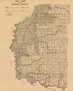
- Subject:
- Geographic Subject: Daviess County (Ind.) and Topical Subject: Soils
- Creator:
- Indiana. Department of Geology and Natural Resources
- Publisher:
- [Indiana Department of Geology and Natural Resources]
- Date Created:
- 1909
- Identifier:
- VAC3073-M-00883
- Genre:
- Thematic maps
- Geographic Location:
- Coordinates: W0871645 W0865414 N0385415 N0382925
- Related URL:
- Catalog URL: https://iucat.iu.edu/catalog/16124707
- Abstract:
- Shows school houses, churches, roads, and railroads. Detached from: A soil survey of four counties of southern Indiana / Chas. W. Shannon and L.C. Snider....
- Call Number:
- G4093.D2J3 1908 .I53
- Caption:
- Imprint: [Indianapolis] : [Indiana Department of Geology and Natural Resources], [1909]
- Physical Description:
- Dimensions: 41 x 33 cm and Scale: Approximately 1:126,720
- Alternate Identifier:
- Alternate ID: 390726IP and Title Control Number: a16124707
- Persistent URL:
- https://purl.dlib.indiana.edu/iudl/images/VAC3073/VAC3073-M-00883
- Provenance:
- 33rd Annual Report (1908) / Indiana. Department of Geology and Natural Resources.
-
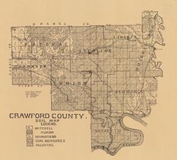
- Subject:
- Topical Subject: IGS Annual Reports, Topical Subject: Soils, and Geographic Subject: Crawford County (Ind.)
- Creator:
- Shannon, C. W. (Charles William), 1879-1934
- Publisher:
- Indiana. Department of Geology and Natural Resources
- Date Created:
- 1909
- Identifier:
- VAC3073-M-00856
- Genre:
- Thematic maps
- Geographic Location:
- Coordinates: W0864052 W0861444 N0382520 N0380617
- Related URL:
- Catalog URL: https://iucat.iu.edu/catalog/16091037
- Abstract:
- Shows school houses, caves, public roads, and railroads. Detached from: A soil survey of four counties of southern Indiana / Chas. W. Shannon and L.C. Sni...
- Call Number:
- G4093.C7J3 1908 .I53
- Caption:
- Imprint: [Indianapolis] : [Wm. B. Burford], [1909] and Imprint: [Indianapolis] : [Indiana Department of Geology and Natural Resources], [1909]
- Physical Description:
- Scale: Approximately 1:130,000 and Dimensions: on sheet 32 x 36 cm
- Alternate Identifier:
- Title Control Number: a16091037 and Alternate ID: 390726IP
- Persistent URL:
- https://purl.dlib.indiana.edu/iudl/images/VAC3073/VAC3073-M-00856
- Provenance:
- 33rd Annual Report (1908) / Indiana. Department of Geology and Natural Resources.
-
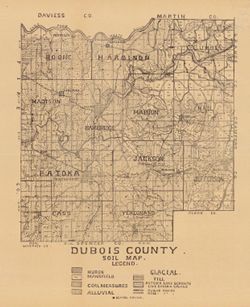
- Subject:
- Topical Subject: Soils and Geographic Subject: Dubois County (Ind.)
- Creator:
- Indiana. Department of Geology and Natural Resources
- Publisher:
- Indiana. Department of Geology and Natural Resources
- Date Created:
- 1909
- Identifier:
- VAC3073-M-00808
- Genre:
- Thematic maps
- Geographic Location:
- Coordinates: W0870420 W0864048 N0383133 N0381222
- Related URL:
- Catalog URL: https://iucat.iu.edu/catalog/16091036
- Abstract:
- Shows school houses, public roads, and railroads. Detached from: A soil survey of four counties of southern Indiana / Chas. W. Shannon and L.C. Snider. In...
- Call Number:
- G4093.D8J3 1908 .I53
- Caption:
- Imprint: [Indianapolis] : [Indiana Department of Geology and Natural Resources], [1909]
- Physical Description:
- Scale: Approximately 1:126,720 and Dimensions: 39 x 33 cm
- Alternate Identifier:
- Title Control Number: a16091036 and Alternate ID: 390726IP
- Persistent URL:
- https://purl.dlib.indiana.edu/iudl/images/VAC3073/VAC3073-M-00808
- Provenance:
- 33rd Annual Report (1908) / Indiana. Department of Geology and Natural Resources.
-
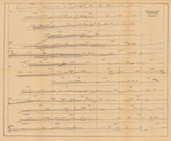
- Subject:
- Topical Subject: Coal, Topical Subject: Geology, Stratigraphic, Topical Subject: IGS Annual Reports, and Geographic Subject: Indiana
- Creator:
- Ashley, Geo. H. (George Hall), 1866-1951
- Publisher:
- Indiana. Department of Geology and Natural Resources
- Date Created:
- 1909
- Identifier:
- VAC3073-M-00650
- Genre:
- Geological cross-sections
- Geographic Location:
- Coordinates: W0880500 W0844700 N0414500 N0374600
- Related URL:
- Catalog URL: https://iucat.iu.edu/catalog/18307698
- Abstract:
- 15 sections on one sheet. Detached from: The coal deposits of Indiana : a supplemental report to the one issued in 1898 / George H. Ashley. In Indiana Dep...
- Call Number:
- QE109 .A2 1908
- Caption:
- Imprint: [Indianapolis] : [Indiana Department of Geology and Natural Resources], [1909]
- Physical Description:
- Dimensions: 44 x 53 cm and Scale: Approximately 1:126,720. 2 miles = 1 inch. Vertical scale approximately 1:12,000. 1,000 feet = 1 inch
- Alternate Identifier:
- Title Control Number: a18307698 and Alternate ID: 390726IP
- Persistent URL:
- https://purl.dlib.indiana.edu/iudl/images/VAC3073/VAC3073-M-00650
- Provenance:
- 33rd Annual Report (1908) / Indiana. Department of Geology and Natural Resources.
