
Search Constraints
You searched for:
Publisher
Indiana. Department of Geology and Natural Resources
Remove constraint Publisher: Indiana. Department of Geology and Natural Resources
Subject
Geographic Subject: Owen County (Ind.)
Remove constraint Subject: Geographic Subject: Owen County (Ind.)
1 - 8 of 8
Search Results
-
- Subject:
- Geographic Subject: Monroe County (Ind.), Geographic Subject: Greene County (Ind.), Geographic Subject: Indiana, Geographic Subject: Owen County (Ind.), and ...
- Publisher:
- Indiana. Department of Geology and Natural Resources
- Date Created:
- 1915
- Identifier:
- VAC3073-M-01188
- Genre:
- Quadrangle maps, Topographic maps, and Geological maps
- Geographic Location:
- Coordinates: W0864500 W0863000 N0391500 N0390000
- Related URL:
- Catalog URL: https://iucat.iu.edu/catalog/16190483
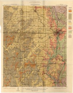
- Abstract:
- Relief shown by contours and spot heights. Contour interval 20 feet. Shows limestone locations in a portion of Monroe County and small portions of Owen and G...
- Call Number:
- G4093.M7C5 1914 .I6
- Caption:
- Imprint: [Indianapolis] : Indiana Dept. of Geology [and Natural Resources], [1915] and Imprint: [Indianapolis] : [Wm. B. Burford], [1915]
- Physical Description:
- Scale: 1:62,500 and Dimensions: 45 x 35 cm
- Alternate Identifier:
- Title Control Number: a16190483 and Alternate ID: 390726IP
- Persistent URL:
- https://purl.dlib.indiana.edu/iudl/images/VAC3073/VAC3073-M-01188
- Provenance:
- 39th Annual Report (1914) / Indiana. Department of Geology and Natural Resources.
-
- Subject:
- Topical Subject: IGS Annual Reports, Geographic Subject: Bloomington (Ind.), Topical Subject: Limestone, Geographic Subject: Owen County (Ind.), Topical Subj...
- Publisher:
- Indiana. Department of Geology and Natural Resources
- Date Created:
- 1897
- Identifier:
- VAC3073-M-01139
- Genre:
- Geological maps
- Geographic Location:
- Coordinates: W0864646 W0862752 N0392732 N0385957
- Related URL:
- Catalog URL: https://iucat.iu.edu/catalog/18416402
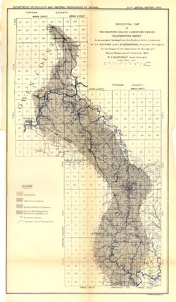
- Abstract:
- To accompany the report on the Bedford Oolitic Limestone by T.C. Hopkins and C.E. Siebenthal. Shows abandoned quarries. Detached from: The Bedford oö...
- Call Number:
- G4094.B5C5 1896 .G4
- Caption:
- Imprint: [Indianapolis] : [Department of Geology and Natural Resources of Indiana], [1897] and Imprint: Indianapolis : Wm. Burford, [1897]
- Physical Description:
- Dimensions: 57 x 28 cm and Scale: Approximately 1:126,720. 2 miles = 1 inch
- Alternate Identifier:
- Alternate ID: 390726IP and Title Control Number: a18416402
- Persistent URL:
- https://purl.dlib.indiana.edu/iudl/images/VAC3073/VAC3073-M-01139
- Provenance:
- 21st Annual Report (1896) / Indiana. Department of Geology and Natural Resources.
-
- Subject:
- Topical Subject: Soils and Geographic Subject: Owen County (Ind.)
- Creator:
- Indiana. Department of Geology and Natural Resources
- Publisher:
- Indiana. Department of Geology and Natural Resources
- Date Created:
- 1912
- Identifier:
- VAC3073-M-01070
- Genre:
- Thematic maps
- Geographic Location:
- Coordinates: W0870317 W0863750 N0392824 N0390956
- Related URL:
- Catalog URL: https://iucat.iu.edu/catalog/16096159
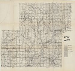
- Abstract:
- Shows soil types. Also shows roads and railroads. Detached from: Soil survey of Owen County / J.B. Edmondson. In Thirty-sixth annual report of Department ...
- Call Number:
- G4093.O8J3 1911 .I53
- Caption:
- Imprint: [Indianapolis] : [Wm. B. Burford], [1912] and Imprint: [Indianapolis] : [Department of Geology and Natural Resources, Indiana], [1912]
- Physical Description:
- Scale: Approximately 1:63,360 and Dimensions: 59 x 65 cm
- Alternate Identifier:
- Title Control Number: a16096159 and Alternate ID: 390726IP
- Persistent URL:
- https://purl.dlib.indiana.edu/iudl/images/VAC3073/VAC3073-M-01070
- Provenance:
- 36th Annual Report (1911) / Indiana. Department of Geology and Natural Resources.
-

- Subject:
- Geographic Subject: Clay County (Ind.), Topical Subject: Coal, Geographic Subject: Putnam County (Ind.), Topical Subject: IGS Annual Reports, Geographic Subj...
- Creator:
- Ashley, Geo. H. (George Hall), 1866-1951, Siebenthal, C. E. (Claude Ellsworth), 1869-1930, and Scovell, J. T. (Josiah Thomas), 1841-
- Publisher:
- Indiana. Department of Geology and Natural Resources
- Date Created:
- 1899
- Identifier:
- VAC3073-M-00899
- Genre:
- Geological maps and Geological cross-sections
- Geographic Location:
- Coordinates: W0873635 W0864028 N0393634 N0390856
- Related URL:
- Catalog URL: https://iucat.iu.edu/catalog/18259650
- Abstract:
- Relief shown by spot heights. Includes map showing coal locations and features, railroads, and quarries as well as vertical cross sections for Dana to Portla...
- Call Number:
- G4093.V5H9 1898 .A84
- Caption:
- Imprint: Indianapolis, Ind. : Wm. B. Burford, [1899]
- Physical Description:
- Scale: Approximately 1:126,720. 2 miles = 1 inch and Dimensions: 48 x 77 cm
- Alternate Identifier:
- Alternate ID: 390726IP and Title Control Number: a18259650
- Persistent URL:
- https://purl.dlib.indiana.edu/iudl/images/VAC3073/VAC3073-M-00899
- Provenance:
- 23rd Annual Report (1898) / Indiana. Department of Geology and Natural Resources.
-
- Subject:
- Geographic Subject: Owen County (Ind.), Geographic Subject: Eel River Valley (Ind. : Valley), Topical Subject: IGS Annual Reports, and Topical Subject: Valleys
- Publisher:
- Indiana. Department of Geology and Natural Resources
- Date Created:
- 1911
- Identifier:
- VAC3073-M-00830
- Genre:
- Topographic maps
- Geographic Location:
- Coordinates: W0865003 W0864726 N0392725 N0392513
- Related URL:
- Catalog URL: https://iucat.iu.edu/catalog/18418393
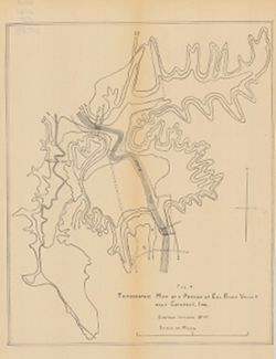
- Abstract:
- Relief shown by contours. Contour interval 20 feet. Shows upper falls dam and proposed lower falls dams now located within the Cataract Falls State Recreatio...
- Call Number:
- G4092.O8C2 1910 .T6
- Caption:
- Imprint: [Indianapolis] : [Wm. B. Burford], [1911] and Imprint: [Indianapolis] : [Indiana Department of Geology and Natural Resources], [1911]
- Physical Description:
- Scale: Approximately 1:7,650 and Dimensions: 31 x 25 cm
- Alternate Identifier:
- Title Control Number: a18418393 and Alternate ID: 390726IP
- Persistent URL:
- https://purl.dlib.indiana.edu/iudl/images/VAC3073/VAC3073-M-00830
- Provenance:
- 35th Annual Report (1910) / Indiana. Department of Geology and Natural Resources.
-
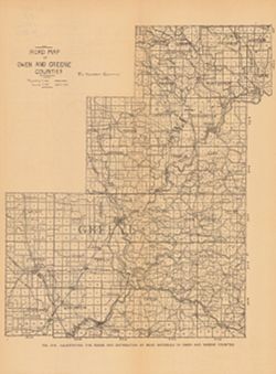
- Subject:
- Geographic Subject: Owen County (Ind.), Topical Subject: Macadam roads, Geographic Subject: Greene County (Ind.), Topical Subject: IGS Annual Reports, Topica...
- Publisher:
- Indiana. Department of Geology and Natural Resources
- Date Created:
- 1906
- Identifier:
- VAC3073-M-00739
- Genre:
- Geological maps and Thematic maps
- Geographic Location:
- Coordinates: W0871431 W0863820 N0392826 N0385418
- Related URL:
- Catalog URL: https://iucat.iu.edu/catalog/18299126
- Abstract:
- Alternate title: Illustrating the roads and distribution of road materials in Owen and Greene counties. At head of alternate title: Fig. 51A. Shows macadam q...
- Call Number:
- G4093.O8P2 1905 .R6
- Caption:
- Imprint: [Indianapolis] : [Indiana Dept. of Geology and Natural Resources], [1906]
- Physical Description:
- Dimensions: 30 x 26 cm and Scale: Approximately 1:216,000
- Alternate Identifier:
- Alternate ID: 390726IP and Title Control Number: a18299126
- Persistent URL:
- https://purl.dlib.indiana.edu/iudl/images/VAC3073/VAC3073-M-00739
- Provenance:
- 30th Annual Report (1905) / Indiana. Department of Geology and Natural Resources.
-

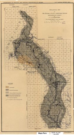
- Subject:
- Topical Subject: Limestone, Geographic Subject: Owen County (Ind.), Geographic Subject: Bloomington Region (Ind.), Geographic Subject: Greene County (Ind.), ...
- Creator:
- Indiana. Department of Geology and Natural Resources
- Publisher:
- Indiana. Department of Geology and Natural Resources
- Date Created:
- 1914
- Identifier:
- VAC3073-M-00351
- Genre:
- Topographic maps, Quadrangle maps, and Geological maps
- Geographic Location:
- Coordinates: W0864500 W0863000 N0391500 N0390000
- Related URL:
- Catalog URL: https://iucat.iu.edu/catalog/4896690
- Abstract:
- Relief shown by contours and spot heights. Contour interval 20 feet. Shows limestone locations in a portion of Monroe County and small portions of Owen and G...
- Call Number:
- G4093 .M7C5 1914 .I6
- Caption:
- Imprint: [Indianapolis] : Indiana Dept. of Geology [and Natural Resources], [1915] and Imprint: [Indianapolis] : [Wm. B. Burford], [1915]
- Physical Description:
- Dimensions: 45 x 35 cm and Scale: 1:62,500
- Alternate Identifier:
- Title Control Number: a4896690 and Alternate ID: 390726IP
- Persistent URL:
- https://purl.dlib.indiana.edu/iudl/images/VAC3073/VAC3073-M-00351
- Provenance:
- 39th Annual Report (1914) / Indiana. Department of Geology and Natural Resources.
-
- Subject:
- Topical Subject: Limestone, Topical Subject: Geology, Geographic Subject: Owen County (Ind.), Geographic Subject: Monroe County (Ind.), and Topical Subject: ...
- Creator:
- Siebenthal, C. E. (Claude Ellsworth), 1869-1930
- Publisher:
- Indiana. Department of Geology and Natural Resources
- Date Created:
- 1908
- Identifier:
- VAC3073-M-00288
- Genre:
- Geological maps
- Geographic Location:
- Coordinates: W0864640 W0861903 N0392814 N0385936
- Related URL:
- Catalog URL: https://iucat.iu.edu/catalog/18307460
- Abstract:
- Also shows location of lacustral, Mitchell limestone, and Harrodsburg limestone as well as those of abandoned quarries and the southern limit of glacial drif...
- Call Number:
- G4093.M7H5 1907 .S5
- Caption:
- Imprint: [Indianapolis] : [Indiana Dept. of Geology and Natural Resources], [1908]
- Physical Description:
- Scale: Approximately 1:126,720. 2 miles = 1 inches and Dimensions: 44 x 25 cm
- Alternate Identifier:
- Alternate ID: 390726IP and Title Control Number: a18307460
- Persistent URL:
- https://purl.dlib.indiana.edu/iudl/images/VAC3073/VAC3073-M-00288
- Provenance:
- 32nd Annual Report (1907) / Indiana. Department of Geology and Natural Resources.
