
Search Constraints
You searched for:
Date Created
1902
Remove constraint Date Created: 1902
Holding Location
B-WELLS
Remove constraint Holding Location: B-WELLS
Subject
Geographic Subject: Indiana
Remove constraint Subject: Geographic Subject: Indiana
1 - 8 of 8
Search Results
-
- Subject:
- Geographic Subject: Indiana and Topical Subject: IGS Annual Reports
- Publisher:
- Indiana. Department of Geology and Natural Resources
- Date Created:
- 1902
- Identifier:
- VAC3073-M-01575
- Genre:
- Index maps
- Geographic Location:
- Coordinates: W0880500 W0844700 N0414500 N0374600
- Related URL:
- Catalog URL: https://iucat.iu.edu/catalog/18418335
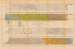
- Abstract:
- Index map showing locations covered by topographic maps represented on plates II-IV of the article. Shading indicates area covered by Topographic Section (Pl...
- Call Number:
- G4090 1901 .S5
- Caption:
- Imprint: [Indianapolis] : [Indiana Department of Geology and Natural Resources], [1902] and Imprint: [Indianapolis] : [Wm. B. Burford], [1902]
- Physical Description:
- Scale: Approximately 1:2,299,000 and Dimensions: on sheet 22 x 15 cm
- Alternate Identifier:
- Title Control Number: a18418335 and Alternate ID: 390726IP
- Persistent URL:
- https://purl.dlib.indiana.edu/iudl/images/VAC3073/VAC3073-M-01575
- Provenance:
- 26th Annual Report (1901) / Indiana. Department of Geology and Natural Resources.
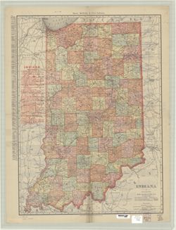
-
- Subject:
- Geographic Subject: Indiana
- Creator:
- Peale, R. S. (Richard S.)
- Publisher:
- Matthews-Northrup Company , J.N. Matthews Co.
- Date Created:
- 1902
- Identifier:
- VAC3073-M-00880
- Genre:
- Maps
- Geographic Location:
- Coordinates: W0880700 W0844500 N0414500 N0375200
- Related URL:
- Catalog URL: https://iucat.iu.edu/catalog/5166015
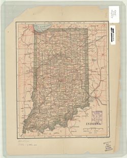
- Abstract:
- Shows counties, railroads, and place names. "6.02."
- Call Number:
- G4090 1902 .J586
- Caption:
- Imprint: New York : R.S. Peale, [1902]
- Physical Description:
- Dimensions: 28 x 22 cm and Scale: 1:1,647,369
- Alternate Identifier:
- Title Control Number: a5166015
- Persistent URL:
- https://purl.dlib.indiana.edu/iudl/images/VAC3073/VAC3073-M-00880
-
- Subject:
- Topical Subject: Mines and mineral resources, Topical Subject: Limestone, Topical Subject: Geology, Geographic Subject: Indiana, and Topical Subject: Geology...
- Creator:
- Newsom, John F. (John Flesher), 1869-1928
- Publisher:
- Indiana. Department of Geology and Natural Resources
- Date Created:
- 1902
- Identifier:
- VAC3073-M-00779
- Genre:
- Geological maps
- Geographic Location:
- Coordinates: W0863410 W0853500 N0390430 N0375720
- Related URL:
- Catalog URL: https://iucat.iu.edu/catalog/16077190
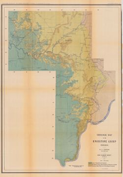
- Abstract:
- "Plate IV." Detached from: A geologic and topographic section across Southern Indiana / by J. F. Newsom. In Indiana Department of Geology and Na...
- Call Number:
- G4091.C5 1901 .N42
- Caption:
- Imprint: Indianapolis, Ind. : Wm. B. Burford, [1902] and Imprint: [Indianapolis] : Department of Geology and Natural Resources of Indiana, [1902]
- Physical Description:
- Scale: Scale approximately 1:190,080. 3 miles = 1 in. and Dimensions: 63 x 57 cm, on sheet 69 x 62 cm
- Alternate Identifier:
- Title Control Number: a16077190 and Alternate ID: 390726IP
- Persistent URL:
- https://purl.dlib.indiana.edu/iudl/images/VAC3073/VAC3073-M-00779
- Provenance:
- 26th Annual Report (1901) / Indiana. Department of Geology and Natural Resources.
-
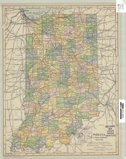
- Subject:
- Geographic Subject: Indiana
- Creator:
- Rand McNally and Company
- Publisher:
- Rand McNally and Company
- Date Created:
- 1902
- Identifier:
- VAC3073-M-00775
- Genre:
- Maps
- Geographic Location:
- Coordinates: W0880700 W0844500 N0414500 N0375200
- Related URL:
- Catalog URL: https://iucat.iu.edu/catalog/5176957
- Abstract:
- Relief shown by hachures. Includes index to cities and towns, with population, in left margin and index to railroads. On verso: index to Indiana counties, cr...
- Call Number:
- G4090 1902 .R36
- Caption:
- Imprint: Chicago : Rand McNally, 1902.
- Physical Description:
- Scale: 1:696,000 and Dimensions: 65 x 47 cm
- Alternate Identifier:
- Title Control Number: a5176957
- Persistent URL:
- https://purl.dlib.indiana.edu/iudl/images/VAC3073/VAC3073-M-00775
-
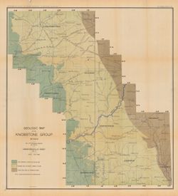
- Subject:
- Topical Subject: Geology, Geographic Subject: Indiana, and Topical Subject: Geology, Stratigraphic
- Creator:
- Newsom, John F. (John Flesher), 1869-1928
- Publisher:
- Indiana. Department of Geology and Natural Resources
- Date Created:
- 1902
- Identifier:
- VAC3073-M-00678
- Genre:
- Geological maps, Topographic maps, Strip maps, and Geological cross-sections
- Geographic Location:
- Coordinates: W0873650 W0852050 N0384430 N0383730
- Related URL:
- Catalog URL: https://iucat.iu.edu/catalog/16077374
- Abstract:
- Relief shown by contours. "Contour interval 40 feet." "Plate II." Detached from: A geologic and topographic section across Southern In...
- Call Number:
- G4091.C5 1901 .N41
- Caption:
- Imprint: Indianapolis, Ind. : Wm. B. Burford,[1902] and Imprint: [Indianapolis] : Department of Geology and Natural Resources of Indiana, [1902]
- Physical Description:
- Scale: Approximately 1:126,720. 2 miles = 1 in. Vertical scale approximately 1:24,000. 2,000 feet = 1 in. and Dimensions: 8 x 156 cm each, on sheet 56 x 84 cm
- Alternate Identifier:
- Title Control Number: a16077374 and Alternate ID: 390726IP
- Persistent URL:
- https://purl.dlib.indiana.edu/iudl/images/VAC3073/VAC3073-M-00678
- Provenance:
- 26th Annual Report (1901) / Indiana. Department of Geology and Natural Resources.
-
- Subject:
- Geographic Subject: Indiana
- Creator:
- Dodd, Mead & Company
- Publisher:
- Dodd, Mead & Company
- Date Created:
- 1902
- Identifier:
- VAC3073-M-00599
- Genre:
- Maps
- Geographic Location:
- Coordinates: W0880700 W0844500 N0414500 N0375200
- Related URL:
- Catalog URL: https://iucat.iu.edu/catalog/5166130
- Abstract:
- On verso: Area and population of Indiana by counties.
- Call Number:
- G4090 1902 .D63
- Caption:
- Imprint: [New York] : Dodd, Mead & Co., [1902]
- Physical Description:
- Dimensions: 26 x 21 cm and Scale: 1:1,700,000
- Alternate Identifier:
- Title Control Number: a5166130
- Persistent URL:
- https://purl.dlib.indiana.edu/iudl/images/VAC3073/VAC3073-M-00599
-
- Subject:
- Topical Subject: Mines and mineral resources, Topical Subject: Geology, Geographic Subject: Indiana, Topical Subject: Geology, Stratigraphic, and Topical Sub...
- Creator:
- Newsom, John F. (John Flesher), 1869-1928
- Publisher:
- Indiana. Department of Geology and Natural Resources
- Date Created:
- 1902
- Identifier:
- VAC3073-M-00381
- Genre:
- Geological maps
- Geographic Location:
- Coordinates: W0863410 W0853500 N0390430 N0375720
- Related URL:
- Catalog URL: https://iucat.iu.edu/catalog/16077083
- Abstract:
- Relief shown by contour lines. "Plate III." Detached from: A geologic and topographic section across Southern Indiana / by J. F. Newsom. In Indi...
- Call Number:
- G4091.C5 1901 .N43
- Caption:
- Imprint: [Indianapolis, Ind.] : [Indiana Department of Geology and Natural Resources], [1901] and Imprint: Indianapolis, Ind. : Wm. B. Burford, [1902]
- Physical Description:
- Scale: Scale approximately 1:190,080. 3 miles = 1 in. and Dimensions: 69 x 49 cm, on sheet 76 x 52 cm
- Alternate Identifier:
- Title Control Number: a16077083 and Alternate ID: 390726IP
- Persistent URL:
- https://purl.dlib.indiana.edu/iudl/images/VAC3073/VAC3073-M-00381
- Provenance:
- 26th Annual Report (1901) / Indiana. Department of Geology and Natural Resources.
-
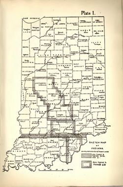
- Subject:
- Topical Subject: Geology, Stratigraphic, Topical Subject: IGS Annual Reports, Geographic Subject: Indiana, and Topical Subject: Watersheds
- Creator:
- Newsom, John F. (John Flesher), 1869-1928
- Publisher:
- Indiana. Department of Geology and Natural Resources
- Date Created:
- 1902
- Identifier:
- VAC3073-M-00234
- Genre:
- Thematic maps and Geological cross-sections
- Geographic Location:
- Coordinates: W0880500 W0844700 N0395100 N0374600
- Related URL:
- Catalog URL: https://iucat.iu.edu/catalog/18279215
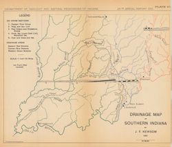
- Abstract:
- Shows eastern, central, and western drainage areas in southern Indiana, the southern limit of the ice front after Leverett, and geological cross-sections in ...
- Call Number:
- G4091.C315 1901 .N49
- Caption:
- Imprint: Indianapolis, Ind. : Wm. B. Burford, Lith., [1902]
- Physical Description:
- Dimensions: on sheet 22 x 26 cm and Scale: Approximately 1:1,267,200. 1 inch = 20 miles
- Alternate Identifier:
- Alternate ID: 390726IP and Title Control Number: a18279215
- Persistent URL:
- https://purl.dlib.indiana.edu/iudl/images/VAC3073/VAC3073-M-00234
- Provenance:
- 26th Annual Report (1901) / Indiana. Department of Geology and Natural Resources.
