
Search Constraints
You searched for:
Date Created
1898
Remove constraint Date Created: 1898
Publisher
Indiana. Department of Geology and Natural Resources
Remove constraint Publisher: Indiana. Department of Geology and Natural Resources
1 - 7 of 7
Search Results
-
- Subject:
- Geographic Subject: Perry County (Ind.), Geographic Subject: Spencer County (Ind.), Topical Subject: Coal, and Geographic Subject: Warrick County (Ind.)
- Creator:
- Ashley, Geo. H. (George Hall), 1866-1951, Kindle, E. M. (Edward Martin), 1869-1940, and Price, J. A.
- Publisher:
- Indiana. Department of Geology and Natural Resources
- Date Created:
- 1898
- Identifier:
- VAC3073-M-01185
- Genre:
- Geological maps
- Geographic Location:
- Coordinates: W0872823 W0862942 N0381446 N0374639
- Related URL:
- Catalog URL: https://iucat.iu.edu/catalog/9160352
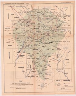
- Abstract:
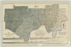
- By George H. Ashley, assistant geologist, Department of Geology and Natural Resources of Indiana, W.S. Blatchley, state geologist , geology by G.H. Ashley, J...
- Call Number:
- G4093.W4H9 1898 .A8
- Caption:
- Imprint: Indianapolis : Burford, [1899] and Imprint: [Indianapolis, Ind.] : Dept. of Geology and Natural Resources of Indiana, [1899]
- Physical Description:
- Dimensions: 46 x 76 cm and Scale: 1:31,680
- Persistent URL:
- https://purl.dlib.indiana.edu/iudl/images/VAC3073/VAC3073-M-01185
- Provenance:
- 23rd Annual Report (1898) / Indiana. Department of Geology and Natural Resources.
-
- Subject:
- Topical Subject: Mines and mineral resources, Topical Subject: Geology, Topical Subject: IGS Annual Reports, Geographic Subject: Perry County (Ind.), and Top...
- Publisher:
- Indiana. Department of Geology and Natural Resources
- Date Created:
- 1898
- Identifier:
- VAC3073-M-00991
- Genre:
- Geological maps and Geological cross-sections
- Geographic Location:
- Coordinates: W0864825 W0863629 N0380227 N0375602
- Related URL:
- Catalog URL: https://iucat.iu.edu/catalog/18349350
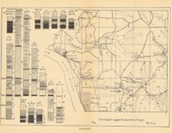
- Abstract:
- ncludes index map and 16 stratigraphic columns showing coal measurements. Plate LXVII. "Troy. Tell City." Detached from: Seventh annual report o...
- Call Number:
- G4093.P2H9 1876 .T69
- Caption:
- Imprint: [Indianapolis] : [Sentinel Company, printers], [1876] and Imprint: [Indianapolis] : [Geological Survey of Indiana], [1876]
- Physical Description:
- Scale: Approximately 1:63,360. Vertical scale indeterminable and Dimensions: on sheet 21 x 26 cm
- Alternate Identifier:
- Title Control Number: a18349350 and Alternate ID: 390726IP
- Persistent URL:
- https://purl.dlib.indiana.edu/iudl/images/VAC3073/VAC3073-M-00991
- Provenance:
- 7th Annual Report (1875) / Indiana. Geological Survey.
-
- Subject:
- Geographic Subject: Lake County (Ind.), Topical Subject: IGS Annual Reports, Geographic Subject: Porter County (Ind.), Topical Subject: Geology, and Topical ...
- Creator:
- Ashley, Geo. H. (George Hall), 1866-1951
- Publisher:
- Indiana. Department of Geology and Natural Resources
- Date Created:
- 1898
- Identifier:
- VAC3073-M-00806
- Genre:
- Geological maps
- Geographic Location:
- Coordinates: W0873136 W0865435 N0414259 N0410943
- Related URL:
- Catalog URL: https://iucat.iu.edu/catalog/17035654
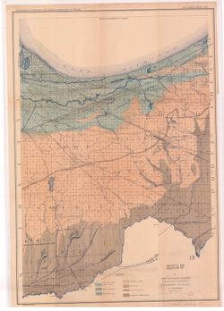
- Abstract:
- Shows lakes, beaches, sand-dune area, morainic area, till plains, crest of moraine, and Kankakee Marsh area. Detached from: The geology of Lake and Porter...
- Call Number:
- G4093.L3C5 1897 .A8
- Caption:
- Imprint: [Indianapolis] : Department of Geology and Natural Resources of Indiana, [1898] and Imprint: Indianapolis, Ind. : Wm. B. Burford, lith., [1898]
- Physical Description:
- Dimensions: 55 x 42 cm and Scale: Approximately 1:126,720. 2 miles = 1 inch
- Alternate Identifier:
- Title Control Number: a17035654 and Alternate ID: 390726IP
- Persistent URL:
- https://purl.dlib.indiana.edu/iudl/images/VAC3073/VAC3073-M-00806
- Provenance:
- 22nd Annual Report (1897) / Indiana. Department of Geology and Natural Resources.
-
- Subject:
- Geographic Subject: Franklin County (Ind.), Topical Subject: Geology, Topical Subject: IGS Annual Reports, and Geographic Subject: Decatur County (Ind.)
- Creator:
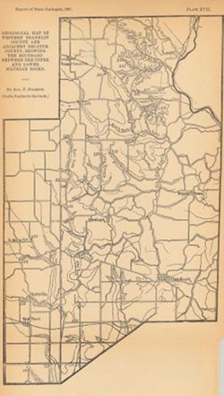
- Foerste, Aug. F. (Aug. Frederic), 1862-1936
- Publisher:
- Indiana. Department of Geology and Natural Resources
- Date Created:
- 1898
- Identifier:
- VAC3073-M-00631
- Genre:
- Geological maps
- Geographic Location:
- Coordinates: W0852152 W0850747 N0393129 N0391606
- Related URL:
- Catalog URL: https://iucat.iu.edu/catalog/17227850
- Abstract:
- Plate XVII. "Report of State Geologist, 1897, plate xvii." Detached from: A report on the Niagara limestone quarries of Decatur, Franklin and...
- Call Number:
- G4093.F7C5 1897 .F64
- Caption:
- Imprint: [Indianapolis] : [Wm. B. Burford], [1898] and Imprint: [Indianapolis] : [Indiana Department of Geology and Natural Resources], [1898]
- Physical Description:
- Scale: Approximately 1:126,720. 2 miles = 1 inch and Dimensions: 25 x 15 cm
- Alternate Identifier:
- Title Control Number: a17227850 and Alternate ID: 390726IP
- Persistent URL:
- https://purl.dlib.indiana.edu/iudl/images/VAC3073/VAC3073-M-00631
- Provenance:
- 22nd Annual Report (1897) / Indiana. Department of Geology and Natural Resources.
-
- Subject:
- Geographic Subject: Indiana, Topical Subject: Gas wells, Topical Subject: Gas fields, Topical Subject: Gas pipelines, Topical Subject: Oil wells, and Topical...
- Creator:
- Leach, J. C.
- Publisher:
- Indiana. Department of Geology and Natural Resources
- Date Created:
- 1898
- Identifier:
- VAC3073-M-00627
- Genre:
- Geological maps
- Geographic Location:
- Coordinates: W0863600 W0844800 N0404900 N0390900
- Related URL:
- Catalog URL: https://iucat.iu.edu/catalog/18225077
- Abstract:
- Shows original gas territory, gas wells, pipe lines, pumping stations, oil wells, and limits of territory at present producing gas in east-central Indiana. ...
- Call Number:
- G4091.H8 1897 .L4
- Caption:
- Imprint: Indianapolis, Ind. : Wm. B. Burford, lith., [1898] and Imprint: [Indianapolis?] : Dept. of Geology and Natural Resources of Indiana, [1897]
- Physical Description:
- Scale: Approximately 1:576,000 and Dimensions: 53 x 42 cm
- Alternate Identifier:
- Alternate ID: 390726IP and Title Control Number: a18225077
- Persistent URL:
- https://purl.dlib.indiana.edu/iudl/images/VAC3073/VAC3073-M-00627
- Provenance:
- 22nd Annual Report (1897) / Indiana. Department of Geology and Natural Resources.
-
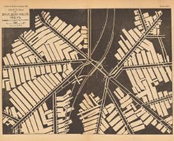
- Subject:
- Geographic Subject: Clay County (Ind.), Topical Subject: IGS Annual Reports, Topical Subject: Coal mines and mining, and Topical Subject: Brazil Block Coal C...
- Creator:
- Mooney, P. J. and Ashley, Geo. H. (George Hall), 1866-1951
- Publisher:
- Indiana. Department of Geology and Natural Resources
- Date Created:
- 1898
- Identifier:
- VAC3073-M-00271
- Genre:
- Mine maps
- Geographic Location:
- Coordinates: W0870943 W0870728 N0393621 N0393534
- Related URL:
- Catalog URL: https://iucat.iu.edu/catalog/18244670
- Abstract:
- Plate XIX. Planned and laid out by P.J. Mooney , drawn by G.H.A. Detached from: The coal deposits of Indiana / George Hall Ashley. In Indiana Dept. of Geo...
- Call Number:
- G4093.C5H9 1898 .A8
- Caption:
- Imprint: [Indianapolis] : [Dept. of Geology and Natural Resources of Indiana], [1899]
- Physical Description:
- Dimensions: 22 x 26 cm and Scale: Approximately 1:2,400
- Alternate Identifier:
- Title Control Number: a18244670 and Alternate ID: 390726IP
- Persistent URL:
- https://purl.dlib.indiana.edu/iudl/images/VAC3073/VAC3073-M-00271
- Provenance:
- 23rd Annual Report (1898) / Indiana. Department of Geology and Natural Resources.
-
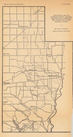
- Subject:
- Topical Subject: Mines and mineral resources, Topical Subject: Geology, Geographic Subject: Fayette County (Ind.), and Topical Subject: IGS Annual Reports
- Creator:
- Foerste, Aug. F. (Aug. Frederic), 1862-1936
- Publisher:
- Indiana. Department of Geology and Natural Resources
- Date Created:
- 1898
- Identifier:
- VAC3073-M-00063
- Genre:
- Geological maps
- Geographic Location:
- Coordinates: W0851831 W0850639 N0394639 N0393044
- Related URL:
- Catalog URL: https://iucat.iu.edu/catalog/17035593
- Abstract:
- Plate XVIII. Detached from: A report on the Niagara limestone quarries of Decatur, Franklin and Fayette Counties ... / August F. Foerste. In Indiana Departme...
- Call Number:
- G4093.F3C5 1898 .F64
- Caption:
- Imprint: [Indianapolis] : [Wm. B. Burford], [1898] and Imprint: [Indiana] : [Department of Geology and Natural Resources], [1898]
- Physical Description:
- Scale: Approximately 1:126,720 and Dimensions: 26 x 14 cm
- Alternate Identifier:
- Title Control Number: a17035593 and Alternate ID: 390726IP
- Persistent URL:
- https://purl.dlib.indiana.edu/iudl/images/VAC3073/VAC3073-M-00063
- Provenance:
- 22nd Annual Report (1897) / Indiana. Department of Geology and Natural Resources.
