
Search Constraints
Search Results
-
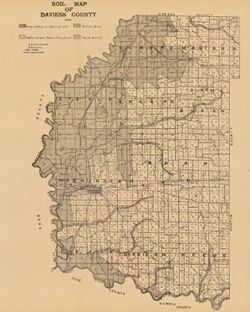
- Subject:
- Geographic Subject: Daviess County (Ind.) and Topical Subject: Soils
- Creator:
- Indiana. Department of Geology and Natural Resources
- Publisher:
- [Indiana Department of Geology and Natural Resources]
- Date Created:
- 1909
- Identifier:
- VAC3073-M-00883
- Genre:
- Thematic maps
- Geographic Location:
- Coordinates: W0871645 W0865414 N0385415 N0382925
- Related URL:
- Catalog URL: https://iucat.iu.edu/catalog/16124707
- Abstract:
- Shows school houses, churches, roads, and railroads. Detached from: A soil survey of four counties of southern Indiana / Chas. W. Shannon and L.C. Snider....
- Call Number:
- G4093.D2J3 1908 .I53
- Caption:
- Imprint: [Indianapolis] : [Indiana Department of Geology and Natural Resources], [1909]
- Physical Description:
- Dimensions: 41 x 33 cm and Scale: Approximately 1:126,720
- Alternate Identifier:
- Alternate ID: 390726IP and Title Control Number: a16124707
- Persistent URL:
- https://purl.dlib.indiana.edu/iudl/images/VAC3073/VAC3073-M-00883
- Provenance:
- 33rd Annual Report (1908) / Indiana. Department of Geology and Natural Resources.
-
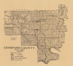
- Subject:
- Topical Subject: IGS Annual Reports, Topical Subject: Soils, and Geographic Subject: Crawford County (Ind.)
- Creator:
- Shannon, C. W. (Charles William), 1879-1934
- Publisher:
- Indiana. Department of Geology and Natural Resources
- Date Created:
- 1909
- Identifier:
- VAC3073-M-00856
- Genre:
- Thematic maps
- Geographic Location:
- Coordinates: W0864052 W0861444 N0382520 N0380617
- Related URL:
- Catalog URL: https://iucat.iu.edu/catalog/16091037
- Abstract:
- Shows school houses, caves, public roads, and railroads. Detached from: A soil survey of four counties of southern Indiana / Chas. W. Shannon and L.C. Sni...
- Call Number:
- G4093.C7J3 1908 .I53
- Caption:
- Imprint: [Indianapolis] : [Wm. B. Burford], [1909] and Imprint: [Indianapolis] : [Indiana Department of Geology and Natural Resources], [1909]
- Physical Description:
- Scale: Approximately 1:130,000 and Dimensions: on sheet 32 x 36 cm
- Alternate Identifier:
- Title Control Number: a16091037 and Alternate ID: 390726IP
- Persistent URL:
- https://purl.dlib.indiana.edu/iudl/images/VAC3073/VAC3073-M-00856
- Provenance:
- 33rd Annual Report (1908) / Indiana. Department of Geology and Natural Resources.
-
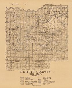
- Subject:
- Topical Subject: Soils and Geographic Subject: Dubois County (Ind.)
- Creator:
- Indiana. Department of Geology and Natural Resources
- Publisher:
- Indiana. Department of Geology and Natural Resources
- Date Created:
- 1909
- Identifier:
- VAC3073-M-00808
- Genre:
- Thematic maps
- Geographic Location:
- Coordinates: W0870420 W0864048 N0383133 N0381222
- Related URL:
- Catalog URL: https://iucat.iu.edu/catalog/16091036
- Abstract:
- Shows school houses, public roads, and railroads. Detached from: A soil survey of four counties of southern Indiana / Chas. W. Shannon and L.C. Snider. In...
- Call Number:
- G4093.D8J3 1908 .I53
- Caption:
- Imprint: [Indianapolis] : [Indiana Department of Geology and Natural Resources], [1909]
- Physical Description:
- Scale: Approximately 1:126,720 and Dimensions: 39 x 33 cm
- Alternate Identifier:
- Title Control Number: a16091036 and Alternate ID: 390726IP
- Persistent URL:
- https://purl.dlib.indiana.edu/iudl/images/VAC3073/VAC3073-M-00808
- Provenance:
- 33rd Annual Report (1908) / Indiana. Department of Geology and Natural Resources.
-
- Subject:
- Topical Subject: Coal, Topical Subject: Geology, Stratigraphic, Topical Subject: IGS Annual Reports, and Geographic Subject: Indiana
- Creator:
- Ashley, Geo. H. (George Hall), 1866-1951
- Publisher:
- Indiana. Department of Geology and Natural Resources
- Date Created:
- 1909
- Identifier:
- VAC3073-M-00650
- Genre:
- Geological cross-sections
- Geographic Location:
- Coordinates: W0880500 W0844700 N0414500 N0374600
- Related URL:
- Catalog URL: https://iucat.iu.edu/catalog/18307698
- Abstract:
- 15 sections on one sheet. Detached from: The coal deposits of Indiana : a supplemental report to the one issued in 1898 / George H. Ashley. In Indiana Dep...
- Call Number:
- QE109 .A2 1908
- Caption:
- Imprint: [Indianapolis] : [Indiana Department of Geology and Natural Resources], [1909]
- Physical Description:
- Dimensions: 44 x 53 cm and Scale: Approximately 1:126,720. 2 miles = 1 inch. Vertical scale approximately 1:12,000. 1,000 feet = 1 inch
- Alternate Identifier:
- Title Control Number: a18307698 and Alternate ID: 390726IP
- Persistent URL:
- https://purl.dlib.indiana.edu/iudl/images/VAC3073/VAC3073-M-00650
- Provenance:
- 33rd Annual Report (1908) / Indiana. Department of Geology and Natural Resources.
-
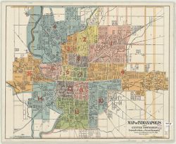
- Subject:
- Geographic Subject: Center (Marion County, Ind. : Township), Geographic Subject: Indianapolis (Ind.), and Topical Subject: Administrative and political divis...
- Creator:
- Palmer, Thos. W. (Thomas W.)
- Publisher:
- Sentinel Printing Co.
- Date Created:
- 1909
- Identifier:
- VAC3073-M-00411
- Genre:
- Thematic maps
- Geographic Location:
- Coordinates: W0860929 W0860929 N0394606 N0394606
- Related URL:
- Catalog URL: https://iucat.iu.edu/catalog/4681859
- Call Number:
- G4094 .I4F7 1909 .P35
- Caption:
- Imprint: Indianapolis : Sentinel Printing Co., [1909]
- Physical Description:
- Scale: 1:15,840 and Dimensions: 73 x 91 cm
- Alternate Identifier:
- Title Control Number: CAT8138BB
- Persistent URL:
- https://purl.dlib.indiana.edu/iudl/images/VAC3073/VAC3073-M-00411
-
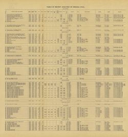
- Subject:
- Geographic Subject: Clay County (Ind.), Topical Subject: IGS Annual Reports, Topical Subject: Coal, Topical Subject: Mines and mineral resources, Geographic ...
- Creator:
- Ashley, Geo. H. (George Hall), 1866-1951
- Publisher:
- Indiana. Department of Geology and Natural Resources
- Date Created:
- 1909
- Identifier:
- VAC3073-M-00359
- Genre:
- Tables (Data) and Charts
- Related URL:
- Catalog URL: https://iucat.iu.edu/catalog/4022271
- Abstract:
- Detached from: The coal deposits of Indiana : a supplemental report to the one issued in 1898 / by Beorge H. Ashley. In Indiana Department of Geology and Nat...
- Call Number:
- QE109 .A2 1908 map p144
- Caption:
- Imprint: Indianapolis : 1909
- Physical Description:
- Dimensions: 40 x 38 cm
- Alternate Identifier:
- Title Control Number: 390726IP
- Persistent URL:
- https://purl.dlib.indiana.edu/iudl/images/VAC3073/VAC3073-M-00359
- Provenance:
- 33rd Annual Report (1908) / Indiana. Department of Geology and Natural Resources.
-
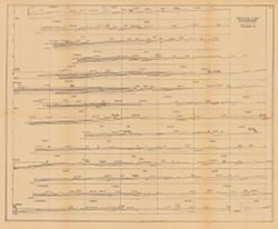
Coal chart : Indiana measures showing thickness, partings, roof and floor of the principal coal beds
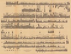
- Subject:
- Topical Subject: Coal, Geographic Subject: Indiana, Topical Subject: Startigraphic correlation, Topical Subject: Geology, Stratigraphic, and Topical Subject:...
- Creator:
- Ashley, Geo. H. (George Hall), 1866-1951
- Publisher:
- Indiana. Department of Geology and Natural Resources
- Date Created:
- 1909
- Identifier:
- VAC3073-M-00243
- Genre:
- Geological cross-sections
- Geographic Location:
- Coordinates: W0880500 W0844700 N0414500 N0374600
- Related URL:
- Catalog URL: https://iucat.iu.edu/catalog/18307674
- Abstract:
- Includes several hundred stratigraphic columns showing coal measurements for sites across Indiana and correlation lines. Detached from: The coal deposits ...
- Call Number:
- G4091.C57 1907 .C63
- Caption:
- Imprint: [Indianapolis] : [Indiana Department of Geology and Natural Resources], [1909]
- Physical Description:
- Dimensions: 41 x 54 cm and Scale: Horizontal scale not given. Vertical scale approximately 1:12. 1 inch = 8 feet
- Alternate Identifier:
- Title Control Number: a18307674 and Alternate ID: 390726IP
- Persistent URL:
- https://purl.dlib.indiana.edu/iudl/images/VAC3073/VAC3073-M-00243
- Provenance:
- 33rd Annual Report (1908) / Indiana. Department of Geology and Natural Resources.
-
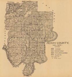
- Subject:
- Geographic Subject: Perry County (Ind.) and Topical Subject: Soils
- Creator:
- Indiana. Department of Geology and Natural Resources
- Publisher:
- Indiana. Department of Geology and Natural Resources
- Date Created:
- 1909
- Identifier:
- VAC3073-M-00164
- Genre:
- Thematic maps
- Geographic Location:
- Coordinates: W0864853 W0862548 N0381558 N0375029
- Related URL:
- Catalog URL: https://iucat.iu.edu/catalog/16123915
- Abstract:
- Shows school houses, public roads, and railroads. Detached from: A soil survey of four counties of southern Indiana / Chas. W. Shannon and L.C. Snider. In...
- Call Number:
- G4093.P3J3 1908 .I53
- Caption:
- Imprint: [Indianapolis] : [Indiana Department of Geology and Natural Resources], [1909]
- Physical Description:
- Dimensions: 41 x 38 cm and Scale: Approximately 1:126,720
- Alternate Identifier:
- Alternate ID: 390726IP and Title Control Number: a16123915
- Persistent URL:
- https://purl.dlib.indiana.edu/iudl/images/VAC3073/VAC3073-M-00164
- Provenance:
- 33rd Annual Report (1908) / Indiana. Department of Geology and Natural Resources.
-
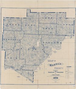
- Subject:
- Geographic Subject: Warrick County (Ind.), Topical Subject: Real property, and Topical Subject: Landowners
- Creator:
- Wilke, John H.
- Publisher:
- Wilke, John H.
- Date Created:
- 1909
- Identifier:
- VAC3073-M-00157
- Genre:
- Cadastral maps
- Geographic Location:
- Coordinates: W0873200 W0870100 N0381400 N0375200
- Related URL:
- Catalog URL: https://iucat.iu.edu/catalog/5382911
- Abstract:
- Cadastral map showing landowners. "Based on public and private surveys and records, etc." Blue line print. "Entered according to A...
- Call Number:
- G4093.W4 G46 1909 .W55
- Caption:
- Imprint: [Boonville, Ind.] : John H. Wilke, 1909
- Physical Description:
- Dimensions: 135 x 132 cm and Scale: 1:31,680
- Alternate Identifier:
- Title Control Number: a5382911
- Persistent URL:
- https://purl.dlib.indiana.edu/iudl/images/VAC3073/VAC3073-M-00157
-
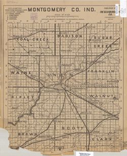
- Subject:
- Geographic Subject: Montgomery County (Ind.)
- Creator:
- Scarborough Company
- Publisher:
- Scarborough Company
- Date Created:
- 1909
- Identifier:
- VAC3073-M-00102
- Genre:
- Maps
- Geographic Location:
- Coordinates: W0870600 W0864200 N0401300 N0395200
- Related URL:
- Catalog URL: https://iucat.iu.edu/catalog/4675934
- Call Number:
- G4093 .M8 1909 .S283
- Caption:
- Imprint: Indianapolis, IN: Scarborough Co., 1909.
- Physical Description:
- Scale: 1:80,000 and Dimensions: 57 x 46 cm
- Alternate Identifier:
- Title Control Number: CAQ3236BB
- Persistent URL:
- https://purl.dlib.indiana.edu/iudl/images/VAC3073/VAC3073-M-00102
