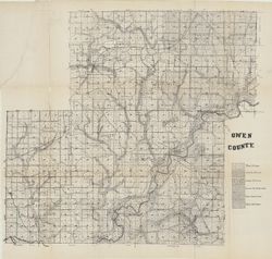
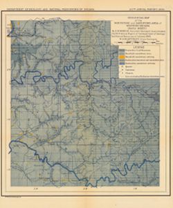
Shows soil types. Also shows roads and railroads. Detached from: Soil survey of Owen County / J.B. Edmondson. In Thirty-sixth annual report of Department ...
Call Number:
G4093.O8J3 1911 .I53
Caption:
Imprint: [Indianapolis] : [Wm. B. Burford], [1912] and Imprint: [Indianapolis] : [Department of Geology and Natural Resources, Indiana], [1912]
Physical Description:
Scale: Approximately 1:63,360 and Dimensions: 59 x 65 cm
Alternate Identifier:
Title Control Number: a16096159 and Alternate ID: 390726IP
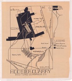
Shows active quarries, mill and tramway, worked areas, and railways in Oolitic, Indiana. Detached from: The Indiana oolitic limestone industry in 1907 / R...
Call Number:
G4094.O5H5 1908 .H66
Caption:
Imprint: [Indianapolis] : [Indiana Department of Geology and Natural Resources], [1908]
Physical Description:
Dimensions: on sheet 26 x 23 cm and Scale: Scale not given.
Alternate Identifier:
Title Control Number: a18307486 and Alternate ID: 390726IP
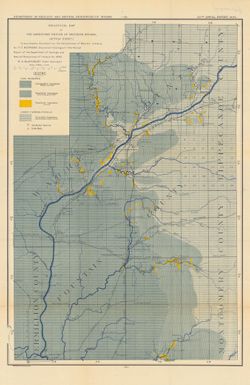
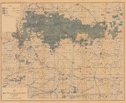
"January 1, 1901." Shows good, fair, and light oil territory, gas wells, dry and salt water territory, undrilled area, and pumping stations. Det...
Call Number:
G4091.H8 1900 .B5
Caption:
Imprint: [Indianapolis] : Department of Geology and Natural Resources of Indiana, [1901] and Imprint: Indianapolis, Ind. : Wm. B. Burford, [1901]
Physical Description:
Dimensions: 33 x 60 cm and Scale: Scale approximately 1:126,720. 2 miles = 1 in.
Alternate Identifier:
Alternate ID: 390726IP and Title Control Number: a16078449
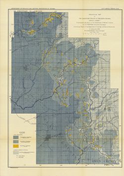
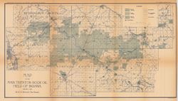
"January 1, 1904." Shows good, fair, and light oil territory, gas territory, dry or salt water territory, and pumping stations. Detached from: T...
Call Number:
G4091.H8 1903 .B5
Caption:
Imprint: [Indianapolis] : Department of Geology and Natural Resources of Indiana,[1904] and Imprint: Indianapolis, Ind. : Wm. B. Burford, [1904]
Physical Description:
Dimensions: 53 x 67 cm, folded to 22 x 12 cm and Scale: Approximately Scale 1:126,720. 2 miles = 1 in.
Alternate Identifier:
Alternate ID: 390726IP and Title Control Number: a16077757
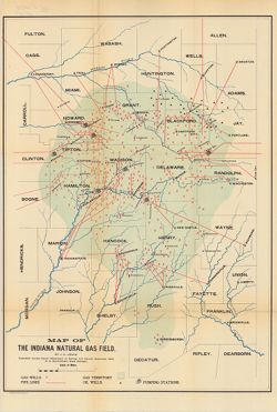
Topical Subject: IGS Annual Reports, Topical Subject: Gas fields, Topical Subject: Gas wells, Geographic Subject: Indiana, Topical Subject: Oil wells, and To...
Creator:
Leach, J. C.
Publisher:
Indiana. Department of Geology and Natural Resources
Date Created:
1896
Identifier:
VAC3073-M-01064
Genre:
Geological maps
Geographic Location:
Coordinates: W0864100 W0844800 N0410000 N0390500
Related URL:
Catalog URL: https://iucat.iu.edu/catalog/4022271
Abstract:
Shows gas wells, pipelines, pumping stations, and oil wells in east-central Indiana. Detached from: Report of the State Natural Gas Supervisor / J.C. Leac...
Call Number:
G4091.H8 1895 .L4
Caption:
Imprint: Indianapolis, Ind. : Wm. B. Burford, Lith., [1896]
Physical Description:
Dimensions: 56 x 39 cm and Scale: Approximately 1:434,000
Alternate Identifier:
Title Control Number: a18225037 and Alternate ID: 390726IP
Detached from: The carboniferous sandstones of western Indiana / T.C. Hopkins. In Indiana Dept. of Geology and Natural Resources twentieth annual report. Ind...
Call Number:
G4094.A6C5 1895 .G4
Caption:
Imprint: Indianapolis : Wm. B. Burford, 1896.
Physical Description:
Scale: Approximately 1:126,720. 2 miles = 1 inch and Dimensions: 47 x 32 cm
Alternate Identifier:
Alternate ID: 390726IP and Title Control Number: a17228652
Detached from: The carboniferous sandstones of western Indiana / T.C. Hopkins. In Indiana Dept. of Geology and Natural Resources twentieth annual report. Ind...
Call Number:
G4094.B7C5 1895 .G4
Caption:
Imprint: Indianapolis : Wm. B. Burford, 1896.
Physical Description:
Dimensions: 53 x 38 cm and Scale: Approximately 1:126,720. 2 miles = 1 inch
Alternate Identifier:
Title Control Number: a18175494 and Alternate ID: 390726IP
Topical Subject: IGS Annual Reports, Topical Subject: Mines and mineral resources, Topical Subject: Church buildings, Topical Subject: Geology, and Geographi...
Creator:
Kindle, E. M. (Edward Martin), 1869-1940
Publisher:
Indiana. Department of Geology and Natural Resources
Shows the locations of coal, sandstone, and limestone areas as well as the locations of quarries, coal mines, and churches. Detached from: The carbonifero...
Call Number:
G4093.O6H1 1895 .K56
Caption:
Imprint: Indianapolis, Ind. : Wm. B. Burford, Lith., 1896
Physical Description:
Scale: Approximately 1:126,720. 2 miles = 1 inch and Dimensions: 33 x 27 cm
Alternate Identifier:
Title Control Number: a18175514 and Alternate ID: 390726IP
"Boundary after Foerste." Detached from: The stratigraphy and paleontology of the Cincinnati series of Indiana / E.R. Cumings. In Indiana Dept. ...
Call Number:
G4091.C57 1908 .M3
Caption:
Imprint: [Indianapolis] : [Indiana Dept. of Geology and Natural Resources], [1908]
Physical Description:
Dimensions: on sheet 60 x 51 cm and Scale: Approximately 1:126,720. 2 miles to the 1 inch
Alternate Identifier:
Title Control Number: a18307520 and Alternate ID: 390726IP