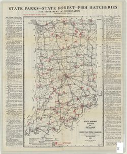
Topical Subject: Parks, Topical Subject: Roads, and Geographic Subject: Indiana
Creator:
Indiana. Department of Conservation
Publisher:
Indiana. State Highway Commission (1919-1953)
Date Created:
1924
Identifier:
VAC3073-M-01238
Genre:
Tourist maps
Geographic Location:
Coordinates: W0880500 W0844700 N0414500 N0374600
Related URL:
Catalog URL: https://iucat.iu.edu/catalog/4040824
Abstract:
Compiled by Chas. G. Sauers. Map title: Map of Indiana showing points of interest and state highways. "Map furnished by Indiana State Highway Commission...
Call Number:
G4091 .E635 1924 .I6
Caption:
Imprint: [Indianapolis] : The Department of Conservation, 1924
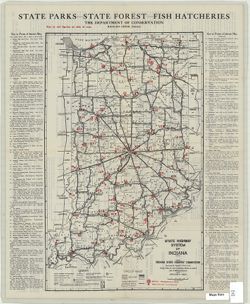
Geographic Subject: Indiana, Topical Subject: Parks, and Topical Subject: Roads
Creator:
Indiana. Department of Conservation
Publisher:
Indiana. State Highway Commission (1919-1953)
Date Created:
1925
Identifier:
VAC3073-M-01237
Genre:
Tourist maps
Geographic Location:
Coordinates: W0880500 W0844700 N0414500 N0374600
Related URL:
Catalog URL: https://iucat.iu.edu/catalog/1204523
Abstract:
Map title: Map of Indiana showing points of interest and state highways. "Map furnished by Indiana State Highway Commission, R.F. Pickens, del." On...
Call Number:
G4091.E635 1925 .I6
Caption:
Imprint: [Indianapolis] : The Department of Conservation, [approximately 1925]
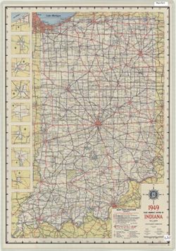
Panel title: 1949 Indiana official highway map. Relief shown by spot heights. Includes 8 local route maps. Index, distance chart, distance map of the United ...
Call Number:
G1403 .S7 1949
Caption:
Imprint: [Indianapolis] : State Highway Commission, [1949]
Physical Description:
Dimensions: 94 x 59 cm and Scale: Approximately 1:633,600
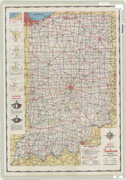
Panel title: 1952 Indiana official highway map. Relief shown by spot heights. Includes text, color illustrations, and 5 local route maps. Index, distance cha...
Call Number:
G1403 .S7 1952
Caption:
Imprint: [Indianapolis] : State Highway Commission, [1952]
Physical Description:
Dimensions: 94 x 59 cm and Scale: Approximately 1:633,600
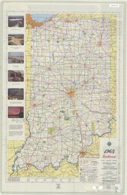
Panel title: 1964 Indiana official highway map. Relief shown by spot heights. Includes text, list of state highway garages, and color illustrations. Index, d...
Call Number:
G1403.S7 1964
Caption:
Imprint: [Indianapolis] : State Highway Commission, [1964]
Physical Description:
Dimensions: 94 x 59 cm and Scale: Approximately 1:633,600
Geographic Subject: Monroe County (Ind.) and Topical Subject: Roads
Creator:
Indiana. State Highway Commission (1919-1953)
Publisher:
Indiana. State Highway Commission (1919-1953)
Date Created:
1937
Identifier:
VAC3073-M-00994
Genre:
Road maps
Geographic Location:
Coordinates: W0864100 W0861900 N0392100 N0390000
Related URL:
Catalog URL: https://iucat.iu.edu/catalog/5706988
Abstract:
Blueline. "1937." "53." "Corrected to January 1, 1937." Includes location map and chart of "Culture in unincorporated plac...
Call Number:
G4093.M7P2 1937 .I52
Caption:
Imprint: [Indianapolis] : State Highway Commission of Indiana, 1937.
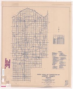
Topical Subject: Roads and Geographic Subject: Jasper County (Ind.)
Creator:
Indiana. State Highway Commission (1919-1953)
Publisher:
Indiana. State Highway Commission (1919-1953)
Date Created:
1937
Identifier:
VAC3073-M-00993
Genre:
Road maps
Geographic Location:
Coordinates: W0871700 W0865600 N0411700 N0404400
Related URL:
Catalog URL: https://iucat.iu.edu/catalog/5362493
Abstract:
Blue line print. "Corrected to January 1, 1937." "Data obtained from State-wide Highway Planning Survey." Includes chart "Culture in...
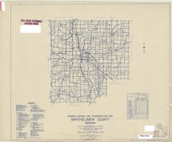
Topical Subject: Roads and Geographic Subject: Bartholomew County (Ind.)
Creator:
Indiana. State Highway Commission (1919-1953)
Publisher:
Indiana. State Highway Commission (1919-1953)
Date Created:
1949
Identifier:
VAC3073-M-00950
Genre:
Road maps
Geographic Location:
Coordinates: W0860500 W0844100 N0392100 N0390200
Related URL:
Catalog URL: https://iucat.iu.edu/catalog/5359878
Abstract:
Blue line print. "State roads revised January 1, 1949." "1937." "Data obtained from State-wide Highway Planning Survey." "...
Call Number:
G4093.B3P2 1949 .I53
Caption:
Imprint: [Indianapolis?] : State Highway Commission of Indiana, 1949.
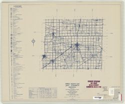
Topical Subject: Roads and Geographic Subject: Jay County (Ind.)
Creator:
Indiana. State Highway Commission (1919-1953)
Publisher:
Indiana. State Highway Commission (1919-1953)
Date Created:
1949
Identifier:
VAC3073-M-00871
Genre:
Road maps
Geographic Location:
Coordinates: W0851300 W0844800 N0403400 N0401900
Related URL:
Catalog URL: https://iucat.iu.edu/catalog/5706369
Abstract:
Blueline. "State roads revised to January 1, 1949." "1942." "Data obtained from State-wide Highway Planning Agency." Includes l...
Call Number:
G4093 .J4P2 1949 .I53
Caption:
Imprint: [Indianapolis?] : State Highway Commission of Indiana, 1949.
Topical Subject: Roads and Geographic Subject: Adams County (Ind.)
Creator:
Indiana. State Highway Commission (1919-1953)
Publisher:
Indiana. State Highway Commission (1919-1953)
Date Created:
1941
Identifier:
VAC3073-M-00767
Genre:
Road maps
Geographic Location:
Coordinates: W0850400 W0844800 N0405500 N0403400
Related URL:
Catalog URL: https://iucat.iu.edu/catalog/5726499
Abstract:
Blue line print. "Corrected to May 1, 1941." "Data obtained from State-wide Highway Planning Survey." Includes location map and charts &q...