
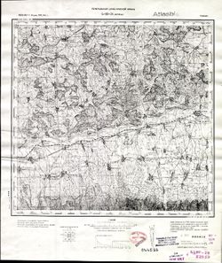
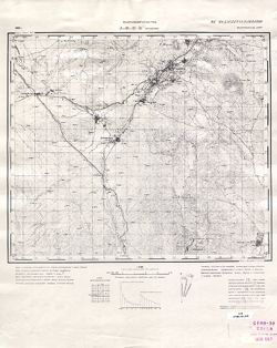
Search Constraints
Search Results
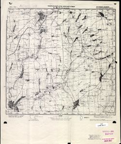
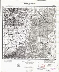
-

- Description:
- 1938
- Subject:
- Topical Subject: Soviet Union, Geographic Subject: Menyusha, and Topical Subject: Maps
- Publisher:
- Главное управление геодезии и картографии при СНК СССР
- Language:
- Russian
- Date Created:
- 1940
- Identifier:
- VAC9619-002141
- Genre:
- Topographic Maps and Military Maps
- Geographic Location:
- Coordinates: 58.3333, 30.5, 58.6667, 31
- Related URL:
- Download GeoTIFF: https://drive.google.com/open?id=1rAh5vxs28ciqg8ypvRJQ83miA2yO8NTU and Catalog URL: https://iucat.iu.edu/catalog/5020129
- Abstract:
- Modern area represented: Менюша (Menyusha), Novgorodskaya oblast, Russia
- Call Number:
- G7000 s100 .S7 sheet O-36-50
- Caption:
- Captured map and Для служебного пользования
- City:
- Менюши (Menyushi)
- Copyright Holder:
- No Copyright - United States
- Country:
- СССР (USSR)
- State/Province:
- Ленинградская область (Leningrad oblast), Новгородский район (Novgorod district), РСФСР (RSFSR), Батецкий район (Batetsky district), and Шимский район (Shims...
- Physical Description:
- Scale: 1:100,000
- Persistent URL:
- http://purl.dlib.indiana.edu/iudl/images/VAC9619/VAC9619-002141
- Provenance:
- DMA Topographic Center, Army Map Service Library, Library of Congress G & M Division
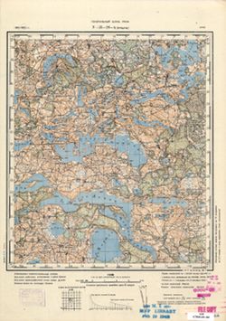
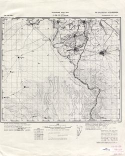
-
- Description:
- 1937
- Subject:
- Topical Subject: Soviet Union, Geographic Subject: Velegoshchi, and Topical Subject: Maps
- Publisher:
- Главное управление геодезии и картографии при СНК СССР
- Language:
- Russian
- Date Created:
- 1940
- Identifier:
- VAC9619-002136
- Genre:
- Military Maps and Topographic Maps
- Geographic Location:
- Coordinates: 58.6667, 30.5, 59, 31
- Related URL:
- Catalog URL: https://iucat.iu.edu/catalog/5020129 and Download GeoTIFF: https://drive.google.com/open?id=1EQVBYooR8iNdVHlbxUmXDKeDL4lmCEDv
- Abstract:
- Modern area represented: Велегощи (Velegoshchi), Novgorodskaya oblast, Russia
- Call Number:
- G7000 s100 .S7 sheet O-36-38
- Caption:
- Captured map and Для служебного пользования
- City:
- Велегощи (Velegoshchi)
- Copyright Holder:
- No Copyright - United States
- Country:
- СССР (USSR)
- State/Province:
- Новгородский район (Novgorod district), Оредежский район (Oredezhsky district), Батецкий район (Batetsky district), РСФСР (RSFSR), and Ленинградская область ...
- Physical Description:
- Scale: 1:100,000
- Persistent URL:
- http://purl.dlib.indiana.edu/iudl/images/VAC9619/VAC9619-002136
- Provenance:
- DMA Topographic Center, Army Map Service Library, OMAHA, Library of Congress Geography & Map Division
-
- Description:
- 1925
- Subject:
- Topical Subject: Maps, Geographic Subject: Mykolayivka, and Topical Subject: Soviet Union
- Publisher:
- Генеральный штаб Красной Армии
- Language:
- Russian
- Date Created:
- 1940
- Identifier:
- VAC9619-001822
- Genre:
- Topographic Maps and Military Maps
- Geographic Location:
- Coordinates: 47.6667, 34, 48, 34.5
- Related URL:
- Download GeoTIFF: https://drive.google.com/open?id=1U6J1cZ3jBto4nQW05mxJrvbDFQrg0G8o and Catalog URL: https://iucat.iu.edu/catalog/5020129
- Abstract:
- Modern area represented: Mykolayivka, Dnipropetrovsk oblast, Ukraine
- Call Number:
- G7000 s100 .S7 sheet L-36-9
- Caption:
- Для служебного пользования
- City:
- Ново-Николаевка (Novo-Nikolayevka)
- Copyright Holder:
- No Copyright - United States
- Country:
- СССР (USSR)
- State/Province:
- Украинская ССР (Ukrainian Soviet Socialist Republic) and Днепропетровская область (Dnipropetrovsk oblast)
- Physical Description:
- Scale: 1:100,000
- Persistent URL:
- http://purl.dlib.indiana.edu/iudl/images/VAC9619/VAC9619-001822
- Provenance:
- CIA Map Library, Atlasblatt
-
- Description:
- 1893
- Subject:
- Topical Subject: Maps, Topical Subject: Soviet Union, and Geographic Subject: Budeşti
- Publisher:
- Генеральный штаб Красной Армии
- Language:
- Russian
- Date Created:
- 1940
- Identifier:
- VAC9619-001809
- Genre:
- Military Maps and Topographic Maps
- Geographic Location:
- Coordinates: 44, 26, 44.3333, 26.5
- Related URL:
- Catalog URL: https://iucat.iu.edu/catalog/5020129 and Download GeoTIFF: https://drive.google.com/open?id=1tDXhb1hBuYrOkSbvJmeKh7J1IEkm384b
- Abstract:
- Modern area represented: Budeşti, Giurgiu county, Romania
- Call Number:
- G7000 s100 .S7 sheet L-35-137
- City:
- Будешти (Budeşti)
- Copyright Holder:
- No Copyright - United States
- Country:
- Румыния (Romania) and Болгария (Bulgaria)
- Physical Description:
- Scale: 1:100,000
- Persistent URL:
- http://purl.dlib.indiana.edu/iudl/images/VAC9619/VAC9619-001809
- Provenance:
- DMA Topographic Center, Army Map Service Library, Library of Congress Geography & Map Division
-
- Description:
- 1883
- Subject:
- Topical Subject: Maps, Geographic Subject: Drăgăneşti-Vlaşca, and Topical Subject: Soviet Union
- Publisher:
- Генеральный штаб Красной Армии
- Language:
- Russian
- Date Created:
- 1940
- Identifier:
- VAC9619-001808
- Genre:
- Topographic Maps and Military Maps
- Geographic Location:
- Coordinates: 44, 25.5, 44.3333, 26
- Related URL:
- Download GeoTIFF: https://drive.google.com/open?id=1kk3WO5ndJeaX7rwmkETltz7GczrbyMJb and Catalog URL: https://iucat.iu.edu/catalog/5020129
- Abstract:
- Modern area represented: Drăgăneşti-Vlaşca, Giurgiu county, Romania
- Call Number:
- G7000 s100 .S7 sheet L-35-136
- City:
- Дрэгэнешти (Drăgăneşti)
- Copyright Holder:
- No Copyright - United States
- Country:
- Румыния (Romania)
- Physical Description:
- Scale: 1:100,000
- Persistent URL:
- http://purl.dlib.indiana.edu/iudl/images/VAC9619/VAC9619-001808
- Provenance:
- DMA Topographic Center, Army Map Service Library, Library of Congress Geography & Map Division
-
- Description:
- 1905
- Subject:
- Topical Subject: Soviet Union, Topical Subject: Maps, and Geographic Subject: Roșiorii de Vede
- Publisher:
- Генеральный штаб РККА
- Language:
- Russian
- Date Created:
- 1940
- Identifier:
- VAC9619-001805
- Genre:
- Topographic Maps and Military Maps
- Geographic Location:
- Coordinates: 44, 24.5, 44.3333, 25
- Related URL:
- Catalog URL: https://iucat.iu.edu/catalog/5020129 and Download GeoTIFF: https://drive.google.com/open?id=1FL58q-DJnIMTpAZZgJSsyZUt5SSzmh7X
- Abstract:
- Modern area represented: Roșiorii de Vede, Teleorman county, Romania
- Call Number:
- G7000 s100 .S7 sheet L-35-134
- City:
- Рошиори - Де Веде (Roșiorii de Vede)
- Copyright Holder:
- No Copyright - United States
- Country:
- Румыния (Romania)
- Physical Description:
- Scale: 1:100,000
- Persistent URL:
- http://purl.dlib.indiana.edu/iudl/images/VAC9619/VAC9619-001805
- Provenance:
- DMA Topographic Center, Army Map Service Library, Library of Congress Geography & Map Division
-
- Description:
- 1893
- Subject:
- Topical Subject: Maps, Topical Subject: Soviet Union, Geographic Subject: Kuibyshivs'kyi district, and Geographic Subject: Donetsk
- Publisher:
- Генеральный штаб Красной Армии
- Language:
- Russian
- Date Created:
- 1940
- Identifier:
- VAC9619-001990
- Genre:
- Topographic Maps and Military Maps
- Geographic Location:
- Coordinates: 47.6667, 37.5, 48, 38
- Related URL:
- Catalog URL: https://iucat.iu.edu/catalog/5020129 and Download GeoTIFF: https://drive.google.com/open?id=1A-5kl08Fmj97FOj3_cwBOc3JNpHC0Hcd
- Abstract:
- Modern area represented: Куйбышевский район (Kuibyshivs'kyi district), Donetsk, Ukraine
- Call Number:
- G7000 s100 .S7 sheet L-37-4
- Caption:
- Для cлужебного пользования
- City:
- Сталино (Stalino)
- Copyright Holder:
- No Copyright - United States
- Country:
- СССР (USSR)
- State/Province:
- Украинская ССР (Ukrainian Soviet Socialist Republic) and Сталинская область (Stalino oblast)
- Physical Description:
- Scale: 1:100,000
- Persistent URL:
- http://purl.dlib.indiana.edu/iudl/images/VAC9619/VAC9619-001990
- Provenance:
- DMA Topographic Center
-
- Description:
- 1891
- Subject:
- Topical Subject: Soviet Union, Topical Subject: Maps, and Geographic Subject: Bucharest
- Publisher:
- Генеральный штаб Красной Армии
- Language:
- Russian
- Date Created:
- 1940
- Identifier:
- VAC9619-001794
- Genre:
- Military Maps and Topographic Maps
- Geographic Location:
- Coordinates: 44.3333, 26, 44.6667, 26.5
- Related URL:
- Catalog URL: https://iucat.iu.edu/catalog/5020129 and Download GeoTIFF: https://drive.google.com/open?id=1Qp3MYlVquPkot6GrpfLeHpxTWY4p62PS
- Abstract:
- Modern area represented: Bucharest, Bucureşti county, Romania
- Call Number:
- G7000 s100 .S7 sheet L-35-125
- City:
- Бухарест (Bucharest)
- Copyright Holder:
- No Copyright - United States
- Country:
- Румыния (Romania)
- Physical Description:
- Scale: 1:100,000
- Persistent URL:
- http://purl.dlib.indiana.edu/iudl/images/VAC9619/VAC9619-001794
- Provenance:
- DMA Topographic Center, Army Map Service Library, OMAHA, Library of Congress Geography & Map Division
-
- Description:
- 1894
- Subject:
- Topical Subject: Maps, Geographic Subject: Tătaru, and Topical Subject: Soviet Union
- Publisher:
- Генеральный штаб Красной Армии
- Language:
- Russian
- Date Created:
- 1940
- Identifier:
- VAC9619-001756
- Genre:
- Military Maps and Topographic Maps
- Geographic Location:
- Coordinates: 44.6667, 27, 45, 27.5
- Related URL:
- Catalog URL: https://iucat.iu.edu/catalog/5020129 and Download GeoTIFF: https://drive.google.com/open?id=12-p_BHuRv8fuQGL5nfUTZsaVfPTWOkwj
- Abstract:
- Modern area represented: Tătaru, Brăila county, Romania
- Call Number:
- G7000 s100 .S7 sheet L-35-115
- City:
- Татару (Tătaru)
- Copyright Holder:
- No Copyright - United States
- Country:
- Румыния (Romania)
- Physical Description:
- Scale: 1:100,000
- Persistent URL:
- http://purl.dlib.indiana.edu/iudl/images/VAC9619/VAC9619-001756
- Provenance:
- DMA Topographic Center, Army Map Service Library, Library of Congress Geography & Map Division
-
- Description:
- 1891
- Subject:
- Topical Subject: Soviet Union, Topical Subject: Maps, and Geographic Subject: Dragomireşti
- Publisher:
- Генеральный штаб Красной Армии
- Language:
- Russian
- Date Created:
- 1940
- Identifier:
- VAC9619-001755
- Genre:
- Military Maps and Topographic Maps
- Geographic Location:
- Coordinates: 46.3333, 27, 46.6667, 27.5
- Related URL:
- Download GeoTIFF: https://drive.google.com/file/d/1hCPO_hgwRlOoKYWPQdYYSitq_p-y_Ezx/view?usp=sharing and Catalog URL: https://iucat.iu.edu/catalog/5020129
- Abstract:
- Modern area represented: Dragomireşti, Vaslui county, Romania
- Call Number:
- G7000 s100 .S7 sheet L-35-55
- City:
- Драгомирешти (Dragomireşti)
- Copyright Holder:
- No Copyright - United States
- Country:
- Румыния (Romania)
- Physical Description:
- Scale: 1:100,000
- Persistent URL:
- http://purl.dlib.indiana.edu/iudl/images/VAC9619/VAC9619-001755
- Provenance:
- CIA Map Library
-
- Description:
- 1891
- Subject:
- Topical Subject: Soviet Union, Topical Subject: Maps, and Geographic Subject: Ploieşti
- Publisher:
- Генеральный штаб Красной Армии
- Language:
- Russian
- Date Created:
- 1940
- Identifier:
- VAC9619-001710
- Genre:
- Military Maps and Topographic Maps
- Geographic Location:
- Coordinates: 44.6667, 26, 45, 26.5
- Related URL:
- Catalog URL: https://iucat.iu.edu/catalog/5020129 and Download GeoTIFF: https://drive.google.com/open?id=1kbO5Fn1_gAfzsDWVCBnsh83RvgIf2cLC
- Abstract:
- Modern area represented: Ploieşti, Prahova county, Romania
- Call Number:
- G7000 s100 .S7 sheet L-35-113
- City:
- Плоешти (Ploieşti)
- Copyright Holder:
- No Copyright - United States
- Country:
- Румыния (Romania)
- Physical Description:
- Scale: 1:100,000
- Persistent URL:
- http://purl.dlib.indiana.edu/iudl/images/VAC9619/VAC9619-001710
- Provenance:
- DMA Topographic Center, Army Map Service Library, Library of Congress Geography & Map Division
-

- Description:
- 1896
- Subject:
- Topical Subject: Soviet Union, Topical Subject: Maps, and Geographic Subject: Târgovişte
- Publisher:
- Генеральный штаб РККА
- Language:
- Russian
- Date Created:
- 1940
- Identifier:
- VAC9619-001699
- Genre:
- Military Maps and Topographic Maps
- Geographic Location:
- Coordinates: 44.6667, 25, 45, 25.5
- Related URL:
- Catalog URL: https://iucat.iu.edu/catalog/5020129 and Download GeoTIFF: https://drive.google.com/open?id=1gMse-lAECHRdjGB57_UtvfIaN-GdoIs9
- Abstract:
- Modern area represented: Târgovişte, Dâmboviţa county, Romania
- Call Number:
- G7000 s100 .S7 sheet L-35-111
- City:
- Тырговиште (Târgovişte)
- Copyright Holder:
- No Copyright - United States
- Country:
- Румыния (Romania)
- Physical Description:
- Scale: 1:100,000
- Persistent URL:
- http://purl.dlib.indiana.edu/iudl/images/VAC9619/VAC9619-001699
- Provenance:
- DMA Topographic Center, Army Map Service Library, OMAHA, Atlasblatt, Library of Congress Geography & Map Division
-
- Description:
- 1900
- Subject:
- Geographic Subject: Piteşti, Topical Subject: Soviet Union, and Topical Subject: Maps
- Publisher:
- Генеральный штаб РККА
- Language:
- Russian
- Date Created:
- 1940
- Identifier:
- VAC9619-001691
- Genre:
- Military Maps and Topographic Maps
- Geographic Location:
- Coordinates: 44.6667, 24.5, 45, 25
- Related URL:
- Catalog URL: https://iucat.iu.edu/catalog/5020129 and Download GeoTIFF: https://drive.google.com/open?id=1p0QpTmFIG_U0Hb_evN49aBe5qjLuUXm5
- Abstract:
- Modern area represented: Piteşti, Argeş county, Romania
- Call Number:
- G7000 s100 .S7 sheet L-35-110
- City:
- Питешти (Piteşti)
- Copyright Holder:
- No Copyright - United States
- Country:
- Румыния (Romania)
- Physical Description:
- Scale: 1:100,000
- Persistent URL:
- http://purl.dlib.indiana.edu/iudl/images/VAC9619/VAC9619-001691
- Provenance:
- DMA Topographic Center, Army Map Service Library, Library of Congress Geography & Map Division, Atlasblatt
-

- Description:
- 1900
- Subject:
- Topical Subject: Soviet Union, Topical Subject: Maps, and Geographic Subject: Curtea de Argeş
- Publisher:
- Генеральный штаб Красной Армии
- Language:
- Russian
- Date Created:
- 1940
- Identifier:
- VAC9619-001686
- Genre:
- Topographic Maps and Military Maps
- Geographic Location:
- Coordinates: 45, 24.5, 45.3333, 25
- Related URL:
- Catalog URL: https://iucat.iu.edu/catalog/5020129 and Download GeoTIFF: https://drive.google.com/open?id=1xKHUf8r5kzgNfr-nYXFiSmBdlkvyDwU8
- Abstract:
- Modern area represented: Curtea de Argeş, Argeș county, Romania
- Call Number:
- G7000 s100 .S7 sheet L-35-98
- City:
- Куртя де Арджеш (Curtea de Argeş)
- Copyright Holder:
- No Copyright - United States
- Country:
- Румыния (Romania)
- Physical Description:
- Scale: 1:100,000
- Persistent URL:
- http://purl.dlib.indiana.edu/iudl/images/VAC9619/VAC9619-001686
- Provenance:
- DMA Topographic Center, Army Map Service Library, OMAHA, Atlasblatt, Library of Congress Geography & Map Division
-
- Description:
- 1889
- Subject:
- Topical Subject: Maps, Topical Subject: Soviet Union, and Geographic Subject: Şercaia
- Publisher:
- Генеральный штаб Красной Армии
- Language:
- Russian
- Date Created:
- 1940
- Identifier:
- VAC9619-001664
- Genre:
- Topographic Maps and Military Maps
- Geographic Location:
- Coordinates: 45.6667, 25, 46, 25.5
- Related URL:
- Download GeoTIFF: https://drive.google.com/open?id=15sEsGkhtdVQiriI3v_WnvLBxHlw8Fmf4 and Catalog URL: https://iucat.iu.edu/catalog/5020129
- Abstract:
- Modern area represented: Şercaia, Brașov county, Romania
- Call Number:
- G7000 s100 .S7 sheet L-35-75
- City:
- Шеркая (Şercaia)
- Copyright Holder:
- No Copyright - United States
- Country:
- Румыния (Romania)
- Physical Description:
- Scale: 1:100,000
- Persistent URL:
- http://purl.dlib.indiana.edu/iudl/images/VAC9619/VAC9619-001664
- Provenance:
- CIA Map Library, Library of Congress Geography & Map Division
-
- Description:
- 1889
- Subject:
- Topical Subject: Soviet Union, Geographic Subject: Făgăraș, and Topical Subject: Maps
- Publisher:
- Генеральный штаб Красной Армии
- Language:
- Russian
- Date Created:
- 1940
- Identifier:
- VAC9619-001652
- Genre:
- Military Maps and Topographic Maps
- Geographic Location:
- Coordinates: 45.6667, 24.5, 46, 25
- Related URL:
- Catalog URL: https://iucat.iu.edu/catalog/5020129 and Download GeoTIFF: https://drive.google.com/open?id=1r58aE53jzC1uEcMtXoMsOM5HyoZ_rRZJ
- Abstract:
- Modern area represented: Făgăraș, Brașov county, Romania
- Call Number:
- G7000 s100 .S7 sheet L-35-74
- City:
- Фэгэраш (Făgăraș)
- Copyright Holder:
- No Copyright - United States
- Country:
- Румыния (Romania)
- Physical Description:
- Scale: 1:100,000
- Persistent URL:
- http://purl.dlib.indiana.edu/iudl/images/VAC9619/VAC9619-001652
- Provenance:
- CIA Map Library, Atlasblatt, Library of Congress Geography & Map Division
-

- Description:
- 1900
- Subject:
- Topical Subject: Maps, Geographic Subject: Deva, and Topical Subject: Soviet Union
- Publisher:
- Генеральный штаб Красной Армии
- Language:
- Russian
- Date Created:
- 1940
- Identifier:
- VAC9619-001255
- Genre:
- Topographic Maps and Military Maps
- Geographic Location:
- Coordinates: 45.6667, 22.5, 46, 23
- Related URL:
- Download GeoTIFF: https://drive.google.com/open?id=15eZ-SSDrKDZRKb7EoGa8LOVMH1kY1aG8 and Catalog URL: https://iucat.iu.edu/catalog/5020129
- Abstract:
- Modern area represented: Deva, Hunedoara county, Romania
- Call Number:
- G7000 s100 .S7 sheet L-34-82
- City:
- Дева (Deva)
- Copyright Holder:
- No Copyright - United States
- Country:
- Румыния (Romania)
- Physical Description:
- Scale: 1:100,000
- Persistent URL:
- http://purl.dlib.indiana.edu/iudl/images/VAC9619/VAC9619-001255
- Provenance:
- DMA Topographic Center, Army Map Service Library, Library of Congress Geography & Map Division
-

- Description:
- 1906
- Subject:
- Topical Subject: Maps and Topical Subject: Soviet Union
- Publisher:
- Генеральный штаб РККА
- Language:
- Russian
- Date Created:
- 1940
- Identifier:
- VAC9619-000854
- Genre:
- Military Maps and Topographic Maps
- Related URL:
- Catalog URL: https://iucat.iu.edu/catalog/5020129
- Call Number:
- G7000 s100 .S7 sheet K-52-31
- City:
- Ст. Чатяогоу
- Copyright Holder:
- No Copyright - United States
- Physical Description:
- Scale: 1:100,000
- Persistent URL:
- http://purl.dlib.indiana.edu/iudl/images/VAC9619/VAC9619-000854
- Provenance:
- DMA Topographic Center, Army Map Service Library, Library of Congress Geography & Map Division, Atlasblatt
-
- Subject:
- Topical Subject: Soviet Union, Geographic Subject: Mindūnai, and Topical Subject: Maps
- Publisher:
- Генеральный штаб РККА
- Language:
- Russian
- Date Created:
- 1940
- Identifier:
- VAC9619-000488
- Genre:
- Military Maps and Topographic Maps
- Geographic Location:
- Coordinates: 55.1667, 25.5, 55.3333, 25.75
- Related URL:
- Download GeoTIFF: https://drive.google.com/open?id=1kDE-5GDrUKtZW5X101YXnY1Xw8yYVNCW and Catalog URL: http://iucat.iu.edu/catalog/5020131
- Abstract:
- Modern area represented: Mindūnai, Lithuania
- Call Number:
- G7000 s50 .S68 sheet N-35-28-A
- City:
- Мундуны (Munduny)
- Copyright Holder:
- No Copyright - United States
- Country:
- Литва (Lithuania)
- Physical Description:
- Scale: 1:50,000
- Persistent URL:
- http://purl.dlib.indiana.edu/iudl/images/VAC9619/VAC9619-000488
- Provenance:
- M. I. Map Library, Justus Perthes Kartensammlung, GS, RA, G000-30
-
- Subject:
- Topical Subject: Maps, Topical Subject: Soviet Union, and Geographic Subject: Julfa
- Publisher:
- Генеральный штаб Красной Армии
- Language:
- Russian
- Date Created:
- 1940
- Identifier:
- VAC9619-000089
- Genre:
- Topographic Maps and Military Maps
- Geographic Location:
- Coordinates: 38.8333, 45.5, 39, 45.75
- Related URL:
- Download GeoTIFF: https://drive.google.com/open?id=1fZhMoeilfY5E-PsoYnAeUMHJQW6GUmXx and Catalog URL: http://iucat.iu.edu/catalog/5020131
- Abstract:
- Modern area represented: Julfa, Azerbaijan
- Call Number:
- G7000 s50 .S68 sheet J-38-44-A
- Caption:
- Не подлежит оглашению
- City:
- Джульфа (Dzhulfa)
- Copyright Holder:
- No Copyright - United States
- Country:
- Иран (Iran) and СССР (USSR)
- State/Province:
- Нахичеванская АССР (Nakhichevan Autonomous Soviet Socialist Republic)
- Physical Description:
- Scale: 1:50,000
- Persistent URL:
- http://purl.dlib.indiana.edu/iudl/images/VAC9619/VAC9619-000089
- Provenance:
- CIA Map Library
-
- Description:
- 1912
- Subject:
- Topical Subject: Soviet Union and Topical Subject: Maps
- Publisher:
- Генеральный штаб РККА
- Language:
- Russian
- Date Created:
- 1940
- Identifier:
- VAC9619-000088
- Genre:
- Military Maps and Topographic Maps
- Geographic Location:
- Coordinates: 38.8333, 45.25, 39, 45.5
- Related URL:
- Catalog URL: http://iucat.iu.edu/catalog/5020131 and Download GeoTIFF: https://drive.google.com/open?id=1Oy-smGi4yZi1PkUg9SECDFKap9ehGyxn
- Call Number:
- G7000 s50 .S68 sheet J-38-39-B
- Caption:
- Не подлежит оглашению
- City:
- Гюльферадж (Gyulferadzh)
- Copyright Holder:
- No Copyright - United States
- Country:
- СССР (USSR) and Иран (Iran)
- State/Province:
- Нахичеванская АССР (Nakhichevan Autonomous Soviet Socialist Republic)
- Physical Description:
- Scale: 1:50,000
- Persistent URL:
- http://purl.dlib.indiana.edu/iudl/images/VAC9619/VAC9619-000088
-
- Description:
- 1939
- Subject:
- Geographic Subject: Əbrəqunus, Topical Subject: Soviet Union, and Topical Subject: Maps
- Publisher:
- Генеральный штаб РККА
- Language:
- Russian
- Date Created:
- 1940
- Identifier:
- VAC9619-000079
- Genre:
- Military Maps and Topographic Maps
- Geographic Location:
- Coordinates: 39, 45.5, 39.1667, 45.75
- Related URL:
- Download GeoTIFF: https://drive.google.com/open?id=1998swVPJ9QtnYo-IMWGIfroqvaOTFJb9 and Catalog URL: http://iucat.iu.edu/catalog/5020131
- Abstract:
- Modern area represented: Əbrəqunus, Azerbaijan
- Call Number:
- G7000 s50 .S68 sheet J-38-32-C
- Caption:
- Не подлежит оглашению
- City:
- Абракунис
- Copyright Holder:
- No Copyright - United States
- Country:
- СССР (USSR)
- State/Province:
- Нахичеванская АССР (Nakhichevan Autonomous Soviet Socialist Republic)
- Physical Description:
- Scale: 1:50,000
- Persistent URL:
- http://purl.dlib.indiana.edu/iudl/images/VAC9619/VAC9619-000079
- Provenance:
- CIA Map Library
-
- Subject:
- Geographic Subject: Nehrəm, Topical Subject: Maps, and Topical Subject: Soviet Union
- Publisher:
- Генеральный штаб РККА
- Language:
- Russian
- Date Created:
- 1940
- Identifier:
- VAC9619-000076
- Genre:
- Military Maps and Topographic Maps
- Geographic Location:
- Coordinates: 39, 45.25, 39.1667, 45.5
- Related URL:
- Download GeoTIFF: https://drive.google.com/open?id=1mM1VIpCbqqPPt0FAbm9talybksIlvehj and Catalog URL: http://iucat.iu.edu/catalog/5020131
- Abstract:
- Modern area represented: Nehrəm, Azerbaijan
- Call Number:
- G7000 s50 .S68 sheet J-38-31-D
- Caption:
- Не подлежит оглашению
- City:
- Неграм (Negram)
- Copyright Holder:
- No Copyright - United States
- Country:
- Иран (Iran) and СССР (USSR)
- State/Province:
- Нахичеванская АССР (Nakhichevan Autonomous Soviet Socialist Republic)
- Physical Description:
- Scale: 1:50,000
- Persistent URL:
- http://purl.dlib.indiana.edu/iudl/images/VAC9619/VAC9619-000076
- Provenance:
- CIA Map Library
-
- Description:
- 1939
- Subject:
- Topical Subject: Maps, Geographic Subject: Naxçıvan, and Topical Subject: Soviet Union
- Publisher:
- Генеральный штаб РККА
- Language:
- Russian
- Date Created:
- 1940
- Identifier:
- VAC9619-000075
- Genre:
- Topographic Maps and Military Maps
- Geographic Location:
- Coordinates: 39.1667, 45.25, 39.3333, 45.5
- Related URL:
- Download GeoTIFF: https://drive.google.com/open?id=1WFbUP-xCIugjZ6sjO9PseZPZVj0V0Bno and Catalog URL: http://iucat.iu.edu/catalog/5020131
- Abstract:
- Modern area represented: Naxçıvan, Azerbaijan
- Call Number:
- G7000 s50 .S68 sheet J-38-31-B
- Caption:
- Не подлежит оглашению
- City:
- Нахичевань (Nakhichevan')
- Copyright Holder:
- No Copyright - United States
- Country:
- СССР (USSR) and Иран (Iran)
- State/Province:
- Нахичеванская АССР (Nakhichevan Autonomous Soviet Socialist Republic)
- Physical Description:
- Scale: 1:50,000
- Persistent URL:
- http://purl.dlib.indiana.edu/iudl/images/VAC9619/VAC9619-000075
- Provenance:
- CIA Map Library
-
![Indiana Porter quadrangle [1940 printing]](https://iiif.uits.iu.edu/iiif/2/000013119%2Ffiles%2F0b2153bf-bc62-414d-8775-578073b39f68/full/250,/0/default.jpg)
- Subject:
- Geographic Subject: Lake County (Ind.) and Geographic Subject: Porter County (Ind.)
- Creator:
- Geological Survey (U.S.) and Clement, S. E. (Stephen Earl), 1894-1981
- Publisher:
- Geological Survey (U.S.)
- Date Created:
- 1940
- Identifier:
- VAC3073-M-01379
- Genre:
- Topographic maps, Quadrangle maps, and 15 minute topographic maps
- Geographic Location:
- Coordinates: W0871500 W0870000 N0414500 N0413000
- Related URL:
- Catalog URL: https://iucat.iu.edu/catalog/18416370
- Abstract:
- Filing title: Porter, Ind. Edition of 1940. Polyconic projection. Relief shown by contours and spot heights. Contour interval 10 feet. Surveyed in 1934. Repr...
- Call Number:
- G4090 s62 .G4 Porter 1940
- Caption:
- Imprint: Washington, D.C. : U.S. Dept. of the Interior, Geological Survey, 1940
- Physical Description:
- Scale: 1:62,500 and Dimensions: 45 x 42 cm or smaller
- Alternate Identifier:
- Title Control Number: a18416370
- Persistent URL:
- https://purl.dlib.indiana.edu/iudl/images/VAC3073/VAC3073-M-01379
- Provenance:
- Part of Geological Survey (U.S.). Indiana 1:62,500.
-
![Indiana Porter quadrangle [1940 printing]](https://iiif.uits.iu.edu/iiif/2/qb98nk032%2Ffiles%2F56b05fe7-af3d-4253-a42a-a53971fe7601/full/250,/0/default.jpg)
- Subject:
- Geographic Subject: Porter County (Ind.) and Geographic Subject: Lake County (Ind.)
- Creator:
- Clement, S. E. (Stephen Earl), 1894-1981 and Geological Survey (U.S.)
- Publisher:
- Geological Survey (U.S.)
- Date Created:
- 1940
- Identifier:
- VAC3073-M-01299
- Genre:
- 15 minute topographic maps, Quadrangle maps, and Topographic maps
- Geographic Location:
- Coordinates: W0871500 W0870000 N0414500 N0413000
- Related URL:
- Catalog URL: https://iucat.iu.edu/catalog/18416370
- Abstract:
- Filing title: Porter, Ind. Edition of 1940. Polyconic projection. Relief shown by contours and spot heights. Contour interval 10 feet. Surveyed in 1934. Repr...
- Call Number:
- G4090 s62 .G4 Porter 1940
- Caption:
- Imprint: Washington, D.C. : U.S. Dept. of the Interior, Geological Survey, 1940
- Physical Description:
- Scale: 1:62,500 and Dimensions: 45 x 42 cm or smaller
- Alternate Identifier:
- Title Control Number: a18416370
- Persistent URL:
- https://purl.dlib.indiana.edu/iudl/images/VAC3073/VAC3073-M-01299
- Provenance:
- Part of Geological Survey (U.S.). Indiana 1:62,500.
-
![Posey County [Indiana] land use map : preliminary](https://iiif.uits.iu.edu/iiif/2/z603s182f%2Ffiles%2F435d231e-86e7-4295-89a3-c11ee3702fdf/full/250,/0/default.jpg)
- Subject:
- Topical Subject: Land use and Geographic Subject: Posey County (Ind.)
- Creator:
- Posey County (Ind.). Land Use Planning Committee
- Publisher:
- Posey County (Ind.). Land Use Planning Committee
- Date Created:
- 1940
- Identifier:
- VAC3073-M-00997
- Genre:
- Thematic maps
- Geographic Location:
- Coordinates: W0880552 W0874117 N0381349 N0374618
- Related URL:
- Catalog URL: https://iucat.iu.edu/catalog/5126520
- Abstract:
- Includes chart showing type of land use, acreage, and recommended use.
- Call Number:
- G4093.P6G4 1940 .P67
- Caption:
- Imprint: [Mount Vernon, Ind.?] : The Committee, [1940?]
- Physical Description:
- Scale: Scale not given. and Dimensions: 28 x 19 cm, on sheet 39 x 28 cm
- Alternate Identifier:
- Title Control Number: a5126520
- Persistent URL:
- https://purl.dlib.indiana.edu/iudl/images/VAC3073/VAC3073-M-00997
-
![Vigo County [Indiana] land use map: preliminary](https://iiif.uits.iu.edu/iiif/2/gq67kv03f%2Ffiles%2Fbc5313f9-e338-4b17-a48d-60e4496abc8a/full/250,/0/default.jpg)
- Subject:
- Geographic Subject: Vigo County (Ind.) and Topical Subject: Land use
- Creator:
- Vigo County (Ind.). Land Use Planning Committee
- Publisher:
- Vigo County (Ind.). Land Use Planning Committee
- Date Created:
- 1940
- Identifier:
- VAC3073-M-00953
- Genre:
- Thematic maps
- Geographic Location:
- Coordinates: W0873716 W0871156 N0393629 N0391532
- Related URL:
- Catalog URL: https://iucat.iu.edu/catalog/5126635
- Abstract:
- Includes chart showing type of land use, acreage, and recommended use.
- Call Number:
- G4093.V5G4 1940 .V54
- Caption:
- Imprint: [Terre Haute, Ind.?] : The Committee, [1940?]
- Physical Description:
- Dimensions: 24 x 21 cm, on sheet 39 x 28 cm and Scale: Scale not given.
- Alternate Identifier:
- Title Control Number: a5126635
- Persistent URL:
- https://purl.dlib.indiana.edu/iudl/images/VAC3073/VAC3073-M-00953
-
![Harrison County [Indiana] land use map : preliminary](https://iiif.uits.iu.edu/iiif/2/fb495d293%2Ffiles%2Fa6215f59-e4a8-4559-b192-18779587518f/full/250,/0/default.jpg)
- Subject:
- Topical Subject: Land use and Geographic Subject: Harrison County (Ind.)
- Creator:
- Harrison County (Ind.). Land Use Planning Committee
- Publisher:
- Harrison County (Ind.). Land Use Planning Committee
- Date Created:
- 1940
- Identifier:
- VAC3073-M-00901
- Genre:
- Thematic maps
- Geographic Location:
- Coordinates: W0861947 W0855402 N0382521 N0375728
- Related URL:
- Catalog URL: https://iucat.iu.edu/catalog/5126325
- Abstract:
- Includes chart showing type of land use, acreage, and recommended use.
- Call Number:
- G4093.H4G4 1940 .H37
- Caption:
- Imprint: [Corydon, Ind.?] : The Committee, [1940?]
- Physical Description:
- Scale: Scale not given. and Dimensions: 28 x 21 cm, on sheet 39 x 28 cm
- Alternate Identifier:
- Title Control Number: a5126325
- Persistent URL:
- https://purl.dlib.indiana.edu/iudl/images/VAC3073/VAC3073-M-00901
-
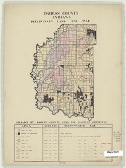
- Subject:
- Geographic Subject: Daviess County (Ind.) and Topical Subject: Land use
- Creator:
- Daviess County (Ind.). Land Use Planning Committee
- Publisher:
- United States. Bureau of Agricultural Economics
- Date Created:
- 1940
- Identifier:
- VAC3073-M-00818
- Genre:
- Thematic maps
- Geographic Location:
- Coordinates: W0871645 W0865414 N0385415 N0382925
- Related URL:
- Catalog URL: https://iucat.iu.edu/catalog/5125899
- Abstract:
- "Color reproduction by Bureau of Agricultural Economics, U.S.D.A." Includes chart showing type of land use, acreage, and recommended use.
- Call Number:
- G4093 .D2G4 1940 .D38
- Caption:
- Imprint: [Washington, D.C.?] : U.S. Bureau of Agricultural Economics, [1940]
- Physical Description:
- Scale: Scale not given. and Dimensions: 23 x 16 cm, on sheet 38 x 28 cm
- Alternate Identifier:
- Title Control Number: a5125899
- Persistent URL:
- https://purl.dlib.indiana.edu/iudl/images/VAC3073/VAC3073-M-00818
-
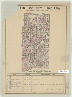
- Subject:
- Geographic Subject: Martin County (Ind.) and Topical Subject: Land use
- Creator:
- Martin County (Ind.). Land Use Planning Committee
- Publisher:
- United States. Bureau of Agricultural Economics
- Date Created:
- 1940
- Identifier:
- VAC3073-M-00782
- Genre:
- Thematic maps
- Geographic Location:
- Coordinates: W0865527 W0864056 N0385416 N0382941
- Related URL:
- Catalog URL: https://iucat.iu.edu/catalog/5126476
- Abstract:
- "Color reproduction by Bureau of Agricultural Economics, U.S.D.A." "8-31-40." Includes chart showing type of land use, acreage, and recom...
- Call Number:
- G4093.M5G4 1940 .M37
- Caption:
- Imprint: [Washington, D.C.?] : U.S. Bureau of Agricultural Economics, [1940]
- Physical Description:
- Scale: Scale not given. and Dimensions: 25 x 12 cm, on sheet 39 x 28 cm
- Alternate Identifier:
- Title Control Number: a5126476
- Persistent URL:
- https://purl.dlib.indiana.edu/iudl/images/VAC3073/VAC3073-M-00782
-
![Clark County [Indiana] land use map](https://iiif.uits.iu.edu/iiif/2/0p097b31w%2Ffiles%2F05b32dea-49f5-4006-84cd-ba5a5f21b5fb/full/250,/0/default.jpg)
- Subject:
- Geographic Subject: Clark County (Ind.) and Topical Subject: Land use
- Creator:
- Clark County (Ind.). Land Use Planning Committee
- Publisher:
- Clark County (Ind.). Land Use Planning Committee
- Date Created:
- 1940
- Identifier:
- VAC3073-M-00765
- Genre:
- Thematic maps
- Geographic Location:
- Coordinates: W0855940 W0852455 N0383624 N0381601
- Related URL:
- Catalog URL: https://iucat.iu.edu/catalog/5125787
- Abstract:
- Includes chart showing type of land use, acreage, and recommended use.
- Call Number:
- G4093.C4G4 1940 C53
- Caption:
- Imprint: [Jeffersonville, Ind.?] : The Committee, [1940?]
- Physical Description:
- Scale: Scale not given. and Dimensions: 26 x 19 cm, on sheet 39 x 28 cm
- Alternate Identifier:
- Title Control Number: a5125787
- Persistent URL:
- https://purl.dlib.indiana.edu/iudl/images/VAC3073/VAC3073-M-00765
-
![Crawford County [Indiana] land use map: preliminary](https://iiif.uits.iu.edu/iiif/2/4x51jm535%2Ffiles%2Fa4e48692-d643-428b-b306-48b4149d9cca/full/250,/0/default.jpg)
- Subject:
- Topical Subject: Land use and Geographic Subject: Crawford County (Ind.)
- Creator:
- Crawford County (Ind.). Land Use Planning Committee
- Publisher:
- Crawford County (Ind.). Land Use Planning Committee
- Date Created:
- 1940
- Identifier:
- VAC3073-M-00755
- Genre:
- Thematic maps
- Geographic Location:
- Coordinates: W0864053 W0861443 N0382522 N0380619
- Related URL:
- Catalog URL: https://iucat.iu.edu/catalog/5125845
- Abstract:
- Includes chart showing type of land use, acreage, and recommended use.
- Call Number:
- G4093.C7G4 1940 .C73
- Caption:
- Imprint: [English, Ind,?] : The Committee, [1940?]
- Physical Description:
- Dimensions: 24 x 25 cm, on sheet 28 x 39 cm and Scale: Scale not given.
- Alternate Identifier:
- Title Control Number: a5125845
- Persistent URL:
- https://purl.dlib.indiana.edu/iudl/images/VAC3073/VAC3073-M-00755
-
![Owen County [Indiana] land use map : preliminary](https://iiif.uits.iu.edu/iiif/2/vm40zt743%2Ffiles%2F4526b850-2c0a-4c70-b6d8-a4d29088e57e/full/250,/0/default.jpg)
- Subject:
- Topical Subject: Land use and Geographic Subject: Owen County (Ind.)
- Creator:
- Owen County (Ind.). Land Use Planning Committee
- Publisher:
- Owen County (Ind.). Land Use Planning Committee
- Date Created:
- 1940
- Identifier:
- VAC3073-M-00753
- Genre:
- Thematic maps
- Geographic Location:
- Coordinates: W0870317 W0863750 N0392824 N0390956
- Related URL:
- Catalog URL: https://iucat.iu.edu/catalog/5126500
- Abstract:
- Includes chart showing type of land use, acreage, and recommended use.
- Call Number:
- G4093.O8G4 1940 O94
- Caption:
- Imprint: [Spencer, Ind.?] : The Committee, [1940?]
- Physical Description:
- Dimensions: 22 x 24 cm, on sheet 39 x 28 cm and Scale: Scale not given.
- Alternate Identifier:
- Title Control Number: a5126500
- Persistent URL:
- https://purl.dlib.indiana.edu/iudl/images/VAC3073/VAC3073-M-00753
-
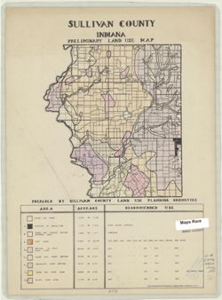
- Subject:
- Topical Subject: Land use and Geographic Subject: Sullivan County (Ind.)
- Creator:
- Sullivan County (Ind.). Land Use Planning Committee
- Publisher:
- United States. Bureau of Agricultural Economics
- Date Created:
- 1940
- Identifier:
- VAC3073-M-00727
- Genre:
- Thematic maps
- Geographic Location:
- Coordinates: W0873931 W0871425 N0391534 N0385405
- Related URL:
- Catalog URL: https://iucat.iu.edu/catalog/5126550
- Abstract:
- "Color reproduction by Bureau of Agricultural Economics, U.S.D.A." Includes chart showing type of land use, acreage, and recommended use.
- Call Number:
- G4093.S8G4 1940 .S85
- Caption:
- Imprint: [Washington, D.C.?] : U.S. Bureau of Agricultural Economics, [1940?]
- Physical Description:
- Dimensions: 21 x 19 cm, on sheet 38 x 28 cm and Scale: Scale not given.
- Alternate Identifier:
- Title Control Number: a5126550
- Persistent URL:
- https://purl.dlib.indiana.edu/iudl/images/VAC3073/VAC3073-M-00727
-
![Pike County [Indiana] land use map : preliminary](https://iiif.uits.iu.edu/iiif/2/rx914s61v%2Ffiles%2Fceecabf2-e7fb-4138-930c-04b192729886/full/250,/0/default.jpg)
- Subject:
- Topical Subject: Land use and Geographic Subject: Pike County (Ind.)
- Creator:
- Pike County (Ind.). Land Use Planning Committee
- Publisher:
- Pike County (Ind.). Land Use Planning Committee
- Date Created:
- 1940
- Identifier:
- VAC3073-M-00686
- Genre:
- Thematic maps
- Geographic Location:
- Coordinates: W0872746 W0870419 N0383308 N0381351
- Related URL:
- Catalog URL: https://iucat.iu.edu/catalog/5126511
- Abstract:
- Includes chart showing type of land use, acreage, and recommended use.
- Call Number:
- G4093.P4G4 1940 .P55
- Caption:
- Imprint: [Petersburg, Ind.?] : The Committee, [1940?]
- Physical Description:
- Scale: Scale not given. and Dimensions: 24 x 23 cm, on sheet 39 x 28 cm
- Alternate Identifier:
- Title Control Number: a5126511
- Persistent URL:
- https://purl.dlib.indiana.edu/iudl/images/VAC3073/VAC3073-M-00686
-
![Switzerland County [Indiana] preliminary land use map](https://iiif.uits.iu.edu/iiif/2/7p88dk86q%2Ffiles%2F702dbc2b-a33d-45c2-9347-ad26de2efd2e/full/250,/0/default.jpg)
- Subject:
- Geographic Subject: Switzerland County (Ind.) and Topical Subject: Land use
- Creator:
- Switzerland County (Ind.). Land Use Planning Committee
- Publisher:
- Switzerland County (Ind.). Land Use Planning Committee
- Date Created:
- 1940
- Identifier:
- VAC3073-M-00661
- Genre:
- Thematic maps
- Geographic Location:
- Coordinates: W0851212 W0844704 N0385546 N0384114
- Related URL:
- Catalog URL: https://iucat.iu.edu/catalog/5126605
- Abstract:
- Includes chart showing type of land use, acreage, and recommended use.
- Call Number:
- G4093.S9 1940 .S95
- Caption:
- Imprint: [Vevay, Ind.?] : The Committee, [1940?]
- Physical Description:
- Dimensions: 21 x 16 cm, on sheet 39 x 28 cm and Scale: Scale not given.
- Alternate Identifier:
- Title Control Number: a5126605
- Persistent URL:
- https://purl.dlib.indiana.edu/iudl/images/VAC3073/VAC3073-M-00661
-
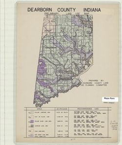
- Subject:
- Geographic Subject: Dearborn County (Ind.) and Topical Subject: Land use
- Creator:
- Dearborn County (Ind.). Land Use Planning Committee
- Publisher:
- Dearborn County (Ind.). Land Use Planning Committee
- Date Created:
- 1940
- Identifier:
- VAC3073-M-00613
- Genre:
- Thematic maps
- Geographic Location:
- Coordinates: W0850757 W0844909 N0391826 N0385607
- Related URL:
- Catalog URL: https://iucat.iu.edu/catalog/5126249
- Abstract:
- Includes chart showing type of land use, acreage, and recommended use.
- Call Number:
- G4093.D3G4 1940 .D43
- Caption:
- Imprint: [Lawrenceburg, Ind.?] : The Committee, [1940?]
- Physical Description:
- Dimensions: 26 x 17 cm, on sheet 39 x 28 cm and Scale: Scale not given.
- Alternate Identifier:
- Title Control Number: a5126249
- Persistent URL:
- https://purl.dlib.indiana.edu/iudl/images/VAC3073/VAC3073-M-00613
-
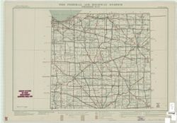
- Subject:
- Geographic Subject: Indiana and Topical Subject: Roads
- Creator:
- United States. Public Roads Administration
- Publisher:
- United States. Public Roads Administration
- Date Created:
- 1940
- Identifier:
- VAC3073-M-00588
- Genre:
- Road maps
- Geographic Location:
- Coordinates: W0880700 W0844500 N0414500 N0375200
- Related URL:
- Catalog URL: https://iucat.iu.edu/catalog/5164306
- Abstract:
- "Base map from U.S. Geological Survey state map." "Data corrected to May 1, 1940."
- Call Number:
- G4091.P2 1940 .U5
- Caption:
- Imprint: [Washington, D.C.?] : The Administration, [1940]
- Physical Description:
- Scale: 1:500,000 and Dimensions: 92 x 70 cm, sheets 55 x 79 cm
- Alternate Identifier:
- Title Control Number: a5164306
- Persistent URL:
- https://purl.dlib.indiana.edu/iudl/images/VAC3073/VAC3073-M-00588
-
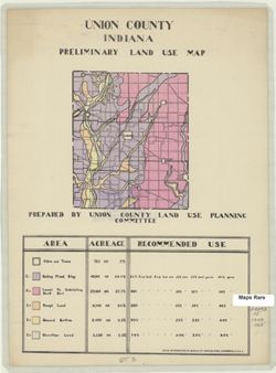
- Subject:
- Geographic Subject: Union County (Ind.) and Topical Subject: Land use
- Creator:
- Union County (Ind.). Land Use Planning Committee
- Publisher:
- United States. Bureau of Agricultural Economics
- Date Created:
- 1940
- Identifier:
- VAC3073-M-00409
- Genre:
- Thematic maps
- Geographic Location:
- Coordinates: W0850210 W0844851 N0394345 N0393119
- Related URL:
- Catalog URL: https://iucat.iu.edu/catalog/5126621
- Abstract:
- "Color reproduction by Bureau of Agricultural Economics, U.S.D.A." Includes chart showing type of land use, acreage, and recommended use.
- Call Number:
- G4093.U5 1940 .U55
- Caption:
- Imprint: [Washington, D.C.?] : U.S. Bureau of Agricultural Economics, [1940?]
- Physical Description:
- Scale: Scale not given. and Dimensions: 15 x 13 cm, on sheet 38 x 28 cm
- Alternate Identifier:
- Title Control Number: a5126621
- Persistent URL:
- https://purl.dlib.indiana.edu/iudl/images/VAC3073/VAC3073-M-00409
-
![Dubois County [Indiana] land use map : preliminary](https://iiif.uits.iu.edu/iiif/2/n583zx450%2Ffiles%2F8319c249-85b5-442f-8ac2-cef230e85e51/full/250,/0/default.jpg)
- Subject:
- Topical Subject: Land use and Geographic Subject: Dubois County (Ind.)
- Creator:
- Dubois County (Ind.). Land Use Planning Committee
- Publisher:
- Dubois County (Ind.). Land Use Planning Committee
- Date Created:
- 1940
- Identifier:
- VAC3073-M-00356
- Genre:
- Thematic maps
- Geographic Location:
- Coordinates: W0870423 W0864044 N0383135 N0381210
- Related URL:
- Catalog URL: https://iucat.iu.edu/catalog/5126254
- Abstract:
- Includes chart showing type of land use, acreage, and recommended use.
- Call Number:
- G4093.D8G4 1940 D83
- Caption:
- Imprint: [Jasper, Ind.?] : The Committee, [1940?]
- Physical Description:
- Dimensions: 22 x 22 cm, on sheet 39 x 28 cm and Scale: Scale not given.
- Alternate Identifier:
- Title Control Number: a5126254
- Persistent URL:
- https://purl.dlib.indiana.edu/iudl/images/VAC3073/VAC3073-M-00356
-
- Subject:
- Topical Subject: National cemeteries and Geographic Subject: Indiana
- Publisher:
- [U.S. War Dept.?]
- Date Created:
- 1940
- Identifier:
- VAC3073-M-00333
- Genre:
- Thematic maps
- Geographic Location:
- Coordinates: W0880700 W0844500 N0414500 N0375200
- Related URL:
- Catalog URL: https://iucat.iu.edu/catalog/5177103
- Abstract:
- Shows proposed National Cemetery in Indianapolis with 25 mile concentric rings showing distance from the proposed National Cemetery and other National Cemete...
- Call Number:
- G4091.G54 1940 .S73
- Caption:
- Imprint: [Washington, D.C.? : U.S. War Dept.?, 194-?]
- Physical Description:
- Dimensions: 64 x 42 cm and Scale: 1:715,000
- Alternate Identifier:
- Title Control Number: a5177103
- Persistent URL:
- https://purl.dlib.indiana.edu/iudl/images/VAC3073/VAC3073-M-00333
-
![Vanderburgh County [Indiana] preliminary land use map](https://iiif.uits.iu.edu/iiif/2/qf85pf475%2Ffiles%2F018f45ab-c6b4-40b1-9e75-dc08e8ae02ae/full/250,/0/default.jpg)
- Subject:
- Geographic Subject: Vanderburgh County (Ind.) and Topical Subject: Land use
- Creator:
- Vanderburgh County (Ind.). Land Use Planning Committee
- Publisher:
- Vanderburgh County (Ind.). Land Use Planning Committee
- Date Created:
- 1940
- Identifier:
- VAC3073-M-00328
- Genre:
- Thematic maps
- Geographic Location:
- Coordinates: W0874202 W0872657 N0381006 N0374932
- Related URL:
- Catalog URL: https://iucat.iu.edu/catalog/5126629
- Abstract:
- Includes chart showing type of land use, acreage, and recommended use.
- Call Number:
- G4093.V3G4 1940 .V36
- Caption:
- Imprint: [Evansville, Ind.?] : The Committee, [1940?]
- Physical Description:
- Scale: Scale not given. and Dimensions: 26 x 14 cm, on sheet 39 x 28 cm
- Alternate Identifier:
- Title Control Number: a5126629
- Persistent URL:
- https://purl.dlib.indiana.edu/iudl/images/VAC3073/VAC3073-M-00328
-
![Putnam County [Indiana] land use map : preliminary](https://iiif.uits.iu.edu/iiif/2/ff3669524%2Ffiles%2Fa99c639f-fb69-43c3-a158-8bffb65d6978/full/250,/0/default.jpg)
- Subject:
- Topical Subject: Land use and Geographic Subject: Putnam County (Ind.)
- Creator:
- Putnam County (Ind.). Land Use Planning Committee
- Publisher:
- Putnam County (Ind.). Land Use Planning Committee
- Date Created:
- 1940
- Identifier:
- VAC3073-M-00324
- Genre:
- Thematic maps
- Geographic Location:
- Coordinates: W0870053 W0863829 N0395200 N0392812
- Related URL:
- Catalog URL: https://iucat.iu.edu/catalog/5126528
- Abstract:
- Includes chart showing type of land use, acreage, and recommended use.
- Call Number:
- G4093.P8G4 1940 .P88
- Caption:
- Imprint: [Greencastle, Ind.?] : The Committee, [1940?]
- Physical Description:
- Dimensions: 23 x 17 cm, on sheet 39 x 28 cm and Scale: Scale not given.
- Alternate Identifier:
- Title Control Number: a5126528
- Persistent URL:
- https://purl.dlib.indiana.edu/iudl/images/VAC3073/VAC3073-M-00324
-
![Jefferson County [Indiana] preliminary land use map](https://iiif.uits.iu.edu/iiif/2/2f75sc94w%2Ffiles%2F7a98897d-f193-46e6-9bdf-a873b1f3fc06/full/250,/0/default.jpg)
- Subject:
- Geographic Subject: Jefferson County (Ind.) and Topical Subject: Land use
- Creator:
- Jefferson County (Ind.). Land Use Planning Committee
- Publisher:
- United States. Bureau of Agricultural Economics
- Date Created:
- 1940
- Identifier:
- VAC3073-M-00300
- Genre:
- Thematic maps
- Geographic Location:
- Coordinates: W0854102 W0851205 N0385450 N0383509
- Related URL:
- Catalog URL: https://iucat.iu.edu/catalog/5126351
- Abstract:
- "Color reproduction by Bureau of Agricultural Economics, U.S.D.A." Includes chart showing type of land use, acreage, and recommended use.
- Call Number:
- G4093.J5 G4 1940 .J44
- Caption:
- Imprint: [Washington, D.C.?] : U.S. Bureau of Agricultural Economics, [1940?]
- Physical Description:
- Dimensions: 19 x 22 cm, on sheet 38 x 28 cm and Scale: Scale not given.
- Alternate Identifier:
- Title Control Number: a5126351
- Persistent URL:
- https://purl.dlib.indiana.edu/iudl/images/VAC3073/VAC3073-M-00300
-
![Orange County [Indiana] preliminary land use map](https://iiif.uits.iu.edu/iiif/2/9p291f25v%2Ffiles%2Ffa8d35ba-54cc-4d4f-bc44-58833d93e051/full/250,/0/default.jpg)
- Subject:
- Topical Subject: Land use and Geographic Subject: Orange County (Ind.)
- Creator:
- Orange County (Ind.). Land Use Planning Committee
- Publisher:
- Orange County (Ind.). Land Use Planning Committee
- Date Created:
- 1940
- Identifier:
- VAC3073-M-00281
- Genre:
- Thematic maps
- Geographic Location:
- Coordinates: W0864059 W0861827 N0384119 N0382338
- Related URL:
- Catalog URL: https://iucat.iu.edu/catalog/5126491
- Abstract:
- Includes chart showing type of land use, acreage, and recommended use.
- Call Number:
- G4093.O6G4 1940 .O73
- Caption:
- Imprint: [Paoli, Ind.?] : The Committee, [1940?]
- Physical Description:
- Dimensions: 21 x 21 cm, on sheet 39 x 28 cm and Scale: Scale not given.
- Alternate Identifier:
- Title Control Number: a5126491
- Persistent URL:
- https://purl.dlib.indiana.edu/iudl/images/VAC3073/VAC3073-M-00281
-
![Fayette County [Indiana] preliminary land use map](https://iiif.uits.iu.edu/iiif/2/xk81kq192%2Ffiles%2F166701bf-144d-4037-bd2c-0e915f8f7b76/full/250,/0/default.jpg)
- Subject:
- Geographic Subject: Fayette County (Ind.) and Topical Subject: Land use
- Creator:
- Fayette County (Ind.). Land Use Planning Committee
- Publisher:
- Fayette County (Ind.). Land Use Planning Committee
- Date Created:
- 1940
- Identifier:
- VAC3073-M-00246
- Genre:
- Thematic maps
- Geographic Location:
- Coordinates: W0851805 W0850204 N0394718 N0393131
- Related URL:
- Catalog URL: https://iucat.iu.edu/catalog/5126278
- Abstract:
- Includes chart showing type of land use, acreage, and recommended use.
- Call Number:
- G4093.F3G4 1940 .F39
- Caption:
- Imprint: [Connersville, Ind.?] : The Committee, [1940?]
- Physical Description:
- Dimensions: 19 x 16 cm, on sheet 39 x 28 cm and Scale: Scale not given.
- Alternate Identifier:
- Title Control Number: a5126278
- Persistent URL:
- https://purl.dlib.indiana.edu/iudl/images/VAC3073/VAC3073-M-00246
-
![Warrick County [Indiana] land use map : preliminary](https://iiif.uits.iu.edu/iiif/2/1z40mw11c%2Ffiles%2Fdf0b1772-63ad-4eb7-a01c-aa6b48eaa924/full/250,/0/default.jpg)
- Subject:
- Geographic Subject: Warrick County (Ind.) and Topical Subject: Land use
- Creator:
- Warrick County (Ind.). Land Use Planning Committee
- Publisher:
- Warrick County (Ind.). Land Use Planning Committee
- Date Created:
- 1940
- Identifier:
- VAC3073-M-00180
- Genre:
- Thematic maps
- Geographic Location:
- Coordinates: W0872823 W0870102 N0381446 N0375244
- Related URL:
- Catalog URL: https://iucat.iu.edu/catalog/5126643
- Abstract:
- Includes chart showing type of land use, acreage, and recommended use.
- Call Number:
- G4093.W4 G4 1940 .W37
- Caption:
- Imprint: [Boonville, Ind.?] : The Committee, [1940?]
- Physical Description:
- Dimensions: 24 x 23 cm, on sheet 39 x 28 cm and Scale: Scale not given.
- Alternate Identifier:
- Title Control Number: a5126643
- Persistent URL:
- https://purl.dlib.indiana.edu/iudl/images/VAC3073/VAC3073-M-00180
-
![Ohio County [Indiana] preliminary land use map](https://iiif.uits.iu.edu/iiif/2/r494wn92n%2Ffiles%2F1c94efdb-0aa0-4604-ab15-ea52383eb128/full/250,/0/default.jpg)
- Subject:
- Topical Subject: Land use and Geographic Subject: Ohio County (Ind.)
- Creator:
- Ohio County (Ind.). Land Use Planning Committtee
- Publisher:
- Ohio County (Ind.). Land Use Planning Committtee
- Date Created:
- 1940
- Identifier:
- VAC3073-M-00155
- Genre:
- Thematic maps
- Geographic Location:
- Coordinates: W0850825 W0844947 N0390151 N0385403
- Related URL:
- Catalog URL: https://iucat.iu.edu/catalog/5126485
- Abstract:
- Includes chart showing type of land use, acreage, and recommended use.
- Call Number:
- G4093.O3 1940 .O45
- Caption:
- Imprint: [Rising Sun, Ind.?] : The Committee, [1940?]
- Physical Description:
- Dimensions: 11 x 19 cm, on sheet 39 x 28 cm and Scale: Scale not given.
- Alternate Identifier:
- Title Control Number: a5126485
- Persistent URL:
- https://purl.dlib.indiana.edu/iudl/images/VAC3073/VAC3073-M-00155
-
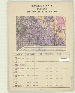
- Subject:
- Topical Subject: Land use and Geographic Subject: Franklin County (Ind.)
- Creator:
- Franklin County (Ind.). Land Use Planning Committee
- Publisher:
- United States. Bureau of Agricultural Economics
- Date Created:
- 1940
- Identifier:
- VAC3073-M-00144
- Genre:
- Thematic maps
- Geographic Location:
- Coordinates: W0851755 W0844855 N0393136 N0391605
- Related URL:
- Catalog URL: https://iucat.iu.edu/catalog/5126284
- Abstract:
- "Color reproduction by Bureau of Agricultural Economics, U.S.D.A." Includes chart showing type of land use, acreage, and recommended use.
- Call Number:
- G4093.F7G4 1940 .F73
- Caption:
- Imprint: [Washington, D.C.?] : U.S. Bureau of Agricultural Economics, [1940?]
- Physical Description:
- Dimensions: 15 x 21 cm, on sheet 38 x 28 cm and Scale: Scale not given.
- Alternate Identifier:
- Title Control Number: a5126284
- Persistent URL:
- https://purl.dlib.indiana.edu/iudl/images/VAC3073/VAC3073-M-00144
-
![Floyd County [Indiana] land use map : preliminary](https://iiif.uits.iu.edu/iiif/2/r207vr80n%2Ffiles%2Fba1ce671-118c-499c-8c40-0c3612b65e19/full/250,/0/default.jpg)
- Subject:
- Geographic Subject: Floyd County (Ind.) and Topical Subject: Land use
- Creator:
- Floyd County (Ind.). Land Use Planning Committee
- Publisher:
- Floyd County (Ind.). Land Use Planning Committee
- Date Created:
- 1940
- Identifier:
- VAC3073-M-00110
- Genre:
- Thematic maps
- Geographic Location:
- Coordinates: W0860159 W0854537 N0382508 N0381047
- Related URL:
- Catalog URL: https://iucat.iu.edu/catalog/5126281
- Abstract:
- Includes chart showing type of land use, acreage, and recommended use.
- Call Number:
- G4093.F5G4 1940 .F56
- Caption:
- Imprint: [New Albany, Ind.?] : The Committee, [1940?]
- Physical Description:
- Scale: Scale not given. and Dimensions: 18 x 17 cm, on sheet 39 x 28 cm
- Alternate Identifier:
- Title Control Number: a5126281
- Persistent URL:
- https://purl.dlib.indiana.edu/iudl/images/VAC3073/VAC3073-M-00110
-
![Spencer County [Indiana] land use map : preliminary](https://iiif.uits.iu.edu/iiif/2/1c18fj180%2Ffiles%2F9c0b4a8c-6bc8-420c-af21-908a4b5f3ba4/full/250,/0/default.jpg)
- Subject:
- Topical Subject: Land use and Geographic Subject: Spencer County (Ind.)
- Creator:
- Spencer County (Ind.). Land Use Planning Committee
- Publisher:
- Spencer County (Ind.). Land Use Planning Committee
- Date Created:
- 1940
- Identifier:
- VAC3073-M-00041
- Genre:
- Thematic maps
- Geographic Location:
- Coordinates: W0871606 W0864553 N0381218 N0374656
- Related URL:
- Catalog URL: https://iucat.iu.edu/catalog/5126542
- Abstract:
- Includes chart showing type of land use, acreage, and recommended use.
- Call Number:
- G4093.S5 G4 1940 .S64
- Caption:
- Imprint: [Rockport, Ind.?] : The Committee, [1940?]
- Physical Description:
- Dimensions: 27 x 25 cm, on sheet 39 x 28 cm and Scale: Scale not given.
- Alternate Identifier:
- Title Control Number: a5126542
- Persistent URL:
- https://purl.dlib.indiana.edu/iudl/images/VAC3073/VAC3073-M-00041
-
![Washington County [Indiana] land use map : preliminary](https://iiif.uits.iu.edu/iiif/2/vq280q904%2Ffiles%2F783115ab-1c66-4d7e-b7d2-60280c29643b/full/250,/0/default.jpg)
- Subject:
- Topical Subject: Land use and Geographic Subject: Washington County (Ind.)
- Creator:
- Washington County (Ind.). Land Use Planning Committee
- Publisher:
- Washington County (Ind.). Land Use Planning Committee
- Date Created:
- 1940
- Identifier:
- VAC3073-M-00034
- Genre:
- Maps
- Geographic Location:
- Coordinates: W0861836 W0855051 N0384700 N0382504
- Related URL:
- Catalog URL: https://iucat.iu.edu/catalog/5126654
- Abstract:
- Includes chart showing type of land use, acreage, and recommended use.
- Call Number:
- G4093.W5 G4 1940 .W37
- Caption:
- Imprint: [Salem, Ind.?] : The Committee, [1940?]
- Physical Description:
- Dimensions: 23 x 23 cm, on sheet 39 x 28 cm and Scale: Scale not given.
- Alternate Identifier:
- Title Control Number: a5126654
- Persistent URL:
- https://purl.dlib.indiana.edu/iudl/images/VAC3073/VAC3073-M-00034
-
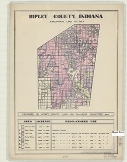
- Subject:
- Geographic Subject: Ripley County (Ind.) and Topical Subject: Land use
- Creator:
- Ripley County (Ind.). Land Use Planning Committee
- Publisher:
- United States. Bureau of Agricultural Economics
- Date Created:
- 1940
- Identifier:
- VAC3073-M-00030
- Genre:
- Thematic maps
- Geographic Location:
- Coordinates: W0852641 W0850354 N0391837 N0385446
- Related URL:
- Catalog URL: https://iucat.iu.edu/catalog/5126533
- Abstract:
- "Color reproduction by Bureau of Agricultural Economics, U.S.D.A." "8-21-40" Includes chart showing type of land use, acreage, and recomm...
- Call Number:
- G4093.R5 G4 1940 .R57
- Caption:
- Imprint: [Washington, D.C.?] : U.S. Bureau of Agricultural Economics, [1940]
- Physical Description:
- Dimensions: 21 x 16 cm, on sheet 38 x 28 cm and Scale: Scale not given.
- Alternate Identifier:
- Title Control Number: a5126533
- Persistent URL:
- https://purl.dlib.indiana.edu/iudl/images/VAC3073/VAC3073-M-00030
-
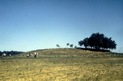
- Subject:
- Angel Mounds State Historic Site (Ind.)
- Date Created:
- 1940
- Identifier:
- VAD5943-005102
- Genre:
- Excavations & Fieldwork
- County:
- Vanderburgh
- Geographic Location:
- Site Name: Angel Mounds and Site Number: 12Vg1
- Abstract:
- Mound F at the start of excavatons
- Call Number:
- S6543
- Caption:
- Angel Md F Prior to Excavation
- Copyright Holder:
- Trustees of Indiana University
- Country:
- United States
- State/Province:
- Indiana
- Physical Description:
- 1 Slide: color, 35mm
- Persistent URL:
- http://purl.dlib.indiana.edu/iudl/gbl/VAD5943/VAD5943-005102
- Holding Location:
- Bloomington - Indiana University Museum of Archaeology and Anthropology
416 North Indiana Avenue
Bloomington, IN 47408
Contact at iumaa@indiana.edu, 812-855-6873
-
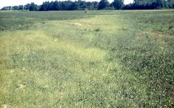
- Subject:
- Angel Mounds State Historic Site (Ind.)
- Date Created:
- 1940
- Identifier:
- VAD5943-005101
- Genre:
- Buildings & Landmarks
- County:
- Vanderburgh
- Geographic Location:
- Site Number: 12Vg1 and Site Name: Angel Mounds
- Abstract:
- Angel Mounds stockade
- Call Number:
- S2541
- Caption:
- Angel Stockade Line N. of Md. F.
- Copyright Holder:
- Trustees of Indiana University
- Country:
- United States
- State/Province:
- Indiana
- Physical Description:
- 1 Slide: color, 35mm
- Persistent URL:
- http://purl.dlib.indiana.edu/iudl/gbl/VAD5943/VAD5943-005101
- Holding Location:
- Bloomington - Indiana University Museum of Archaeology and Anthropology
416 North Indiana Avenue
Bloomington, IN 47408
Contact at iumaa@indiana.edu, 812-855-6873
-
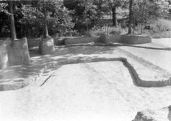
- Subject:
- Excavations (Archaeology) and Angel Mounds State Historic Site (Ind.)
- Date Created:
- 1940
- Identifier:
- VAD5943-003393
- Genre:
- Excavations & Fieldwork
- County:
- Vanderburgh
- Geographic Location:
- Site Name: Angel Mounds and Site Number: 12Vg1
- Abstract:
- Excavation in U-8-B
- Call Number:
- S1468
- Copyright Holder:
- Trustees of Indiana University
- Country:
- United States
- State/Province:
- Indiana
- Physical Description:
- 1 Slide: color, 35mm
- Persistent URL:
- http://purl.dlib.indiana.edu/iudl/gbl/VAD5943/VAD5943-003393
- Holding Location:
- Bloomington - Indiana University Museum of Archaeology and Anthropology
416 North Indiana Avenue
Bloomington, IN 47408
Contact at iumaa@indiana.edu, 812-855-6873
-

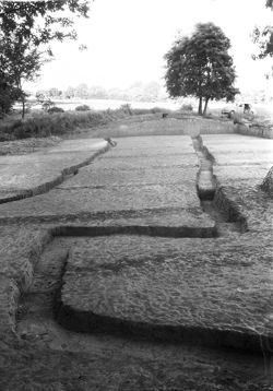
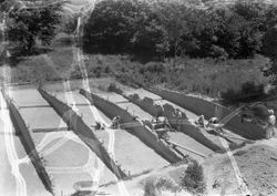
- Subject:
- Excavations (Archaeology) and Angel Mounds State Historic Site (Ind.)
- Date Created:
- 1940
- Identifier:
- VAD5943-003044
- Genre:
- Excavations & Fieldwork
- County:
- Vanderburgh
- Geographic Location:
- Site Name: Angel Mounds and Site Number: 12Vg1
- Abstract:
- Excavation in X-11-B
- Call Number:
- N3208
- Caption:
- P35/ Looking East Across A Part Of The Floor Of X-11-B Showing Apart Of A Large House Pattern. The Palisade Trench Follows The In Side Edge Of The Waste Pile...
- Copyright Holder:
- Trustees of Indiana University
- Country:
- United States
- State/Province:
- Indiana
- Physical Description:
- 1 Negative: b&w, 5 x 7 in.
- Persistent URL:
- http://purl.dlib.indiana.edu/iudl/gbl/VAD5943/VAD5943-003044
- Holding Location:
- Bloomington - Indiana University Museum of Archaeology and Anthropology
416 North Indiana Avenue
Bloomington, IN 47408
Contact at iumaa@indiana.edu, 812-855-6873
-
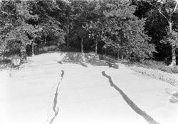
- Subject:
- Excavations (Archaeology) and Angel Mounds State Historic Site (Ind.)
- Date Created:
- 1940
- Identifier:
- VAD5943-003039
- Genre:
- Excavations & Fieldwork
- County:
- Vanderburgh
- Geographic Location:
- Site Number: 12Vg1 and Site Name: Angel Mounds
- Abstract:
- Excavation in X-11-B and X-11-C
- Call Number:
- N3177
- Caption:
- P4/View To The Northeast Of Work In The 0'-10' Trench Of X-11-B. The Area Covered By Tarpaulins, In The Foreground, Is X-11-C.
- Copyright Holder:
- Trustees of Indiana University
- Country:
- United States
- State/Province:
- Indiana
- Physical Description:
- 1 Negative: b&w, 5 x 7 in.
- Persistent URL:
- http://purl.dlib.indiana.edu/iudl/gbl/VAD5943/VAD5943-003039
- Holding Location:
- Bloomington - Indiana University Museum of Archaeology and Anthropology
416 North Indiana Avenue
Bloomington, IN 47408
Contact at iumaa@indiana.edu, 812-855-6873
-
- Subject:
- Angel Mounds State Historic Site (Ind.) and Excavations (Archaeology)
- Date Created:
- 1940
- Identifier:
- VAD5943-002785
- Genre:
- Excavations & Fieldwork
- County:
- Vanderburgh
- Geographic Location:
- Site Number: 12Vg1 and Site Name: Angel Mounds
- Abstract:
- Excavation in U-8-B
- Call Number:
- N2903
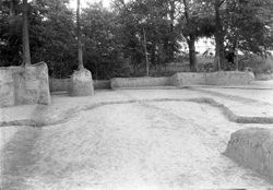
- Caption:
- P18/U-8-B.View To N. Of Bastion In Sub-Division. U-8-B Palisade With Bulge In Secondary Trench Beyond.
- Copyright Holder:
- Trustees of Indiana University
- Country:
- United States
- State/Province:
- Indiana
- Physical Description:
- 1 Negative: b&w, 5 x 7 in.
- Persistent URL:
- http://purl.dlib.indiana.edu/iudl/gbl/VAD5943/VAD5943-002785
- Holding Location:
- Bloomington - Indiana University Museum of Archaeology and Anthropology
416 North Indiana Avenue
Bloomington, IN 47408
Contact at iumaa@indiana.edu, 812-855-6873
-
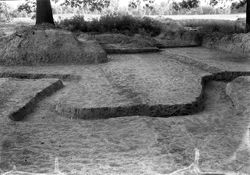
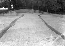
- Subject:
- Angel Mounds State Historic Site (Ind.) and Excavations (Archaeology)
- Date Created:
- 1940
- Identifier:
- VAD5943-002784
- Genre:
- Excavations & Fieldwork
- County:
- Vanderburgh
- Geographic Location:
- Site Number: 12Vg1 and Site Name: Angel Mounds
- Abstract:
- Excavation in U-8-B
- Call Number:
- N2902
- Caption:
- P17/U-8-B. View To The W. Of Palisade Trench And Bastion.
- Copyright Holder:
- Trustees of Indiana University
- Country:
- United States
- State/Province:
- Indiana
- Physical Description:
- 1 Negative: b&w, 5 x 7 in.
- Persistent URL:
- http://purl.dlib.indiana.edu/iudl/gbl/VAD5943/VAD5943-002784
- Holding Location:
- Bloomington - Indiana University Museum of Archaeology and Anthropology
416 North Indiana Avenue
Bloomington, IN 47408
Contact at iumaa@indiana.edu, 812-855-6873
-
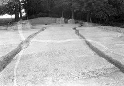
- Subject:
- Excavations (Archaeology) and Angel Mounds State Historic Site (Ind.)
- Date Created:
- 1940
- Identifier:
- VAD5943-002783
- Genre:
- Excavations & Fieldwork
- County:
- Vanderburgh
- Geographic Location:
- Site Name: Angel Mounds and Site Number: 12Vg1
- Abstract:
- Excavation in U-8-B
- Call Number:
- N2901
- Caption:
- P16/U-8-B. View To The E. Of Primary And Secondary Palisade Trenches In U-8-B. Bastion In Foreground.
- Copyright Holder:
- Trustees of Indiana University
- Country:
- United States
- State/Province:
- Indiana
- Physical Description:
- 1 Negative: b&w, 5 x 7 in.
- Persistent URL:
- http://purl.dlib.indiana.edu/iudl/gbl/VAD5943/VAD5943-002783
- Holding Location:
- Bloomington - Indiana University Museum of Archaeology and Anthropology
416 North Indiana Avenue
Bloomington, IN 47408
Contact at iumaa@indiana.edu, 812-855-6873
-
- Subject:
- Excavations (Archaeology) and Angel Mounds State Historic Site (Ind.)
- Date Created:
- 1940
- Identifier:
- VAD5943-002782
- Genre:
- Excavations & Fieldwork
- County:
- Vanderburgh
- Geographic Location:
- Site Name: Angel Mounds and Site Number: 12Vg1
- Abstract:
- Excavation in U-8-B
- Call Number:
- N2900
- Caption:
- P15/U-8-B. View to the S. Of Bastion in Sub-Division. U-8-B
- Copyright Holder:
- Trustees of Indiana University
- Country:
- United States
- State/Province:
- Indiana
- Physical Description:
- 1 Negative: b&w, 5 x 7 in.
- Persistent URL:
- http://purl.dlib.indiana.edu/iudl/gbl/VAD5943/VAD5943-002782
- Holding Location:
- Bloomington - Indiana University Museum of Archaeology and Anthropology
416 North Indiana Avenue
Bloomington, IN 47408
Contact at iumaa@indiana.edu, 812-855-6873
-
- Subject:
- Angel Mounds State Historic Site (Ind.) and Excavations (Archaeology)
- Date Created:
- 1940
- Identifier:
- VAD5943-002781
- Genre:
- Excavations & Fieldwork
- County:
- Vanderburgh
- Geographic Location:
- Site Number: 12Vg1 and Site Name: Angel Mounds
- Abstract:
- Excavation in U-8-B
- Call Number:
- N2899
- Caption:
- P14/U-8-B. View To N. Of Bastion In Palisade Wall Sub-Division U-8-B. Secondary Trench Is In Background. Trees Are In Decadent Slough Which Surrounds The Sit...
- Copyright Holder:
- Trustees of Indiana University
- Country:
- United States
- State/Province:
- Indiana
- Physical Description:
- 1 Negative: b&w, 5 x 7 in.
- Persistent URL:
- http://purl.dlib.indiana.edu/iudl/gbl/VAD5943/VAD5943-002781
- Holding Location:
- Bloomington - Indiana University Museum of Archaeology and Anthropology
416 North Indiana Avenue
Bloomington, IN 47408
Contact at iumaa@indiana.edu, 812-855-6873
-
- Subject:
- Excavations (Archaeology) and Angel Mounds State Historic Site (Ind.)
- Date Created:
- 1940
- Identifier:
- VAD5943-002779
- Genre:
- Excavations & Fieldwork
- County:
- Vanderburgh
- Geographic Location:
- Site Number: 12Vg1 and Site Name: Angel Mounds
- Abstract:
- Excavation in U-8-B
- Call Number:
- N2897
- Caption:
- P12/U-8-B.View To The W. Of Floor In Sub-Division U-8-B After Trench Walls Were Removed And Primary And Secondary Trenches Exposed. Bastion In Background.
- Copyright Holder:
- Trustees of Indiana University
- Country:
- United States
- State/Province:
- Indiana
- Physical Description:
- 1 Negative: b&w, 5 x 7 in.
- Persistent URL:
- http://purl.dlib.indiana.edu/iudl/gbl/VAD5943/VAD5943-002779
- Holding Location:
- Bloomington - Indiana University Museum of Archaeology and Anthropology
416 North Indiana Avenue
Bloomington, IN 47408
Contact at iumaa@indiana.edu, 812-855-6873
-
- Subject:
- Excavations (Archaeology) and Angel Mounds State Historic Site (Ind.)
- Date Created:
- 1940
- Identifier:
- VAD5943-002778
- Genre:
- Excavations & Fieldwork
- County:
- Vanderburgh
- Geographic Location:
- Site Number: 12Vg1 and Site Name: Angel Mounds
- Abstract:
- Excavation in U-8-B
- Call Number:
- N2896
- Caption:
- P11/U-8-B.View To W. Of Bastion and Palisade Trenches
- Copyright Holder:
- Trustees of Indiana University
- Country:
- United States
- State/Province:
- Indiana
- Physical Description:
- 1 Negative: b&w, 5 x 7 in.
- Persistent URL:
- http://purl.dlib.indiana.edu/iudl/gbl/VAD5943/VAD5943-002778
- Holding Location:
- Bloomington - Indiana University Museum of Archaeology and Anthropology
416 North Indiana Avenue
Bloomington, IN 47408
Contact at iumaa@indiana.edu, 812-855-6873
-
- Subject:
- Angel Mounds State Historic Site (Ind.) and Excavations (Archaeology)
- Date Created:
- 1940
- Identifier:
- VAD5943-002777
- Genre:
- Excavations & Fieldwork
- County:
- Vanderburgh
- Geographic Location:
- Site Name: Angel Mounds and Site Number: 12Vg1
- Abstract:
- Excavation in U-8-B
- Call Number:
- N2895
- Caption:
- P10/U-8-B. View To The N.E. From Photographic Tower. Workmen Removng Earth From Palisade Trenches.
- Copyright Holder:
- Trustees of Indiana University
- Country:
- United States
- State/Province:
- Indiana
- Physical Description:
- 1 Negative: b&w, 5 x 7 in.
- Persistent URL:
- http://purl.dlib.indiana.edu/iudl/gbl/VAD5943/VAD5943-002777
- Holding Location:
- Bloomington - Indiana University Museum of Archaeology and Anthropology
416 North Indiana Avenue
Bloomington, IN 47408
Contact at iumaa@indiana.edu, 812-855-6873
-
- Subject:
- Angel Mounds State Historic Site (Ind.) and Excavations (Archaeology)
- Date Created:
- 1940
- Identifier:
- VAD5943-002776
- Genre:
- Excavations & Fieldwork
- County:
- Vanderburgh
- Geographic Location:
- Site Name: Angel Mounds and Site Number: 12Vg1
- Abstract:
- Excavation in U-8-B
- Call Number:
- N2894
- Caption:
- Same As P8/U-8-B Except With Normal Lens
- Copyright Holder:
- Trustees of Indiana University
- Country:
- United States
- State/Province:
- Indiana
- Physical Description:
- 1 Negative: b&w, 5 x 7 in.
- Persistent URL:
- http://purl.dlib.indiana.edu/iudl/gbl/VAD5943/VAD5943-002776
- Holding Location:
- Bloomington - Indiana University Museum of Archaeology and Anthropology
416 North Indiana Avenue
Bloomington, IN 47408
Contact at iumaa@indiana.edu, 812-855-6873
-
- Subject:
- Excavations (Archaeology) and Angel Mounds State Historic Site (Ind.)
- Date Created:
- 1940
- Identifier:
- VAD5943-002774
- Genre:
- Excavations & Fieldwork
- County:
- Vanderburgh
- Geographic Location:
- Site Number: 12Vg1 and Site Name: Angel Mounds
- Call Number:
- N2892
- Caption:
- P7/U-8-B. Palisade Trench Faintly Visible Face Of Excavation
- Copyright Holder:
- Trustees of Indiana University
- Country:
- United States
- State/Province:
- Indiana
- Physical Description:
- 1 Negative: b&w, 5 x 7 in.
- Persistent URL:
- http://purl.dlib.indiana.edu/iudl/gbl/VAD5943/VAD5943-002774
- Holding Location:
- Bloomington - Indiana University Museum of Archaeology and Anthropology
416 North Indiana Avenue
Bloomington, IN 47408
Contact at iumaa@indiana.edu, 812-855-6873
-
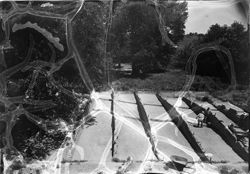
- Subject:
- Angel Mounds State Historic Site (Ind.) and Excavations (Archaeology)
- Date Created:
- 1940
- Identifier:
- VAD5943-002775
- Genre:
- Excavations & Fieldwork
- County:
- Vanderburgh
- Geographic Location:
- Site Name: Angel Mounds and Site Number: 12Vg1
- Abstract:
- Excavation in U-8-B
- Call Number:
- N2893
- Caption:
- P8/U-8-B. View To The N. from Photo - Graphic Tower Of Floor Exposed With Primary And Secondary Trenches Worked Out As They Extend From Face To Face Of The S...
- Copyright Holder:
- Trustees of Indiana University
- Country:
- United States
- State/Province:
- Indiana
- Physical Description:
- 1 Negative: b&w, 5 x 7 in.
- Persistent URL:
- http://purl.dlib.indiana.edu/iudl/gbl/VAD5943/VAD5943-002775
- Holding Location:
- Bloomington - Indiana University Museum of Archaeology and Anthropology
416 North Indiana Avenue
Bloomington, IN 47408
Contact at iumaa@indiana.edu, 812-855-6873
-
- Subject:
- Angel Mounds State Historic Site (Ind.) and Excavations (Archaeology)
- Date Created:
- 1940
- Identifier:
- VAD5943-002773
- Genre:
- Excavations & Fieldwork
- County:
- Vanderburgh
- Geographic Location:
- Site Number: 12Vg1 and Site Name: Angel Mounds
- Abstract:
- U-8-B floor
- Call Number:
- N2891
- Caption:
- P6/U-8-B. View Of Palisade Trench In L-5 Floor Looking N. June 15, 1940
- Copyright Holder:
- Trustees of Indiana University
- Country:
- United States
- State/Province:
- Indiana
- Physical Description:
- 1 Negative: b&w, 5 x 7 in.
- Persistent URL:
- http://purl.dlib.indiana.edu/iudl/gbl/VAD5943/VAD5943-002773
- Holding Location:
- Bloomington - Indiana University Museum of Archaeology and Anthropology
416 North Indiana Avenue
Bloomington, IN 47408
Contact at iumaa@indiana.edu, 812-855-6873
-
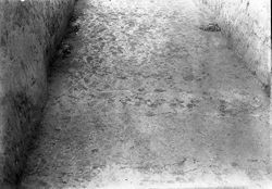
- Subject:
- Angel Mounds State Historic Site (Ind.) and Excavations (Archaeology)
- Date Created:
- 1940
- Identifier:
- VAD5943-002772
- Genre:
- Excavations & Fieldwork
- County:
- Vanderburgh
- Geographic Location:
- Site Name: Angel Mounds and Site Number: 12Vg1
- Abstract:
- U-8-B floor
- Call Number:
- N2890
- Caption:
- P5/U-8-B. View Downward And To the South Of Trench In L-5 Floor. June 15, 1940
- Copyright Holder:
- Trustees of Indiana University
- Country:
- United States
- State/Province:
- Indiana
- Physical Description:
- 1 Negative: b&w, 5 x 7 in.
- Persistent URL:
- http://purl.dlib.indiana.edu/iudl/gbl/VAD5943/VAD5943-002772
- Holding Location:
- Bloomington - Indiana University Museum of Archaeology and Anthropology
416 North Indiana Avenue
Bloomington, IN 47408
Contact at iumaa@indiana.edu, 812-855-6873
-
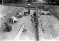
- Subject:
- Angel Mounds State Historic Site (Ind.) and Excavations (Archaeology)
- Date Created:
- 1940
- Identifier:
- VAD5943-002770
- Genre:
- Excavations & Fieldwork
- County:
- Vanderburgh
- Geographic Location:
- Site Number: 12Vg1 and Site Name: Angel Mounds
- Abstract:
- Workmen in U-8-B
- Call Number:
- N2888
- Caption:
- P3/U-8-B.Workmen Troweling Trench Floors And Face To Bring Out Evidence Of Palisade Trench. View Is To The North Through The R-4 Trench. June 15, 1940
- Copyright Holder:
- Trustees of Indiana University
- Country:
- United States
- State/Province:
- Indiana
- Physical Description:
- 1 Negative: b&w, 5 x 7 in.
- Persistent URL:
- http://purl.dlib.indiana.edu/iudl/gbl/VAD5943/VAD5943-002770
- Holding Location:
- Bloomington - Indiana University Museum of Archaeology and Anthropology
416 North Indiana Avenue
Bloomington, IN 47408
Contact at iumaa@indiana.edu, 812-855-6873
-
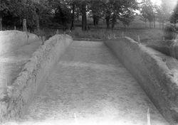
- Subject:
- Excavations (Archaeology) and Angel Mounds State Historic Site (Ind.)
- Date Created:
- 1940
- Identifier:
- VAD5943-002771
- Genre:
- Excavations & Fieldwork
- County:
- Vanderburgh
- Geographic Location:
- Site Number: 12Vg1 and Site Name: Angel Mounds
- Abstract:
- Excavation in U-8-B
- Call Number:
- N2889
- Caption:
- P4/U-8-B. View to the North Through the R-2 Trench with the Primary Palisade Trench Showing as a broad light streak from left to right across the picture bet...
- Copyright Holder:
- Trustees of Indiana University
- Country:
- United States
- State/Province:
- Indiana
- Physical Description:
- 1 Negative: b&w, 5 x 7 in.
- Persistent URL:
- http://purl.dlib.indiana.edu/iudl/gbl/VAD5943/VAD5943-002771
- Holding Location:
- Bloomington - Indiana University Museum of Archaeology and Anthropology
416 North Indiana Avenue
Bloomington, IN 47408
Contact at iumaa@indiana.edu, 812-855-6873
-
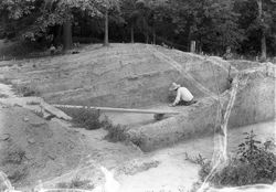
- Subject:
- Excavations (Archaeology) and Angel Mounds State Historic Site (Ind.)
- Date Created:
- 1940
- Identifier:
- VAD5943-002769
- Genre:
- Excavations & Fieldwork
- County:
- Vanderburgh
- Geographic Location:
- Site Name: Angel Mounds and Site Number: 12Vg1
- Abstract:
- Excavation in U-8-B
- Call Number:
- N2887
- Caption:
- P2/U-8-B. View To N. And W. Of Trenches Excavated Across Wall In U-8-B Workman Is Troweling Floor To Bring Out The Palisade Trench. June 15, 1940
- Copyright Holder:
- Trustees of Indiana University
- Country:
- United States
- State/Province:
- Indiana
- Physical Description:
- 1 Negative: b&w, 5 x 7 in.
- Persistent URL:
- http://purl.dlib.indiana.edu/iudl/gbl/VAD5943/VAD5943-002769
- Holding Location:
- Bloomington - Indiana University Museum of Archaeology and Anthropology
416 North Indiana Avenue
Bloomington, IN 47408
Contact at iumaa@indiana.edu, 812-855-6873
-
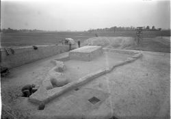
- Subject:
- Excavations (Archaeology) and Angel Mounds State Historic Site (Ind.)
- Date Created:
- 1940
- Identifier:
- VAD5943-002610
- Genre:
- Excavations & Fieldwork
- County:
- Vanderburgh
- Geographic Location:
- Site Number: 12Vg1 and Site Name: Angel Mounds
- Abstract:
- Mound F excavation
- Call Number:
- N2098
- Caption:
- P25/Md.F View To The S.W. Of Working Floor On West Half Of Mound Showing Outline Of Sand Area And Profile Pillar.
- Copyright Holder:
- Trustees of Indiana University
- Country:
- United States
- State/Province:
- Indiana
- Physical Description:
- 1 Negative: b&w, 5 x 7 in.
- Persistent URL:
- http://purl.dlib.indiana.edu/iudl/gbl/VAD5943/VAD5943-002610
- Holding Location:
- Bloomington - Indiana University Museum of Archaeology and Anthropology
416 North Indiana Avenue
Bloomington, IN 47408
Contact at iumaa@indiana.edu, 812-855-6873
-
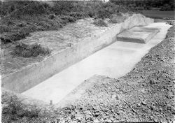
- Subject:
- Angel Mounds State Historic Site (Ind.) and Excavations (Archaeology)
- Date Created:
- 1940
- Identifier:
- VAD5943-002585
- Genre:
- Excavations & Fieldwork
- County:
- Vanderburgh
- Geographic Location:
- Site Name: Angel Mounds and Site Number: 12Vg1
- Abstract:
- Mound F excavation
- Call Number:
- N2085
- Caption:
- P12/Md.F 30' To 40' Trench And 40' Face. View To East + North. 8-12-40
- Copyright Holder:
- Trustees of Indiana University
- Country:
- United States
- State/Province:
- Indiana
- Physical Description:
- 1 Negative: b&w, 5 x 7 in.
- Persistent URL:
- http://purl.dlib.indiana.edu/iudl/gbl/VAD5943/VAD5943-002585
- Holding Location:
- Bloomington - Indiana University Museum of Archaeology and Anthropology
416 North Indiana Avenue
Bloomington, IN 47408
Contact at iumaa@indiana.edu, 812-855-6873
-
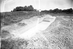
- Subject:
- Angel Mounds State Historic Site (Ind.) and Excavations (Archaeology)
- Date Created:
- 1940
- Identifier:
- VAD5943-002584
- Genre:
- Excavations & Fieldwork
- County:
- Vanderburgh
- Geographic Location:
- Site Number: 12Vg1 and Site Name: Angel Mounds
- Abstract:
- Mound F excavation
- Call Number:
- N2086
- Caption:
- P13/Md.F Same As P12 Except Taken With Wide Angle Lens.
- Copyright Holder:
- Trustees of Indiana University
- Country:
- United States
- State/Province:
- Indiana
- Physical Description:
- 1 Negative: b&w, 5 x 7 in.
- Persistent URL:
- http://purl.dlib.indiana.edu/iudl/gbl/VAD5943/VAD5943-002584
- Holding Location:
- Bloomington - Indiana University Museum of Archaeology and Anthropology
416 North Indiana Avenue
Bloomington, IN 47408
Contact at iumaa@indiana.edu, 812-855-6873
-
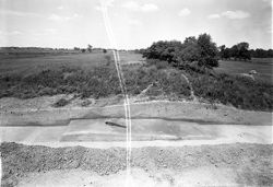
- Subject:
- Angel Mounds State Historic Site (Ind.) and Excavations (Archaeology)
- Date Created:
- 1940
- Identifier:
- VAD5943-002583
- Genre:
- Excavations & Fieldwork
- County:
- Vanderburgh
- Geographic Location:
- Site Number: 12Vg1 and Site Name: Angel Mounds
- Abstract:
- Mound F excavation
- Call Number:
- N2087
- Caption:
- P14/Md.F View To North Of 30-40 Foot Trench Taken From Tower. Old Surface in Trench
- Copyright Holder:
- Trustees of Indiana University
- Country:
- United States
- State/Province:
- Indiana
- Physical Description:
- 1 Negative: b&w, 5 x 7 in.
- Persistent URL:
- http://purl.dlib.indiana.edu/iudl/gbl/VAD5943/VAD5943-002583
- Holding Location:
- Bloomington - Indiana University Museum of Archaeology and Anthropology
416 North Indiana Avenue
Bloomington, IN 47408
Contact at iumaa@indiana.edu, 812-855-6873
-
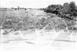
- Subject:
- Excavations (Archaeology) and Angel Mounds State Historic Site (Ind.)
- Date Created:
- 1940
- Identifier:
- VAD5943-002582
- Genre:
- Excavations & Fieldwork
- County:
- Vanderburgh
- Geographic Location:
- Site Name: Angel Mounds and Site Number: 12Vg1
- Abstract:
- Mound F excavation
- Call Number:
- N2088
- Caption:
- P15/Md.F View To North Of 30'-40' Trench. Old Surface Left Standing In Trench.
- Copyright Holder:
- Trustees of Indiana University
- Country:
- United States
- State/Province:
- Indiana
- Physical Description:
- 1 Negative: b&w, 5 x 7 in.
- Persistent URL:
- http://purl.dlib.indiana.edu/iudl/gbl/VAD5943/VAD5943-002582
- Holding Location:
- Bloomington - Indiana University Museum of Archaeology and Anthropology
416 North Indiana Avenue
Bloomington, IN 47408
Contact at iumaa@indiana.edu, 812-855-6873
-
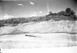
- Subject:
- Angel Mounds State Historic Site (Ind.) and Excavations (Archaeology)
- Date Created:
- 1940
- Identifier:
- VAD5943-002581
- Genre:
- Excavations & Fieldwork
- County:
- Vanderburgh
- Geographic Location:
- Site Name: Angel Mounds and Site Number: 12Vg1
- Abstract:
- Mound F excavation
- Call Number:
- N2089
- Caption:
- P16/Md.F View To North Of 30-40' Trench. Old Surface Inclining From 30-40' Lines In Situ In Foreground.
- Copyright Holder:
- Trustees of Indiana University
- Country:
- United States
- State/Province:
- Indiana
- Physical Description:
- 1 Negative: b&w, 5 x 7 in.
- Persistent URL:
- http://purl.dlib.indiana.edu/iudl/gbl/VAD5943/VAD5943-002581
- Holding Location:
- Bloomington - Indiana University Museum of Archaeology and Anthropology
416 North Indiana Avenue
Bloomington, IN 47408
Contact at iumaa@indiana.edu, 812-855-6873
-
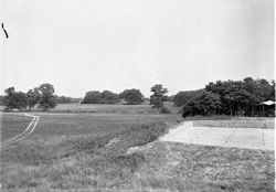
- Subject:
- Angel Mounds State Historic Site (Ind.) and Excavations (Archaeology)
- Date Created:
- 1940
- Identifier:
- VAD5943-002580
- Genre:
- Excavations & Fieldwork
- County:
- Vanderburgh
- Geographic Location:
- Site Name: Angel Mounds and Site Number: 12Vg1
- Abstract:
- Mound F excavation
- Call Number:
- N2097
- Caption:
- P24/Md.F View To The East And North From Photographic Tower Set West Of Md.F. The 386.11 Level On Md.F Is At The Right Mound A Shows In The Center Background...
- Copyright Holder:
- Trustees of Indiana University
- Country:
- United States
- State/Province:
- Indiana
- Physical Description:
- 1 Negative: b&w, 5 x 7 in.
- Persistent URL:
- http://purl.dlib.indiana.edu/iudl/gbl/VAD5943/VAD5943-002580
- Holding Location:
- Bloomington - Indiana University Museum of Archaeology and Anthropology
416 North Indiana Avenue
Bloomington, IN 47408
Contact at iumaa@indiana.edu, 812-855-6873
-
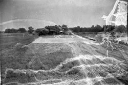
- Subject:
- Angel Mounds State Historic Site (Ind.) and Excavations (Archaeology)
- Date Created:
- 1940
- Identifier:
- VAD5943-002579
- Genre:
- Excavations & Fieldwork
- County:
- Vanderburgh
- Geographic Location:
- Site Name: Angel Mounds and Site Number: 12Vg1
- Abstract:
- Mound F at 386.11 foot level
- Call Number:
- N2096
- Caption:
- P23/Md.F Same As P22 Except Taken With Series III Wide Angle Lens.
- Copyright Holder:
- Trustees of Indiana University
- Country:
- United States
- State/Province:
- Indiana
- Physical Description:
- 1 Negative: b&w, 5 x 7 in.
- Persistent URL:
- http://purl.dlib.indiana.edu/iudl/gbl/VAD5943/VAD5943-002579
- Holding Location:
- Bloomington - Indiana University Museum of Archaeology and Anthropology
416 North Indiana Avenue
Bloomington, IN 47408
Contact at iumaa@indiana.edu, 812-855-6873
-
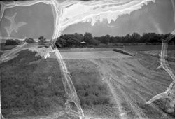
- Subject:
- Angel Mounds State Historic Site (Ind.)
- Date Created:
- 1940
- Identifier:
- VAD5943-002578
- Genre:
- Excavations & Fieldwork
- County:
- Vanderburgh
- Geographic Location:
- Site Name: Angel Mounds and Site Number: 12Vg1
- Abstract:
- Mound F at 386.11 foot level
- Call Number:
- N2095
- Caption:
- P22/Md.F Same As P20 Exccept Taken With Series III C Wide Angle Lens.
- Copyright Holder:
- Trustees of Indiana University
- Country:
- United States
- State/Province:
- Indiana
- Physical Description:
- 1 Negative: b&w, 5 x 7 in.
- Persistent URL:
- http://purl.dlib.indiana.edu/iudl/gbl/VAD5943/VAD5943-002578
- Holding Location:
- Bloomington - Indiana University Museum of Archaeology and Anthropology
416 North Indiana Avenue
Bloomington, IN 47408
Contact at iumaa@indiana.edu, 812-855-6873
-
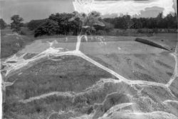
- Subject:
- Angel Mounds State Historic Site (Ind.) and Excavations (Archaeology)
- Date Created:
- 1940
- Identifier:
- VAD5943-002577
- Genre:
- Excavations & Fieldwork
- County:
- Vanderburgh
- Geographic Location:
- Site Name: Angel Mounds and Site Number: 12Vg1
- Abstract:
- Mound F at 386.11 foot level
- Call Number:
- N2094
- Caption:
- P21/Md.F Same As P20 Except Workmen Are Not Included.
- Copyright Holder:
- Trustees of Indiana University
- Country:
- United States
- State/Province:
- Indiana
- Physical Description:
- 1 Negative: b&w, 5 x 7 in.
- Persistent URL:
- http://purl.dlib.indiana.edu/iudl/gbl/VAD5943/VAD5943-002577
- Holding Location:
- Bloomington - Indiana University Museum of Archaeology and Anthropology
416 North Indiana Avenue
Bloomington, IN 47408
Contact at iumaa@indiana.edu, 812-855-6873
-
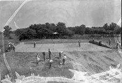
- Subject:
- Excavations (Archaeology) and Angel Mounds State Historic Site (Ind.)
- Date Created:
- 1940
- Identifier:
- VAD5943-002576
- Genre:
- Excavations & Fieldwork
- County:
- Vanderburgh
- Geographic Location:
- Site Number: 12Vg1 and Site Name: Angel Mounds
- Abstract:
- Mound F at 386.11 foot level
- Call Number:
- N2093
- Caption:
- P20/Md.F View To The East Of Floor Established On Wed. F At The 386.11 Foot Level. The Picture Was Taken From The Photographic Tower. The Face In The Backgro...
- Copyright Holder:
- Trustees of Indiana University
- Country:
- United States
- State/Province:
- Indiana
- Physical Description:
- 1 Negative: b&w, 5 x 7 in.
- Persistent URL:
- http://purl.dlib.indiana.edu/iudl/gbl/VAD5943/VAD5943-002576
- Holding Location:
- Bloomington - Indiana University Museum of Archaeology and Anthropology
416 North Indiana Avenue
Bloomington, IN 47408
Contact at iumaa@indiana.edu, 812-855-6873
-
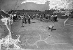
- Subject:
- Excavations (Archaeology) and Angel Mounds State Historic Site (Ind.)
- Date Created:
- 1940
- Identifier:
- VAD5943-002575
- Genre:
- Excavations & Fieldwork and People & Institutions
- Geographic Location:
- Site Name: Angel Mounds and Site Number: 12Vg1
- Abstract:
- Mound F excavation
- Call Number:
- N2092
- Caption:
- P19/Md.F View To The West Of Floor Being Prepared At The 386.11 Foot Level On Md.F.
- Copyright Holder:
- Trustees of Indiana University
- Country:
- United States
- State/Province:
- Indiana
- Physical Description:
- 1 Negative: b&w, 5 x 7 in.
- Persistent URL:
- http://purl.dlib.indiana.edu/iudl/gbl/VAD5943/VAD5943-002575
- Holding Location:
- Bloomington - Indiana University Museum of Archaeology and Anthropology
416 North Indiana Avenue
Bloomington, IN 47408
Contact at iumaa@indiana.edu, 812-855-6873
-
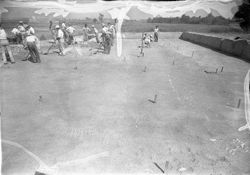
- Subject:
- Excavations (Archaeology) and Angel Mounds State Historic Site (Ind.)
- Date Created:
- 1940
- Identifier:
- VAD5943-002574
- Genre:
- People & Institutions and Excavations & Fieldwork
- County:
- Vanderburgh
- Geographic Location:
- Site Number: 12Vg1 and Site Name: Angel Mounds
- Abstract:
- Mound F excavation
- Call Number:
- N2091
- Caption:
- P18/Md.F View To The North Of Floor Being Prepared At The 386.11 Foot Level On Md.F West Of The Midline. The 150' Line Is The Face In The Background.
- Copyright Holder:
- Trustees of Indiana University
- Country:
- United States
- State/Province:
- Indiana
- Physical Description:
- 1 Negative: b&w, 5 x 7 in.
- Persistent URL:
- http://purl.dlib.indiana.edu/iudl/gbl/VAD5943/VAD5943-002574
- Holding Location:
- Bloomington - Indiana University Museum of Archaeology and Anthropology
416 North Indiana Avenue
Bloomington, IN 47408
Contact at iumaa@indiana.edu, 812-855-6873
-
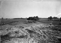
- Subject:
- Excavations (Archaeology) and Angel Mounds State Historic Site (Ind.)
- Date Created:
- 1940
- Identifier:
- VAD5943-002573
- Genre:
- People & Institutions and Excavations & Fieldwork
- County:
- Vanderburgh
- Geographic Location:
- Site Number: 12Vg1 and Site Name: Angel Mounds
- Abstract:
- Mound F excavation
- Call Number:
- N2090
- Caption:
- P17/Md.F 50' Face. View To N.E. Of 50' Face With Workmen Removing Vegetation Preparatory To Removing Top Of Mound Horizontally. Primary Mound Surface...
- Copyright Holder:
- Trustees of Indiana University
- Country:
- United States
- State/Province:
- Indiana
- Physical Description:
- 1 Negative: b&w, 5 x 7 in.
- Persistent URL:
- http://purl.dlib.indiana.edu/iudl/gbl/VAD5943/VAD5943-002573
- Holding Location:
- Bloomington - Indiana University Museum of Archaeology and Anthropology
416 North Indiana Avenue
Bloomington, IN 47408
Contact at iumaa@indiana.edu, 812-855-6873
-
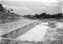
- Subject:
- Angel Mounds State Historic Site (Ind.) and Excavations (Archaeology)
- Date Created:
- 1940
- Identifier:
- VAD5943-002572
- Genre:
- Excavations & Fieldwork
- County:
- Vanderburgh
- Geographic Location:
- Site Number: 12Vg1 and Site Name: Angel Mounds
- Abstract:
- Mound F excavation
- Call Number:
- N2076
- Caption:
- P3/Md. F View To East Of 10 To 20' Trench.
- Copyright Holder:
- Trustees of Indiana University
- Country:
- United States
- State/Province:
- Indiana
- Physical Description:
- 1 Negative: b&w, 5 x 7 in.
- Persistent URL:
- http://purl.dlib.indiana.edu/iudl/gbl/VAD5943/VAD5943-002572
- Holding Location:
- Bloomington - Indiana University Museum of Archaeology and Anthropology
416 North Indiana Avenue
Bloomington, IN 47408
Contact at iumaa@indiana.edu, 812-855-6873
-
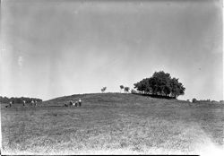
- Subject:
- Excavations (Archaeology) and Angel Mounds State Historic Site (Ind.)
- Date Created:
- 1940
- Identifier:
- VAD5943-002571
- Genre:
- Excavations & Fieldwork
- County:
- Vanderburgh
- Geographic Location:
- Site Number: 12Vg1 and Site Name: Angel Mounds
- Abstract:
- Workmen beginning Mound F excavation.
- Call Number:
- N2075
- Caption:
- P2/Md.F Mound F. View To N.W. Showing Men Starting 0'-10' Trench
- Copyright Holder:
- Trustees of Indiana University
- Country:
- United States
- State/Province:
- Indiana
- Physical Description:
- 1 Negative: b&w, 5 x 7 in.
- Persistent URL:
- http://purl.dlib.indiana.edu/iudl/gbl/VAD5943/VAD5943-002571
- Holding Location:
- Bloomington - Indiana University Museum of Archaeology and Anthropology
416 North Indiana Avenue
Bloomington, IN 47408
Contact at iumaa@indiana.edu, 812-855-6873
-
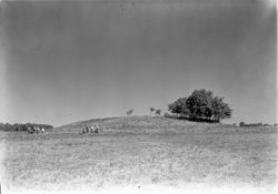
- Subject:
- Excavations (Archaeology) and Angel Mounds State Historic Site (Ind.)
- Date Created:
- 1940
- Identifier:
- VAD5943-002570
- Genre:
- Excavations & Fieldwork
- County:
- Vanderburgh
- Geographic Location:
- Site Number: 12Vg1 and Site Name: Angel Mounds
- Abstract:
- Workmen beginning Mound F excavation.
- Call Number:
- N2074
- Caption:
- P1/Md. F View To N.W. Of Md.F With Workmen Startng Preliminary Trench Along 0' Line
- Copyright Holder:
- Trustees of Indiana University
- Country:
- United States
- State/Province:
- Indiana
- Physical Description:
- 1 Negative: b&w, 5 x 7 in.
- Persistent URL:
- http://purl.dlib.indiana.edu/iudl/gbl/VAD5943/VAD5943-002570
- Holding Location:
- Bloomington - Indiana University Museum of Archaeology and Anthropology
416 North Indiana Avenue
Bloomington, IN 47408
Contact at iumaa@indiana.edu, 812-855-6873
-
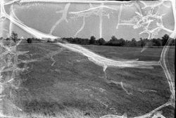
- Subject:
- Angel Mounds State Historic Site (Ind.)
- Date Created:
- 1940
- Identifier:
- VAD5943-002524
- Genre:
- Excavations & Fieldwork
- County:
- Vanderburgh
- Geographic Location:
- Site Name: Angel Mounds and Site Number: 12Vg1
- Abstract:
- A view of the Angel Mounds site showing the palisade wall.
- Call Number:
- N1673
- Caption:
- A.M. Same As Misc. 5
- Copyright Holder:
- Trustees of Indiana University
- Country:
- United States
- State/Province:
- Indiana
- Physical Description:
- 1 Negative: b&w, 5 x 7 in.
- Persistent URL:
- http://purl.dlib.indiana.edu/iudl/gbl/VAD5943/VAD5943-002524
- Holding Location:
- Bloomington - Indiana University Museum of Archaeology and Anthropology
416 North Indiana Avenue
Bloomington, IN 47408
Contact at iumaa@indiana.edu, 812-855-6873
-
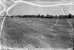
- Subject:
- Angel Mounds State Historic Site (Ind.)
- Date Created:
- 1940
- Identifier:
- VAD5943-002523
- Genre:
- Excavations & Fieldwork
- County:
- Vanderburgh
- Geographic Location:
- Site Number: 12Vg1 and Site Name: Angel Mounds
- Abstract:
- A view of the Angel Mounds site showing the palisade wall.
- Call Number:
- N1672
- Caption:
- A.M. Wall North Of Md. F. Taken 9-3-40 When Plantain Was Dead
- Copyright Holder:
- Trustees of Indiana University
- Country:
- United States
- State/Province:
- Indiana
- Physical Description:
- 1 Negative: b&w, 5 x 7 in.
- Persistent URL:
- http://purl.dlib.indiana.edu/iudl/gbl/VAD5943/VAD5943-002523
- Holding Location:
- Bloomington - Indiana University Museum of Archaeology and Anthropology
416 North Indiana Avenue
Bloomington, IN 47408
Contact at iumaa@indiana.edu, 812-855-6873
-
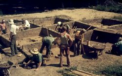
- Subject:
- Angel Mounds State Historic Site (Ind.), United States. Works Progress Administration., and Excavations (Archaeology)
- Date Created:
- 1940
- Identifier:
- VAD5943-002508
- Genre:
- People & Institutions and Excavations & Fieldwork
- County:
- Vanderburgh
- Geographic Location:
- Site Number: 12Vg1 and Site Name: Angel Mounds
- Abstract:
- Works Progress Administration (WPA) excavation at Angel Mounds
- Call Number:
- S2521
- Caption:
- WPA Angel Villages
- Copyright Holder:
- Trustees of Indiana University
- Country:
- United States
- State/Province:
- Indiana
- Physical Description:
- 1 Slide: color, 35mm
- Persistent URL:
- http://purl.dlib.indiana.edu/iudl/gbl/VAD5943/VAD5943-002508
- Holding Location:
- Bloomington - Indiana University Museum of Archaeology and Anthropology
416 North Indiana Avenue
Bloomington, IN 47408
Contact at iumaa@indiana.edu, 812-855-6873
-
- Subject:
- Angel Mounds State Historic Site (Ind.)
- Date Created:
- 1940
- Identifier:
- VAD5943-000176
- Genre:
- Excavations & Fieldwork
- County:
- Vanderburgh
- Geographic Location:
- Site Number: 12Vg1 and Site Name: Angel Mounds
- Abstract:
- Setting grid stakes on conical offset at Angel Mounds, Mound A.
- Call Number:
- N1975
- Caption:
- P1/Md.A Setting Grid Stakes On Conical Offset 2
- Copyright Holder:
- Trustees of Indiana University
- Country:
- United States
- State/Province:
- Indiana
- Physical Description:
- 1 Negative: b&w, 4 x 5 in.
- Persistent URL:
- http://purl.dlib.indiana.edu/iudl/gbl/VAD5943/VAD5943-000176
- Holding Location:
- Bloomington - Indiana University Museum of Archaeology and Anthropology
416 North Indiana Avenue
Bloomington, IN 47408
Contact at iumaa@indiana.edu, 812-855-6873
-

- Description:
- Event Name: World War I and Date of Photograph: 1962-07-31
- Subject:
- Topical: Graves
- Series:
- Groups
- Creator:
- Montgomery, Pauline
- Date Created:
- 1940
- Identifier:
- VAE0886-001879
- Geographic Location:
- Church Cemetery ?
- Abstract:
- There is no record for this image.
- Caption:
- Donor's Image Number: 1235, Ledger Page/ Entry Number: 129/8, and Death Date: 1940
- City:
- Jasper
- Copyright Holder:
- Indiana University
- Country:
- United States
- State/Province:
- Indiana
- Alternate Identifier:
- C386
- Persistent URL:
- http://purl.dlib.indiana.edu/iudl/archives/VAE0886/VAE0886-001879
- Holding Location:
- Bloomington - University Archives
Wells Library E460
1320 E 10th St.
Bloomington, IN 47405
Contact at archives@indiana.edu, 812-855-1127
-
- Description:
- Event Name: World War I and Date of Photograph: 1962-07-31
- Subject:
- Topical: Graves and Topical: Firearms
- Series:
- Groups
- Creator:
- Montgomery, Pauline
- Date Created:
- 1940
- Identifier:
- VAE0886-001503
- Caption:
- Death Date: 1940, Ledger Page/ Entry Number: 129/9, Age/Gender: 47/M, and Donor's Image Number: 1235A
- City:
- Bedford
- Copyright Holder:
- Indiana University
- Country:
- United States
- State/Province:
- Indiana
- Alternate Identifier:
- C386
- Persistent URL:
- http://purl.dlib.indiana.edu/iudl/archives/VAE0886/VAE0886-001503
- Holding Location:
- Bloomington - University Archives
Wells Library E460
1320 E 10th St.
Bloomington, IN 47405
Contact at archives@indiana.edu, 812-855-1127
-
- Description:
- Event Name: World War I and Date of Photograph: 1962-08-04
- Subject:
- Topical: Graves, Topical: Uniforms, and Topical: Military decorations
- Series:
- Groups
- Creator:
- Montgomery, Pauline
- Date Created:
- 1940
- Identifier:
- VAE0886-001422
- Caption:
- Death Date: 1940, Donor's Image Number: 1342A, Personal Name, Age/Gender: Wallner, Michael F., 47/M, and Ledger Page/ Entry Number: 145/9
- City:
- Bedford
- Copyright Holder:
- Indiana University
- Country:
- United States
- State/Province:
- Indiana
- Alternate Identifier:
- C386
- Persistent URL:
- http://purl.dlib.indiana.edu/iudl/archives/VAE0886/VAE0886-001422
- Holding Location:
- Bloomington - University Archives
Wells Library E460
1320 E 10th St.
Bloomington, IN 47405
Contact at archives@indiana.edu, 812-855-1127
-
- Description:
- Date of Photograph: 1962-08-04
- Subject:
- Topical: Military decorations, Topical: Graves, and Topical: Uniforms
- Series:
- Groups
- Creator:
- Montgomery, Pauline
- Date Created:
- 1940
- Identifier:
- VAE0886-001421
- Caption:
- Death Date: 1940, Donor's Image Number: 1342, Ledger Page/ Entry Number: 145/8, and Personal Name, Age/Gender: Wallner, Michael F., 47/M
- City:
- Bedford
- Copyright Holder:
- Indiana University
- Country:
- United States
- State/Province:
- Indiana
- Alternate Identifier:
- C386
- Persistent URL:
- http://purl.dlib.indiana.edu/iudl/archives/VAE0886/VAE0886-001421
- Holding Location:
- Bloomington - University Archives
Wells Library E460
1320 E 10th St.
Bloomington, IN 47405
Contact at archives@indiana.edu, 812-855-1127
