
Search Constraints
Search Results
-
![Jackson County [Indiana] land use map [map] : preliminary](https://iiif.uits.iu.edu/iiif/2/b27750001%2Ffiles%2F79afb54a-ede0-4189-97ab-813c27a4f6d8/full/250,/0/default.jpg)
- Subject:
- Geographic Subject: Jackson County (Ind.) and Topical Subject: Land use
- Creator:
- Jackson County (Ind.). Land Use Planning Committee
- Publisher:
- Jackson County (Ind.). Land Use Planning Committee
- Date Created:
- 1941
- Identifier:
- VAC3073-M-00813
- Genre:
- Thematic maps
- Geographic Location:
- Coordinates: W0861905 W0854742 N0390416 N0384330
- Related URL:
- Catalog URL: https://iucat.iu.edu/catalog/4989649
- Abstract:
- Includes chart showing type of land use, acreage, and recommended use.
- Call Number:
- G4093.J2 G4 1941 .J33
- Caption:
- Imprint: [Brownstown, Ind.?] : The Committee, [between 1941-1946?]
- Physical Description:
- Dimensions: 21 x 24 cm, on sheet 39 x 28 cm and Scale: Scale not given.
- Alternate Identifier:
- Title Control Number: a4989649
- Persistent URL:
- https://purl.dlib.indiana.edu/iudl/images/VAC3073/VAC3073-M-00813
-
- Description:
- 1908
- Subject:
- Topical Subject: Soviet Union, Geographic Subject: Dzheguta, and Topical Subject: Maps
- Publisher:
- НКЗ СССР Сельхозаэросъемка
- Language:
- Russian
- Date Created:
- 1941
- Identifier:
- VAC9619-000718
- Genre:
- Topographic Maps and Military Maps
- Geographic Location:
- Coordinates: 43.6667, 42, 44, 42.5
- Related URL:
- Catalog URL: https://iucat.iu.edu/catalog/5020129 and Download GeoTIFF: https://drive.google.com/open?id=1kp0kGErywYJdw2pwrWDo3C-X9cu0C8Xk
- Abstract:
- Modern area represented: Dzheguta, Karachayevo-Cherkesiya Republic, Russia
- Call Number:
- G7000 s100 .S7 sheet K-38-1
- Caption:
- Временное издание,Для служебного пользования
- City:
- Джегутинский (Dzhegutinskiy)
- Copyright Holder:
- No Copyright - United States
- Country:
- СССР (USSR)
- State/Province:
- Орджоникидзевский край (Ordzhonikidze kray) and РСФСР (RSFSR)
- Physical Description:
- Scale: 1:100,000
- Persistent URL:
- http://purl.dlib.indiana.edu/iudl/images/VAC9619/VAC9619-000718
- Provenance:
- DMA Topographic Center, Army Map Service Library, OMAHA, Library of Congress Geography & Map Division
-
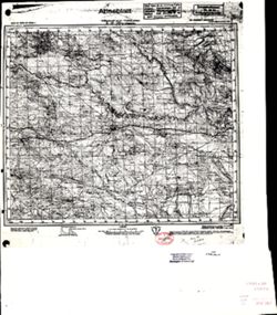
- Description:
- 1908
- Subject:
- Geographic Subject: Kislovodsk, Topical Subject: Soviet Union, and Topical Subject: Maps
- Publisher:
- НКЗ СССР Сельхозаэросъемка
- Language:
- Russian
- Date Created:
- 1941
- Identifier:
- VAC9619-000730
- Genre:
- Military Maps and Topographic Maps
- Geographic Location:
- Coordinates: 43.6667, 42.5, 44, 43
- Related URL:
- Catalog URL: https://iucat.iu.edu/catalog/5020129 and Download GeoTIFF: https://drive.google.com/open?id=1hE8Lj11I3DMGaxuNgdEk19cXKHishQi_
- Abstract:
- Modern area represented: Kislovodsk, Stavropol kray, Russia
- Call Number:
- G7000 s100 .S7 sheet K-38-2
- Caption:
- Для служебного пользования
- City:
- Кисловодск (Kislovodsk)
- Copyright Holder:
- No Copyright - United States
- Country:
- СССР (USSR)
- State/Province:
- Карачаевская автономная область (Karachay Autonomous Oblast), Орджоникидзевский край (Ordzhonikidze kray), РСФСР (RSFSR), and Кабардино-Балкарская АССР (Kaba...
- Physical Description:
- Scale: 1:100,000
- Persistent URL:
- http://purl.dlib.indiana.edu/iudl/images/VAC9619/VAC9619-000730
- Provenance:
- DMA Topographic Center, Atlasblatt, Army Map Service Library, Library of Congress Geography & Map Division, OMAHA
-
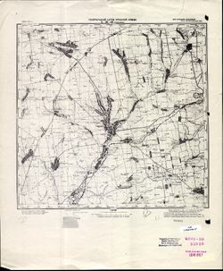
- Description:
- 1907
- Subject:
- Topical Subject: Soviet Union, Geographic Subject: Perekischkjul, and Topical Subject: Maps
- Publisher:
- Генеральный штаб Красной Армии
- Language:
- Russian
- Date Created:
- 1941
- Identifier:
- VAC9619-000892
- Genre:
- Military Maps and Topographic Maps
- Geographic Location:
- Coordinates: 40.3333, 49, 40.6667, 49.5
- Related URL:
- Download GeoTIFF: https://drive.google.com/open?id=1YAs8jfBXsWsytsvHAupvINf6BPXNHt5c and Catalog URL: https://iucat.iu.edu/catalog/5020129
- Abstract:
- Modern area represented: Perekischkjul, Abşeron district, Azerbaijan
- Call Number:
- G7000 s100 .S7 sheet K-39-123
- Caption:
- Для служебного пользования
- City:
- Перекишкюль (Perekischkjul)
- Copyright Holder:
- No Copyright - United States
- Country:
- СССР (USSR)
- State/Province:
- Азербайджанская ССР (Azerbaijan Soviet Socialist Republic)
- Physical Description:
- Scale: 1:100,000
- Persistent URL:
- http://purl.dlib.indiana.edu/iudl/images/VAC9619/VAC9619-000892
- Provenance:
- CIA Map Library, Library of Congress Geography & Map Division, Heeresplankammer Gruppe Archive Auslandskartenarchiv, Atlasblatt
-
![Kentucky-Indiana Cannelton quadrangle [1941 reprint]](https://iiif.uits.iu.edu/iiif/2/8336j442q%2Ffiles%2F47a90ccc-f6f3-4558-aeaf-5356b28b815d/full/250,/0/default.jpg)
- Subject:
- Geographic Subject: Breckinridge County (Ky.) and Geographic Subject: Hancock County (Ind.)
- Creator:
- United States. Army. Corps of Engineers, Tull, L. E. (Lawrence Emerson), 1894-1987, Higginson, W. S. (William Smith Muir), 1894-1984, and Runyan, R. H.
- Publisher:
- Geological Survey (U.S.)
- Date Created:
- 1941
- Identifier:
- VAC3073-M-01326
- Genre:
- Quadrangle maps, Topographic maps, and 15 minute topographic maps
- Geographic Location:
- Coordinates: W0864500 W0863000 N0380000 N0374500
- Related URL:
- Catalog URL: https://iucat.iu.edu/catalog/18415999
- Abstract:
- Topography by R.H. Runyan, W.S. Higginson, and L.E. Tull , Ohio River by Corps of Engineers, U.S. Army. Polyconic projection. Relief shown by contours and sp...
- Call Number:
- G4090 s62 .G4 Cannelton 1934 rep1941
- Caption:
- Imprint: Washington, D.C. : Dept. of the Interior, U.S. Geological Survey, 1941
- Physical Description:
- Dimensions: 45 x 42 cm or smaller and Scale: 1:62,500
- Alternate Identifier:
- Title Control Number: a18415999
- Persistent URL:
- https://purl.dlib.indiana.edu/iudl/images/VAC3073/VAC3073-M-01326
- Provenance:
- Part of Geological Survey (U.S.). Indiana 1:62,500.
-
![Kentucky-Indiana Prospect quadrangle [1941 reprint]](https://iiif.uits.iu.edu/iiif/2/n583zx80k%2Ffiles%2F0de7baa2-b556-4bc2-a198-4e9c9c77a358/full/250,/0/default.jpg)
- Subject:
- Geographic Subject: Oldham County (Ky.) and Geographic Subject: Jefferson County (Ky.)
- Creator:
- Smith, L. Scott, Ellis, J. R. (Topographer), Cooke, Chas. E. (Charles E.), Kentucky Geological Survey, Marshall, R. B. (Robert Bradford), 1867-1949, Herron, ...
- Publisher:
- Geological Survey (U.S.)
- Date Created:
- 1941
- Identifier:
- VAC3073-M-01389
- Genre:
- Topographic maps, Quadrangle maps, and 15 minute topographic maps
- Geographic Location:
- Coordinates: W0854500 W0853000 N0383000 N0381500
- Related URL:
- Catalog URL: https://iucat.iu.edu/catalog/18413939
- Abstract:
- R.B. Marshall, chief geographer , W.H. Herron, geographer in charge , topography by Chas. E. Cooke and L. Scott Smith , control by J.R. Ellis, C.H. Semper, a...
- Call Number:
- G4090 s62 .G4 Prospect 1912 rep1941
- Caption:
- Imprint: [Washington, D.C.] : U.S. Geological Survey, 1941
- Physical Description:
- Scale: 1:62,500 and Dimensions: 45 x 42 cm or smaller
- Alternate Identifier:
- Title Control Number: a18413939
- Persistent URL:
- https://purl.dlib.indiana.edu/iudl/images/VAC3073/VAC3073-M-01389
- Provenance:
- Part of Geological Survey (U.S.). Indiana 1:62,500.
-
![Kentucky-Indiana Uniontown quadrangle [1941 reprint without vegetation]](https://iiif.uits.iu.edu/iiif/2/rx914s94d%2Ffiles%2Fb75fcf05-19c0-4df9-9bed-49261c5f07c0/full/250,/0/default.jpg)
- Subject:
- Geographic Subject: Henderson County (Ky.), Geographic Subject: Posey County (Ind.), and Geographic Subject: Union County (Ky.)
- Creator:
- Gehres, W. S. (Wilmer Sherman), 1887-1963, Goodlove, C. W., U.S. Coast and Geodetic Survey, Ellis, J. R. (Topographer), Geological Survey (U.S.), Herrington,...
- Publisher:
- Geological Survey (U.S.)
- Date Created:
- 1941
- Identifier:
- VAC3073-M-01403
- Genre:
- Quadrangle maps, Topographic maps, and 15 minute topographic maps
- Geographic Location:
- Coordinates: W0880000 W0874500 N0380000 N0374500
- Related URL:
- Catalog URL: https://iucat.iu.edu/catalog/18415442
- Abstract:
- R.B. Marshall, chief geographer , W.H. Herron, geographer in charge , topography by C.W. Goodlove, R.M. Herrington and W.S. Gehres , control by U.S. Coast an...
- Call Number:
- G4090 s62 .G4 Uniontown 1917 rep1941
- Caption:
- Imprint: [Washington, D.C.] : U.S. Geological Survey, 1941
- Physical Description:
- Dimensions: 45 x 42 cm or smaller and Scale: 1:62,500
- Alternate Identifier:
- Title Control Number: a18415442
- Persistent URL:
- https://purl.dlib.indiana.edu/iudl/images/VAC3073/VAC3073-M-01403
- Provenance:
- Part of Geological Survey (U.S.). Indiana 1:62,500.
-
![Kentucky-Indiana Uniontown quadrangle [1941 reprint without vegetation]](https://iiif.uits.iu.edu/iiif/2/4m90fx89j%2Ffiles%2Fc2e137b5-4791-4eaa-a234-4e491cea321e/full/250,/0/default.jpg)
- Subject:
- Geographic Subject: Henderson County (Ky.), Geographic Subject: Posey County (Ind.), and Geographic Subject: Union County (Ky.)
- Creator:
- Kentucky Geological Survey, Marshall, R. B. (Robert Bradford), 1867-1949, Herrington, R. M. (Russell McKee), 1890-1977, U.S. Coast and Geodetic Survey, Hawki...
- Publisher:
- Geological Survey (U.S.)
- Date Created:
- 1941
- Identifier:
- VAC3073-M-01336
- Genre:
- Quadrangle maps, Topographic maps, and 15 minute topographic maps
- Geographic Location:
- Coordinates: W0880000 W0874500 N0380000 N0374500
- Related URL:
- Catalog URL: https://iucat.iu.edu/catalog/18415442
- Abstract:
- R.B. Marshall, chief geographer , W.H. Herron, geographer in charge , topography by C.W. Goodlove, R.M. Herrington and W.S. Gehres , control by U.S. Coast an...
- Call Number:
- G4090 s62 .G4 Uniontown 1917 rep 1941
- Caption:
- Imprint: [Washington, D.C.] : U.S. Geological Survey, 1941.
- Physical Description:
- Dimensions: 45 x 42 cm or smaller and Scale: 1:62,500
- Alternate Identifier:
- Title Control Number: a18415442
- Persistent URL:
- https://purl.dlib.indiana.edu/iudl/images/VAC3073/VAC3073-M-01336
- Provenance:
- Part of Geological Survey (U.S.). Indiana 1:62,500.
-
- Description:
- 1926
- Subject:
- Topical Subject: Maps, Geographic Subject: Tomakivka, and Topical Subject: Soviet Union
- Publisher:
- Генеральный штаб Красной Армии
- Language:
- Russian
- Date Created:
- 1941
- Identifier:
- VAC9619-001823
- Genre:
- Topographic Maps and Military Maps
- Geographic Location:
- Coordinates: 47.6667, 34.5, 48, 35
- Related URL:
- Download GeoTIFF: https://drive.google.com/file/d/14Nyu2PujbMSA_GYJjeQF3P2MPNH2zV-g/view?usp=sharing and Catalog URL: https://iucat.iu.edu/catalog/5020129
- Abstract:
- Modern area represented: Tomakivka, Dnipropetrovsk oblast, Ukraine
- Call Number:
- G7000 s100 .S7 sheet L-36-10
- Caption:
- Для служебного пользования
- City:
- Томаковка (Tomakivka)
- Copyright Holder:
- No Copyright - United States
- Country:
- СССР (USSR)
- State/Province:
- Запорожская область (Zaporizhia oblast) and Украинская ССР (Ukrainian Soviet Socialist Republic)
- Physical Description:
- Scale: 1:100,000
- Persistent URL:
- http://purl.dlib.indiana.edu/iudl/images/VAC9619/VAC9619-001823
- Provenance:
- CIA Map Library
-
- Description:
- 1895
- Subject:
- Topical Subject: Maps, Topical Subject: Soviet Union, Geographic Subject: Republic of Crimea, and Geographic Subject: Yevpatoriya
- Publisher:
- Генеральный штаб Красной Армии
- Language:
- Russian
- Date Created:
- 1941
- Identifier:
- VAC9619-001955
- Genre:
- Topographic Maps and Military Maps
- Geographic Location:
- Coordinates: 45, 33, 45.3333, 33.5
- Related URL:
- Download GeoTIFF: https://drive.google.com/open?id=1BtkwQn0L-XQPkON9n_c9ainj7EtEYvHh and Catalog URL: https://iucat.iu.edu/catalog/5020129
- Abstract:
- Modern area represented: Евпатория (Yevpatoriya), Republic of Crimea, Ukraine
- Call Number:
- G7000 s100 .S7 sheet L-36-103
- Caption:
- Для служебного пользования
- City:
- Евпатория (Yevpatoriya)
- Copyright Holder:
- No Copyright - United States
- Country:
- СССР (USSR)
- State/Province:
- РСФСР (RSFSR) and Крымская АССР (Crimean Autonomous Soviet Socialist Republic)
- Physical Description:
- Scale: 1:100,000
- Persistent URL:
- http://purl.dlib.indiana.edu/iudl/images/VAC9619/VAC9619-001955
- Provenance:
- DMA Topographic Center, OMAHA
