
Search Constraints
You searched for:
Publisher
Indiana. Department of Geology and Natural Resources
Remove constraint Publisher: Indiana. Department of Geology and Natural Resources
Subject
Topical Subject: Soils
Remove constraint Subject: Topical Subject: Soils
Search Results
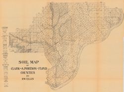
-
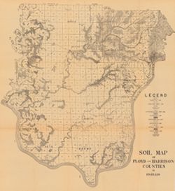
- Subject:
- Geographic Subject: Floyd County (Ind.), Geographic Subject: Harrison County (Ind.), and Topical Subject: Soils
- Creator:
- Ellis, R. W. (Robert W.)
- Publisher:
- Indiana. Department of Geology and Natural Resources
- Date Created:
- 1908
- Identifier:
- VAC3073-M-00741
- Genre:
- Thematic maps
- Geographic Location:
- Coordinates: W0861947 W0854538 N0382521 N0375728
- Related URL:
- Catalog URL: https://iucat.iu.edu/catalog/16096031
- Abstract:
- Detached from: A soil survey of Clark, Floyd, and Harrison counties / Robert W. Ellis. In Indiana Department of Geology and Natural Resources thirty-second a...
- Call Number:
- G4093.F5J3 1907 .E4
- Caption:
- Imprint: [Indianapolis] : [Indiana Department of Geology and Natural Resources], 1908
- Physical Description:
- Scale: Approximately 1:95,000 and Dimensions: 64 x 59 cm
- Alternate Identifier:
- Title Control Number: a16096031 and Alternate ID: 390726IP
- Persistent URL:
- https://purl.dlib.indiana.edu/iudl/images/VAC3073/VAC3073-M-00741
- Provenance:
- 32nd Annual Report (1907) / Indiana. Department of Geology and Natural Resources.
-
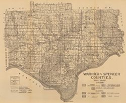
- Subject:
- Geographic Subject: Spencer County (Ind.), Geographic Subject: Warrick County (Ind.), and Topical Subject: Soils
- Creator:
- Shannon, C. W. (Charles William), 1879-1934
- Publisher:
- Indiana. Department of Geology and Natural Resources
- Date Created:
- 1910
- Identifier:
- VAC3073-M-00654
- Genre:
- Thematic maps
- Geographic Location:
- Coordinates: W0872823 W0864559 N0381446 N0374653
- Related URL:
- Catalog URL: https://iucat.iu.edu/catalog/16123910
- Abstract:
- Shows public roads and railroads. Detached from: A soil survey of Vanderburgh, Gibson, and Pike, and parts of Warrick and Spencer counties / Chas. W. Shan...
- Call Number:
- G4093.S5J3 1909 .S5
- Caption:
- Imprint: [Indianapolis] : [Indiana Department of Geology and Natural Resources], [1910]
- Physical Description:
- Dimensions: 44 x 52 cm and Scale: Approximately 1:126,720
- Alternate Identifier:
- Title Control Number: a16123910 and Alternate ID: 390726IP
- Persistent URL:
- https://purl.dlib.indiana.edu/iudl/images/VAC3073/VAC3073-M-00654
- Provenance:
- 34th Annual Report (1909) / Indiana. Department of Geology and Natural Resources.
-
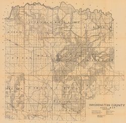
- Subject:
- Geographic Subject: Washington County (Ind.) and Topical Subject: Soils
- Creator:
- Indiana. Department of Geology and Natural Resources
- Publisher:
- Indiana. Department of Geology and Natural Resources
- Date Created:
- 1908
- Identifier:
- VAC3073-M-00603
- Genre:
- Thematic maps
- Geographic Location:
- Coordinates: W0861836 W0855051 N0384700 N0382504
- Related URL:
- Catalog URL: https://iucat.iu.edu/catalog/16096233
- Abstract:
- Shows railroads, dirt roads, improved roads, school houses, and churches. Detached from: Soil survey of Monroe, Brown, Lawrence, Martin, Orange, Washingto...
- Call Number:
- G4093.W5J3 1907 .I53
- Caption:
- Imprint: [Indianapolis] : [Indiana Department of Geology and Natural Resources], [1908]
- Physical Description:
- Scale: Approximately 1:63,360 and Dimensions: 67 x 68 cm
- Alternate Identifier:
- Title Control Number: a16096233 and Alternate ID: 390726IP
- Persistent URL:
- https://purl.dlib.indiana.edu/iudl/images/VAC3073/VAC3073-M-00603
- Provenance:
- 32nd Annual Report (1907) / Indiana. Department of Geology and Natural Resources.
-
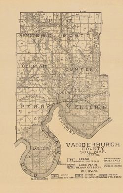
- Subject:
- Topical Subject: Soils and Geographic Subject: Vanderburgh County (Ind.)
- Creator:
- Shannon, C. W. (Charles William), 1879-1934
- Publisher:
- Indiana. Department of Geology and Natural Resources
- Date Created:
- 1910
- Identifier:
- VAC3073-M-00292
- Genre:
- Thematic maps
- Geographic Location:
- Coordinates: W0874202 W0872657 N0381006 N0374932
- Related URL:
- Catalog URL: https://iucat.iu.edu/catalog/16123565
- Abstract:
- Shows railroads and public roads. Detached from: A soil survey of Vanderburgh, Gibson, and Pike, and parts of Warrick and Spencer counties / Chas. W. Shan...
- Call Number:
- G4093.V3J3 1909 .S5
- Caption:
- Imprint: [Indianapolis] : [Indiana Department of Geology and Natural Resources], [1910]
- Physical Description:
- Dimensions: 37 x 24 cm and Scale: Approximately 1:126,720
- Alternate Identifier:
- Alternate ID: 390726IP and Title Control Number: a16123565
- Persistent URL:
- https://purl.dlib.indiana.edu/iudl/images/VAC3073/VAC3073-M-00292
- Provenance:
- 34th Annual Report (1909) / Indiana. Department of Geology and Natural Resources.
-
- Subject:
- Topical Subject: Soils, Geographic Subject: Clark County (Ind.), and Geographic Subject: Floyd County (Ind.)
- Creator:
- Ellis, R. W. (Robert W.)
- Publisher:
- Indiana. Department of Geology and Natural Resources
- Date Created:
- 1908
- Identifier:
- VAC3073-M-00249
- Genre:
- Thematic maps
- Geographic Location:
- Coordinates: W0855940 W0852455 N0383624 N0381601
- Related URL:
- Catalog URL: https://iucat.iu.edu/catalog/16152110
- Abstract:
- Detached from: A soil survey of Clark, Floyd, and Harrison counties / Robert W. Ellis. In Indiana Department of Geology and Natural Resources thirty-second a...
- Call Number:
- G4093.C4J3 1907 .E4
- Caption:
- Imprint: [Indianapolis] : [Indiana Department of Geology and Natural Resources], [1908]
- Physical Description:
- Dimensions: 49 x 64 cm and Scale: Approximately 1:90,000
- Alternate Identifier:
- Title Control Number: a16152110 and Alternate ID: 390726IP
- Persistent URL:
- https://purl.dlib.indiana.edu/iudl/images/VAC3073/VAC3073-M-00249
- Provenance:
- 32nd Annual Report (1907) / Indiana. Department of Geology and Natural Resources.
-
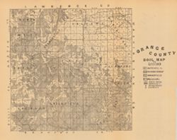
- Subject:
- Geographic Subject: Orange County (Ind.) and Topical Subject: Soils
- Creator:
- Indiana. Department of Geology and Natural Resources
- Publisher:
- Indiana. Department of Geology and Natural Resources
- Date Created:
- 1908
- Identifier:
- VAC3073-M-00221
- Genre:
- Thematic maps
- Geographic Location:
- Coordinates: W0864059 W0861827 N0384119 N0382346
- Related URL:
- Catalog URL: https://iucat.iu.edu/catalog/16095946
- Abstract:
- Detached from: A soil survey of Monroe, Brown, Lawrence, Martin, Orange, Washington and Jackson counties / by Chas. W. Shannon and L. C. Snider. In Indiana D...
- Call Number:
- G4093.O6J3 1907 .I53
- Caption:
- Imprint: [Indianapolis] : [Indiana Department of Geology and Natural Resources], [1908]
- Physical Description:
- Dimensions: 27 x 27 cm and Scale: Approximately 1:126,720
- Alternate Identifier:
- Title Control Number: a16095946 and Alternate ID: 390726IP
- Persistent URL:
- https://purl.dlib.indiana.edu/iudl/images/VAC3073/VAC3073-M-00221
- Provenance:
- 32nd Annual Report (1907) / Indiana. Department of Geology and Natural Resources.
-
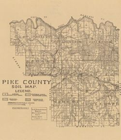
- Subject:
- Geographic Subject: Pike County (Ind.) and Topical Subject: Soils
- Creator:
- Shannon, M. E. and Shannon, C. W. (Charles William), 1879-1934
- Publisher:
- Indiana. Department of Geology and Natural Resources
- Date Created:
- 1910
- Identifier:
- VAC3073-M-00173
- Genre:
- Thematic maps
- Geographic Location:
- Coordinates: W0872746 W0870419 N0383308 N0381351
- Related URL:
- Catalog URL: https://iucat.iu.edu/catalog/16123837
- Abstract:
- Shows railroads and 3 classes of roads. "U.S. topographic sheets, state geological maps, field work 1909." Detached from: A soil survey of Vande...
- Call Number:
- G4093.P4J3 1909 .S5
- Caption:
- Imprint: [Indianapolis] : [Indiana Department of Geology and Natural Resources], [1910]
- Physical Description:
- Scale: Approximately 1:126,720 and Dimensions: 37 x 32 cm
- Alternate Identifier:
- Title Control Number: a16123837 and Alternate ID: 390726IP
- Persistent URL:
- https://purl.dlib.indiana.edu/iudl/images/VAC3073/VAC3073-M-00173
- Provenance:
- 34th Annual Report (1909) / Indiana. Department of Geology and Natural Resources.
-
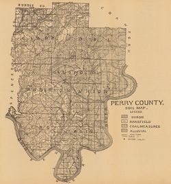
- Subject:
- Geographic Subject: Perry County (Ind.) and Topical Subject: Soils
- Creator:
- Indiana. Department of Geology and Natural Resources
- Publisher:
- Indiana. Department of Geology and Natural Resources
- Date Created:
- 1909
- Identifier:
- VAC3073-M-00164
- Genre:
- Thematic maps
- Geographic Location:
- Coordinates: W0864853 W0862548 N0381558 N0375029
- Related URL:
- Catalog URL: https://iucat.iu.edu/catalog/16123915
- Abstract:
- Shows school houses, public roads, and railroads. Detached from: A soil survey of four counties of southern Indiana / Chas. W. Shannon and L.C. Snider. In...
- Call Number:
- G4093.P3J3 1908 .I53
- Caption:
- Imprint: [Indianapolis] : [Indiana Department of Geology and Natural Resources], [1909]
- Physical Description:
- Dimensions: 41 x 38 cm and Scale: Approximately 1:126,720
- Alternate Identifier:
- Alternate ID: 390726IP and Title Control Number: a16123915
- Persistent URL:
- https://purl.dlib.indiana.edu/iudl/images/VAC3073/VAC3073-M-00164
- Provenance:
- 33rd Annual Report (1908) / Indiana. Department of Geology and Natural Resources.
-
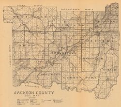
- Subject:
- Geographic Subject: Jackson County (Ind.) and Topical Subject: Soils
- Creator:
- Indiana. Department of Geology and Natural Resources
- Publisher:
- Indiana. Department of Geology and Natural Resources
- Date Created:
- 1908
- Identifier:
- VAC3073-M-00057
- Genre:
- Thematic maps
- Geographic Location:
- Coordinates: W0861905 W0854742 N0390416 N0384330
- Related URL:
- Catalog URL: https://iucat.iu.edu/catalog/16151891
- Abstract:
- Shows dirt roads, improved roads, railroads, school houses, and churches. Detached from: Soil survey of Monroe, Brown, Lawrence, Martin, Orange, Washingto...
- Call Number:
- G4093.J2J3 1907 .J3
- Caption:
- Imprint: [Indianapolis] : [Indiana. Department of Geology and Natural Resources], [1908]
- Physical Description:
- Dimensions: 35 x 39 cm and Scale: Approximately 1:126,720
- Alternate Identifier:
- Title Control Number: a16151891 and Alternate ID: 390726IP
- Persistent URL:
- https://purl.dlib.indiana.edu/iudl/images/VAC3073/VAC3073-M-00057
- Provenance:
- 32nd Annual Report (1907) / Indiana. Department of Geology and Natural Resources.
-
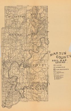
- Subject:
- Topical Subject: Soils and Geographic Subject: Martin County (Ind.)
- Creator:
- Indiana. Department of Geology and Natural Resources
- Publisher:
- Indiana. Department of Geology and Natural Resources
- Date Created:
- 1908
- Identifier:
- VAC3073-M-00035
- Genre:
- Thematic maps
- Geographic Location:
- Coordinates: W0865527 W0864056 N0385416 N0382941
- Related URL:
- Catalog URL: https://iucat.iu.edu/catalog/16095827
- Abstract:
- Shows dirt roads and improved roads, school houses, churches, and stores. Detached from: Soil survey of Monroe, Brown, Lawrence, Martin, Orange, Washingto...
- Call Number:
- G4093.M5J3 1907 .I53
- Caption:
- Imprint: [Indianapolis] : [Indiana Department of Geology and Natural Resources], [1908]
- Physical Description:
- Scale: Approximately 1:126,720 and Dimensions: 40 x 27 cm
- Alternate Identifier:
- Alternate ID: 390726IP and Title Control Number: a16095827
- Persistent URL:
- https://purl.dlib.indiana.edu/iudl/images/VAC3073/VAC3073-M-00035
- Provenance:
- 32nd Annual Report (1907) / Indiana. Department of Geology and Natural Resources.
