
Search Constraints
You searched for:
Country
СССР (USSR)
Remove constraint Country: СССР (USSR)
Publisher
Главное управление государственной съемки и картографии НКВД СССР
Remove constraint Publisher: Главное управление государственной съемки и картографии НКВД СССР
1 - 75 of 75
Search Results
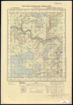
-
- Description:
- 1938
- Subject:
- Geographic Subject: Vyshitino, Topical Subject: Soviet Union, and Topical Subject: Maps
- Publisher:
- Главное управление государственной съемки и картографии НКВД СССР
- Language:
- Russian
- Identifier:
- VAC9619-003534
- Genre:
- Topographic Maps and Military Maps
- Geographic Location:
- Coordinates: 57.3333, 31.75, 57.5, 32.0
- Related URL:
- Catalog URL: http://iucat.iu.edu/catalog/5020131 and Download GeoTIFF: https://drive.google.com/file/d/15fYzUgb8nygu04vteSGvdZHPizVqeb0h/view?usp=sharing
- Abstract:
- Modern area represented: Вышитино (Vyshitino), Novgorodskaya oblast, Russia
- Call Number:
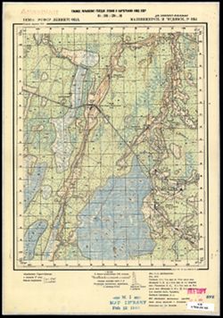
- GM G7000 s50 .S68 sheet O-36-88-D
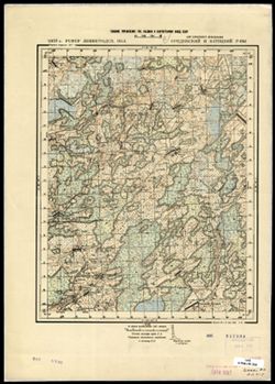
- Caption:
- Captured map
- City:
- Вышитино (Vyshitino)
- Copyright Holder:
- No Copyright - United States
- Country:
- СССР (USSR)
- State/Province:
- Ленинградская область (Leningrad oblast), Молвотицкий район (Molvotitsky district), and Залучский район (Zaluchsky district)
- Physical Description:
- Scale: 1:50,000
- Persistent URL:
- http://purl.dlib.indiana.edu/iudl/images/VAC9619/VAC9619-003534
- Provenance:
- DMA Topographic Center, Army Map Service Library, OMAHA, Library of Congress Geography & Map Division
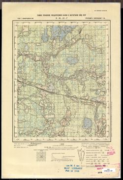
-
- Description:
- 1938
- Subject:
- Topical Subject: Maps, Geographic Subject: Konakovo, and Topical Subject: Soviet Union
- Publisher:
- Главное управление государственной съемки и картографии НКВД СССР
- Language:
- Russian
- Date Created:
- 1941
- Identifier:
- VAC9619-003522
- Genre:
- Topographic Maps and Military Maps
- Geographic Location:
- Coordinates: 56.667, 36.75, 56.833, 37
- Related URL:
- Download GeoTIFF: https://drive.google.com/file/d/113GolZU0LWI5CWw31Rws39j5ikise7Gi/view?usp=sharing and Catalog URL: http://iucat.iu.edu/catalog/5020131
- Abstract:
- Modern area represented: Конаково (Konakovo), Tverskaya oblast, Russia
- Call Number:
- GM G7000 s50 .S68 sheet O-37-110-D
- City:
- Конаково (Konakovo)
- Copyright Holder:
- No Copyright - United States
- Country:
- СССР (USSR)
- State/Province:
- Калининская область (Kalinin oblast), Оршинский район (Orshinsky district), Конаковский район (Konakovsky district), and Кимрский район (Kimrsky district)
- Physical Description:
- Scale: 1:50,000
- Persistent URL:
- http://purl.dlib.indiana.edu/iudl/images/VAC9619/VAC9619-003522
- Provenance:
- DMA Topographic Center, Army Map Service Library, OMAHA, Library of Congress Geography & Map Division
-
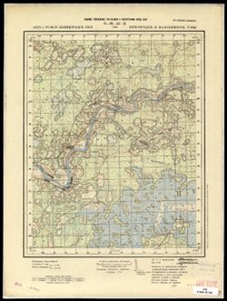
- Description:
- 1938
- Subject:
- Topical Subject: Soviet Union, Geographic Subject: Kruttsy, and Topical Subject: Maps
- Publisher:
- Главное управление государственной съемки и картографии НКВД СССР
- Language:
- Russian
- Date Created:
- 1941
- Identifier:
- VAC9619-003475
- Genre:
- Military Maps and Topographic Maps
- Geographic Location:
- Coordinates: 56.5, 34.5, 56.667, 34.75
- Related URL:
- Catalog URL: http://iucat.iu.edu/catalog/5020131 and Download GeoTIFF: https://drive.google.com/file/d/1cihOLqbhj-Kp4lrE_tjxKT5oBYLDHFNp/view?usp=sharing
- Abstract:
- Modern area represented: Kruttsy, Tver oblast, Russia
- Call Number:
- G7000 s50 .S68 sheet O-36-130-A
- City:
- Крутцы (Kruttsy)
- Copyright Holder:
- No Copyright - United States
- Country:
- СССР (USSR)
- State/Province:
- Старицкий район (Staritsky district), Калининская область (Kalinin oblast), Луковниковский район (Lukovnikovsky district), Высоковский район (Vysokovsky dist...
- Physical Description:
- Scale: 1:50,000
- Persistent URL:
- http://purl.dlib.indiana.edu/iudl/images/VAC9619/VAC9619-003475
- Provenance:
- DMA Topographic Center, Army Map Service Library, OMAHA, Library of Congress Geography & Map Division
-
- Description:
- 1938
- Subject:
- Topical Subject: Maps, Geographic Subject: Zaytsevo, and Topical Subject: Soviet Union
- Publisher:
- Главное управление государственной съемки и картографии НКВД СССР
- Language:
- Russian
- Identifier:
- VAC9619-003372
- Genre:
- Topographic Maps and Military Maps
- Geographic Location:
- Coordinates: 58.333, 32, 58.5, 32.25
- Related URL:
- Catalog URL: http://iucat.iu.edu/catalog/5020131 and Download GeoTIFF: https://drive.google.com/file/d/1K7qE21hkq2ReYNYXblrWOZeFfyL59Z1D/view?usp=sharing
- Abstract:
- Modern area represented: Дворищи (Dvorishchi), Novgorodskaya oblast, Russia
- Call Number:
- G7000 s50 .S68 sheet O-36-53-C
- Caption:
- Для служебного пользования
- City:
- Зайцево (Zaytsevo)
- Copyright Holder:
- No Copyright - United States
- Country:
- СССР (USSR)
- State/Province:
- Крестецкий район (Krestetsky district), Новгородский район (Novgorod district), and Ленинградская область (Leningrad oblast)
- Physical Description:
- Scale: 1:50,000
- Persistent URL:
- http://purl.dlib.indiana.edu/iudl/images/VAC9619/VAC9619-003372
- Provenance:
- Army Map Service Library, OMAHA, Library of Congress Geography & Map Division
-
- Description:
- 1938
- Subject:
- Topical Subject: Soviet Union, Geographic Subject: Devkino, and Topical Subject: Maps
- Publisher:
- Главное управление государственной съемки и картографии НКВД СССР
- Language:
- Russian
- Identifier:
- VAC9619-003370
- Genre:
- Military Maps and Topographic Maps
- Geographic Location:
- Coordinates: 58.5, 32, 58.667, 32.25
- Related URL:
- Catalog URL: http://iucat.iu.edu/catalog/5020131 and Download GeoTIFF: https://drive.google.com/file/d/1K-lk3plzKwkzJPOvkW9iMufZRDqPaBNr/view?usp=sharing
- Abstract:
- Modern area represented: Девкино (Devkino), Novgorodskaya oblast, Russia
- Call Number:
- G7000 s50 .S68 sheet O-36-53-A
- Caption:
- Для служебного пользования
- City:
- Девкино (Devkino)
- Copyright Holder:
- No Copyright - United States
- Country:
- СССР (USSR)
- State/Province:
- Новгородский район (Novgorod district), Ленинградская область (Leningrad oblast), Маловишерский район (Malovishersky district), and Крестецкий район (Krestet...
- Physical Description:
- Scale: 1:50,000
- Persistent URL:
- http://purl.dlib.indiana.edu/iudl/images/VAC9619/VAC9619-003370
- Provenance:
- CIA Map Branch -- Received
-
- Description:
- 1938
- Subject:
- Topical Subject: Soviet Union, Geographic Subject: Krasnyye Stanki, and Topical Subject: Maps
- Publisher:
- Главное управление государственной съемки и картографии НКВД СССР
- Language:
- Russian
- Identifier:
- VAC9619-003369
- Genre:
- Military Maps and Topographic Maps
- Geographic Location:
- Coordinates: 58.333, 31.75, 58.5, 32
- Related URL:
- Catalog URL: http://iucat.iu.edu/catalog/5020131 and Download GeoTIFF: https://drive.google.com/file/d/1wW7qF7R81RNq_wPLkVNQc2tuueM2oPrI/view?usp=sharing
- Abstract:
- Modern area represented: Красные Станки (Krasnyye Stanki), Novgorodskaya oblast, Russia
- Call Number:
- G7000 s50 .S68 sheet O-36-52-D
- Caption:
- Для служебного пользования
- City:
- Красные Станки (Krasnyye Stanki)
- Copyright Holder:
- No Copyright - United States
- Country:
- СССР (USSR)
- State/Province:
- Ленинградская область (Leningrad oblast), Новгородский район (Novgorod district), and Крестецкий район (Krestetsky district)
- Physical Description:
- Scale: 1:50,000
- Persistent URL:
- http://purl.dlib.indiana.edu/iudl/images/VAC9619/VAC9619-003369
- Provenance:
- M. I. Map Library
-
- Description:
- 1937
- Subject:
- Topical Subject: Maps, Topical Subject: Soviet Union, and Geographic Subject: Proletariy
- Publisher:
- Главное управление государственной съемки и картографии НКВД СССР
- Language:
- Russian
- Identifier:
- VAC9619-003368
- Genre:
- Military Maps and Topographic Maps
- Geographic Location:
- Coordinates: 58.333, 31.5, 58.5, 31.75
- Related URL:
- Catalog URL: http://iucat.iu.edu/catalog/5020131 and Download GeoTIFF: https://drive.google.com/file/d/1HoQwgwLFHAlNPLb-BINjNfKyIBLypAFN/view?usp=sharing
- Abstract:
- Modern area represented: Пролетарий (Proletariy), Novgorodskaya oblast, Russia
- Call Number:
- G7000 s50 .S68 sheet O-36-52-C
- Caption:
- Captured map and Для служебного пользования
- City:
- Проолетарский (Proletarskiy)
- Copyright Holder:
- No Copyright - United States
- Country:
- СССР (USSR)
- State/Province:
- Новгородский район (Novgorod district), Ленинградская область (Leningrad oblast), and РСФСР (RSFSR)
- Physical Description:
- Scale: 1:50,000
- Persistent URL:
- http://purl.dlib.indiana.edu/iudl/images/VAC9619/VAC9619-003368
- Provenance:
- DMA Topographic Center, Army Map Service Library, OMAHA, Library of Congress Geography & Map Division
-
- Description:
- 1937
- Subject:
- Geographic Subject: Ryshevo, Topical Subject: Soviet Union, and Topical Subject: Maps
- Publisher:
- Главное управление государственной съемки и картографии НКВД СССР
- Language:
- Russian
- Identifier:
- VAC9619-003367
- Genre:
- Topographic Maps and Military Maps
- Geographic Location:
- Coordinates: 58.5, 31.75, 58.667, 32
- Related URL:
- Catalog URL: http://iucat.iu.edu/catalog/5020131 and Download GeoTIFF: https://drive.google.com/file/d/1FlRS6OId6KY5Vt-TkQLcWKJG6h0y81VJ/view?usp=sharing
- Abstract:
- Modern area represented: Рышево (Ryshevo), Novgorodskaya oblast, Russia
- Call Number:
- G7000 s50 .S68 sheet O-36-52-B
- Caption:
- Для служебного пользования
- City:
- Рышево (Ryshevo)
- Copyright Holder:
- No Copyright - United States
- Country:
- СССР (USSR)
- State/Province:
- Ленинградская область (Leningrad oblast), РСФСР (RSFSR), Новгородский район (Novgorod district), and Маловишерский район (Malovishersky district)
- Physical Description:
- Scale: 1:50,000
- Persistent URL:
- http://purl.dlib.indiana.edu/iudl/images/VAC9619/VAC9619-003367
- Provenance:
- CIA Map Branch -- Received
-
- Description:
- 1937
- Subject:
- Topical Subject: Soviet Union, Topical Subject: Maps, and Geographic Subject: Novoselitsy
- Publisher:
- Главное управление государственной съемки и картографии НКВД СССР
- Language:
- Russian
- Identifier:
- VAC9619-003366
- Genre:
- Military Maps and Topographic Maps
- Geographic Location:
- Coordinates: 58.5, 31.5, 58.667, 31.75
- Related URL:
- Download GeoTIFF: https://drive.google.com/file/d/1SMsFVcxVD-cB8ntfJUAq6HOEX6nTKmM8/view?usp=sharing and Catalog URL: http://iucat.iu.edu/catalog/5020131
- Abstract:
- Modern area represented: Новоселицы (Novoselitsy), Novgorodskaya oblast, Russia
- Call Number:
- G7000 s50 .S68 sheet O-36-52-A
- Caption:
- Для служебного пользования and Captured map
- City:
- Новоселицы (Novoselitsy)
- Copyright Holder:
- No Copyright - United States
- Country:
- СССР (USSR)
- State/Province:
- Ленинградская область (Leningrad oblast), РСФСР (RSFSR), and Новгородский район (Novgorod district)
- Physical Description:
- Scale: 1:50,000
- Persistent URL:
- http://purl.dlib.indiana.edu/iudl/images/VAC9619/VAC9619-003366
- Provenance:
- DMA Topographic Center, Army Map Service Library, OMAHA, Library of Congress Geography & Map Division
-
- Description:
- 1937
- Subject:
- Geographic Subject: Menyusha, Topical Subject: Maps, and Topical Subject: Soviet Union
- Publisher:
- Главное управление государственной съемки и картографии НКВД СССР
- Language:
- Russian
- Identifier:
- VAC9619-003364
- Genre:
- Topographic Maps and Military Maps
- Geographic Location:
- Coordinates: 58.333, 30.5, 58.5, 30.75
- Related URL:
- Catalog URL: http://iucat.iu.edu/catalog/5020131 and Download GeoTIFF: https://drive.google.com/file/d/1IDU8_lKnWcG2kljyRcctukOmFczGuoP5/view?usp=sharing
- Abstract:
- Modern area represented: Менюша (Menyusha), Novgorodskaya oblast, Russia
- Call Number:
- G7000 s50 .S68 sheet O-36-50-C
- Caption:
- Captured map and Для служебного пользования
- City:
- Менюши (Menyushi)
- Copyright Holder:
- No Copyright - United States
- Country:
- СССР (USSR)
- State/Province:
- РСФСР (RSFSR), Новгородский район (Novgorod district), Батецкий район (Batetsky district), Ленинградская область (Leningrad oblast), and Шимский район (Shims...
- Physical Description:
- Scale: 1:50,000
- Persistent URL:
- http://purl.dlib.indiana.edu/iudl/images/VAC9619/VAC9619-003364
- Provenance:
- DMA Topographic Center, Army Map Service Library, OMAHA, Library of Congress Geography & Map Division
-
- Description:
- 1937
- Subject:
- Geographic Subject: Ostrov, Topical Subject: Maps, and Topical Subject: Soviet Union
- Publisher:
- Главное управление государственной съемки и картографии НКВД СССР
- Language:
- Russian
- Identifier:
- VAC9619-003362
- Genre:
- Military Maps and Topographic Maps
- Geographic Location:
- Coordinates: 58.5, 30.5, 58.667, 30.75
- Related URL:
- Download GeoTIFF: https://drive.google.com/file/d/13LX8EyiqOj0sl16DafCY3HH7ggfcsfqX/view?usp=sharing and Catalog URL: http://iucat.iu.edu/catalog/5020131
- Abstract:
- Modern area represented: Остров (Ostrov), Novgorodskaya oblast, Russia
- Call Number:
- G7000 s50 .S68 sheet O-36-50-A
- Caption:
- Для служебного пользования
- City:
- Остров (Ostrov)
- Copyright Holder:
- No Copyright - United States
- Country:
- СССР (USSR)
- State/Province:
- Батецкий район (Batetsky district), Ленинградская область (Leningrad oblast), РСФСР (RSFSR), and Новгородский район (Novgorod district)
- Physical Description:
- Scale: 1:50,000
- Persistent URL:
- http://purl.dlib.indiana.edu/iudl/images/VAC9619/VAC9619-003362
- Provenance:
- Army Map Service Library, OMAHA, Library of Congress Geography & Map Division
-
- Description:
- 1936
- Subject:
- Topical Subject: Maps, Topical Subject: Soviet Union, and Geographic Subject: Vislenev Ostrov
- Publisher:
- Главное управление государственной съемки и картографии НКВД СССР
- Language:
- Russian
- Date Created:
- 1940
- Identifier:
- VAC9619-003357
- Genre:
- Topographic Maps and Military Maps
- Geographic Location:
- Coordinates: 58.667, 33, 58.833, 33.25
- Related URL:
- Download GeoTIFF: https://drive.google.com/file/d/1Z4KKNMmjDWJB81vwke4io5iBRL4zez_d/view?usp=sharing and Catalog URL: http://iucat.iu.edu/catalog/5020131
- Abstract:
- Modern area represented: Висленев Остров (Vislenev Ostrov), Novgorodskaya oblast, Russia
- Call Number:
- G7000 s50 .S68 sheet O-36-43-C
- Caption:
- Для служебного пользования
- City:
- Висленев Остров (Vislenev Ostrov)
- Copyright Holder:
- No Copyright - United States
- Country:
- СССР (USSR)
- State/Province:
- Любытинский район (Lyubytinsky district), РСФСР (RSFSR), Ленинградская область (Leningrad oblast), Окуловский район (Okulovsky district), and Маловишерский р...
- Physical Description:
- Scale: 1:50,000
- Persistent URL:
- http://purl.dlib.indiana.edu/iudl/images/VAC9619/VAC9619-003357
- Provenance:
- DMA Topographic Center, Army Map Service Library, OMAHA, Library of Congress Geography & Map Division
-
- Description:
- 1936
- Subject:
- Topical Subject: Soviet Union, Geographic Subject: Vitin Bor, and Topical Subject: Maps
- Publisher:
- Главное управление государственной съемки и картографии НКВД СССР
- Language:
- Russian
- Identifier:
- VAC9619-003356
- Genre:
- Military Maps and Topographic Maps
- Geographic Location:
- Coordinates: 58.833, 33.25, 59, 33.5
- Related URL:
- Catalog URL: http://iucat.iu.edu/catalog/5020131 and Download GeoTIFF: https://drive.google.com/file/d/1ADMB13mSwRY5xkvUguS1T0Ij0tzXqWGn/view?usp=sharing
- Abstract:
- Modern area represented: Витин Бор (Vitin Bor), Novgorodskaya oblast, Russia
- Call Number:
- G7000 s50 .S68 sheet O-36-43-B
- Caption:
- Для служебного пользования
- City:
- Витин Бор (Vitin Bor)
- Copyright Holder:
- No Copyright - United States
- Country:
- СССР (USSR)
- State/Province:
- Дрегельский район (Dregelsky district), Ленинградская область (Leningrad oblast), РСФСР (RSFSR), and Любытинский район (Lyubytinsky district)
- Physical Description:
- Scale: 1:50,000
- Persistent URL:
- http://purl.dlib.indiana.edu/iudl/images/VAC9619/VAC9619-003356
- Provenance:
- DMA Topographic Center, Army Map Service Library, OMAHA
-
- Description:
- 1936
- Subject:
- Topical Subject: Soviet Union, Topical Subject: Maps, and Geographic Subject: Pelyushnya
- Publisher:
- Главное управление государственной съемки и картографии НКВД СССР
- Language:
- Russian
- Identifier:
- VAC9619-003355
- Genre:
- Topographic Maps and Military Maps
- Geographic Location:
- Coordinates: 58.833, 32.75, 59, 33
- Related URL:
- Catalog URL: http://iucat.iu.edu/catalog/5020131 and Download GeoTIFF: https://drive.google.com/file/d/1-3dVnnFQfMt2k6ae3LHTY0YOdThFupQQ/view?usp=sharing
- Abstract:
- Modern area represented: Пелюшня (Pelyushnya), Novgorodskaya oblast, Russia
- Call Number:
- G7000 s50 .S68 sheet O-36-42-B
- Caption:
- Captured map and Для служебного пользования
- City:
- Пелюшня (Pelyushnya)
- Copyright Holder:
- No Copyright - United States
- Country:
- СССР (USSR)
- State/Province:
- РСФСР (RSFSR), Ленинградская область (Leningrad oblast), Маловишерский район (Malovishersky district), and Дрегельский район (Dregelsky district)
- Physical Description:
- Scale: 1:50,000
- Persistent URL:
- http://purl.dlib.indiana.edu/iudl/images/VAC9619/VAC9619-003355
- Provenance:
- DMA Topographic Center, Army Map Service Library, OMAHA, Library of Congress Geography & Map Division
-
- Description:
- 1936
- Subject:
- Topical Subject: Maps, Geographic Subject: Fal’kovo, and Topical Subject: Soviet Union
- Publisher:
- Главное управление государственной съемки и картографии НКВД СССР
- Language:
- Russian
- Date Created:
- 1940
- Identifier:
- VAC9619-003354
- Genre:
- Topographic Maps and Military Maps
- Geographic Location:
- Coordinates: 58.833, 32.5, 59, 32.75
- Related URL:
- Catalog URL: http://iucat.iu.edu/catalog/5020131 and Download GeoTIFF: https://drive.google.com/file/d/1W07zpn13vURq4KexJogva1YoMnX0SMwZ/view?usp=sharing
- Abstract:
- Modern area represented: Фальково (Fal’kovo), Novgorodskaya oblast, Russia
- Call Number:
- G7000 s50 .S68 sheet O-36-42-A
- Caption:
- Для служебного пользования and Captured map
- City:
- Фальково (Fal’kovo)
- Copyright Holder:
- No Copyright - United States
- Country:
- СССР (USSR)
- State/Province:
- Маловишерский район (Malovishersky district), Ленинградская область (Leningrad oblast), and РСФСР (RSFSR)
- Physical Description:
- Scale: 1:50,000
- Persistent URL:
- http://purl.dlib.indiana.edu/iudl/images/VAC9619/VAC9619-003354
- Provenance:
- DMA Topographic Center, Army Map Service Library, OMAHA, Library of Congress Geography & Map Division
-
- Description:
- 1936
- Subject:
- Topical Subject: Soviet Union, Topical Subject: Maps, and Geographic Subject: Glutno
- Publisher:
- Главное управление государственной съемки и картографии НКВД СССР
- Language:
- Russian
- Date Created:
- 1941
- Identifier:
- VAC9619-003352
- Genre:
- Military Maps and Topographic Maps
- Geographic Location:
- Coordinates: 58.667, 32, 58.833, 32.25
- Related URL:
- Download GeoTIFF: https://drive.google.com/file/d/1--cVDDhZJZlZhbOr4z4CmcrTGL8dblq0/view?usp=sharing and Catalog URL: http://iucat.iu.edu/catalog/5020131
- Abstract:
- Modern area represented: Глутно (Glutno), Novgorodskaya oblast, Russia
- Call Number:
- G7000 s50 .S68 sheet O-36-41-C
- Caption:
- Для служебного пользования and Captured map
- City:
- Глутно (Glutno)
- Copyright Holder:
- No Copyright - United States
- Country:
- СССР (USSR)
- State/Province:
- Маловишерский район (Malovishersky district), РСФСР (RSFSR), and Ленинградская область (Leningrad oblast)
- Physical Description:
- Scale: 1:50,000
- Persistent URL:
- http://purl.dlib.indiana.edu/iudl/images/VAC9619/VAC9619-003352
- Provenance:
- Army Map Service Library, OMAHA, Library of Congress Geography & Map Division
-
- Description:
- 1936
- Subject:
- Topical Subject: Soviet Union, Topical Subject: Maps, and Geographic Subject: Burga
- Publisher:
- Главное управление государственной съемки и картографии НКВД СССР
- Language:
- Russian
- Date Created:
- 1941
- Identifier:
- VAC9619-003353
- Genre:
- Military Maps and Topographic Maps
- Geographic Location:
- Coordinates: 58.667, 32.25, 58.833, 32.5
- Related URL:
- Download GeoTIFF: https://drive.google.com/file/d/1jDFXLd8FB4_pZaY0B9_cVM1Zh4ibtoky/view?usp=sharing and Catalog URL: http://iucat.iu.edu/catalog/5020131
- Abstract:
- Modern area represented: Бурга (Burga), Novgorodskaya oblast, Russia
- Call Number:
- G7000 s50 .S68 sheet O-36-41-D
- Caption:
- Captured map and Для служебного пользования
- City:
- Бурга (Burga)
- Copyright Holder:
- No Copyright - United States
- Country:
- СССР (USSR)
- State/Province:
- РСФСР (RSFSR), Ленинградская область (Leningrad oblast), and Маловишерский район (Malovishersky district)
- Physical Description:
- Scale: 1:50,000
- Persistent URL:
- http://purl.dlib.indiana.edu/iudl/images/VAC9619/VAC9619-003353
- Provenance:
- Army Map Service Library, OMAHA, Library of Congress Geography & Map Division
-
- Description:
- 1936
- Subject:
- Topical Subject: Maps, Geographic Subject: Pustaya Visherka, and Topical Subject: Soviet Union
- Publisher:
- Главное управление государственной съемки и картографии НКВД СССР
- Language:
- Russian
- Date Created:
- 1941
- Identifier:
- VAC9619-003351
- Genre:
- Military Maps and Topographic Maps
- Geographic Location:
- Coordinates: 58.833, 32.25, 59, 32.5
- Related URL:
- Catalog URL: http://iucat.iu.edu/catalog/5020131 and Download GeoTIFF: https://drive.google.com/file/d/1HAbz9xPIPMxBjtR5SOgZydbei2skVOnc/view?usp=sharing
- Abstract:
- Modern area represented: Пустая Вишерка (Pustaya Visherka), Novgorodskaya oblast, Russia
- Call Number:
- G7000 s50 .S68 sheet O-36-41-B
- Caption:
- Captured map and Для служебного пользования
- City:
- Пустая Вишерка (Pustaya Visherka)
- Copyright Holder:
- No Copyright - United States
- Country:
- СССР (USSR)
- State/Province:
- Ленинградская область (Leningrad oblast), Маловишерский район (Malovishersky district), and РСФСР (RSFSR)
- Physical Description:
- Scale: 1:50,000
- Persistent URL:
- http://purl.dlib.indiana.edu/iudl/images/VAC9619/VAC9619-003351
- Provenance:
- Army Map Service Library, OMAHA, Library of Congress Geography & Map Division
-
- Description:
- 1936
- Subject:
- Topical Subject: Soviet Union, Topical Subject: Maps, and Geographic Subject: Malaya Vishera
- Publisher:
- Главное управление государственной съемки и картографии НКВД СССР
- Language:
- Russian
- Identifier:
- VAC9619-003350
- Genre:
- Topographic Maps and Military Maps
- Geographic Location:
- Coordinates: 58.833, 32, 59, 32.5
- Related URL:
- Download GeoTIFF: https://drive.google.com/file/d/19OcoQTcV8eztvmEiXoB2RPdQVCXjOEdb/view?usp=sharing, https://drive.google.com/file/d/1pVPSsHe_4PQ8BEFhFJwwTy...
- Abstract:
- Modern area represented: Малая Вишера (Malaya Vishera), Novgorodskaya oblast, Russia
- Call Number:
- G7000 s50 .S68 sheet O-36-41-A
- Caption:
- Для служебного пользования and Captured map
- City:
- Малая Вишера (Malaya Vishera)
- Copyright Holder:
- No Copyright - United States
- Country:
- СССР (USSR)
- State/Province:
- Маловишерский район (Malovishersky district), Ленинградская область (Leningrad oblast), and РСФСР (RSFSR)
- Physical Description:
- Scale: 1:50,000
- Persistent URL:
- http://purl.dlib.indiana.edu/iudl/images/VAC9619/VAC9619-003350
- Provenance:
- Army Map Service Library, OMAHA, Library of Congress Geography & Map Division
-
- Description:
- 1937
- Subject:
- Topical Subject: Soviet Union, Geographic Subject: Radocha, and Topical Subject: Maps
- Publisher:
- Главное управление государственной съемки и картографии НКВД СССР
- Language:
- Russian
- Identifier:
- VAC9619-003349
- Genre:
- Military Maps and Topographic Maps
- Geographic Location:
- Coordinates: 58.667, 31.75, 58.833, 32
- Related URL:
- Download GeoTIFF: https://drive.google.com/file/d/1ZNHMDAQawaHv8k6lAQzvW3K6VJoZr6nP/view?usp=sharing and Catalog URL: http://iucat.iu.edu/catalog/5020131
- Abstract:
- Modern area represented: Радоча (Radocha), Novgorodskaya oblast, Russia
- Call Number:
- G7000 s50 .S68 sheet O-36-40-D
- Caption:
- Для служебного пользования
- City:
- Радоча (Radocha)
- Copyright Holder:
- No Copyright - United States
- Country:
- СССР (USSR)
- State/Province:
- Новгородский район (Novgorod district), Ленинградская область (Leningrad oblast), Чудовский район (Chudovsky district), Маловишерский район (Malovishersky di...
- Physical Description:
- Scale: 1:50,000
- Persistent URL:
- http://purl.dlib.indiana.edu/iudl/images/VAC9619/VAC9619-003349
- Provenance:
- Army Map Service Library, Library of Congress Geography & Map Division
-
- Description:
- 1937
- Subject:
- Topical Subject: Soviet Union, Topical Subject: Maps, and Geographic Subject: Zmeysko
- Publisher:
- Главное управление государственной съемки и картографии НКВД СССР
- Language:
- Russian
- Identifier:
- VAC9619-003348
- Genre:
- Military Maps and Topographic Maps
- Geographic Location:
- Coordinates: 58.667, 31.5, 58.833, 31.75
- Related URL:
- Catalog URL: http://iucat.iu.edu/catalog/5020131 and Download GeoTIFF: https://drive.google.com/file/d/1IFYKlcOAa_b1GOxpf2u48o3WUyKFSiEw/view?usp=sharing
- Abstract:
- Modern area represented: Змейско (Zmeysko), Novgorodskaya oblast, Russia
- Call Number:
- G7000 s50 .S68 sheet O-36-40-C
- Caption:
- Для служебного пользования
- City:
- Змейско (Zmeysko)
- Copyright Holder:
- No Copyright - United States
- Country:
- СССР (USSR)
- State/Province:
- Ленинградская область (Leningrad oblast), Новгородский район (Novgorod district), Маловишерский район (Malovishersky district), and РСФСР (RSFSR)
- Physical Description:
- Scale: 1:50,000
- Persistent URL:
- http://purl.dlib.indiana.edu/iudl/images/VAC9619/VAC9619-003348
- Provenance:
- Army Map Service Library, OMAHA, Library of Congress Geography & Map Division
-
- Description:
- 1937
- Subject:
- Geographic Subject: Gryady, Topical Subject: Soviet Union, and Topical Subject: Maps
- Publisher:
- Главное управление государственной съемки и картографии НКВД СССР
- Language:
- Russian
- Date Created:
- 1941
- Identifier:
- VAC9619-003347
- Genre:
- Military Maps and Topographic Maps
- Geographic Location:
- Coordinates: 58.8333, 31.75, 59.0, 32.0
- Related URL:
- Catalog URL: http://iucat.iu.edu/catalog/5020131 and Download GeoTIFF: https://drive.google.com/file/d/1aeiZH_9uDvFMa2A_cDn0OgJXzFkZbzux/view?usp=sharing
- Abstract:
- Modern area represented: Гряды (Gryady), Novgorodskaya oblast, Russia
- Call Number:
- G7000 s50 .S68 sheet O-36-40-B
- Caption:
- Captured map and Для служебного пользования
- City:
- Гряды (Gryady)
- Copyright Holder:
- No Copyright - United States
- Country:
- СССР (USSR)
- State/Province:
- Чудовский район (Chudovsky district), Ленинградская область (Leningrad oblast), Маловишерский район (Malovishersky district), and РСФСР (RSFSR)
- Physical Description:
- Scale: 1:50,000
- Persistent URL:
- http://purl.dlib.indiana.edu/iudl/images/VAC9619/VAC9619-003347
- Provenance:
- Army Map Service Library, OMAHA, Library of Congress Geography & Map Division
-
- Description:
- 1937
- Subject:
- Topical Subject: Soviet Union, Topical Subject: Maps, and Geographic Subject: Myasnoy Bor
- Publisher:
- Главное управление государственной съемки и картографии НКВД СССР
- Language:
- Russian
- Date Created:
- 1941
- Identifier:
- VAC9619-003345
- Genre:
- Military Maps and Topographic Maps
- Geographic Location:
- Coordinates: 58.667, 31.25, 58.833, 31.5
- Related URL:
- Download GeoTIFF: https://drive.google.com/file/d/1AOKF0KjNQCHxRxzaiZYQ_QZVRE_YKJ0x/view?usp=sharing and Catalog URL: http://iucat.iu.edu/catalog/5020131
- Abstract:
- Modern area represented: Мясной Бор (Myasnoy Bor), Novgorodskaya oblast, Russia
- Call Number:
- G7000 s50 .S68 sheet O-36-39-D
- Caption:
- Для служебного пользования
- City:
- Мясной Бор (Myasnoy Bor)
- Copyright Holder:
- No Copyright - United States
- Country:
- СССР (USSR)
- State/Province:
- Ленинградская область (Leningrad oblast), Чудовский район (Chudovsky district), РСФСР (RSFSR), and Новгородский район (Novgorod district)
- Physical Description:
- Scale: 1:50,000
- Persistent URL:
- http://purl.dlib.indiana.edu/iudl/images/VAC9619/VAC9619-003345
- Provenance:
- Army Map Service Library, OMAHA, Library of Congress Geography & Map Division
-
- Description:
- 1937
- Subject:
- Topical Subject: Soviet Union, Topical Subject: Maps, and Geographic Subject: Selo Gora
- Publisher:
- Главное управление государственной съемки и картографии НКВД СССР
- Language:
- Russian
- Identifier:
- VAC9619-003344
- Genre:
- Topographic Maps and Military Maps
- Geographic Location:
- Coordinates: 58.667, 31, 58.833, 31.25
- Related URL:
- Catalog URL: http://iucat.iu.edu/catalog/5020131 and Download GeoTIFF: https://drive.google.com/file/d/1QYEOrPCLaHfCtwoUftXekPq7VBz24OqN/view?usp=sharing
- Abstract:
- Modern area represented: Село Гора (Selo Gora), Novgorodskaya oblast, Russia
- Call Number:
- G7000 s50 .S68 sheet O-36-39-C
- Caption:
- Для служебного пользования and Captured map
- City:
- Село Гора (Selo Gora)
- Copyright Holder:
- No Copyright - United States
- Country:
- СССР (USSR)
- State/Province:
- РСФСР (RSFSR), Ленинградская область (Leningrad oblast), Новгородский район (Novgorod district), and Батецкий район (Batetsky district)
- Physical Description:
- Scale: 1:50,000
- Persistent URL:
- http://purl.dlib.indiana.edu/iudl/images/VAC9619/VAC9619-003344
- Provenance:
- Army Map Service Library, OMAHA, Library of Congress Geography & Map Division
-
- Description:
- 1937
- Subject:
- Topical Subject: Soviet Union, Topical Subject: Maps, and Geographic Subject: Spasskaya Polist’
- Publisher:
- Главное управление государственной съемки и картографии НКВД СССР
- Language:
- Russian
- Identifier:
- VAC9619-003346
- Genre:
- Military Maps and Topographic Maps
- Geographic Location:
- Coordinates: 58.833, 31.5, 59, 31.75
- Related URL:
- Catalog URL: http://iucat.iu.edu/catalog/5020131 and Download GeoTIFF: https://drive.google.com/file/d/1VJTx-y_wPPWNZuHAMNcscPAcDuWVU055/view?usp=sharing
- Abstract:
- Modern area represented: Спасская Полисть (Spasskaya Polist’), Novgorodskaya oblast, Russia
- Call Number:
- G7000 s50 .S68 sheet O-36-40-A
- Caption:
- Captured map and Для служебного пользования
- City:
- Спасская Полисть (Spasskaya Polist’)
- Copyright Holder:
- No Copyright - United States
- Country:
- СССР (USSR)
- State/Province:
- Ленинградская область (Leningrad oblast), Новгородский район (Novgorod district), Чудовский район (Chudovsky district), and РСФСР (RSFSR)
- Physical Description:
- Scale: 1:50,000
- Persistent URL:
- http://purl.dlib.indiana.edu/iudl/images/VAC9619/VAC9619-003346
- Provenance:
- Army Map Service Library, OMAHA, Library of Congress Geography & Map Division
-
- Description:
- 1937
- Subject:
- Topical Subject: Maps, Topical Subject: Soviet Union, and Geographic Subject: Lyubino Pole
- Publisher:
- Главное управление государственной съемки и картографии НКВД СССР
- Language:
- Russian
- Date Created:
- 1941
- Identifier:
- VAC9619-003343
- Genre:
- Topographic Maps and Military Maps
- Geographic Location:
- Coordinates: 58.833, 31.25, 59, 31.5
- Related URL:
- Catalog URL: http://iucat.iu.edu/catalog/5020131 and Download GeoTIFF: https://drive.google.com/file/d/1QFT85SnbI5qOZrFuFtShvHDkF3s_RVfW/view?usp=sharing
- Abstract:
- Modern area represented: Любино Поле (Lyubino Pole), Novgorodskaya oblast, Russia
- Call Number:
- G7000 s50 .S68 sheet O-36-39-B
- Caption:
- Секретно
- City:
- Любино Поле (Lyubino Pole)
- Copyright Holder:
- No Copyright - United States
- Country:
- СССР (USSR)
- State/Province:
- РСФСР (RSFSR), Ленинградская область (Leningrad oblast), Новгородский район (Novgorod district), Чудовский район (Chudovsky district), and Тосненский район (...
- Physical Description:
- Scale: 1:50,000
- Persistent URL:
- http://purl.dlib.indiana.edu/iudl/images/VAC9619/VAC9619-003343
- Provenance:
- Army Map Service Library, OMAHA, Library of Congress Geography & Map Division
-
- Description:
- 1937
- Subject:
- Topical Subject: Maps, Topical Subject: Soviet Union, and Geographic Subject: Finev Lug
- Publisher:
- Главное управление государственной съемки и картографии НКВД СССР
- Language:
- Russian
- Date Created:
- 1941
- Identifier:
- VAC9619-003342
- Genre:
- Topographic Maps and Military Maps
- Geographic Location:
- Coordinates: 58.833, 31, 59, 31.25
- Related URL:
- Catalog URL: http://iucat.iu.edu/catalog/5020131 and Download GeoTIFF: https://drive.google.com/file/d/1AkA2uAA4OaKvyz_ylCOhhg3XWLq2Hrxc/view?usp=sharing
- Abstract:
- Modern area represented: Финев Луг (Finev Lug), Novgorodskaya oblast, Russia
- Call Number:
- G7000 s50 .S68 sheet O-36-39-A
- Caption:
- Секретно and Captured map
- City:
- Финев Луг (Finev Lug)
- Copyright Holder:
- No Copyright - United States
- Country:
- СССР (USSR)
- State/Province:
- РСФСР (RSFSR), Новгородский район (Novgorod district), Чудовский район (Chudovsky district), Тосненский район (Tosnensky district), and Ленинградская область...
- Physical Description:
- Scale: 1:50,000
- Persistent URL:
- http://purl.dlib.indiana.edu/iudl/images/VAC9619/VAC9619-003342
- Provenance:
- Army Map Service Library, OMAHA, Library of Congress Geography & Map Division
-
- Description:
- 1937
- Subject:
- Topical Subject: Soviet Union, Topical Subject: Maps, and Geographic Subject: Vol'naya Gorka
- Publisher:
- Главное управление государственной съемки и картографии НКВД СССР
- Language:
- Russian
- Identifier:
- VAC9619-003341
- Genre:
- Topographic Maps and Military Maps
- Geographic Location:
- Coordinates: 58.667, 30.75, 58.833, 31
- Related URL:
- Catalog URL: http://iucat.iu.edu/catalog/5020131 and Download GeoTIFF: https://drive.google.com/file/d/1GZ3utKpCgul489T77F98tCfsIMQ7yDwC/view?usp=sharing
- Abstract:
- Modern area represented: Вольная Горка (Vol'naya Gorka), Novgorodskaya oblast, Russia
- Call Number:
- G7000 s50 .S68 sheet O-36-38-D
- Caption:
- Для служебного пользования
- City:
- Вольная Горка (Vol'naya Gorka)
- Copyright Holder:
- No Copyright - United States
- Country:
- СССР (USSR)
- State/Province:
- Ленинградская область (Leningrad oblast), РСФСР (RSFSR), Батецкий район (Batetsky district), and Новгородский район (Novgorod district)
- Physical Description:
- Scale: 1:50,000
- Persistent URL:
- http://purl.dlib.indiana.edu/iudl/images/VAC9619/VAC9619-003341
- Provenance:
- Army Map Service Library, OMAHA, Library of Congress Geography & Map Division
-
- Description:
- 1937
- Subject:
- Topical Subject: Soviet Union, Geographic Subject: Khrepelki, and Topical Subject: Maps
- Publisher:
- Главное управление государственной съемки и картографии НКВД СССР
- Language:
- Russian
- Date Created:
- 1941
- Identifier:
- VAC9619-003340
- Genre:
- Topographic Maps and Military Maps
- Geographic Location:
- Coordinates: 58.667, 30.5, 58.833, 30.75
- Related URL:
- Catalog URL: http://iucat.iu.edu/catalog/5020131 and Download GeoTIFF: https://iu.box.com/s/w35ypucd5dr86l1j9gkgtjqglvo7npt3
- Abstract:
- Modern area represented: Khrepelki, Leningrad oblast, Russia
- Call Number:
- G7000 s50 .S68 sheet O-36-38-C
- Caption:
- Для служебного пользования
- City:
- Хрепелки (Khrepelki)
- Copyright Holder:
- No Copyright - United States
- Country:
- СССР (USSR)
- State/Province:
- РСФСР (RSFSR), Ленинградская область (Leningrad oblast), Оредежский район (Oredezhsky district), and Батецкий район (Batetsky district)
- Physical Description:
- Scale: 1:50,000
- Persistent URL:
- http://purl.dlib.indiana.edu/iudl/images/VAC9619/VAC9619-003340
- Provenance:
- CIA Map Branch -- Received, CIA Map Branch -- Received
-
- Description:
- 1937
- Subject:
- Topical Subject: Maps, Topical Subject: Soviet Union, and Geographic Subject: Khrepelki
- Publisher:
- Главное управление государственной съемки и картографии НКВД СССР
- Language:
- Russian
- Date Created:
- 1941
- Identifier:
- VAC9619-003339
- Genre:
- Military Maps and Topographic Maps
- Geographic Location:
- Coordinates: 58.667, 30.5, 58.833, 30.75
- Related URL:
- Download GeoTIFF: https://drive.google.com/file/d/1rBADoeEk54H3My3s3VpcFM_f_2nR_EZn/view?usp=sharing and Catalog URL: http://iucat.iu.edu/catalog/5020131
- Abstract:
- Modern area represented: Khrepelki, Leningrad oblast, Russia
- Call Number:
- G7000 s50 .S68 sheet O-36-38-C
- Caption:
- Для служебного пользования
- City:
- Хрепелки (Khrepelki)
- Copyright Holder:
- No Copyright - United States
- Country:
- СССР (USSR)
- State/Province:
- РСФСР (RSFSR), Ленинградская область (Leningrad oblast), Батецкий район (Batetsky district), and Оредежский район (Oredezhsky district)
- Physical Description:
- Scale: 1:50,000
- Persistent URL:
- http://purl.dlib.indiana.edu/iudl/images/VAC9619/VAC9619-003339
- Provenance:
- Army Map Service Library, OMAHA, Library of Congress Geography & Map Division
-
- Description:
- 1936
- Subject:
- Topical Subject: Soviet Union, Topical Subject: Maps, and Geographic Subject: Zhadovo
- Publisher:
- Главное управление государственной съемки и картографии НКВД СССР
- Language:
- Russian
- Date Created:
- 1940
- Identifier:
- VAC9619-003332
- Genre:
- Military Maps and Topographic Maps
- Geographic Location:
- Coordinates: 59.167, 33.25, 59.333, 33.5
- Related URL:
- Download GeoTIFF: https://drive.google.com/file/d/1P3gvMtD6oHnIDB7IPmzmlvoq3-zMQjps/view?usp=sharing and Catalog URL: http://iucat.iu.edu/catalog/5020131
- Abstract:
- Modern area represented: Жадово (Zhadovo), Novgorodskaya oblast, Russia
- Call Number:
- G7000 s50 .S68 sheet O-36-31-B
- Caption:
- Для служебного пользования
- City:
- Жадово (Zhadovo)
- Copyright Holder:
- No Copyright - United States
- Country:
- СССР (USSR)
- State/Province:
- Ленинградская область (Leningrad oblast), РСФСР (RSFSR), Дрегельский район (Dregelsky district), and Тихвинский район (Tikhvin district)
- Physical Description:
- Scale: 1:50,000
- Persistent URL:
- http://purl.dlib.indiana.edu/iudl/images/VAC9619/VAC9619-003332
- Provenance:
- M. I. Map Library, Library of Congress Geography & Map Division
-
- Description:
- 1936
- Subject:
- Topical Subject: Soviet Union, Topical Subject: Maps, and Geographic Subject: Khilino
- Publisher:
- Главное управление государственной съемки и картографии НКВД СССР
- Language:
- Russian
- Identifier:
- VAC9619-003333
- Genre:
- Military Maps and Topographic Maps
- Geographic Location:
- Coordinates: 59, 33, 59.167, 33.25
- Related URL:
- Download GeoTIFF: https://drive.google.com/file/d/1XQaTiCC0CG_eNUL1VAEp_ndEYAPm0eXP/view?usp=sharing and Catalog URL: http://iucat.iu.edu/catalog/5020131
- Abstract:
- Modern area represented: Хилино (Khilino), Novgorodskaya oblast, Russia
- Call Number:
- G7000 s50 .S68 sheet O-36-31-C
- Caption:
- Для служебного пользования
- City:
- Хилино (Khilino)
- Copyright Holder:
- No Copyright - United States
- Country:
- СССР (USSR)
- State/Province:
- Ленинградская область (Leningrad oblast), РСФСР (RSFSR), Дрегельский район (Dregelsky district), and Любытинский район (Lyubytinsky district)
- Physical Description:
- Scale: 1:50,000
- Persistent URL:
- http://purl.dlib.indiana.edu/iudl/images/VAC9619/VAC9619-003333
- Provenance:
- DMA Topographic Center, Army Map Service Library, OMAHA, Library of Congress Geography & Map Division
-
- Description:
- 1936
- Subject:
- Topical Subject: Maps, Geographic Subject: Nebolchi, and Topical Subject: Soviet Union
- Publisher:
- Главное управление государственной съемки и картографии НКВД СССР
- Language:
- Russian
- Identifier:
- VAC9619-003334
- Genre:
- Topographic Maps and Military Maps
- Geographic Location:
- Coordinates: 59, 33.25, 59.167, 33.5
- Related URL:
- Download GeoTIFF: https://drive.google.com/file/d/1vGh2-yuT-8k4jaMerbro2YequRRCtkG_/view?usp=sharing and Catalog URL: http://iucat.iu.edu/catalog/5020131
- Abstract:
- Modern area represented: Неболчи (Nebolchi), Novgorodskaya oblast, Russia
- Call Number:
- G7000 s50 .S68 sheet O-36-31-D
- Caption:
- Для служебного пользования
- City:
- Неболчи (Nebolchi)
- Copyright Holder:
- No Copyright - United States
- Country:
- СССР (USSR)
- State/Province:
- Любытинский район (Lyubytinsky district), РСФСР (RSFSR), Дрегельский район (Dregelsky district), and Ленинградская область (Leningrad oblast)
- Physical Description:
- Scale: 1:50,000
- Persistent URL:
- http://purl.dlib.indiana.edu/iudl/images/VAC9619/VAC9619-003334
- Provenance:
- M. I. Map Library
-
- Description:
- 1936
- Subject:
- Geographic Subject: Zobishchi, Topical Subject: Soviet Union, and Topical Subject: Maps
- Publisher:
- Главное управление государственной съемки и картографии НКВД СССР
- Language:
- Russian
- Identifier:
- VAC9619-003331
- Genre:
- Topographic Maps and Military Maps
- Geographic Location:
- Coordinates: 59.167, 33, 59.333, 33.25
- Related URL:
- Catalog URL: http://iucat.iu.edu/catalog/5020131 and Download GeoTIFF: https://drive.google.com/file/d/1Jhg2Tj7hINVBD96Uc7O27K8ARG3-xpsB/view?usp=sharing
- Abstract:
- Modern area represented: Зобищи (Zobishchi), Novgorodskaya oblast, Russia
- Call Number:
- G7000 s50 .S68 sheet O-36-31-A
- Caption:
- Для служебного пользования
- City:
- Зобище (Zobishche)
- Copyright Holder:
- No Copyright - United States
- Country:
- СССР (USSR)
- State/Province:
- Дрегельский район (Dregelsky district), РСФСР (RSFSR), and Ленинградская область (Leningrad oblast)
- Physical Description:
- Scale: 1:50,000
- Persistent URL:
- http://purl.dlib.indiana.edu/iudl/images/VAC9619/VAC9619-003331
- Provenance:
- M. I. Map Library
-
- Description:
- 1936
- Subject:
- Topical Subject: Soviet Union, Topical Subject: Maps, and Geographic Subject: Sredneye Selo
- Publisher:
- Главное управление государственной съемки и картографии НКВД СССР
- Language:
- Russian
- Identifier:
- VAC9619-003329
- Genre:
- Topographic Maps and Military Maps
- Geographic Location:
- Coordinates: 59.167, 32.5, 59.333, 32.75
- Related URL:
- Download GeoTIFF: https://drive.google.com/file/d/1VhnDuBTCtvkMD8VKHNNsd3Gkq_RDrh4Y/view?usp=sharing and Catalog URL: http://iucat.iu.edu/catalog/5020131
- Abstract:
- Modern area represented: Sredneye Selo, Leningrad oblast, Russia
- Call Number:
- G7000 s50 .S68 sheet O-36-30-A
- Caption:
- Для служебного пользования
- City:
- Среднее Село (Sredneye Selo)
- Copyright Holder:
- No Copyright - United States
- Country:
- СССР (USSR)
- State/Province:
- Дрегельский район (Dregelsky district), Маловишерский район (Malovishersky district), РСФСР (RSFSR), Ленинградская область (Leningrad oblast), and Киришский ...
- Physical Description:
- Scale: 1:50,000
- Persistent URL:
- http://purl.dlib.indiana.edu/iudl/images/VAC9619/VAC9619-003329
- Provenance:
- Army Map Service Library, OMAHA, Library of Congress Geography & Map Division
-
- Description:
- 1936
- Subject:
- Geographic Subject: Pozdyshevo, Topical Subject: Maps, and Topical Subject: Soviet Union
- Publisher:
- Главное управление государственной съемки и картографии НКВД СССР
- Language:
- Russian
- Identifier:
- VAC9619-003328
- Genre:
- Military Maps and Topographic Maps
- Geographic Location:
- Coordinates: 59, 32.25, 59.167, 32.5
- Related URL:
- Catalog URL: http://iucat.iu.edu/catalog/5020131 and Download GeoTIFF: https://drive.google.com/file/d/1f4vU93Zmoh5BGy0MfFb2jUVebLgXkCK7/view?usp=sharing
- Abstract:
- Modern area represented: Поздышево (Pozdyshevo), Novgorodskaya oblast, Russia
- Call Number:
- G7000 s50 .S68 sheet O-36-29-D
- Caption:
- Для служебного пользования
- City:
- Поздышево (Pozdyshevo)
- Copyright Holder:
- No Copyright - United States
- Country:
- СССР (USSR)
- State/Province:
- Маловишерский район (Malovishersky district), Киришский район (Kirishsky district), Чудовский район (Chudovsky district), Ленинградская область (Leningrad ob...
- Physical Description:
- Scale: 1:50,000
- Persistent URL:
- http://purl.dlib.indiana.edu/iudl/images/VAC9619/VAC9619-003328
- Provenance:
- Army Map Service Library, OMAHA, Library of Congress Geography & Map Division
-
- Description:
- 1936
- Subject:
- Topical Subject: Maps, Geographic Subject: Radostino, and Topical Subject: Soviet Union
- Publisher:
- Главное управление государственной съемки и картографии НКВД СССР
- Language:
- Russian
- Date Created:
- 1940
- Identifier:
- VAC9619-003330
- Genre:
- Military Maps and Topographic Maps
- Geographic Location:
- Coordinates: 59, 32.75, 59.167, 33
- Related URL:
- Catalog URL: http://iucat.iu.edu/catalog/5020131 and Download GeoTIFF: https://drive.google.com/file/d/1zqTMOXNHazYi2wh_FhAhAWL8PM2GAdpb/view?usp=sharing
- Abstract:
- Modern area represented: Радостино (Radostino), Novgorodskaya oblst, Russia
- Call Number:
- G7000 s50 .S68 sheet O-36-30-D
- Caption:
- Для служебного пользования
- City:
- Радостино-Сухово (Radostino-Sukhovo)
- Copyright Holder:
- No Copyright - United States
- Country:
- СССР (USSR)
- State/Province:
- Ленинградская область (Leningrad oblast), Маловишерский район (Malovishersky district), Дрегельский район (Dregelsky district), and РСФСР (RSFSR)
- Physical Description:
- Scale: 1:50,000
- Persistent URL:
- http://purl.dlib.indiana.edu/iudl/images/VAC9619/VAC9619-003330
- Provenance:
- DMA Topographic Center, Army Map Service Library, Library of Congress Geography & Map Division
-
- Description:
- 1936
- Subject:
- Topical Subject: Soviet Union, Geographic Subject: Glad', and Topical Subject: Maps
- Publisher:
- Главное управление государственной съемки и картографии НКВД СССР
- Language:
- Russian
- Date Created:
- 1941
- Identifier:
- VAC9619-003327
- Genre:
- Topographic Maps and Military Maps
- Geographic Location:
- Coordinates: 59, 32, 59.167, 32.25
- Related URL:
- Catalog URL: http://iucat.iu.edu/catalog/5020131 and Download GeoTIFF: https://drive.google.com/file/d/1BqOb5vZAvsaq96qdO5AqOa-kFKiCBYW6/view?usp=sharing
- Abstract:
- Modern area represented: Гладь (Glad'), Novgorodskaya oblast, Russia
- Call Number:
- G7000 s50 .S68 sheet O-36-29-C
- Caption:
- Для служебного пользования and Captured map
- City:
- Гладь (Glad')
- Copyright Holder:
- No Copyright - United States
- Country:
- СССР (USSR)
- State/Province:
- РСФСР (RSFSR), Ленинградская область (Leningrad oblast), Маловишерский район (Malovishersky district), and Чудовский район (Chudovsky district)
- Physical Description:
- Scale: 1:50,000
- Persistent URL:
- http://purl.dlib.indiana.edu/iudl/images/VAC9619/VAC9619-003327
- Provenance:
- Army Map Service Library, OMAHA, Library of Congress Geography & Map Division
-
- Description:
- 1936
- Subject:
- Topical Subject: Soviet Union, Geographic Subject: Budogoshch, and Topical Subject: Maps
- Publisher:
- Главное управление государственной съемки и картографии НКВД СССР
- Language:
- Russian
- Identifier:
- VAC9619-003324
- Genre:
- Topographic Maps and Military Maps
- Geographic Location:
- Coordinates: 59.167, 32.25, 59.333, 32.5
- Related URL:
- Catalog URL: http://iucat.iu.edu/catalog/5020131 and Download GeoTIFF: https://drive.google.com/file/d/1URe-nyM0-pzT5kgQpZoQUyu0cobV0IlK/view?usp=sharing
- Abstract:
- Modern area represented: Budogoshch, Leningrad oblast, Russia
- Call Number:
- G7000 s50 .S68 sheet O-36-29-B
- Caption:
- Секретно,Captured map
- City:
- Будогощь (Budogoshch)
- Copyright Holder:
- No Copyright - United States
- Country:
- СССР (USSR)
- State/Province:
- Ленинградская область (Leningrad oblast), РСФСР (RSFSR), Киришский район (Kirishsky district), and Чудовский район (Chudovsky district)
- Physical Description:
- Scale: 1:50,000
- Persistent URL:
- http://purl.dlib.indiana.edu/iudl/images/VAC9619/VAC9619-003324
- Provenance:
- Army Map Service Library, OMAHA
-
- Description:
- 1936
- Subject:
- Topical Subject: Soviet Union, Topical Subject: Maps, and Geographic Subject: Oskuy
- Publisher:
- Главное управление государственной съемки и картографии НКВД СССР
- Language:
- Russian
- Date Created:
- 1941
- Identifier:
- VAC9619-003323
- Genre:
- Topographic Maps and Military Maps
- Geographic Location:
- Coordinates: 59.167, 32, 59.333, 32.25
- Related URL:
- Catalog URL: http://iucat.iu.edu/catalog/5020131 and Download GeoTIFF: https://drive.google.com/file/d/1j7QBueRwjCdZezODsPwdLCovxSXLuWXD/view?usp=sharing
- Abstract:
- Modern area represented: Oskuy, Novgorod oblast, Russia
- Call Number:
- G7000 s50 .S68 sheet O-36-29-A
- Caption:
- Для служебного пользования
- City:
- Оскуй (Oskuy)
- Copyright Holder:
- No Copyright - United States
- Country:
- СССР (USSR)
- State/Province:
- Чудовский район (Chudovsky district), РСФСР (RSFSR), Киришский район (Kirishsky district), and Ленинградская область (Leningrad oblast)
- Physical Description:
- Scale: 1:50,000
- Persistent URL:
- http://purl.dlib.indiana.edu/iudl/images/VAC9619/VAC9619-003323
- Provenance:
- DMA Topographic Center, Army Map Service Library, OMAHA, Library of Congress Geography & Map Division
-
- Description:
- 1936
- Subject:
- Topical Subject: Maps, Topical Subject: Soviet Union, and Geographic Subject: Glad'
- Publisher:
- Главное управление государственной съемки и картографии НКВД СССР
- Language:
- Russian
- Date Created:
- 1941
- Identifier:
- VAC9619-003326
- Genre:
- Military Maps and Topographic Maps
- Geographic Location:
- Coordinates: 59, 32, 59.167, 32.25
- Related URL:
- Catalog URL: http://iucat.iu.edu/catalog/5020131 and Download GeoTIFF: https://drive.google.com/file/d/1uQeqSrfffRYdboAdTqPVTHEerJ_HHoQF/view?usp=sharing
- Abstract:
- Modern area represented: Гладь (Glad'), Novgorodskaya oblast, Russia
- Call Number:
- G7000 s50 .S68 sheet O-36-29-C
- Caption:
- Для служебного пользования
- City:
- Гладь (Glad')
- Copyright Holder:
- No Copyright - United States
- Country:
- СССР (USSR)
- State/Province:
- Чудовский район (Chudovsky district), Маловишерский район (Malovishersky district), РСФСР (RSFSR), and Ленинградская область (Leningrad oblast)
- Physical Description:
- Scale: 1:50,000
- Persistent URL:
- http://purl.dlib.indiana.edu/iudl/images/VAC9619/VAC9619-003326
- Provenance:
- M. I. Map Library
-
- Description:
- 1937
- Subject:
- Geographic Subject: Sosninskaya Pristan’, Topical Subject: Soviet Union, and Topical Subject: Maps
- Publisher:
- Главное управление государственной съемки и картографии НКВД СССР
- Language:
- Russian
- Date Created:
- 1941
- Identifier:
- VAC9619-003322
- Genre:
- Topographic Maps and Military Maps
- Geographic Location:
- Coordinates: 59, 31.75, 59.167, 32
- Related URL:
- Download GeoTIFF: https://drive.google.com/file/d/1n2MvR88pVpOW-TP8eyFkS2qhEzS3coqJ/view?usp=sharing and Catalog URL: http://iucat.iu.edu/catalog/5020131
- Abstract:
- Modern area represented: Соснинская Пристань (Sosninskaya Pristan’), Novgorodskaya oblast, Russia
- Call Number:
- G7000 s50 .S68 sheet O-36-28-D
- Caption:
- Captured map and Для служебного пользования
- City:
- Соснинская Пристань (Sosninskaya Pristan’)
- Copyright Holder:
- No Copyright - United States
- Country:
- СССР (USSR)
- State/Province:
- РСФСР (RSFSR), Ленинградская область (Leningrad oblast), Маловишерский район (Malovishersky district), and Чудовский район (Chudovsky district)
- Physical Description:
- Scale: 1:50,000
- Persistent URL:
- http://purl.dlib.indiana.edu/iudl/images/VAC9619/VAC9619-003322
- Provenance:
- DMA Topographic Center, Army Map Service Library, OMAHA, Library of Congress Geography & Map Division
-
- Description:
- 1937
- Subject:
- Topical Subject: Maps, Topical Subject: Soviet Union, and Geographic Subject: Chudovo
- Publisher:
- Главное управление государственной съемки и картографии НКВД СССР
- Language:
- Russian
- Identifier:
- VAC9619-003321
- Genre:
- Military Maps and Topographic Maps
- Geographic Location:
- Coordinates: 59, 31.5, 59.167, 31.75
- Related URL:
- Catalog URL: http://iucat.iu.edu/catalog/5020131 and Download GeoTIFF: https://drive.google.com/file/d/1qu9G49EbXKaMk0Aoq4g6yUSWRd9h51WO/view?usp=sharing
- Abstract:
- Modern area represented: Чудово (Chudovo), Novgorodskaya oblast, Russia
- Call Number:
- G7000 s50 .S68 sheet O-36-28-C
- Caption:
- Для служебного пользования and Captured map
- City:
- Чудово (Chudovo)
- Copyright Holder:
- No Copyright - United States
- Country:
- СССР (USSR)
- State/Province:
- РСФСР (RSFSR), Чудовский район (Chudovsky district), and Ленинградская область (Leningrad oblast)
- Physical Description:
- Scale: 1:50,000
- Persistent URL:
- http://purl.dlib.indiana.edu/iudl/images/VAC9619/VAC9619-003321
- Provenance:
- DMA Topographic Center, Army Map Service Library, OMAHA, Library of Congress Geography & Map Division
-
- Description:
- 1937
- Subject:
- Geographic Subject: Vodos'ye, Topical Subject: Maps, and Topical Subject: Soviet Union
- Publisher:
- Главное управление государственной съемки и картографии НКВД СССР
- Language:
- Russian
- Identifier:
- VAC9619-003320
- Genre:
- Topographic Maps and Military Maps
- Geographic Location:
- Coordinates: 59.167, 31.75, 59.333, 32
- Related URL:
- Download GeoTIFF: https://drive.google.com/file/d/1K2OxX6IYAMm3005blvNQ6mxOWvxD9NSf/view?usp=sharing and Catalog URL: http://iucat.iu.edu/catalog/5020131
- Abstract:
- Modern area represented: Водосье (Vodos'ye), Novgorodskaya oblast, Russia
- Call Number:
- G7000 s50 .S68 sheet O-36-28-B
- Caption:
- Для служебного пользования
- City:
- Водосье (Vodos'ye)
- Copyright Holder:
- No Copyright - United States
- Country:
- СССР (USSR)
- State/Province:
- Киришский район (Kirishsky district), Ленинградская область (Leningrad oblast), Чудовский район (Chudovsky district), and РСФСР (RSFSR)
- Physical Description:
- Scale: 1:50,000
- Persistent URL:
- http://purl.dlib.indiana.edu/iudl/images/VAC9619/VAC9619-003320
- Provenance:
- Army Map Service Library, Library of Congress Geography & Map Division
-
- Description:
- 1937
- Subject:
- Topical Subject: Soviet Union, Geographic Subject: Zuyevo, and Topical Subject: Maps
- Publisher:
- Главное управление государственной съемки и картографии НКВД СССР
- Language:
- Russian
- Identifier:
- VAC9619-003319
- Genre:
- Military Maps and Topographic Maps
- Geographic Location:
- Coordinates: 59.167, 31.5, 59.333, 31.75
- Related URL:
- Catalog URL: http://iucat.iu.edu/catalog/5020131 and Download GeoTIFF: https://drive.google.com/file/d/121iqbDgwzlbhCAzoME6FS9nz9oOdtoOT/view?usp=sharing
- Abstract:
- Modern area represented: Зуево (Zuyevo), Novgorodskaya oblast, Russia
- Call Number:
- G7000 s50 .S68 sheet O-36-28-A
- Caption:
- Captured map
- City:
- Коломовка (Kolomovka)
- Copyright Holder:
- No Copyright - United States
- Country:
- СССР (USSR)
- State/Province:
- Чудовский район (Chudovsky district), РСФСР (RSFSR), Ленинградская область (Leningrad oblast), Тосненский район (Tosnensky district), and Киришский район (Ki...
- Physical Description:
- Scale: 1:50,000
- Persistent URL:
- http://purl.dlib.indiana.edu/iudl/images/VAC9619/VAC9619-003319
- Provenance:
- DMA Topographic Center, Army Map Service Library, OMAHA, Library of Congress Geography & Map Division
-
- Description:
- 1937
- Subject:
- Geographic Subject: Sennaya Kerest, Topical Subject: Soviet Union, and Topical Subject: Maps
- Publisher:
- Главное управление государственной съемки и картографии НКВД СССР
- Language:
- Russian
- Identifier:
- VAC9619-003318
- Genre:
- Topographic Maps and Military Maps
- Geographic Location:
- Coordinates: 59, 31.25, 59.167, 31.5
- Related URL:
- Catalog URL: http://iucat.iu.edu/catalog/5020131 and Download GeoTIFF: https://drive.google.com/file/d/1DseDcq80cZIJuu99Tk6i1jf12fUQDHAk/view?usp=sharing
- Abstract:
- Modern area represented: Sennaya Kerest, Russia
- Call Number:
- G7000 s50 .S68 sheet O-36-27-D
- Caption:
- Для служебного пользования,Captured map
- City:
- Сенная Кересть (Sennaya Kerest)
- Copyright Holder:
- No Copyright - United States
- Country:
- СССР (USSR)
- State/Province:
- Чудовский район (Chudovsky district), Ленинградская область (Leningrad oblast), РСФСР (RSFSR), and Тосненский район (Tosnensky district)
- Physical Description:
- Scale: 1:50,000
- Persistent URL:
- http://purl.dlib.indiana.edu/iudl/images/VAC9619/VAC9619-003318
- Provenance:
- DMA Topographic Center, Army Map Service Library, OMAHA, Library of Congress Geography & Map Division
-
- Description:
- 1937
- Subject:
- Topical Subject: Maps, Geographic Subject: Vditsko, and Topical Subject: Soviet Union
- Publisher:
- Главное управление государственной съемки и картографии НКВД СССР
- Language:
- Russian
- Date Created:
- 1941
- Identifier:
- VAC9619-003317
- Genre:
- Military Maps and Topographic Maps
- Geographic Location:
- Coordinates: 59, 31, 59.167, 31.25
- Related URL:
- Catalog URL: http://iucat.iu.edu/catalog/5020131 and Download GeoTIFF: https://drive.google.com/file/d/1NM_x_MjJDqMX13qR8VPd7sFKdkVst2LK/view?usp=sharing
- Abstract:
- Modern area represented: Вдицко (Vditsko), Novgorodskaya oblast, Russia
- Call Number:
- G7000 s50 .S68 sheet O-36-27-C
- Caption:
- Captured map and Секретно
- City:
- Вдицко (Vditsko)
- Copyright Holder:
- No Copyright - United States
- Country:
- СССР (USSR)
- State/Province:
- РСФСР (RSFSR), Тосненский район (Tosnensky district), Ленинградская область (Leningrad oblast), and Новгородский район (Novgorod district)
- Physical Description:
- Scale: 1:50,000
- Persistent URL:
- http://purl.dlib.indiana.edu/iudl/images/VAC9619/VAC9619-003317
- Provenance:
- M. I. Map Library
-
- Description:
- 1936
- Subject:
- Topical Subject: Maps, Geographic Subject: Zakhozha, and Topical Subject: Soviet Union
- Publisher:
- Главное управление государственной съемки и картографии НКВД СССР
- Language:
- Russian
- Identifier:
- VAC9619-003311
- Genre:
- Topographic Maps and Military Maps
- Geographic Location:
- Coordinates: 59.333, 33.25, 59.5, 33.5
- Related URL:
- Download GeoTIFF: https://drive.google.com/file/d/10xKMpdEyacPjuYafvI__E45cLN6-gRh8/view?usp=sharing and Catalog URL: http://iucat.iu.edu/catalog/5020131
- Abstract:
- Modern area represented: Zakhozha, Leningrad oblast, Russia
- Call Number:
- GM G7000 s50 .S68 sheet O-36-19-D
- Caption:
- Для служебного пользования
- Copyright Holder:
- No Copyright - United States
- Country:
- СССР (USSR)
- State/Province:
- Дрегельский район (Dregelsky district), РСФСР (RSFSR), Тихвинский район (Tikhvin district), and Ленинградская область (Leningrad oblast)
- Physical Description:
- Scale: 1:50,000
- Persistent URL:
- http://purl.dlib.indiana.edu/iudl/images/VAC9619/VAC9619-003311
- Provenance:
- DMA Topographic Center, Army Map Service Library, OMAHA, Library of Congress Geography & Map Division
-
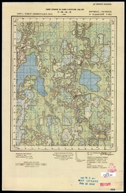
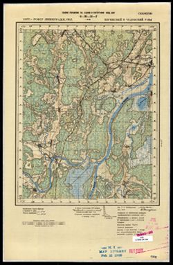
- Description:
- 1938
- Subject:
- Topical Subject: Soviet Union, Topical Subject: Maps, and Geographic Subject: Bibikovo
- Publisher:
- Главное управление государственной съемки и картографии НКВД СССР
- Language:
- Russian
- Date Created:
- 1941
- Identifier:
- VAC9619-002901
- Genre:
- Military Maps and Topographic Maps
- Geographic Location:
- Coordinates: 56.667, 34.5, 56.833, 34.75
- Related URL:
- Download GeoTIFF: https://drive.google.com/file/d/1CtQQ4NsW080rVS_8Nh5ngD6133CXboqw/view?usp=sharing and Catalog URL: http://iucat.iu.edu/catalog/5020131
- Abstract:
- Modern area represented: Бибиково (Bibikovo), Tverskaya oblast, Russia
- Call Number:
- GM G7000 s50 .S68 sheet O-36-118-C
- Caption:
- Для служебного пользования
- City:
- Бибиково (Bibikovo)
- Copyright Holder:
- No Copyright - United States
- Country:
- СССР (USSR)
- State/Province:
- Луковниковский район (Lukovnikovsky district), Калининская область (Kalinin oblast), and Высоковский район (Vysokovsky district)
- Physical Description:
- Scale: 1:50,000
- Persistent URL:
- http://purl.dlib.indiana.edu/iudl/images/VAC9619/VAC9619-002901
- Provenance:
- DMA Topographic Center, Army Map Service Library, OMAHA, Library of Congress Geography & Map Division
-
- Description:
- 1938
- Subject:
- Geographic Subject: Yur'yevo, Topical Subject: Soviet Union, and Topical Subject: Maps
- Publisher:
- Главное управление государственной съемки и картографии НКВД СССР
- Language:
- Russian
- Identifier:
- VAC9619-002911
- Genre:
- Military Maps and Topographic Maps
- Geographic Location:
- Coordinates: 58, 31.5, 58.167, 31.75
- Related URL:
- Catalog URL: http://iucat.iu.edu/catalog/5020131 and Download GeoTIFF: https://drive.google.com/file/d/1_4MNylz2L__3yRfDgH-rc80b98Suz4MY/view?usp=sharing
- Abstract:
- Modern area represented: Юрьево (Yur'yevo), Novgorodskaya oblast, Russia
- Call Number:
- GM G7000 s50 .S68 sheet O-36-64-С
- Caption:
- Для служебного пользования
- City:
- Юрьево (Yur'yevo)
- Copyright Holder:
- No Copyright - United States
- Country:
- СССР (USSR)
- State/Province:
- Лычковский район (Lychkovsky district), Старорусский район (Starorussky district), and Ленинградская область (Leningrad oblast)
- Physical Description:
- Scale: 1:50,000
- Persistent URL:
- http://purl.dlib.indiana.edu/iudl/images/VAC9619/VAC9619-002911
- Provenance:
- M. I. Map Library, Library of Congress Geography & Map Division
-
- Description:
- 1937
- Subject:
- Topical Subject: Maps, Geographic Subject: Pogostye, and Topical Subject: Soviet Union
- Publisher:
- Главное управление государственной съемки и картографии НКВД СССР
- Language:
- Russian
- Date Created:
- 1941
- Identifier:
- VAC9619-003010
- Genre:
- Topographic Maps and Military Maps
- Geographic Location:
- Coordinates: 59.5, 31.5, 59.667, 31.75
- Related URL:
- Download GeoTIFF: https://drive.google.com/file/d/1pUntXRKjdqDtToJwmqYz9UGC_8naXvsZ/view?usp=sharing and Catalog URL: http://iucat.iu.edu/catalog/5020131
- Abstract:
- Modern area represented: Pogostye, Leningrad oblast, Russia
- Call Number:
- G7000 s50 .S68 sheet O-36-16-A
- Caption:
- Для служебного пользования,Captured map
- City:
- Погостье (Pogostye)
- Copyright Holder:
- No Copyright - United States
- Country:
- СССР (USSR)
- State/Province:
- Мгинский район (Mginsky district), Тосненский район (Tosnensky district), Киришский район (Kirishsky district), РСФСР (RSFSR), and Ленинградская область (Len...
- Physical Description:
- Scale: 1:50,000
- Persistent URL:
- http://purl.dlib.indiana.edu/iudl/images/VAC9619/VAC9619-003010
- Provenance:
- Army Map Service Library, OMAHA, Library of Congress Geography & Map Division
-
- Description:
- 1937
- Subject:
- Topical Subject: Maps, Topical Subject: Soviet Union, and Geographic Subject: Olomna
- Publisher:
- Главное управление государственной съемки и картографии НКВД СССР
- Language:
- Russian
- Identifier:
- VAC9619-003011
- Genre:
- Topographic Maps and Military Maps
- Geographic Location:
- Coordinates: 59.5, 31.75, 59.667, 32
- Related URL:
- Download GeoTIFF: https://drive.google.com/file/d/1KLZhvz4VV7m4MqP7OxUfyZwY0ynP_hzS/view?usp=sharing and Catalog URL: http://iucat.iu.edu/catalog/5020131
- Abstract:
- Modern area represented: Olomna, Leningrad oblast, Russia
- Call Number:
- G7000 s50 .S68 sheet O-36-16-B
- Caption:
- Для служебного пользования,Captured map
- City:
- Оломна (Olomna)
- Copyright Holder:
- No Copyright - United States
- Country:
- СССР (USSR)
- State/Province:
- РСФСР (RSFSR), Мгинский район (Mginsky district), Киришский район (Kirishsky district), and Ленинградская область (Leningrad oblast)
- Physical Description:
- Scale: 1:50,000
- Persistent URL:
- http://purl.dlib.indiana.edu/iudl/images/VAC9619/VAC9619-003011
- Provenance:
- DMA Topographic Center, Army Map Service Library, Library of Congress Geography & Map Division
-
- Description:
- 1937
- Subject:
- Topical Subject: Maps, Topical Subject: Soviet Union, and Geographic Subject: Zenino
- Publisher:
- Главное управление государственной съемки и картографии НКВД СССР
- Language:
- Russian
- Identifier:
- VAC9619-003012
- Genre:
- Military Maps and Topographic Maps
- Geographic Location:
- Coordinates: 59.333, 31.5, 59.5, 31.75
- Related URL:
- Download GeoTIFF: https://drive.google.com/file/d/1jQcCmrOddHVgk6gEwdGWG0-JCsxASGdI/view?usp=sharing and Catalog URL: http://iucat.iu.edu/catalog/5020131
- Abstract:
- Modern area represented: Zenino, Leningrad oblast, Russia
- Call Number:
- G7000 s50 .S68 sheet O-36-16-C
- Caption:
- Для служебного пользования
- City:
- Зенино (Zenino)
- Copyright Holder:
- No Copyright - United States
- Country:
- СССР (USSR)
- State/Province:
- Киришский район (Kirishsky district), РСФСР (RSFSR), Чудовский район (Chudovsky district), Ленинградская область (Leningrad oblast), and Тосненский район (To...
- Physical Description:
- Scale: 1:50,000
- Persistent URL:
- http://purl.dlib.indiana.edu/iudl/images/VAC9619/VAC9619-003012
- Provenance:
- M. I. Map Library, Atlasblatt
-
- Description:
- 1937
- Subject:
- Geographic Subject: Novyye Kirishi, Topical Subject: Maps, and Topical Subject: Soviet Union
- Publisher:
- Главное управление государственной съемки и картографии НКВД СССР
- Language:
- Russian
- Identifier:
- VAC9619-003013
- Genre:
- Topographic Maps and Military Maps
- Geographic Location:
- Coordinates: 59.333, 31.75, 59.5, 32
- Related URL:
- Download GeoTIFF: https://drive.google.com/file/d/1T7pfRIQjH722Y0tIfJuhkVuXkM36_Cqz/view?usp=sharing and Catalog URL: http://iucat.iu.edu/catalog/5020131
- Abstract:
- Modern area represented: Novyye Kirishi, Leningrad oblast, Russia
- Call Number:
- G7000 s50 .S68 sheet O-36-16-D
- Caption:
- Секретно
- City:
- Новые Кириши (Novyye Kirishi)
- Copyright Holder:
- No Copyright - United States
- Country:
- СССР (USSR)
- State/Province:
- Киришский район (Kirishsky district), Чудовский район (Chudovsky district), Ленинградская область (Leningrad oblast), and РСФСР (RSFSR)
- Physical Description:
- Scale: 1:50,000
- Persistent URL:
- http://purl.dlib.indiana.edu/iudl/images/VAC9619/VAC9619-003013
- Provenance:
- M. I. Map Library, G000-30
-
- Description:
- 1936
- Subject:
- Topical Subject: Maps, Topical Subject: Soviet Union, and Geographic Subject: Pcheva
- Publisher:
- Главное управление государственной съемки и картографии НКВД СССР
- Language:
- Russian
- Identifier:
- VAC9619-003054
- Genre:
- Topographic Maps and Military Maps
- Geographic Location:
- Coordinates: 59.5, 32, 59.667, 32.25
- Related URL:
- Download GeoTIFF: https://drive.google.com/file/d/1scUcJxW6OnLfOYb-Qeu5zHzh2eG0bkxd/view?usp=sharing and Catalog URL: http://iucat.iu.edu/catalog/5020131
- Abstract:
- Modern area represented: Pcheva, Leningrad oblast, Russia
- Call Number:
- GM G7000 s50 .S68 sheet O-36-17-A
- Caption:
- Для служебного пользования,Captured map
- City:
- Пчева (Pcheva)
- Copyright Holder:
- No Copyright - United States
- Country:
- СССР (USSR)
- State/Province:
- РСФСР (RSFSR), Киришский район (Kirishsky district), Ленинградская область (Leningrad oblast), and Волховский район (Volkhov district)
- Physical Description:
- Scale: 1:50,000
- Persistent URL:
- http://purl.dlib.indiana.edu/iudl/images/VAC9619/VAC9619-003054
- Provenance:
- Army Map Service Library, OMAHA, Library of Congress Geography & Map Division
-
- Description:
- 1936
- Subject:
- Topical Subject: Soviet Union, Geographic Subject: Motokhovo, and Topical Subject: Maps
- Publisher:
- Главное управление государственной съемки и картографии НКВД СССР
- Language:
- Russian
- Identifier:
- VAC9619-003055
- Genre:
- Topographic Maps and Military Maps
- Geographic Location:
- Coordinates: 59.5, 32.25, 59.667, 32.5
- Related URL:
- Download GeoTIFF: https://drive.google.com/file/d/1OSXXWrNmak2flUfvvQS3WZsIMOH68RHQ/view?usp=sharing and Catalog URL: http://iucat.iu.edu/catalog/5020131
- Abstract:
- Modern area represented: Motokhovo, Leningrad oblast, Russia
- Call Number:
- GM G7000 s50 .S68 sheet O-36-17-B
- Caption:
- Для служебного пользования,Captured map
- City:
- Мотохово (Motokhovo)
- Copyright Holder:
- No Copyright - United States
- Country:
- СССР (USSR)
- State/Province:
- Киришский район (Kirishsky district), Ленинградская область (Leningrad oblast), Волховский район (Volkhov district), and РСФСР (RSFSR)
- Physical Description:
- Scale: 1:50,000
- Persistent URL:
- http://purl.dlib.indiana.edu/iudl/images/VAC9619/VAC9619-003055
- Provenance:
- Army Map Service Library, OMAHA, Library of Congress Geography & Map Division
-
- Description:
- 1936
- Subject:
- Topical Subject: Soviet Union, Geographic Subject: Kirishi, and Topical Subject: Maps
- Publisher:
- Главное управление государственной съемки и картографии НКВД СССР
- Language:
- Russian
- Identifier:
- VAC9619-003056
- Genre:
- Military Maps and Topographic Maps
- Geographic Location:
- Coordinates: 59.333, 32, 59.5, 32.25
- Related URL:
- Download GeoTIFF: https://drive.google.com/file/d/1PZDNWuiGlf6CtZIKyldEtn0xpA8D-pmZ/view?usp=sharing and Catalog URL: http://iucat.iu.edu/catalog/5020131
- Abstract:
- Modern area represented: Kirishi, Russia
- Call Number:
- GM G7000 s50 .S68 sheet O-36-17-C
- Caption:
- Для служебного пользования,Captured map
- City:
- Кириши (Kirishi)
- Copyright Holder:
- No Copyright - United States
- Country:
- СССР (USSR)
- State/Province:
- Киришский район (Kirishsky district), РСФСР (RSFSR), Чудовский район (Chudovsky district), and Ленинградская область (Leningrad oblast)
- Physical Description:
- Scale: 1:50,000
- Persistent URL:
- http://purl.dlib.indiana.edu/iudl/images/VAC9619/VAC9619-003056
- Provenance:
- Army Map Service Library, OMAHA, Library of Congress Geography & Map Division
-
- Description:
- 1936
- Subject:
- Topical Subject: Maps, Topical Subject: Soviet Union, and Geographic Subject: Pchevzha
- Publisher:
- Главное управление государственной съемки и картографии НКВД СССР
- Language:
- Russian
- Identifier:
- VAC9619-003057
- Genre:
- Military Maps and Topographic Maps
- Geographic Location:
- Coordinates: 59.333, 32.25, 59.5, 32.5
- Related URL:
- Download GeoTIFF: https://drive.google.com/file/d/1v049okttpIuIi2N6AI215TM1oz04h7PN/view?usp=sharing and Catalog URL: http://iucat.iu.edu/catalog/5020131
- Abstract:
- Modern area represented: Pchevzha, Russia
- Call Number:
- GM G7000 s50 .S68 sheet O-36-17-D
- Caption:
- Для служебного пользования
- City:
- Пчевжа (Pchevzha)
- Copyright Holder:
- No Copyright - United States
- Country:
- СССР (USSR)
- State/Province:
- Ленинградская область (Leningrad oblast) and РСФСР (RSFSR)
- Physical Description:
- Scale: 1:50,000
- Persistent URL:
- http://purl.dlib.indiana.edu/iudl/images/VAC9619/VAC9619-003057
- Provenance:
- Army Map Service Library, OMAHA, Library of Congress Geography & Map Division
-
- Description:
- 1936
- Subject:
- Topical Subject: Soviet Union, Geographic Subject: Lipnaya Gorka, and Topical Subject: Maps
- Publisher:
- Главное управление государственной съемки и картографии НКВД СССР
- Language:
- Russian
- Identifier:
- VAC9619-003058
- Genre:
- Topographic Maps and Military Maps
- Geographic Location:
- Coordinates: 59.5, 33, 59.667, 33.25
- Related URL:
- Catalog URL: http://iucat.iu.edu/catalog/5020131 and Download GeoTIFF: https://drive.google.com/file/d/1zbld7RZNNdFmoim1wQUggfreWdLbj14B/view?usp=sharing
- Abstract:
- Modern area represented: Lipnaya Gorka, Russia
- Call Number:
- GM G7000 s50 .S68 sheet O-36-19-A
- Caption:
- Для cлужебного пользования
- City:
- Липная Горка (Lipnaya Gorka)
- Copyright Holder:
- No Copyright - United States
- Country:
- СССР (USSR)
- State/Province:
- Ленинградская область (Leningrad oblast), РСФСР (RSFSR), and Тихвинский район (Tikhvin district)
- Physical Description:
- Scale: 1:50,000
- Persistent URL:
- http://purl.dlib.indiana.edu/iudl/images/VAC9619/VAC9619-003058
- Provenance:
- DMA Topographic Center, Army Map Service Library, OMAHA, Library of Congress Geography & Map Division
-
- Description:
- 1936
- Subject:
- Geographic Subject: Lazarevichi, Topical Subject: Maps, and Topical Subject: Soviet Union
- Publisher:
- Главное управление государственной съемки и картографии НКВД СССР
- Language:
- Russian
- Identifier:
- VAC9619-003059
- Genre:
- Topographic Maps and Military Maps
- Geographic Location:
- Coordinates: 59.5, 33.25, 59.667, 33.5
- Related URL:
- Catalog URL: http://iucat.iu.edu/catalog/5020131 and Download GeoTIFF: https://drive.google.com/file/d/1N0zBvwW3Aa935pbqhlVic9QkoAOigRei/view?usp=sharing
- Abstract:
- Modern area represented: Lazarevichi, Russia
- Call Number:
- GM G7000 s50 .S68 sheet O-36-19-B
- Caption:
- Для служебного пользования
- City:
- Лазаревичи (Lazarevichi)
- Copyright Holder:
- No Copyright - United States
- Country:
- СССР (USSR)
- State/Province:
- Тихвинский район (Tikhvin district), РСФСР (RSFSR), and Ленинградская область (Leningrad oblast)
- Physical Description:
- Scale: 1:50,000
- Persistent URL:
- http://purl.dlib.indiana.edu/iudl/images/VAC9619/VAC9619-003059
- Provenance:
- M. I. Map Library, Library of Congress Geography & Map Division
-
- Description:
- 1930
- Subject:
- Geographic Subject: Karaganda oblast, Topical Subject: Soviet Union, and Topical Subject: Maps
- Publisher:
- Главное управление государственной съемки и картографии НКВД СССР
- Language:
- Russian
- Date Created:
- 1938
- Identifier:
- VAC9619-002542
- Genre:
- Military Maps and Topographic Maps
- Geographic Location:
- Coordinates: 46, 73.5, 46.333, 74
- Related URL:
- Catalog URL: https://iucat.iu.edu/catalog/5020129 and Download GeoTIFF: https://drive.google.com/file/d/1G7EW-o_dMLmbj2FUpobeXkZDrJDT-tTc/view?usp=sharing
- Abstract:
- Modern area represented: Karaganda oblast, Kazakhstan
- Call Number:
- G7000 s100 .S7 sheet L-43-64
- Copyright Holder:
- No Copyright - United States
- Country:
- СССР (USSR)
- State/Province:
- Четский район (Shet district) and Карагандинская область (Karaganda oblast)
- Physical Description:
- Scale: 1:100,000
- Persistent URL:
- http://purl.dlib.indiana.edu/iudl/images/VAC9619/VAC9619-002542
- Provenance:
- DMA Topographic Center, Library of Congress G & M Division, Army Map Service Library, OMAHA
-
- Description:
- 1931
- Subject:
- Topical Subject: Soviet Union, Topical Subject: Maps, and Geographic Subject: Aktogay district
- Publisher:
- Главное управление государственной съемки и картографии НКВД СССР
- Language:
- Russian
- Date Created:
- 1938
- Identifier:
- VAC9619-002541
- Genre:
- Military Maps and Topographic Maps
- Geographic Location:
- Coordinates: 46.667, 75, 47, 75.5
- Related URL:
- Download GeoTIFF: https://drive.google.com/file/d/1hAvIa9wm1eERsTMs4wjdBTZH3QbaW5IC/view?usp=sharing and Catalog URL: https://iucat.iu.edu/catalog/5020129
- Abstract:
- Modern area represented: Aktogay district, Karaganda oblast, Kazakhstan
- Call Number:
- G7000 s100 .S7 sheet L-43-43
- Caption:
- Для служебного пользования
- Copyright Holder:
- No Copyright - United States
- Country:
- СССР (USSR)
- State/Province:
- Карагандинская область (Karaganda oblast) and Коунрадский район (Kounrad district)
- Physical Description:
- Scale: 1:100,000
- Persistent URL:
- http://purl.dlib.indiana.edu/iudl/images/VAC9619/VAC9619-002541
- Provenance:
- DMA Topographic Center, Library of Congress G & M Division, Army Map Service Library, OMAHA
-
- Description:
- 1932
- Subject:
- Topical Subject: Maps, Geographic Subject: Shet district, and Topical Subject: Soviet Union
- Publisher:
- Главное управление государственной съемки и картографии НКВД СССР
- Language:
- Russian
- Date Created:
- 1938
- Identifier:
- VAC9619-002540
- Genre:
- Topographic Maps and Military Maps
- Geographic Location:
- Coordinates: 46.667, 73.5, 47, 74
- Related URL:
- Download GeoTIFF: https://drive.google.com/file/d/1yqXC6ldWLf-GiHEDmF9JIt2-KLB-xVzz/view?usp=sharing and Catalog URL: https://iucat.iu.edu/catalog/5020129
- Abstract:
- Modern area represented: Shet district, Karaganda oblast, Kazakhstan
- Call Number:
- G7000 s100 .S7 sheet L-43-40
- Copyright Holder:
- No Copyright - United States
- Country:
- СССР (USSR)
- State/Province:
- Четский район (Shet district) and Карагандинская область (Karaganda oblast)
- Physical Description:
- Scale: 1:100,000
- Persistent URL:
- http://purl.dlib.indiana.edu/iudl/images/VAC9619/VAC9619-002540
- Provenance:
- DMA Topographic Center, Library of Congress G & M Division, Army Map Service Library
-
- Description:
- 1932
- Subject:
- Topical Subject: Maps, Geographic Subject: Shet district, and Topical Subject: Soviet Union
- Publisher:
- Главное управление государственной съемки и картографии НКВД СССР
- Language:
- Russian
- Date Created:
- 1938
- Identifier:
- VAC9619-002539
- Genre:
- Military Maps and Topographic Maps
- Geographic Location:
- Coordinates: 46.667, 73, 47, 73.5
- Related URL:
- Catalog URL: https://iucat.iu.edu/catalog/5020129 and Download GeoTIFF: https://drive.google.com/file/d/1VFXA259FbiIixp0she4-S-AYr7CONug0/view?usp=sharing
- Abstract:
- Modern area represented: Shet district, Karaganda oblast, Kazakhstan
- Call Number:
- G7000 s100 .S7 sheet L-43-39
- Copyright Holder:
- No Copyright - United States
- Country:
- СССР (USSR)
- State/Province:
- Карагандинская область (Karaganda oblast) and Четский район (Shet district)
- Physical Description:
- Scale: 1:100,000
- Persistent URL:
- http://purl.dlib.indiana.edu/iudl/images/VAC9619/VAC9619-002539
- Provenance:
- DMA Topographic Center, Library of Congress G & M Division, Army Map Service Library, Auswärtiges Amt. Geographischer Dienst, OMAHA
-
- Description:
- 1934
- Subject:
- Topical Subject: Soviet Union, Topical Subject: Maps, and Geographic Subject: Aktogay district
- Publisher:
- Главное управление государственной съемки и картографии НКВД СССР
- Language:
- Russian
- Date Created:
- 1938
- Identifier:
- VAC9619-002537
- Genre:
- Military Maps and Topographic Maps
- Geographic Location:
- Coordinates: 47.333, 75, 47.667, 75.5
- Related URL:
- Download GeoTIFF: https://drive.google.com/file/d/1HvUN0cYNLD3PZs0CPw1JqQCCRNWdkeVH/view?usp=sharing and Catalog URL: https://iucat.iu.edu/catalog/5020129
- Abstract:
- Modern area represented: Aktogay district, Karaganda oblast, Kazakhstan
- Call Number:
- G7000 s100 .S7 sheet L-43-19
- Copyright Holder:
- No Copyright - United States
- Country:
- СССР (USSR)
- State/Province:
- Коунрадский район (Kounrad district) and Карагандинская область (Karaganda oblast)
- Physical Description:
- Scale: 1:100,000
- Persistent URL:
- http://purl.dlib.indiana.edu/iudl/images/VAC9619/VAC9619-002537
- Provenance:
- DMA Topographic Center, Library of Congress G & M Division, Army Map Service Library, Auswärtiges Amt. Geographischer Dienst, OMAHA
-

- Description:
- 1938
- Subject:
- Topical Subject: Maps, Topical Subject: Soviet Union, and Geographic Subject: Nizhniye Sergi
- Publisher:
- Главное управление государственной съемки и картографии НКВД СССР
- Language:
- Russian
- Identifier:
- VAC9619-002300
- Genre:
- Topographic Maps and Military Maps
- Geographic Location:
- Coordinates: 56.3333, 59, 56.6667, 59.5
- Related URL:
- Download GeoTIFF: https://drive.google.com/file/d/1NO9kt2bJTbNiD91eJqzhQEITkT6AmIda/view?usp=sharing and Catalog URL: https://iucat.iu.edu/catalog/5020129
- Abstract:
- Modern area represented: Nizhniye Sergi, Russia
- Call Number:
- G7000 s100 .S7 sheet O-40-131
- City:
- Нижние Серги (Nizhniye Sergi)
- Copyright Holder:
- No Copyright - United States
- Country:
- СССР (USSR)
- State/Province:
- Свердловская область (Sverdlovsk oblast), Артинский район (Artinsky district), Нижнесергинский район (Nizhneserginsky district), Нязепетровский район (Nyazep...
- Physical Description:
- Scale: 1:100,000
- Persistent URL:
- http://purl.dlib.indiana.edu/iudl/images/VAC9619/VAC9619-002300
- Provenance:
- DMA Topographic Center, Army Map Service Library
-
- Description:
- 1937
- Subject:
- Topical Subject: Soviet Union, Topical Subject: Maps, and Geographic Subject: Kunino
- Publisher:
- Главное управление государственной съемки и картографии НКВД СССР
- Language:
- Russian
- Identifier:
- VAC9619-000049
- Genre:
- Military Maps and Topographic Maps
- Geographic Location:
- Coordinates: 58.3333, 31.25, 58.5, 31.5
- Related URL:
- Catalog URL: http://iucat.iu.edu/catalog/5020131 and Download GeoTIFF: https://drive.google.com/open?id=16SW5j9ytBliEz0XXx8zciIcvzhTfXs83
- Abstract:
- Modern area represented: Kunino, Novgorod oblast, Russia
- Call Number:
- G7000 s50 .S68 sheet O-36-51-D
- Caption:
- Для служебного пользования,Captured map
- City:
- Кунино (Kunino)
- Copyright Holder:
- No Copyright - United States
- Country:
- СССР (USSR)
- State/Province:
- РСФСР (RSFSR), Новгородский район (Novgorod district), and Ленинградская область (Leningrad oblast)
- Physical Description:
- Scale: 1:50,000
- Persistent URL:
- http://purl.dlib.indiana.edu/iudl/images/VAC9619/VAC9619-000049
- Provenance:
- DMA Topographic Center, Army Map Service Library, OMAHA, Library of Congress Geography & Map Division
-
- Description:
- 1937
- Subject:
- Topical Subject: Soviet Union, Topical Subject: Maps, and Geographic Subject: Sergovo
- Publisher:
- Главное управление государственной съемки и картографии НКВД СССР
- Language:
- Russian
- Identifier:
- VAC9619-000048
- Genre:
- Military Maps and Topographic Maps
- Geographic Location:
- Coordinates: 58.3333, 31, 58.5, 31.25
- Related URL:
- Download GeoTIFF: https://drive.google.com/open?id=1yPXA-9rhz0jzArm-FvAtrBa2cRrIodek and Catalog URL: http://iucat.iu.edu/catalog/5020131
- Abstract:
- Modern area represented: Sergovo, Novgorod oblast, Russia
- Call Number:
- G7000 s50 .S68 sheet O-36-51-C
- Caption:
- Для служебного пользования
- City:
- Сергово (Sergovo)
- Copyright Holder:
- No Copyright - United States
- Country:
- СССР (USSR)
- State/Province:
- РСФСР (RSFSR), Ленинградская область (Leningrad oblast), and Новгородский район (Novgorod district)
- Physical Description:
- Scale: 1:50,000
- Persistent URL:
- http://purl.dlib.indiana.edu/iudl/images/VAC9619/VAC9619-000048
- Provenance:
- DMA Topographic Center, Army Map Service Library, OMAHA, Library of Congress Geography & Map Division
-
- Description:
- 1937
- Subject:
- Geographic Subject: Sennaya Kerest, Topical Subject: Maps, and Topical Subject: Soviet Union
- Publisher:
- Главное управление государственной съемки и картографии НКВД СССР
- Language:
- Russian
- Date Created:
- 1941
- Identifier:
- VAC9619-000045
- Genre:
- Military Maps and Topographic Maps
- Geographic Location:
- Coordinates: 59, 31.25, 59.1667, 31.5
- Related URL:
- Catalog URL: http://iucat.iu.edu/catalog/5020131 and Download GeoTIFF: https://drive.google.com/open?id=1Xt8g3fvVgQ95j7zy7NFQC1RMN4YRgcmi
- Abstract:
- Modern area represented: Sennaya Kerest, Novgorod oblast, Russia
- Call Number:
- G7000 s50 .S68 sheet O-36-27-D
- Caption:
- Для служебного пользования,Captured map
- City:
- Сенная Кересть (Sennaya Kerest’)
- Copyright Holder:
- No Copyright - United States
- Country:
- СССР (USSR)
- State/Province:
- Тосненский район (Tosnensky district), Ленинградская область (Leningrad oblast), РСФСР (RSFSR), and Чудовский район (Chudovsky district)
- Physical Description:
- Scale: 1:50,000
- Persistent URL:
- http://purl.dlib.indiana.edu/iudl/images/VAC9619/VAC9619-000045
- Provenance:
- DMA Topographic Center, Army Map Service Library, OMAHA, Library of Congress Geography & Map Division
-
- Description:
- 1937
- Subject:
- Topical Subject: Soviet Union, Geographic Subject: Babino, and Topical Subject: Maps
- Publisher:
- Главное управление государственной съемки и картографии НКВД СССР
- Language:
- Russian
- Date Created:
- 1941
- Identifier:
- VAC9619-000044
- Genre:
- Military Maps and Topographic Maps
- Geographic Location:
- Coordinates: 59.1667, 31.25, 59.3333, 31.5
- Related URL:
- Download GeoTIFF: https://drive.google.com/open?id=117pSSxlZhQGDjutRAtCtoaIqVDkp3Xa0 and Catalog URL: http://iucat.iu.edu/catalog/5020131
- Abstract:
- Modern area represented:
- Call Number:
- G7000 s50 .S68 sheet O-36-27-B
- Caption:
- Секретно,Captured map
- City:
- Бабино (Babino)
- Copyright Holder:
- No Copyright - United States
- Country:
- СССР (USSR)
- State/Province:
- Тосненский район (Tosnensky district), РСФСР (RSFSR), Ленинградская область (Leningrad oblast), and Чудовский район (Chudovsky district)
- Physical Description:
- Scale: 1:50,000
- Persistent URL:
- http://purl.dlib.indiana.edu/iudl/images/VAC9619/VAC9619-000044
- Provenance:
- DMA Topographic Center, Army Map Service Library, OMAHA, Library of Congress Geography & Map Division
-
- Description:
- 1937
- Subject:
- Topical Subject: Soviet Union, Geographic Subject: Korkino, and Topical Subject: Maps
- Publisher:
- Главное управление государственной съемки и картографии НКВД СССР
- Language:
- Russian
- Date Created:
- 1941
- Identifier:
- VAC9619-000043
- Genre:
- Topographic Maps and Military Maps
- Geographic Location:
- Coordinates: 59.1667, 31, 59.3333, 31.25
- Related URL:
- Catalog URL: http://iucat.iu.edu/catalog/5020131 and Download GeoTIFF: https://drive.google.com/open?id=1bsTUMvoE0kAKG1XeVu6aZENX9H3qNZIO
- Abstract:
- Modern area represented: Korkino, Russia
- Call Number:
- G7000 s50 .S68 sheet O-36-27-A
- Caption:
- Для служебного пользования
- City:
- Коркино (Korkino)
- Copyright Holder:
- No Copyright - United States
- Country:
- СССР (USSR)
- State/Province:
- РСФСР (RSFSR), Тосненский район (Tosnensky district), and Ленинградская область (Leningrad oblast)
- Physical Description:
- Scale: 1:50,000
- Persistent URL:
- http://purl.dlib.indiana.edu/iudl/images/VAC9619/VAC9619-000043
- Provenance:
- DMA Topographic Center, Army Map Service Library, OMAHA, Library of Congress Geography & Map Division
-
- Description:
- 1937
- Subject:
- Geographic Subject: Kubolovo, Topical Subject: Soviet Union, and Topical Subject: Maps
- Publisher:
- Главное управление государственной съемки и картографии НКВД СССР
- Language:
- Russian
- Date Created:
- 1941
- Identifier:
- VAC9619-000042
- Genre:
- Topographic Maps and Military Maps
- Geographic Location:
- Coordinates: 59, 30.75, 59.1667, 31
- Related URL:
- Download GeoTIFF: https://drive.google.com/open?id=1Zo_O0BWAAl8rG6V8h9VkfMkerMU104rZ and Catalog URL: http://iucat.iu.edu/catalog/5020131
- Abstract:
- Modern area represented: Kubolovo, Russia
- Call Number:
- G7000 s50 .S68 sheet O-36-26-D
- Caption:
- Секретно,Captured map
- City:
- Куболово (Kubolovo)
- Copyright Holder:
- No Copyright - United States
- Country:
- СССР (USSR)
- State/Province:
- Тосненский район (Tosnensky district), Оредежский район (Oredezhsky district), Ленинградская область (Leningrad oblast), Новгородский район (Novgorod distric...
- Physical Description:
- Scale: 1:50,000
- Persistent URL:
- http://purl.dlib.indiana.edu/iudl/images/VAC9619/VAC9619-000042
- Provenance:
- DMA Topographic Center, Army Map Service Library, OMAHA, Library of Congress Geography & Map Division
-

- Description:
- 1937
- Subject:
- Geographic Subject: Gummolovo and Topical Subject: Soviet Union
- Publisher:
- Главное управление государственной съемки и картографии НКВД СССР
- Language:
- Russian
- Date Created:
- 1941
- Identifier:
- VAC9619-000040
- Genre:
- Military Maps and Topographic Maps
- Geographic Location:
- Coordinates: 59.1667, 30.75, 59.3333, 31
- Related URL:
- Catalog URL: http://iucat.iu.edu/catalog/5020131 and Download GeoTIFF: https://drive.google.com/open?id=1Thglq8S3ntpZfPmHWFNFQ1QHmQpoR5Lu
- Abstract:
- Modern area represented: Gummolovo, Russia
- Call Number:
- G7000 s50 .S68 sheet O-36-26-B
- Caption:
- Для служебного пользования
- City:
- Гуммолово (Gummolovo)
- Copyright Holder:
- No Copyright - United States
- Country:
- СССР (USSR)
- State/Province:
- Ленинградская область (Leningrad oblast), Тосненский район (Tosnensky district), and РСФСР (RSFSR)
- Physical Description:
- Scale: 1:50,000
- Persistent URL:
- http://purl.dlib.indiana.edu/iudl/images/VAC9619/VAC9619-000040
- Provenance:
- Army Map Service Library, OMAHA, Library of Congress Geography & Map Division
-
- Description:
- 1937
- Subject:
- Geographic Subject: Nesterkovo, Topical Subject: Maps, and Topical Subject: Soviet Union
- Publisher:
- Главное управление государственной съемки и картографии НКВД СССР
- Language:
- Russian
- Date Created:
- 1941
- Identifier:
- VAC9619-000041
- Genre:
- Topographic Maps and Military Maps
- Geographic Location:
- Coordinates: 59, 30.5, 59.1667, 30.75
- Related URL:
- Catalog URL: http://iucat.iu.edu/catalog/5020131 and Download GeoTIFF: https://drive.google.com/open?id=15zmLpNAtR49LfgQ9suZDHQMWXpE-EEqP
- Abstract:
- Modern area represented: Nesterkovo, Russia
- Call Number:
- G7000 s50 .S68 sheet O-36-26-C
- Caption:
- Секретно,Captured map
- City:
- Нестерково (Nesterkovo)
- Copyright Holder:
- No Copyright - United States
- Country:
- СССР (USSR)
- State/Province:
- РСФСР (RSFSR), Оредежский район (Oredezhsky district), Тосненский район (Tosnensky district), and Ленинградская область (Leningrad oblast)
- Physical Description:
- Scale: 1:50,000
- Persistent URL:
- http://purl.dlib.indiana.edu/iudl/images/VAC9619/VAC9619-000041
- Provenance:
- DMA Topographic Center, Army Map Service Library, OMAHA, Library of Congress Geography & Map Division
-
- Description:
- 1937
- Subject:
- Geographic Subject: Lyuban, Topical Subject: Soviet Union, and Topical Subject: Maps
- Publisher:
- Главное управление государственной съемки и картографии НКВД СССР
- Language:
- Russian
- Date Created:
- 1941
- Identifier:
- VAC9619-000037
- Genre:
- Topographic Maps and Military Maps
- Geographic Location:
- Coordinates: 59.3333, 31, 59.5, 31.25
- Related URL:
- Download GeoTIFF: https://drive.google.com/open?id=1tL7TavgtAjhyMQpivDTR1Q14PmTqYfr3 and Catalog URL: http://iucat.iu.edu/catalog/5020131
- Abstract:
- Modern area represented: Lyuban, Russia
- Call Number:
- G7000 s50 .S68 sheet O-36-15-C
- Caption:
- Для служебного пользования,Captured map
- City:
- Любань (Lyuban)
- Copyright Holder:
- No Copyright - United States
- Country:
- СССР (USSR)
- State/Province:
- Тосненский район (Tosnensky district), Ленинградская область (Leningrad oblast), and РСФСР (RSFSR)
- Physical Description:
- Scale: 1:50,000
- Persistent URL:
- http://purl.dlib.indiana.edu/iudl/images/VAC9619/VAC9619-000037
- Provenance:
- DMA Topographic Center, Army Map Service Library, Library of Congress Geography & Map Division
