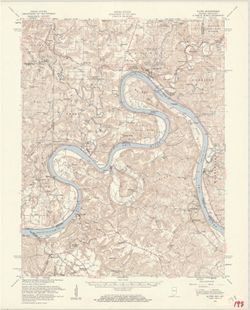
Geographic Subject: Saint Joseph County (Mich.), Geographic Subject: Cass County (Mich.), Topical Subject: Vegetation mapping, and Geographic Subject: Elkhar...
Creator:
Geological Survey (U.S.) and Michigan. State Highway Department
Publisher:
Geological Survey (U.S.)
Date Created:
1959
Identifier:
VAC3073-M-01337
Genre:
15 minute topographic maps, Topographic maps, and Quadrangle maps
Mapped, edited, and published by the Geological Survey. Filing title: Vandalia, Mich.-Ind. Standard map series designation: AMS (Series) V762 3867 IV. [Editi...
Geographic Subject: Hardin County (Ky.), Geographic Subject: Harrison County (Ind.), Topical Subject: Vegetation mapping, Geographic Subject: Meade County (K...
Mapped by the Army Map Service , published for civil use by the Geological Survey. Filing title: Ekron, Ky.-Ind. Polyconic projection. Relief shown by contou...
Call Number:
G4090 s62 .G4 Ekron 1947 rep 1959 V
Caption:
Imprint: Washington, D.C. : published for civil use by the U.S. Geological Survey, 1959.
Physical Description:
Dimensions: 45 x 42 cm or smaller and Scale: 1:62,500
Mapped by the Geological Survey and the Army Map Service. Filing title: Alton, Ind.--Ky. Polyconic projection. Relief shown by contours and spot heights. Inc...
Geographic Subject: Breckinridge County (Ky.), Geographic Subject: Perry County (Ind.), Geographic Subject: Harrison County (Ind.), Geographic Subject: Meade...
Creator:
United States. Army Map Service and Geological Survey (U.S.)
Publisher:
Geological Survey (U.S.)
Date Created:
1959
Identifier:
VAC3073-M-01312
Genre:
Topographic maps, Quadrangle maps, and 15 minute topographic maps
Mapped by the Geological Survey and the Army Map Service. Filing title: Alton, Ind.--Ky. Polyconic projection. Relief shown by contours and spot heights. Inc...
Geographic Subject: Wabash County (Ill.), Topical Subject: Vegetation mapping, Geographic Subject: Lawrence County (Ill.), Geographic Subject: Gibson County ...
Creator:
Geological Survey (U.S.)
Publisher:
Geological Survey (U.S.)
Date Created:
1958
Identifier:
VAC3073-M-01412
Genre:
Quadrangle maps, Topographic maps, and 15 minute topographic maps
Geographic Subject: Darke County (Ohio), Geographic Subject: Wayne County (Ind.), and Geographic Subject: Randolph County (Ind.)
Creator:
Smith, Glenn S. (Glenn Shepard), Miller, W. L. (Topographer), Geological Survey (U.S.), Ellis, J. R. (Topographer), Ohio. Division of Geological Survey, Harr...
Publisher:
Geological Survey (U.S.)
Date Created:
1958
Identifier:
VAC3073-M-01415
Genre:
Topographic maps, Quadrangle maps, and 15 minute topographic maps
W.H. Herron, acting chief geogrpher , Glenn S. Smith, topographic engineer in charge , topography by R.L. Harrison and W.L. Miller , control by J.R. Ellis, J...
Call Number:
G4090 s62 .G4 Winchester 1916 rep1958
Caption:
Imprint: [Washington, D.C.] : U.S. Geological Survey, 1958
Physical Description:
Scale: 1:62,500 and Dimensions: 45 x 42 cm or smaller
Topical Subject: Vegetation mapping, Geographic Subject: Posey County (Ind.), Geographic Subject: Gallatin County (Ill.), Geographic Subject: White County (I...
Creator:
Geological Survey (U.S.)
Publisher:
Geological Survey (U.S.)
Date Created:
1958
Identifier:
VAC3073-M-01360
Genre:
Topographic maps, 15 minute topographic maps, and Quadrangle maps
United States, Department of the Interior, Geological Survey , State of Illinois, Department of Registration and Education, Geological Survey Division , Stat...
Topical Subject: Vegetation mapping, Geographic Subject: Jackson County (Ind.), Geographic Subject: Lawrence County (Ind.), Geographic Subject: Washington Co...
Creator:
Kilmartin, J. O. (Jerome O'Farrell), 1900-1979
Publisher:
Geological Survey (U.S.)
Date Created:
1958
Identifier:
VAC3073-M-01315
Genre:
Quadrangle maps, Topographic maps, and 15 minute topographic maps
Topography by J. O. Kilmartin, Shirley Waggener, W. H. Austin, G. G. Martin, and C. W. Birdseye. Polyconic projection. Relief shown by contours and spot heig...
Call Number:
G4090 s62 .G4 Bedford 1934 rep1958 V.
Caption:
Imprint: Washington, D.C. : U.S. Dept. of the Interior, Geological Survey, 1958
Physical Description:
Dimensions: 45 x 42 cm or smaller and Scale: 1:62,500
Geographic Subject: Sullivan County (Ind.), Geographic Subject: Crawford County (Ill.), and Geographic Subject: Knox County (Ind.)
Creator:
U.S. Coast and Geodetic Survey, Herron, W. H. (William Harrison), 1865-, Marshall, R. B. (Robert Bradford), 1867-1949, Graff, Fred, Jr., United States. Army,...
Publisher:
Geological Survey (U.S.)
Date Created:
1958
Identifier:
VAC3073-M-01317
Genre:
Quadrangle maps, Topographic maps, and 15 minute topographic maps
R.B. Marshall, Chief Geographer , W.H. Herron, Geographer in charge , topography by F. Graff, Jr. , control by Corps of Engineers U.S. Army, U.S. Coast and G...
Call Number:
G4090 s62 .G4 Birds 1942 rep1958
Caption:
Imprint: Washington, D.C. : Interior--Geological Survey, 1958. Washington, D.C. : for sale by U.S. Geological Survey and Imprint: Urbana, Illinois : State Ge...
Physical Description:
Scale: 1:62,500 and Dimensions: 45 x 42 cm or smaller
Geographic Subject: Crawford County (Ill.), Geographic Subject: Sullivan County (Ind.), Topical Subject: Vegetation mapping, and Geographic Subject: Clark Co...
Creator:
Geological Survey (U.S.), Indiana. Department of Conservation, and Illinois State Geological Survey
Publisher:
Geological Survey (U.S.)
Date Created:
1957
Identifier:
VAC3073-M-01346
Genre:
15 minute topographic maps, Topographic maps, and Quadrangle maps
Mapped, edited, and published by the Geological Survey , control by USGS, USC & GS, and USCE. Filing title: Hutsonville, Ill.-Ind. Standard map series de...
Call Number:
G4090 s62 .G4 Hutsonville 1957
Caption:
Imprint: Indianapolis, Ind. : Indiana Department of Conservation, [1958], Imprint: Washington, D.C. : for sale by U.S. Geological Survey, Imprint: Urbana, Il...
Physical Description:
Dimensions: 45 x 42 cm or smaller and Scale: 1:62,500

![Vandalia quadrangle, Michigan-Indiana : 15 minute series (topographic) [1959 reprint with vegetation]](https://iiif.uits.iu.edu/iiif/2/9019t543m%2Ffiles%2Fd71ad7ee-44b6-4efe-9cbc-388b2c880604/full/250,/0/default.jpg)
![Ekron quadrangle, Kentucky-Indiana : 15 minute series (topographic) [1959 printing with vegetation]](https://iiif.uits.iu.edu/iiif/2/c534gs22s%2Ffiles%2Fb6d7f856-1470-4ba1-a8ae-e16f6e63c025/full/250,/0/default.jpg)
![Alton quadrangle, Indiana--Kentucky : 15 minute series (topographic) [Vegetation version]](https://iiif.uits.iu.edu/iiif/2/ng452m33b%2Ffiles%2F49c9606f-c7c7-4f10-807b-1b5949009698/full/250,/0/default.jpg)
![Indiana-Illinois, Vincennes quadrangle : topography [1958 reprint with vegetation]](https://iiif.uits.iu.edu/iiif/2/bv73d371v%2Ffiles%2Fd8eeacfe-4380-4ba5-814d-cbf9ec40a053/full/250,/0/default.jpg)
![Indiana-Ohio, Winchester Quadrangle [1958 reprint]](https://iiif.uits.iu.edu/iiif/2/6t054k339%2Ffiles%2F32b26c9a-d997-4a33-91af-06b933ded058/full/250,/0/default.jpg)
![Indiana, 15 minute series (topographic), New Haven quadrangle [1958 printing with vegetation]](https://iiif.uits.iu.edu/iiif/2/2514pp79t%2Ffiles%2F0d5ff364-2218-4a66-8b60-6f38aa96fe7f/full/250,/0/default.jpg)
![Indiana Bedford quadrangle [1958 reprint with vegetation]](https://iiif.uits.iu.edu/iiif/2/d791tm28h%2Ffiles%2Fef8d95fb-aef9-4832-a975-c3812df114b6/full/250,/0/default.jpg)
![Illinois-Indiana Birds quadrangle : topography [1958 reprint]](https://iiif.uits.iu.edu/iiif/2/vt151n461%2Ffiles%2F8d479352-343d-4029-a644-fe61b614fa55/full/250,/0/default.jpg)
![Hutsonville quadrangle, Illinois-Indiana : 15 minute series (topographic) [1957 printing with vegetation]](https://iiif.uits.iu.edu/iiif/2/3j334584p%2Ffiles%2F2e66aa9a-552c-48aa-af5a-e5cdae6d7b8f/full/250,/0/default.jpg)
