Geographic Subject: Bartholomew County (Ind.), Geographic Subject: Rush County (Ind.), Geographic Subject: Decatur County (Ind.), and Geographic Subject: She...
Creator:
United States. Defense Mapping Agency. Hydrographic/Topographic Center and Geological Survey (U.S.)
Publisher:
United States. Army Map Service
Date Created:
1979
Identifier:
VAC3073-M-01443
Genre:
Quadrangle maps, Topographic maps, and 15 minute topographic maps
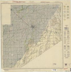
Printed with vegetation. Prepared by the U.S. Geological Survey for publication by the Defense Mapping Agency Hydrographic/Topographic Center. Variant tit...
Call Number:
G4090 s50 .U5 Saint Paul 1979 V
Caption:
Imprint: Reston, Virginia : Geological Survey, [1983] and Imprint: Washington, D.C. : Defense Mapping Agency, Hydrographic/Topographic Center, [1983]
Physical Description:
Dimensions: 56 x 45 cm or smaller and Scale: 1:50,000
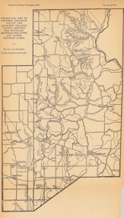
"Plate XVI." Detached from: A report on the geology of the middle and upper Silurian rocks of Clark, Jefferson, Ripley, Jennings and southern Decat...
Call Number:
G4093.R5C57 1896 .F6
Caption:
Imprint: [Indianapolis] : [Indiana Dept. of Geology and Natural Resources], [1897]
Physical Description:
Scale: Approximately 1:126,720. 2 miles = 1 inch and Dimensions: 41 x 27 cm
Alternate Identifier:
Alternate ID: 390726IP and Title Control Number: a17036513
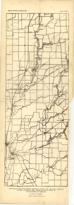
"Plate XVII." Detached from: A report on the geology of the middle and upper Silurian rocks of Clark, Jefferson, Ripley, Jennings and southern Deca...
Call Number:
G4093.J6C57 1896 .F6
Caption:
Imprint: [Indianapolis] : [Indiana Dept. of Geology and Natural Resources], [1897]
Physical Description:
Scale: Approximately 1:126,720. 2 miles to the in. and Dimensions: 34 x 13 cm
Alternate Identifier:
Alternate ID: 390726IP and Title Control Number: a18175777
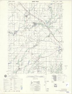
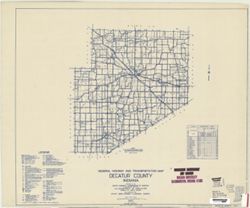
Geographic Subject: Decatur County (Ind.) and Topical Subject: Roads
Creator:
Indiana. State Highway Commission (1919-1953)
Publisher:
State Highway Commission of Indiana
Date Created:
1949
Identifier:
VAC3073-M-00697
Genre:
Road maps
Geographic Location:
Coordinates: W0854100 W0851800 N0392700 N0390800
Related URL:
Catalog URL: https://iucat.iu.edu/catalog/5704035
Abstract:
Blueline. "State roads revised to January 1, 1949." "Data obtained from Statewide Highway Planning Survey." Includes chart "Culture ...
Call Number:
G4093.D4P2 1949 .I53
Caption:
Imprint: [Indianapolis?] : State Highway Commission of Indiana. 1949.
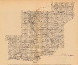
Title from caption. At head of title: Fig. 49B. Shows gravel locations. Detached from: The roads and road materials of a portion of southwestern Indiana /...
Call Number:
G4093.J6H5 1905 .I4
Caption:
Imprint: [Indianapolis] : [Indiana Dept. of Geology and Natural Resources], [1906]
Physical Description:
Scale: Approximately 1:410,000 and Dimensions: on sheet 22 x 26 cm
Alternate Identifier:
Title Control Number: a18299042 and Alternate ID: 390726IP
Geographic Subject: Franklin County (Ind.), Topical Subject: Geology, Topical Subject: IGS Annual Reports, and Geographic Subject: Decatur County (Ind.)
Creator:
Foerste, Aug. F. (Aug. Frederic), 1862-1936
Publisher:
Indiana. Department of Geology and Natural Resources
Plate XVII. "Report of State Geologist, 1897, plate xvii." Detached from: A report on the Niagara limestone quarries of Decatur, Franklin and...
Call Number:
G4093.F7C5 1897 .F64
Caption:
Imprint: [Indianapolis] : [Wm. B. Burford], [1898] and Imprint: [Indianapolis] : [Indiana Department of Geology and Natural Resources], [1898]
Physical Description:
Scale: Approximately 1:126,720. 2 miles = 1 inch and Dimensions: 25 x 15 cm
Alternate Identifier:
Title Control Number: a17227850 and Alternate ID: 390726IP
Shows shale locations, quarries, gas wells, schools, churches, and cemeteries. Detached from: A report upon the Waldron shale and its horizon ... / J.A. Pric...
Call Number:
G4091.C5 1899 .P7
Caption:
Imprint: Indianapolis : Indiana Dept. of Geology and Natural Resources, [1900] and Imprint: Indianapolis, Ind. : Wm. B. Burford, Lith., [1900]
Physical Description:
Dimensions: 40 x 33 cm and Scale: Approximately 1:126,720. 2 miles = 1 inch
Alternate Identifier:
Alternate ID: 390726IP and Title Control Number: a18272889
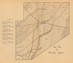
Detached from: A soil survey of Decatur, Jennings, Jefferson, Ripley, Dearborn, Ohio, and Switzerland counties, Indiana / L.C. Ward. In Indiana Dept. of Geol...
Call Number:
G4093.D4J3 1907 .S6
Caption:
Imprint: [Indianapolis] : [Indiana Department of Geology and Natural Resources], [1908]
Physical Description:
Dimensions: on sheet 23 x 26 cm and Scale: Scale not given.
Alternate Identifier:
Title Control Number: a18307561 and Alternate ID: 390726IP

![Map of the distribution of the Waldron shale in Decatur, Rush, Shelby, and Bartholomew counties, [Indiana]](https://iiif.uits.iu.edu/iiif/2/hh63tz71g%2Ffiles%2F9928330d-568f-4904-a59c-ed2846292533/full/250,/0/default.jpg)