
Search Constraints
You searched for:
Date Created
1932
Remove constraint Date Created: 1932
Collections
Indiana Historic Maps
Remove constraint Collections: Indiana Historic Maps
« Previous |
1 - 10 of 15
|
Next »
Search Results
-
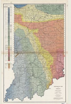
- Subject:
- Geographic Subject: Indiana and Topical Subject: Geology
- Creator:
- Indiana. Division of Geology
- Publisher:
- Indiana. Department of Conservation
- Date Created:
- 1932
- Identifier:
- VAC3073-M-00989
- Genre:
- Geological maps
- Geographic Location:
- Coordinates: W0870000 W0850000 N0410000 N0380000
- Related URL:
- Catalog URL: https://iucat.iu.edu/catalog/2849159
- Abstract:
- "Conservation Commission, Stanley Coulter, Chairman." "The based used...is the Ryse map, which has been modified." Includes geologic cros...
- Call Number:
- G4091.C5 1932 .I53
- Caption:
- Imprint: [Indianapolis] : Dept. of Conservation, State of Indiana, 1932.
- Physical Description:
- Dimensions: 177 x 112 cm and Scale: 1:253,440
- Alternate Identifier:
- Title Control Number: CAT7760BB
- Persistent URL:
- https://purl.dlib.indiana.edu/iudl/images/VAC3073/VAC3073-M-00989
-
![Michigan-Indiana Three Rivers quadrangle [1932 reprint]](https://iiif.uits.iu.edu/iiif/2/qb98nk04b%2Ffiles%2F296eac80-9a56-4522-add9-e4bc7783d601/full/250,/0/default.jpg)
- Subject:
- Geographic Subject: LaGrange County (Ind.), Geographic Subject: Saint Joseph County (Mich.), and Geographic Subject: Elkhart County (Ind.)
- Creator:
- Lee, L. L. (Luria Lyons), 1882-1962, Burney, H. E., U.S. Lake Survey, Herron, W. H. (William Harrison), 1865-, Geological Survey (U.S.), Marshall, R. B. (Rob...
- Publisher:
- Geological Survey (U.S.)
- Date Created:
- 1932
- Identifier:
- VAC3073-M-01396
- Genre:
- 15 minute topographic maps, Topographic maps, and Quadrangle maps
- Geographic Location:
- Coordinates: W0854500 W0853000 N0420000 N0414500
- Related URL:
- Catalog URL: https://iucat.iu.edu/catalog/18416001
- Abstract:
- R.B. Marshall, chief geographer , W.H. Herron, geographer in charge , topography by L.L. Lee and H.E. Burney , control by U.S. Lake Survey, J.R. Ellis, J.H. ...
- Call Number:
- G4090 s62 .G4 Three Rivers 1916 rep1932
- Caption:
- Imprint: Washington, D.C. : Dept. of the Interior, U.S. Geological Survey, 1932
- Physical Description:
- Scale: 1:62,500 and Dimensions: 45 x 42 cm or smaller
- Alternate Identifier:
- Title Control Number: a18416001
- Persistent URL:
- https://purl.dlib.indiana.edu/iudl/images/VAC3073/VAC3073-M-01396
- Provenance:
- Part of Geological Survey (U.S.). Indiana 1:62,500.
-
![Indiana Petersburg quadrangle [1932 reprint]](https://iiif.uits.iu.edu/iiif/2/1544cr675%2Ffiles%2F72561c8b-ac5e-45ad-a7cf-e47423b0d336/full/250,/0/default.jpg)
- Subject:
- Geographic Subject: Pike County (Ind.) and Geographic Subject: Gibson County (Ind.)
- Creator:
- Hawkins, Geo. T. (George T.), Geological Survey (U.S.), Blair, H. B. (Herbert Buxton), 1860-1905, McKinney, R. C. (Robert C.), and Renshawe, John H.
- Publisher:
- Geological Survey (U.S.)
- Date Created:
- 1932
- Identifier:
- VAC3073-M-01377
- Genre:
- Quadrangle maps, Topographic maps, and 15 minute topographic maps
- Geographic Location:
- Coordinates: W0873000 W0871500 N0383000 N0381500
- Related URL:
- Catalog URL: https://iucat.iu.edu/catalog/18408289
- Abstract:
- Engraved Nov. 1902 by U.S.G.S , Jno. H. Renshawe, geographer in charge, control by Geo. T. Hawkins, topography by R.C. McKinney and H.B. Blair. Relief shown ...
- Call Number:
- G4090 s62 .G4 Petersburg 1903 rep 1932
- Caption:
- Imprint: Washington, D.C. : U.S. Geological Survey, 1932
- Physical Description:
- Dimensions: 45 x 42 cm or smaller and Scale: 1:62,500
- Alternate Identifier:
- Title Control Number: a18408289
- Persistent URL:
- https://purl.dlib.indiana.edu/iudl/images/VAC3073/VAC3073-M-01377
- Provenance:
- Part of Geological Survey (U.S.). Indiana 1:62,500.
-
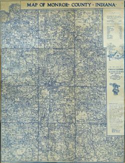
- Subject:
- Topical Subject: Real property, Geographic Subject: Monroe County (Ind.), and Topical Subject: Landowners
- Creator:
- Clevenger, Cyrus R.
- Publisher:
- Clevenger, Cyrus R.
- Date Created:
- 1932
- Identifier:
- VAC3073-M-01057
- Genre:
- Cadastral maps
- Geographic Location:
- Coordinates: W0864108 W0861902 N0392120 N0385926
- Related URL:
- Catalog URL: https://iucat.iu.edu/catalog/7455489
- Abstract:
- "Correct to February 15, 1932."
- Call Number:
- G4093.M7G46 1932 .C54
- Caption:
- Imprint: Bloomington, Ind. : Cyrus R. Clevenger, [1932]
- Physical Description:
- Scale: 1:47,000 and Dimensions: 87 x 70 cm, on sheet 115 x 73 cm
- Alternate Identifier:
- Title Control Number: a7455489
- Persistent URL:
- https://purl.dlib.indiana.edu/iudl/images/VAC3073/VAC3073-M-01057
-
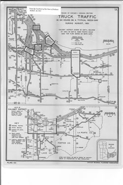
- Subject:
- Topical Subject: Trucks--Routes, Geographic Subject: Indiana, Northwest, Topical Subject: Traffic surveys, Geographic Subject: Chicago Region (Ill.), Geograp...
- Creator:
- Indiana. State Highway Commission (1919-1953) and Chicago Regional Planning Association
- Publisher:
- Indiana. Legislative Bureau
- Date Created:
- 1932
- Identifier:
- VAC3073-M-01055
- Genre:
- Statistical maps and Road maps
- Geographic Location:
- Coordinates: W0874204 W0862904 N0414539 N0411158
- Related URL:
- Catalog URL: https://iucat.iu.edu/catalog/18422835
- Abstract:
- 2 maps on one sheet. Shows truck traffic flow in the Calumet and greater Chicago Regions as well as the 1930 population of the cities and towns in the Calume...
- Call Number:
- G4102.C33P22 1931 .C4
- Caption:
- Imprint: [Indianapolis] : [Wm. B. Burford, contractor for state printing and binding], [1932] and Imprint: [Indianapolis] : [The Legislative Bureau], [1932]
- Physical Description:
- Scale: Approximately 1:50,000-1:115,000 and Dimensions: on sheet 40 x 30 cm
- Alternate Identifier:
- Title Control Number: a18422835 and Alternate ID: 397754IP
- Persistent URL:
- https://purl.dlib.indiana.edu/iudl/images/VAC3073/VAC3073-M-01055
- Provenance:
- Year book of the state of Indiana (1931)
-
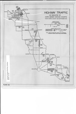
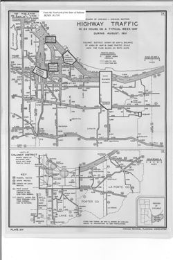
- Subject:
- Geographic Subject: Indiana and Topical Subject: Traffic surveys
- Creator:
- Indiana. State Highway Commission (1919-1953)
- Publisher:
- Indiana. Legislative Bureau
- Date Created:
- 1932
- Identifier:
- VAC3073-M-01054
- Genre:
- Road maps and Statistical maps
- Geographic Location:
- Coordinates: W0873100 W0844800 N0414500 N0392100
- Related URL:
- Catalog URL: https://iucat.iu.edu/catalog/18422724
- Abstract:
- Shows traffic in 24 hours on a typical week day, Sunday, and Labor Day. "Plate XIII." Detached from: Report of the Indiana State Highway Commiss...
- Call Number:
- G4091.P21 1931 .H5
- Caption:
- Imprint: [Indianapolis] : [Wm. B. Burford, contractor for state printing and binding], [1932] and Imprint: [Indianapolis] : [The Legislative Bureau], [1932]
- Physical Description:
- Dimensions: on sheet 40 x 30 cm and Scale: Scale not given.
- Alternate Identifier:
- Title Control Number: a18422724 and Alternate ID: 397754IP
- Persistent URL:
- https://purl.dlib.indiana.edu/iudl/images/VAC3073/VAC3073-M-01054
- Provenance:
- Year book of the state of Indiana (1931)
-
- Subject:
- Geographic Subject: Calumet Region (Ill. and Ind.), Geographic Subject: Indiana, Northwest, Topical Subject: Traffic surveys, Topical Subject: Metropolitan a...
- Creator:
- Indiana. State Highway Commission (1919-1953) and Chicago Regional Planning Association
- Publisher:
- Indiana. Legislative Bureau
- Date Created:
- 1932
- Identifier:
- VAC3073-M-01053
- Genre:
- Road maps and Statistical maps
- Geographic Location:
- Coordinates: W0874204 W0862904 N0414539 N0411158
- Related URL:
- Catalog URL: https://iucat.iu.edu/catalog/18422708
- Abstract:
- 2 maps on one sheet. Shows traffic flow in the Calumet and greater Chicago Regions as well as the 1930 population of the cities and towns in the Calumet Regi...
- Call Number:
- G4102.C33P21 1931 .C4
- Caption:
- Imprint: [Indianapolis] : [Wm. B. Burford, contractor for state printing and binding], [1932] and Imprint: [Indianapolis] : [The Legislative Bureau], [1932]
- Physical Description:
- Dimensions: on sheet 40 x 30 cm and Scale: Approximately 1:50,000-1:115,000
- Alternate Identifier:
- Title Control Number: a18422708 and Alternate ID: 397754IP
- Persistent URL:
- https://purl.dlib.indiana.edu/iudl/images/VAC3073/VAC3073-M-01053
- Provenance:
- Year book of the state of Indiana (1931)
-
![State highways in the federal aid system as of September 30, 1931 [Indiana]](https://iiif.uits.iu.edu/iiif/2/sf269861n%2Ffiles%2F76f20d74-1e0f-4901-83eb-f2dbe49e6f3b/full/250,/0/default.jpg)
- Subject:
- Geographic Subject: Indiana, Topical Subject: Roads, and Topical Subject: Federal aid to transportation
- Creator:
- Indiana. State Highway Commission (1919-1953)
- Publisher:
- Indiana. Legislative Bureau
- Date Created:
- 1932
- Identifier:
- VAC3073-M-01048
- Genre:
- Road maps
- Geographic Location:
- Coordinates: W0880500 W0844700 N0414500 N0374600
- Related URL:
- Catalog URL: https://iucat.iu.edu/catalog/18422833
- Abstract:
- Detached from: Report of the Indiana State Highway Commission for the fiscal year ending September 30, 1931 / State Highway Commission. In Year book of the S...
- Call Number:
- G4091.P2 1931 .S7
- Caption:
- Imprint: [Indianapolis] : [Wm. B. Burford, contractor for state printing and binding], [1932] and Imprint: [Indianapolis] : [The Legislative Bureau], [1932]
- Physical Description:
- Scale: Scale not given. and Dimensions: 34 x 23 cm, on sheet 35 x 25 cm
- Alternate Identifier:
- Alternate ID: 397754IP and Title Control Number: a18422833
- Persistent URL:
- https://purl.dlib.indiana.edu/iudl/images/VAC3073/VAC3073-M-01048
- Provenance:
- Year book of the state of Indiana (1931)
-
- Subject:
- Topical Subject: Traffic fatalities, Topical Subject: Roads, and Geographic Subject: Indiana
- Publisher:
- Indiana. Legislative Bureau
- Date Created:
- 1932
- Identifier:
- VAC3073-M-01045
- Genre:
- Road maps
- Geographic Location:
- Coordinates: W0880500 W0844700 N0414500 N0374600
- Related URL:
- Catalog URL: https://iucat.iu.edu/catalog/18422775
- Abstract:
- Shows the approximate locations of traffic fatalities. "Plate V." Detached from: Report of the Indiana State Highway Commission for the fiscal y...
- Call Number:
- G4091.P21 1930 .F3
- Caption:
- Imprint: [Indianapolis] : [Wm. B. Burford, contractor for state printing and binding], [1932] and Imprint: [Indianapolis] : [The Legislative Bureau], [1932]
- Physical Description:
- Scale: Scale not given. and Dimensions: 16 x 11 cm, on sheet 23 x 15 cm
- Alternate Identifier:
- Alternate ID: 397754IP and Title Control Number: a18422775
- Persistent URL:
- https://purl.dlib.indiana.edu/iudl/images/VAC3073/VAC3073-M-01045
- Provenance:
- Year book of the state of Indiana (1931)
-
![State Highway System of Indiana [1931]](https://iiif.uits.iu.edu/iiif/2/37721h103%2Ffiles%2Ffa05ffc3-ea08-47a1-a0e9-3fd32b013a08/full/250,/0/default.jpg)
- Subject:
- Topical Subject: Roads, Geographic Subject: Indiana, and Topical Subject: Road materials
- Creator:
- Indiana. State Highway Commission (1919-1953)
- Publisher:
- Indiana. Legislative Bureau
- Date Created:
- 1932
- Identifier:
- VAC3073-M-01043
- Genre:
- Road maps
- Geographic Location:
- Coordinates: W0880500 W0844700 N0414500 N0374600
- Related URL:
- Catalog URL: https://iucat.iu.edu/catalog/18422777
- Abstract:
- Shows roads by surface and composition type as well as standard Indiana road signs and the locations of state parks, state owned property, bodies of water, p...
- Call Number:
- G4091.P2 1931 .I5
- Caption:
- Imprint: [Indianapolis] : [The Legislative Bureau], [1932] and Imprint: [Indianapolis] : [Wm. B. Burford, contractor for state printing and binding], [1932]
- Physical Description:
- Dimensions: 41 x 27 cm, on sheet 44 x 29 cm and Scale: Approximately 1:1,250,000
- Alternate Identifier:
- Title Control Number: a18422777 and Alternate ID: 397754IP
- Persistent URL:
- https://purl.dlib.indiana.edu/iudl/images/VAC3073/VAC3073-M-01043
- Provenance:
- Year book of the state of Indiana (1931)
