
Search Constraints
You searched for:
Date Created
1930
Remove constraint Date Created: 1930
Collections
Indiana Historic Maps
Remove constraint Collections: Indiana Historic Maps
1 - 10 of 10
Search Results
-
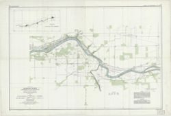
- Subject:
- Topical Subject: Rivers, Topical Subject: Valleys, Geographic Subject: Wabash River, and Geographic Subject: Wabash River Valley
- Creator:
- Williams & Heintz Co.
- Publisher:
- United States. Army. Corps of Engineers. Louisville District.
- Date Created:
- 1930
- Identifier:
- VAC3073-M-01501
- Genre:
- Nautical charts
- Geographic Location:
- Coordinates: W0880700 W0843300 N0405700 N0374700
- Related URL:
- Catalog URL: https://iucat.iu.edu/catalog/6799690
- Abstract:
- Surveyed and mapped under the direction of the United States engineer officer, Louisville, Ky. 1930. Relief shown by contours and spot heights. Depths sho...
- Call Number:
- G4072.W3 1930 .U5
- Caption:
- Imprint: Washington, D.C. : Williams & Heintz Co., 1931.
- Physical Description:
- Scale: 1:24,000 and Dimensions: 64 x 96 cm, on sheets 72 x 107 cm
- Persistent URL:
- https://purl.dlib.indiana.edu/iudl/images/VAC3073/VAC3073-M-01501
-
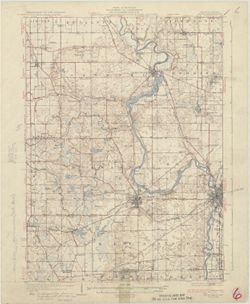
![Michigan-Indiana Three Oaks quadrangle [1930 printing]](https://iiif.uits.iu.edu/iiif/2/s1785q22x%2Ffiles%2Fdf050288-4fd9-4056-bb9e-e2b44d32511e/full/250,/0/default.jpg)
- Subject:
- Geographic Subject: Saint Joseph County (Ind.), Geographic Subject: Berrien County (Mich.), and Geographic Subject: LaPorte County (Ind.)
- Creator:
- Geological Survey (U.S.), Michigan. Geological Survey Division, Plushnick, A. W. (Andrew Winfield), 1898-1980, Gehres, W. S. (Wilmer Sherman), 1887-1963, and...
- Publisher:
- Geological Survey (U.S.)
- Date Created:
- 1930
- Identifier:
- VAC3073-M-01395
- Genre:
- Topographic maps, 15 minute topographic maps, and Quadrangle maps
- Geographic Location:
- Coordinates: W0865000 W0863000 N0420000 N0414500
- Related URL:
- Catalog URL: https://iucat.iu.edu/catalog/18413989
- Abstract:
- Topography by W.S. Gehres and A.W. Plushnick , culture and drainage in part compiled from aerial photographs taken by Air Corps, U.S. Army , control by U.S. ...
- Call Number:
- G4090 s62 .G4 Three Oaks 1930
- Caption:
- Imprint: Washington, D.C. : U.S. Geological Survey, [1930]
- Physical Description:
- Scale: 1:62,500 and Dimensions: 45 x 42 cm or smaller
- Alternate Identifier:
- Title Control Number: a18413989
- Persistent URL:
- https://purl.dlib.indiana.edu/iudl/images/VAC3073/VAC3073-M-01395
- Provenance:
- Part of Geological Survey (U.S.). Indiana 1:62,500.
-
- Subject:
- Geographic Subject: Berrien County (Mich.) and Geographic Subject: Saint Joseph County (Ind.)
- Creator:
- Gehres, W. S. (Wilmer Sherman), 1887-1963, Geological Survey (U.S.), Plushnick, A. W. (Andrew Winfield), 1898-1980, U.S. Lake Survey, Michigan. Geological Su...
- Publisher:
- Geological Survey (U.S.)
- Date Created:
- 1930
- Identifier:
- VAC3073-M-01363
- Genre:
- 15 minute topographic maps, Quadrangle maps, and Topographic maps
- Geographic Location:
- Coordinates: W0863000 W0861500 N0420000 N0414500
- Related URL:
- Catalog URL: https://iucat.iu.edu/catalog/18413855
- Abstract:
- Topography by W.S. Gehres and A.W. Plushnick. Filing title: Niles, Mich.-Ind. Edition of 1930. Polyconic projection. Relief shown by contours and spot height...
- Call Number:
- G4090 s62 .G4 Niles 1930
- Caption:
- Imprint: Washington, D.C. : Dept. of the Interior, U.S. Geological Survey, 1930
- Physical Description:
- Dimensions: 45 x 42 cm or smaller and Scale: 1:62,500
- Alternate Identifier:
- Title Control Number: a18413855
- Persistent URL:
- https://purl.dlib.indiana.edu/iudl/images/VAC3073/VAC3073-M-01363
- Provenance:
- Part of Geological Survey (U.S.). Indiana 1:62,500.
-
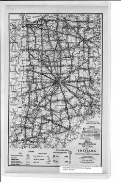
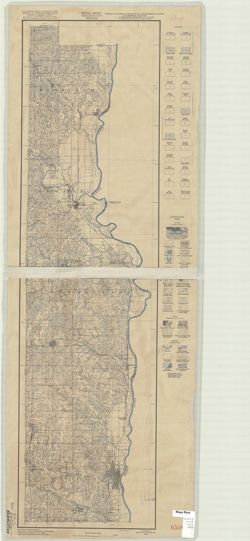
- Subject:
- Topical Subject: Road materials, Geographic Subject: Indiana, Topical Subject: Roads, and Topical Subject: Administrative and political divisions
- Creator:
- Indiana. State Highway Commission (1919-1953)
- Publisher:
- Indiana. Legislative Bureau
- Date Created:
- 1930
- Identifier:
- VAC3073-M-01041
- Genre:
- Road maps
- Geographic Location:
- Coordinates: W0880500 W0844700 N0414500 N0374600
- Related URL:
- Catalog URL: https://iucat.iu.edu/catalog/18455618
- Abstract:
- Caption title: Sub-district & road section map. Shows roads by surface and composition type as well as official highway markers, boundaries and headquart...
- Call Number:
- G4091.P2 1929 .I5
- Caption:
- Imprint: [Indianapolis] : [Wm. B. Burford, contractor for state printing and binding], [1930] and Imprint: [Indianapolis] : [The Legislative Bureau], [1930]
- Physical Description:
- Scale: Approximately 1:1,370,000 and Dimensions: 38 x 23 cm, on sheet 43 x 26 cm
- Alternate Identifier:
- Alternate ID: 397754IP and Title Control Number: a18455618
- Persistent URL:
- https://purl.dlib.indiana.edu/iudl/images/VAC3073/VAC3073-M-01041
- Provenance:
- State Highway System of Indiana.
-
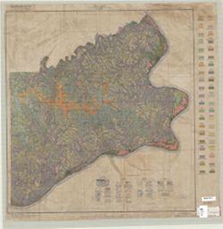
- Subject:
- Geographic Subject: Switzerland County (Ind.), Topical Subject: Classification, Geographic Subject: Ohio County (Ind.), and Topical Subject: Soils
- Creator:
- Hendrickson, B. H. (Bertram Higbie), 1892-
- Publisher:
- United States. Bureau of Soils
- Date Created:
- 1930
- Identifier:
- VAC3073-M-00959
- Genre:
- Thematic maps
- Geographic Location:
- Coordinates: W0851200 W0844700 N0390200 N0384200
- Related URL:
- Catalog URL: https://iucat.iu.edu/catalog/2873819
- Abstract:
- Shows soil types classification by colors and symbols. "Field Operations, Bureau of Chemistry and Soils, 1930." "Lith Eastern Offset Inc., Bal...
- Call Number:
- G4093 .O3J3 1930 .H46
- Caption:
- Imprint: [Washington, D.C.?] : The Bureau, 1930.
- Physical Description:
- Dimensions: 63 x 53 cm and Scale: 1:63,360
- Alternate Identifier:
- Title Control Number: CAY9806BB
- Persistent URL:
- https://purl.dlib.indiana.edu/iudl/images/VAC3073/VAC3073-M-00959
-
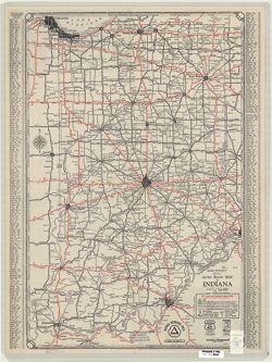
- Subject:
- Topical Subject: Roads and Geographic Subject: Indiana
- Creator:
- Rand McNally and Company
- Publisher:
- Rand McNally and Company
- Date Created:
- 1930
- Identifier:
- VAC3073-M-00774
- Genre:
- Road maps
- Geographic Location:
- Coordinates: W0880500 W0844700 N0414500 N0374600
- Related URL:
- Catalog URL: https://iucat.iu.edu/catalog/5273354
- Abstract:
- Includes "Index to cities & towns with populations." "Cities Service mileage chart" and "Cities Service road map North-Central S...
- Call Number:
- G4091.P2 1930 .R3
- Caption:
- Imprint: Chicago : Rand McNally, [1930]
- Physical Description:
- Scale: 1:800,000 and Dimensions: 58 x 38 cm
- Alternate Identifier:
- Title Control Number: a5273354
- Persistent URL:
- https://purl.dlib.indiana.edu/iudl/images/VAC3073/VAC3073-M-00774
-
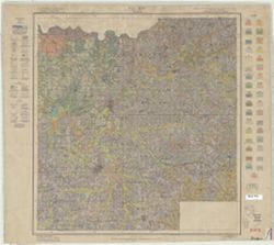
- Subject:
- Geographic Subject: Dubois County (Ind.), Topical Subject: Soils, and Topical Subject: Classification
- Creator:
- Simmons, C. S. (Charles Shaffer), 1900-
- Publisher:
- United States. Bureau of Chemistry and Soils
- Date Created:
- 1930
- Identifier:
- VAC3073-M-00729
- Genre:
- Thematic maps
- Geographic Location:
- Coordinates: W0870400 W0864100 N0383200 N0381200
- Related URL:
- Catalog URL: https://iucat.iu.edu/catalog/2867189
- Abstract:
- Shows soil types classification by colors and symbols. "Field operations Bureau of Chemistry and Soils 1930. "Williams & Heintz Co. Wash. D.C.&...
- Call Number:
- G4093 .D8J3 1930 .S56
- Caption:
- Imprint: [Washington, D.C.] : Bureau of Soils, 1930?
- Physical Description:
- Scale: 1:63,360 and Dimensions: 57 x 54 cm
- Alternate Identifier:
- Title Control Number: CAX5064BB
- Persistent URL:
- https://purl.dlib.indiana.edu/iudl/images/VAC3073/VAC3073-M-00729
-
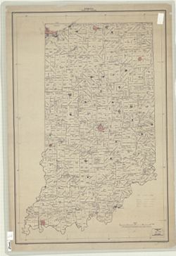
- Subject:
- Geographic Subject: Indiana and Topical Subject: Administrative and political divisions
- Creator:
- United States. Bureau of the Census
- Publisher:
- United States. Government Printing Office
- Date Created:
- 1930
- Identifier:
- VAC3073-M-00430
- Genre:
- Thematic maps
- Geographic Location:
- Coordinates: W0880700 W0844500 N0414500 N0375200
- Related URL:
- Catalog URL: https://iucat.iu.edu/catalog/2253095
- Abstract:
- "Bureau of the Census--1930."
- Call Number:
- G4091 .F7 1930 .U5
- Caption:
- Imprint: Washington, D.C. : U.S. G.P.O., 1930.
- Physical Description:
- Scale: 1:500,000 and Dimensions: 93 x 61 cm
- Alternate Identifier:
- Title Control Number: BGX8889BB
- Persistent URL:
- https://purl.dlib.indiana.edu/iudl/images/VAC3073/VAC3073-M-00430
-
- Subject:
- Topical Subject: Classification, Geographic Subject: Vermillion County (Ind.), and Topical Subject: Soils
- Creator:
- Buckhannan, W. H. (William Henry), 1901-
- Publisher:
- United States. Bureau of Soils
- Date Created:
- 1930
- Identifier:
- VAC3073-M-00220
- Genre:
- Thematic maps
- Geographic Location:
- Coordinates: W0873200 W0872300 N0400900 N0393700
- Related URL:
- Catalog URL: https://iucat.iu.edu/catalog/2874422
- Abstract:
- Shows soil types classification by colors and symbols. "Field Operations, Bureau of Chemistry and Soils." "Lith. A. Hoen & co., Inc."
- Call Number:
- G4093 .V4J3 1930 .B83
- Caption:
- Imprint: [Washington, D.C.?] : Bureau of Soils, [1930?]
- Physical Description:
- Dimensions: 94 x 25 cm and Scale: 1:63,360
- Alternate Identifier:
- Title Control Number: CAZ0941BB
- Persistent URL:
- https://purl.dlib.indiana.edu/iudl/images/VAC3073/VAC3073-M-00220
-
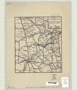
- Subject:
- Geographic Subject: Kentucky, Topical Subject: Roads, and Geographic Subject: Indiana
- Creator:
- Ragsdale, I.H., (Ira Haven)
- Publisher:
- Ragsdale, I. H. (Ira Haven)
- Date Created:
- 1930
- Identifier:
- VAC3073-M-00126
- Genre:
- Road maps
- Geographic Location:
- Coordinates: W0861547 W0843029 N0393235 N0375834
- Related URL:
- Catalog URL: https://iucat.iu.edu/catalog/7323766
- Call Number:
- G4091.P2 1930 .R34
- Caption:
- Imprint: [Greenwood, Ill. : I.H. Ragsdale, [1930]
- Physical Description:
- Scale: Scale not given. and Dimensions: 20 x 17 cm
- Alternate Identifier:
- Title Control Number: a7323766
- Persistent URL:
- https://purl.dlib.indiana.edu/iudl/images/VAC3073/VAC3073-M-00126
