
Search Constraints
You searched for:
Date Created
1932
Remove constraint Date Created: 1932
State/Province
Украинская ССР (Ukrainian Soviet Socialist Republic)
Remove constraint State/Province: Украинская ССР (Ukrainian Soviet Socialist Republic)
« Previous |
1 - 10 of 31
|
Next »
Search Results
-
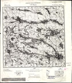
- Description:
- 1914
- Subject:
- Geographic Subject: Podilsk, Topical Subject: Maps, and Topical Subject: Soviet Union
- Publisher:
- Управление военных топографов РККА
- Language:
- Russian
- Date Created:
- 1932
- Identifier:
- VAC9619-001507
- Genre:
- Topographic Maps and Military Maps
- Geographic Location:
- Coordinates: 47.6667, 29.5, 48, 30
- Related URL:
- Download GeoTIFF: https://drive.google.com/file/d/1yoB4gIhyBxqMxVG2YSUt4dy0IT4GLUCb/view?usp=sharing and Catalog URL: https://iucat.iu.edu/catalog/5020129
- Abstract:
- Modern area represented: Podilsk, Odessa oblast, Ukraine
- Call Number:
- G7000 s100 .S7 sheet L-35-12
- Caption:
- Не подлежит оглашению
- City:
- Котовск (Kotovsk)
- Copyright Holder:
- No Copyright - United States
- Country:
- СССР (USSR)
- State/Province:
- Украинская ССР (Ukrainian Soviet Socialist Republic), Одесская область (Odessa oblast), and Молдавская АССР (Moldavian Autonomous Soviet Socialist Republic)
- Physical Description:
- Scale: 1:100,000
- Persistent URL:
- http://purl.dlib.indiana.edu/iudl/images/VAC9619/VAC9619-001507
- Provenance:
- DMA Topographic Center, Army Map Service Library, OMAHA, Library of Congress Geography & Map Division, Auswärtiges Amt. Geographischer Dienst
-
- Description:
- 1914
- Subject:
- Topical Subject: Maps, Topical Subject: Soviet Union, and Geographic Subject: Podilsk
- Publisher:
- Управление военных топографов РККА
- Language:
- Russian
- Date Created:
- 1932
- Identifier:
- VAC9619-001503
- Genre:
- Topographic Maps and Military Maps
- Geographic Location:
- Coordinates: 47.6667, 29.5, 48, 30
- Related URL:
- Catalog URL: https://iucat.iu.edu/catalog/5020129 and Download GeoTIFF: https://drive.google.com/open?id=1GY1T_2cRAKuBJomRz9ZEfhqJTuF0vfG8
- Abstract:
- Modern area represented: Podilsk, Odessa oblast, Ukraine
- Call Number:
- G7000 s100 .S7 sheet L-35-12
- Caption:
- Не подлежит оглашению
- City:
- Котовск (Kotovsk)
- Copyright Holder:
- No Copyright - United States
- Country:
- СССР (USSR)
- State/Province:
- Одесская область (Odessa oblast), Украинская ССР (Ukrainian Soviet Socialist Republic), and Молдавская АССР (Moldavian Autonomous Soviet Socialist Republic)
- Physical Description:
- Scale: 1:100,000
- Persistent URL:
- http://purl.dlib.indiana.edu/iudl/images/VAC9619/VAC9619-001503
- Provenance:
- CIA Map Library, Auswärtiges Amt. Geographischer Dienst
-
- Description:
- 1929
- Subject:
- Geographic Subject: Zhornokl'ovy, Topical Subject: Maps, and Topical Subject: Soviet Union
- Publisher:
- Управление военных топографов
- Language:
- Russian
- Date Created:
- 1932
- Identifier:
- VAC9619-000991
- Genre:
- Military Maps and Topographic Maps
- Geographic Location:
- Coordinates: 49.833, 31.75, 50, 32
- Related URL:
- Download GeoTIFF: https://drive.google.com/open?id=16Nggj2nwfnBGW6Q4EWeXn7a7Sap0bRb1 and Catalog URL: http://iucat.iu.edu/catalog/5020131
- Abstract:
- Modern area represented: Жорнокльови (Zhornokl'ovy), Cherkasy oblast, Ukraine
- Call Number:
- G7000 s50 .S68 sheet M-36-76-B
- Caption:
- Captured map, Рассекречено, and Не подлежит оглашению (crossed out)
- City:
- Жорноклевы (Zhornoklevy)
- Copyright Holder:
- No Copyright - United States
- Country:
- СССР (USSR)
- State/Province:
- Украинская ССР (Ukrainian Soviet Socialist Republic)
- Physical Description:
- Scale: 1:50,000
- Persistent URL:
- http://purl.dlib.indiana.edu/iudl/images/VAC9619/VAC9619-000991
- Provenance:
- DMA Topographic Center, Army Map Service Library, OMAHA, Library of Congress Geography & Map Division
-
- Description:
- 1923
- Subject:
- Geographic Subject: Rokytne, Topical Subject: Soviet Union, and Topical Subject: Maps
- Publisher:
- Управление военных топографов
- Language:
- Russian
- Date Created:
- 1932
- Identifier:
- VAC9619-000985
- Genre:
- Topographic Maps and Military Maps
- Geographic Location:
- Coordinates: 49.667, 30.25, 49.833, 30.5
- Related URL:
- Download GeoTIFF: https://drive.google.com/open?id=1iaJ6KvA1GY4Z2A2qK0P_HfIVJmnZmYhW and Catalog URL: http://iucat.iu.edu/catalog/5020131
- Abstract:
- Modern area represented: Рокитне (Rokytne), Kyiv oblast, Ukraine
- Call Number:
- G7000 s50 .S68 sheet M-36-73-D
- Caption:
- Не подлежит оглашению
- City:
- Рокитно (Rokitno)
- Copyright Holder:
- No Copyright - United States
- Country:
- СССР (USSR)
- State/Province:
- Украинская ССР (Ukrainian Soviet Socialist Republic) and Киевская область (Kyiv oblast)
- Physical Description:
- Scale: 1:50,000
- Persistent URL:
- http://purl.dlib.indiana.edu/iudl/images/VAC9619/VAC9619-000985
- Provenance:
- DMA Topographic Center, Army Map Service Library, OMAHA, Library of Congress Geography & Map Division
-
- Description:
- 1924
- Subject:
- Topical Subject: Soviet Union, Geographic Subject: Остер (Oster), and Topical Subject: Maps
- Publisher:
- Управление военных топографов
- Language:
- Russian
- Date Created:
- 1932
- Identifier:
- VAC9619-000942
- Genre:
- Topographic Maps and Military Maps
- Geographic Location:
- Coordinates: 50.833, 30.75, 51, 31
- Related URL:
- Download GeoTIFF: https://drive.google.com/open?id=11GQzIsGUFzpSJcPMQzAjvEbiIarAoUrD and Catalog URL: http://iucat.iu.edu/catalog/5020131
- Abstract:
- Modern area represented: Остер (Oster), Chernihiv oblast, Ukraine
- Call Number:
- G7000 s50 .S68 sheet M-36-38-B
- Caption:
- Не подлежит оглашению
- City:
- Остер (Oster)
- Copyright Holder:
- No Copyright - United States
- Country:
- СССР (USSR)
- State/Province:
- Киевская область (Kyiv oblast) and Украинская ССР (Ukrainian Soviet Socialist Republic)
- Physical Description:
- Scale: 1:50,000
- Persistent URL:
- http://purl.dlib.indiana.edu/iudl/images/VAC9619/VAC9619-000942
- Provenance:
- DMA Topographic Center, Army Map Service Library, OMAHA, Library of Congress Geography & Map Division
-
- Description:
- 1923
- Subject:
- Topical Subject: Maps, Topical Subject: Soviet Union, and Geographic Subject: Obukhiv
- Publisher:
- Генеральный штаб РККА
- Language:
- Russian
- Date Created:
- 1932
- Identifier:
- VAC9619-003292
- Genre:
- Topographic Maps and Military Maps
- Geographic Location:
- Coordinates: 50, 30.5, 50.333, 31
- Related URL:
- Download GeoTIFF: https://drive.google.com/file/d/1IKU5S1he-loKUI7NMcg8yD1GeraYdNob/view?usp=sharing and Catalog URL: https://iucat.iu.edu/catalog/5020129
- Abstract:
- Modern area represented: Obukhiv, Kiev oblast, Ukraine
- Call Number:
- G7000 s100 .S7 sheet M-36-62
- Caption:
- Для служебного пользования
- City:
- Обухов (Obukhiv)
- Copyright Holder:
- No Copyright - United States
- Country:
- СССР (USSR)
- State/Province:
- Киевская область (Kyiv oblast) and Украинская ССР (Ukrainian Soviet Socialist Republic)
- Physical Description:
- Scale: 1:100,000
- Persistent URL:
- http://purl.dlib.indiana.edu/iudl/images/VAC9619/VAC9619-003292
- Provenance:
- DMA Topographic Center, Army Map Service Library, OMAHA, Library of Congress Geography & Map Division
-
- Description:
- 1923
- Subject:
- Topical Subject: Maps, Geographic Subject: Kyiv, and Topical Subject: Soviet Union
- Publisher:
- Генеральный штаб РККА
- Language:
- Russian
- Date Created:
- 1932
- Identifier:
- VAC9619-003286
- Genre:
- Topographic Maps and Military Maps
- Geographic Location:
- Coordinates: 50.333, 30.5, 50.677, 31
- Related URL:
- Download GeoTIFF: https://drive.google.com/file/d/1DGA-b_UurA7XoNZ1lMQZB1-jBymVNuhJ/view?usp=sharing and Catalog URL: https://iucat.iu.edu/catalog/5020129
- Abstract:
- Modern area represented: Kyiv, Kiev oblast, Ukraine
- Call Number:
- G7000 s100 .S7 sheet M-36-50
- Caption:
- Для служебного пользования
- City:
- Киев (Kyiv)
- Copyright Holder:
- No Copyright - United States
- Country:
- СССР (USSR)
- State/Province:
- Киевская область (Kyiv oblast) and Украинская ССР (Ukrainian Soviet Socialist Republic)
- Physical Description:
- Scale: 1:100,000
- Persistent URL:
- http://purl.dlib.indiana.edu/iudl/images/VAC9619/VAC9619-003286
- Provenance:
- DMA Topographic Center, Army Map Service Library, OMAHA, Library of Congress Geography & Map Division
-
- Description:
- 1929
- Subject:
- Topical Subject: Maps, Topical Subject: Soviet Union, and Geographic Subject: Chornobyl
- Publisher:
- Генеральный штаб РККА
- Language:
- Russian
- Date Created:
- 1932
- Identifier:
- VAC9619-003270
- Genre:
- Military Maps and Topographic Maps
- Geographic Location:
- Coordinates: 51, 30, 51.333, 30.5
- Related URL:
- Catalog URL: https://iucat.iu.edu/catalog/5020129 and Download GeoTIFF: https://drive.google.com/file/d/1yIQsvVJLXuA-9oO1lvbl2PPyyofDIkua/view?usp=sharing
- Abstract:
- Modern area represented: Chornobyl, Kiev oblast, Ukraine
- Call Number:
- G7000 s100 .S7 sheet M-36-25
- Caption:
- Не подлежит оглашению
- City:
- Чернобыль (Chornobyl)
- Copyright Holder:
- No Copyright - United States
- Country:
- СССР (USSR)
- State/Province:
- Украинская ССР (Ukrainian Soviet Socialist Republic), Черниговская область (Chernihiv oblast), Полесская область (Polesia oblast), Белорусская ССР (Byeloruss...
- Physical Description:
- Scale: 1:100,000
- Persistent URL:
- http://purl.dlib.indiana.edu/iudl/images/VAC9619/VAC9619-003270
- Provenance:
- DMA Topographic Center, Army Map Service Library, OMAHA, Library of Congress Geography & Map Division
-
- Description:
- 1910
- Subject:
- Topical Subject: Maps, Geographic Subject: Khrystynivka, and Topical Subject: Soviet Union
- Publisher:
- Управление военных топографов РККА
- Language:
- Russian
- Date Created:
- 1932
- Identifier:
- VAC9619-003244
- Genre:
- Topographic Maps and Military Maps
- Geographic Location:
- Coordinates: 48.667, 29.5, 49, 30
- Related URL:
- Catalog URL: https://iucat.iu.edu/catalog/5020129 and Download GeoTIFF: https://drive.google.com/file/d/18XiPWIGh6qpclep03S-jZjfpBuTFbG9-/view?usp=sharing
- Abstract:
- Modern area represented: Khrystynivka, Cherkasy oblast, Ukraine
- Call Number:
- G7000 s100 .S7 sheet M-35-120
- Caption:
- Не подлежит оглашению
- City:
- Христинивка (Khrystynivka)
- Copyright Holder:
- No Copyright - United States
- Country:
- СССР (USSR)
- State/Province:
- Украинская ССР (Ukrainian Soviet Socialist Republic), Винницкая область (Vinnytsia oblast), and Киевская область (Kyiv oblast)
- Physical Description:
- Scale: 1:100,000
- Persistent URL:
- http://purl.dlib.indiana.edu/iudl/images/VAC9619/VAC9619-003244
- Provenance:
- DMA Topographic Center, Army Map Service Library, Library of Congress Geography & Map Division, Atlasblatt
-
- Description:
- 1908
- Subject:
- Topical Subject: Soviet Union, Topical Subject: Maps, and Geographic Subject: Pohrebyshche
- Publisher:
- Управление военных топографов РККА
- Language:
- Russian
- Date Created:
- 1932
- Identifier:
- VAC9619-003238
- Genre:
- Topographic Maps and Military Maps
- Geographic Location:
- Coordinates: 49.333, 29, 49.667, 29.5
- Related URL:
- Download GeoTIFF: https://drive.google.com/file/d/1GHx_mmI5hvqTaOEWVpNlw-qSYlmo67I7/view?usp=sharing and Catalog URL: https://iucat.iu.edu/catalog/5020129
- Abstract:
- Modern area represented: Pohrebyshche, Vinnytsia oblast, Ukraine
- Call Number:
- G7000 s100 .S7 sheet M-35-95
- Caption:
- Не подлежит оглашению
- City:
- Погребище (Pohrebyshche)
- Copyright Holder:
- No Copyright - United States
- Country:
- СССР (USSR)
- State/Province:
- Житомирская область (Zhytomyr oblast), Украинская ССР (Ukrainian Soviet Socialist Republic), and Винницкая область (Vinnytsia oblast)
- Physical Description:
- Scale: 1:100,000
- Persistent URL:
- http://purl.dlib.indiana.edu/iudl/images/VAC9619/VAC9619-003238
- Provenance:
- DMA Topographic Center, Army Map Service Library, OMAHA, Atlasblatt

- « Previous
- Next »
- 1
- 2
- 3
- 4