
Search Constraints
You searched for:
Publisher
Управление военных топографов
Remove constraint Publisher: Управление военных топографов
State/Province
Украинская ССР (Ukrainian Soviet Socialist Republic)
Remove constraint State/Province: Украинская ССР (Ukrainian Soviet Socialist Republic)
« Previous |
1 - 10 of 150
|
Next »
Search Results
-
- Description:
- 1930
- Subject:
- Topical Subject: Maps, Topical Subject: Soviet Union, and Geographic Subject: Kamenskiy Khutor
- Publisher:
- Управление военных топографов
- Language:
- Russian
- Identifier:
- VAC9619-001580
- Genre:
- Topographic Maps and Military Maps
- Geographic Location:
- Coordinates: 52, 32.25, 52.1667, 32.5
- Related URL:
- Catalog URL: http://iucat.iu.edu/catalog/5020131 and Download GeoTIFF: https://drive.google.com/open?id=1F40ViE0yDvGViIOC-bOSCTmjsYKUPP0M
- Abstract:
- Modern area represented: Kamenskiy Khutor, Bryansk oblast, Russia
- Call Number:
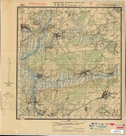
- G7000 s50 .S68 sheet N-36-137-D
- Caption:
- Не подлежит оглашению
- City:
- Каменский Хутор (Kamenskiy Khutor)
- Copyright Holder:
- No Copyright - United States
- Country:
- СССР (USSR)
- State/Province:
- Западная область (Western oblast), РСФСР (RSFSR), and Украинская ССР (Ukrainian Soviet Socialist Republic)
- Physical Description:
- Scale: 1:50,000
- Persistent URL:
- http://purl.dlib.indiana.edu/iudl/images/VAC9619/VAC9619-001580
- Provenance:
- M. I. Map Library, Atlasblatt
-
- Description:
- 1930
- Subject:
- Topical Subject: Maps, Geographic Subject: Novyy Ropsk, and Topical Subject: Soviet Union
- Publisher:
- Управление военных топографов
- Language:
- Russian
- Identifier:
- VAC9619-001578
- Genre:
- Topographic Maps and Military Maps
- Geographic Location:
- Coordinates: 52.1667, 32.25, 52.3333, 32.5
- Related URL:
- Catalog URL: http://iucat.iu.edu/catalog/5020131 and Download GeoTIFF: https://drive.google.com/open?id=13t64kb76EHxk27fhUSp4LHrgQc7MI4jm
- Abstract:
- Modern area represented: Novyy Ropsk, Bryansk oblast, Russia
- Call Number:
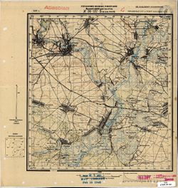
- G7000 s50 .S68 sheet N-36-137-Б
- Caption:
- Не подлежит оглашению
- City:
- М. Нов. Ропск (Novyy Ropsk)
- Copyright Holder:
- No Copyright - United States
- Country:
- СССР (USSR)
- State/Province:
- Украинская ССР (Ukrainian Soviet Socialist Republic), РСФСР (RSFSR), and Западная область (Western oblast)
- Physical Description:
- Scale: 1:50,000
- Persistent URL:
- http://purl.dlib.indiana.edu/iudl/images/VAC9619/VAC9619-001578
- Provenance:
- M. I. Map Library, Atlasblatt
-
- Description:
- 1930
- Subject:
- Geographic Subject: Shumilovka, Topical Subject: Maps, and Topical Subject: Soviet Union
- Publisher:
- Управление военных топографов
- Language:
- Russian
- Identifier:
- VAC9619-001579
- Genre:
- Military Maps and Topographic Maps
- Geographic Location:
- Coordinates: 52, 32, 52.1667, 32.25
- Related URL:
- Download GeoTIFF: https://drive.google.com/open?id=1ag3f8ipdIBTu9si4SD7EBCIPQZrD4_po and Catalog URL: http://iucat.iu.edu/catalog/5020131
- Abstract:
- Modern area represented: Shumilovka, Bryansk oblast, Russia
- Call Number:
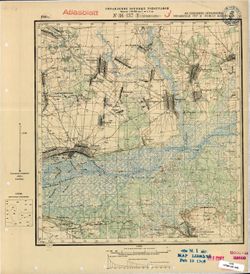
- G7000 s50 .S68 sheet N-36-137-C
- Caption:
- Не подлежит оглашению
- City:
- Шумиловка (Shumilovka)
- Copyright Holder:
- No Copyright - United States
- Country:
- СССР (USSR)
- State/Province:
- Западная область (Western oblast), РСФСР (RSFSR), and Украинская ССР (Ukrainian Soviet Socialist Republic)
- Physical Description:
- Scale: 1:50,000
- Persistent URL:
- http://purl.dlib.indiana.edu/iudl/images/VAC9619/VAC9619-001579
- Provenance:
- M. I. Map Library, Atlasblatt
-
- Description:
- 1929
- Subject:
- Geographic Subject: Zhornokl'ovy, Topical Subject: Maps, and Topical Subject: Soviet Union
- Publisher:
- Управление военных топографов
- Language:
- Russian
- Date Created:
- 1932
- Identifier:
- VAC9619-000991
- Genre:
- Military Maps and Topographic Maps
- Geographic Location:
- Coordinates: 49.833, 31.75, 50, 32
- Related URL:
- Download GeoTIFF: https://drive.google.com/open?id=16Nggj2nwfnBGW6Q4EWeXn7a7Sap0bRb1 and Catalog URL: http://iucat.iu.edu/catalog/5020131
- Abstract:
- Modern area represented: Жорнокльови (Zhornokl'ovy), Cherkasy oblast, Ukraine
- Call Number:
- G7000 s50 .S68 sheet M-36-76-B
- Caption:
- Captured map, Рассекречено, and Не подлежит оглашению (crossed out)
- City:
- Жорноклевы (Zhornoklevy)
- Copyright Holder:
- No Copyright - United States
- Country:
- СССР (USSR)
- State/Province:
- Украинская ССР (Ukrainian Soviet Socialist Republic)
- Physical Description:
- Scale: 1:50,000
- Persistent URL:
- http://purl.dlib.indiana.edu/iudl/images/VAC9619/VAC9619-000991
- Provenance:
- DMA Topographic Center, Army Map Service Library, OMAHA, Library of Congress Geography & Map Division
-
- Description:
- 1929
- Subject:
- Geographic Subject: Hel'myaziv, Topical Subject: Soviet Union, and Topical Subject: Maps
- Publisher:
- Управление военных топографов
- Language:
- Russian
- Identifier:
- VAC9619-000992
- Genre:
- Military Maps and Topographic Maps
- Geographic Location:
- Coordinates: 49.667, 31.75, 49.833, 32
- Related URL:
- Catalog URL: http://iucat.iu.edu/catalog/5020131 and Download GeoTIFF: https://drive.google.com/open?id=10KwpleQWRvznxadNUiRFAxT_ND_u45Xu
- Abstract:
- Modern area represented: Гельмязів (Hel'myaziv), Cherkasy oblast, Ukraine
- Call Number:
- G7000 s50 .S68 sheet M-36-76-D
- Caption:
- Не подлежит оглашению (crossed out), Captured map, and Рассекречено
- City:
- Глемязово (Glemyazovo)
- Copyright Holder:
- No Copyright - United States
- Country:
- СССР (USSR)
- State/Province:
- Украинская ССР (Ukrainian Soviet Socialist Republic)
- Physical Description:
- Scale: 1:50,000
- Persistent URL:
- http://purl.dlib.indiana.edu/iudl/images/VAC9619/VAC9619-000992
- Provenance:
- DMA Topographic Center, Army Map Service Library, OMAHA, Library of Congress Geography & Map Division
-
- Description:
- 1924
- Subject:
- Topical Subject: Soviet Union, Geographic Subject: Trakhtemyriv, and Topical Subject: Maps
- Publisher:
- Управление военных топографов
- Language:
- Russian
- Identifier:
- VAC9619-000989
- Genre:
- Topographic Maps and Military Maps
- Geographic Location:
- Coordinates: 49.833, 31.25, 50, 31.5
- Related URL:
- Catalog URL: http://iucat.iu.edu/catalog/5020131 and Download GeoTIFF: https://drive.google.com/open?id=1zFZnIlQwNet5Y6qGxZ_YDo2x6r4AQQmR
- Abstract:
- Modern area represented: the place was flooded by the Kaniv Reservoir. The nearest populated place: Трахтемирів (Trakhtemyriv), Cherkasy oblast, Ukraine
- Call Number:
- G7000 s50 .S68 sheet M-36-74-C
- Caption:
- Не подлежит оглашению
- City:
- Вьюнище (V"yunishche)
- Copyright Holder:
- No Copyright - United States
- Country:
- СССР (USSR)
- State/Province:
- Украинская ССР (Ukrainian Soviet Socialist Republic)
- Physical Description:
- Scale: 1:50,000
- Persistent URL:
- http://purl.dlib.indiana.edu/iudl/images/VAC9619/VAC9619-000989
- Provenance:
- DMA Topographic Center, Army Map Service Library, OMAHA, Library of Congress Geography & Map Division
-
- Description:
- 1923
- Subject:
- Topical Subject: Maps, Topical Subject: Soviet Union, and Geographic Subject: Ivanivka
- Publisher:
- Управление военных топографов
- Language:
- Russian
- Identifier:
- VAC9619-000983
- Genre:
- Military Maps and Topographic Maps
- Geographic Location:
- Coordinates: 49.833, 30.25, 50, 30.5
- Related URL:
- Catalog URL: http://iucat.iu.edu/catalog/5020131 and Download GeoTIFF: https://drive.google.com/open?id=1svFL_hNRVuzH-uYnPOdr_wG5KaecOuaN
- Abstract:
- Modern area represented: Іванівка (Ivanivka), Kyiv oblast, Ukraine
- Call Number:
- G7000 s50 .S68 sheet M-36-73-B
- Caption:
- Не подлежит оглашению
- City:
- Янкивка (Yankivka)
- Copyright Holder:
- No Copyright - United States
- Country:
- СССР (USSR)
- State/Province:
- Киевская область (Kyiv oblast) and Украинская ССР (Ukrainian Soviet Socialist Republic)
- Physical Description:
- Scale: 1:50,000
- Persistent URL:
- http://purl.dlib.indiana.edu/iudl/images/VAC9619/VAC9619-000983
- Provenance:
- DMA Topographic Center, Army Map Service Library, Library of Congress Geography & Map Division
-
- Description:
- 1923
- Subject:
- Geographic Subject: Rokytne, Topical Subject: Soviet Union, and Topical Subject: Maps
- Publisher:
- Управление военных топографов
- Language:
- Russian
- Date Created:
- 1932
- Identifier:
- VAC9619-000985
- Genre:
- Topographic Maps and Military Maps
- Geographic Location:
- Coordinates: 49.667, 30.25, 49.833, 30.5
- Related URL:
- Download GeoTIFF: https://drive.google.com/open?id=1iaJ6KvA1GY4Z2A2qK0P_HfIVJmnZmYhW and Catalog URL: http://iucat.iu.edu/catalog/5020131
- Abstract:
- Modern area represented: Рокитне (Rokytne), Kyiv oblast, Ukraine
- Call Number:
- G7000 s50 .S68 sheet M-36-73-D
- Caption:
- Не подлежит оглашению
- City:
- Рокитно (Rokitno)
- Copyright Holder:
- No Copyright - United States
- Country:
- СССР (USSR)
- State/Province:
- Украинская ССР (Ukrainian Soviet Socialist Republic) and Киевская область (Kyiv oblast)
- Physical Description:
- Scale: 1:50,000
- Persistent URL:
- http://purl.dlib.indiana.edu/iudl/images/VAC9619/VAC9619-000985
- Provenance:
- DMA Topographic Center, Army Map Service Library, OMAHA, Library of Congress Geography & Map Division
-
- Subject:
- Geographic Subject: Bila Tserkva, Topical Subject: Soviet Union, and Topical Subject: Maps
- Publisher:
- Управление военных топографов
- Language:
- Russian
- Identifier:
- VAC9619-000984
- Genre:
- Military Maps and Topographic Maps
- Geographic Location:
- Coordinates: 49.667, 30, 49.833, 30.25
- Related URL:
- Catalog URL: http://iucat.iu.edu/catalog/5020131 and Download GeoTIFF: https://drive.google.com/open?id=1ftWMaKNlKrCsqA46WkemYc8X5jERvvii
- Abstract:
- Modern area represented: Біла Церква (Bila Tserkva), Kyiv oblast, Ukraine
- Call Number:
- G7000 s50 .S68 sheet M-36-73-C
- Caption:
- Не подлежит оглашению
- City:
- Белая Церковь (Belaya Tserkov’)
- Copyright Holder:
- No Copyright - United States
- Country:
- СССР (USSR)
- State/Province:
- Украинская ССР (Ukrainian Soviet Socialist Republic) and Киевская область (Kyiv oblast)
- Physical Description:
- Scale: 1:50,000
- Persistent URL:
- http://purl.dlib.indiana.edu/iudl/images/VAC9619/VAC9619-000984
- Provenance:
- DMA Topographic Center, Army Map Service Library, OMAHA, Library of Congress Geography & Map Division
-
- Description:
- 1909
- Subject:
- Topical Subject: Maps, Topical Subject: Soviet Union, and Geographic Subject: Hrebinky
- Publisher:
- Управление военных топографов
- Language:
- Russian
- Identifier:
- VAC9619-000982
- Genre:
- Military Maps and Topographic Maps
- Geographic Location:
- Coordinates: 49.833, 30, 50, 30.25
- Related URL:
- Catalog URL: http://iucat.iu.edu/catalog/5020131 and Download GeoTIFF: https://drive.google.com/open?id=1PLrS_xE8qSkoooCJkj85y-lv1KJzTgih
- Abstract:
- Modern area represented: Гребінки (Hrebinky), Kyiv oblast, Ukraine
- Call Number:
- G7000 s50 .S68 sheet M-36-73-A
- Caption:
- Не подлежит оглашению
- City:
- Гребенки (Grebenki)
- Copyright Holder:
- No Copyright - United States
- Country:
- СССР (USSR)
- State/Province:
- Киевская область (Kyiv oblast) and Украинская ССР (Ukrainian Soviet Socialist Republic)
- Physical Description:
- Scale: 1:50,000
- Persistent URL:
- http://purl.dlib.indiana.edu/iudl/images/VAC9619/VAC9619-000982
- Provenance:
- DMA Topographic Center, Army Map Service Library, OMAHA, Library of Congress Geography & Map Division
