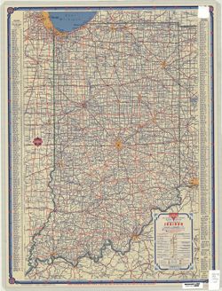
Topical Subject: Roads and Geographic Subject: Indiana
Creator:
H.M. Gousha Company
Publisher:
H.M. Gousha Company
Date Created:
1946
Identifier:
VAC3073-M-00413
Genre:
Road maps
Geographic Location:
Coordinates: W0880500 W0844700 N0414500 N0374600
Related URL:
Catalog URL: https://iucat.iu.edu/catalog/5266639
Abstract:
Includes index to cities and towns. Text and ancillary maps of Chicago and vicinity, Hammond, Gary, Michigan City Region, South Bend, Indiana, Indianapolis...
Geographic Subject: Lawrence County (Ill.), Geographic Subject: Knox County (Ind.), Geographic Subject: Gibson County (Ind.), and Geographic Subject: Wabash ...
Creator:
Geological Survey (U.S.), U.S. Coast and Geodetic Survey, Tweedy, Frank, 1854-1937, Illinois State Geological Survey, Marshall, R. B. (Robert Bradford), 1867...
Publisher:
Geological Survey (U.S.)
Date Created:
1946
Identifier:
VAC3073-M-01410
Genre:
15 minute topographic maps, Quadrangle maps, and Topographic maps
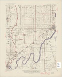
Filing title: Mount Carmel, Ill.-Ind. Edition of 1904, reprinted 1946 with corrections. Polyconic projection. Relief shown by contours and spot heights. Cont...
Call Number:
G4090 s62 .G4 Mount Carmel 1904 rep 1946
Caption:
Imprint: [Washington, D.C.] : U.S. Geological Survey, 1946
Physical Description:
Scale: 1:62,500 and Dimensions: 45 x 42 cm or smaller
Geographic Subject: Warrick County (Ind.), Geographic Subject: Gibson County (Ind.), Geographic Subject: Pike County (Ind.), and Geographic Subject: Vanderbu...
Creator:
Hawkins, Geo. T. (George T.), Blair, H. B. (Herbert Buxton), 1860-1905, Renshawe, John H., and McKinney, R. C. (Robert C.)
Publisher:
Geological Survey (U.S.)
Date Created:
1946
Identifier:
VAC3073-M-01324
Genre:
15 minute topographic maps, Quadrangle maps, and Topographic maps
Engraved Oct. 1902 by U.S.G.S. , Jno. H. Renshawe, geographer in charge , control by Geo. T. Hawkins , topography by R.C. McKinney and H.B. Blair. Edition of...
Call Number:
G4090 s62 .G4 Boonville 1902 rep1946
Caption:
Imprint: [Washington, D.C.] : U.S. Geological Survey, [1946]
Physical Description:
Scale: 1:62,500 and Dimensions: 45 x 42 cm or smaller
Geographic Subject: Danville Region (Ill.), Geographic Subject: Vermillion County (Ind.), and Geographic Subject: Vermilion County (Ill.)
Creator:
Lloyd, W. J. (Topographer), Illinois. Department of Registration and Education, Geological Survey (U.S.), Illinois State Geological Survey, Hawkins, Geo. T. ...
Publisher:
Geological Survey (U.S.)
Date Created:
1946
Identifier:
VAC3073-M-01311
Genre:
15 minute topographic maps, Quadrangle maps, and Topographic maps
Jno. H. Renshawe, geographer in charge , control by U.S. Lake Survey and Geo. T. Hawkins , topography by W. J. Lloyd. Edition of Nov. 1900, reprinted 1946 wi...
R. B. Marshall, chief geographer , W. H. Herron, Geographer in charge , topography by W. H. Griffin and C. L. Sandler , Control by J. R. Ellis and C. H. Semp...
Call Number:
G4090 s62 .G4 Bloomington 1910 R1946
Caption:
Imprint: [Washington, D.C.] : United States, Department of the Interior, Geological Survey, [1946]
Physical Description:
Scale: 1:62,500 and Dimensions: 45 x 42 cm or smaller
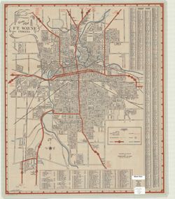
Basically black and white but with parks indicated in blue, city transportation lines in blue, highways in broad red lines, city limits in dashed red lines. ...
Call Number:
G4094.F7 1946 .S5
Caption:
Imprint: Fort Wayne, Indiana: Shockney & Kain. 1946.
Physical Description:
Dimensions: 65 x 55 cm, on sheet 67 x 56 cm and Scale: Scale not given.


![Indiana-Illinois, Vincennes quadrangle : topography [1946 reprint with corrections and without vegetation]](https://iiif.uits.iu.edu/iiif/2/n009x521b%2Ffiles%2Fda21d6eb-ada6-4f1f-8c3c-8022f31eb1a9/full/250,/0/default.jpg)
![Indiana Boonville quadrangle [1946 reprint]](https://iiif.uits.iu.edu/iiif/2/765384187%2Ffiles%2F7c9648cb-7d65-40a1-90c7-0327c2cdfaed/full/250,/0/default.jpg)
![Danville quadrangle, Illinois-Indiana : topographic sheet [1946 reprint]](https://iiif.uits.iu.edu/iiif/2/dz011t65f%2Ffiles%2F0d88511d-4915-434c-875f-219d4a99befe/full/250,/0/default.jpg)
![Indiana Bloomington quadrangle [1946 reprint]](https://iiif.uits.iu.edu/iiif/2/qj72qc04t%2Ffiles%2F069e9c1e-7c2e-4931-8df9-5ba99812cae2/full/250,/0/default.jpg)
![Indiana Bloomington quadrangle [1946 reprint with 21 indexed cave locations]](https://iiif.uits.iu.edu/iiif/2/dz011t645%2Ffiles%2Fbb3033b6-3144-4af2-a6c7-a5710771ff06/full/250,/0/default.jpg)