
Search Constraints
You searched for:
Type
Image
Remove constraint Type: Image
Collections
Indiana Historic Maps
Remove constraint Collections: Indiana Historic Maps
Provenance
An atlas of Indiana / by Robert C. Kingsbury [1970].
Remove constraint Provenance: An atlas of Indiana / by Robert C. Kingsbury [1970].
Search Results
-
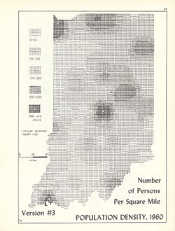
- Subject:
- Geographic Subject: Indiana, Topical Subject: SYMAP (Computer program language), and Topical Subject: Population density
- Creator:
- Indiana University. Research Computing Center, Hollingsworth, John M., and Kingsbury, Robert C.
- Publisher:
- Indiana University. Department of Geography
- Date Created:
- 1970
- Identifier:
- VAC3073-M-00762
- Genre:
- Thematic maps
- Geographic Location:
- Coordinates: W0880700 W0844500 N0414500 N0374600
- Related URL:
- Catalog URL: https://iucat.iu.edu/catalog/15945757
- Abstract:
- Computer generated isopleth map obtained through use of the facilities of Indiana University's Research Computer Center. ASCII-art map created using SYMA...
- Call Number:
- G4091.E2 1960 .K58
- Caption:
- Imprint: Bloomington, Indiana : Department of Geography, Indiana University, [1970]
- Physical Description:
- Dimensions: 26 x 18 cm, on sheet 28 x 21 cm and Scale: Approximately 1:1,950,000
- Alternate Identifier:
- Title Control Number: a15945757 and Alternate ID: 317383IP
- Persistent URL:
- https://purl.dlib.indiana.edu/iudl/images/VAC3073/VAC3073-M-00762
- Provenance:
- An atlas of Indiana / by Robert C. Kingsbury [1970].
-
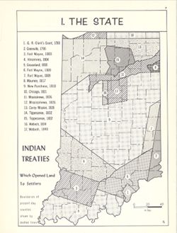
- Subject:
- Geographic Subject: Indiana, Topical Subject: Indians of North America, Topical Subject: Indian land transfers, and Topical Subject: Historical geography
- Creator:
- Hollingsworth, John M. and Kingsbury, Robert C.
- Publisher:
- Indiana University. Department of Geography
- Date Created:
- 1970
- Identifier:
- VAC3073-M-00758
- Genre:
- Thematic maps
- Geographic Location:
- Coordinates: W0880700 W0844500 N0414500 N0374600
- Related URL:
- Catalog URL: https://iucat.iu.edu/catalog/15942649
- Abstract:
- Shows dispossession of Native American communities in Indiana, 1783-1840. Includes index. Detached from: An atlas of Indiana / by Robert C. Kingsbury , wi...
- Call Number:
- G4091.E1 1970 .K56
- Caption:
- Imprint: Bloomington, Indiana : Department of Geography, Indiana University, [1970]
- Physical Description:
- Dimensions: 23 x 18 cm, on sheet 28 x 21 cm and Scale: Approximately 1:1,950,000
- Alternate Identifier:
- Title Control Number: a15942649 and Alternate ID: 317383IP
- Persistent URL:
- https://purl.dlib.indiana.edu/iudl/images/VAC3073/VAC3073-M-00758
- Provenance:
- An atlas of Indiana / by Robert C. Kingsbury [1970].
-
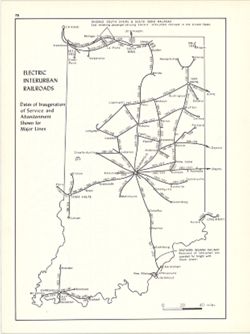
- Subject:
- Geographic Subject: Indiana and Topical Subject: Electric railroads
- Creator:
- Hollingsworth, John M. and Kingsbury, Robert C.
- Publisher:
- Indiana University. Department of Geography
- Date Created:
- 1970
- Identifier:
- VAC3073-M-00731
- Genre:
- Thematic maps
- Geographic Location:
- Coordinates: W0880700 W0844500 N0414500 N0374600
- Related URL:
- Catalog URL: https://iucat.iu.edu/catalog/15937442
- Abstract:
- Shows dates of inauguration of service and abandonment shown for major lines. Detached from: An atlas of Indiana / by Robert C. Kingsbury , with contribut...
- Call Number:
- G4091.P3 1970 .K57
- Caption:
- Imprint: Bloomington, Indiana : Department of Geography, Indiana University, [1970]
- Physical Description:
- Scale: Approximately 1:1,950,000 and Dimensions: 26 x 18 cm, on sheet 28 x 21 cm
- Alternate Identifier:
- Alternate ID: 317383IP and Title Control Number: a15937442
- Persistent URL:
- https://purl.dlib.indiana.edu/iudl/images/VAC3073/VAC3073-M-00731
- Provenance:
- An atlas of Indiana / by Robert C. Kingsbury [1970].
-
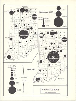
- Subject:
- Topical Subject: Wholesale trade, Topical Subject: Labor supply, and Geographic Subject: Indiana
- Creator:
- Hollingsworth, John M. and Kingsbury, Robert C.
- Publisher:
- Indiana University. Department of Geography
- Date Created:
- 1970
- Identifier:
- VAC3073-M-00715
- Genre:
- Thematic maps
- Geographic Location:
- Coordinates: W0880700 W0844500 N0414500 N0374600
- Related URL:
- Catalog URL: https://iucat.iu.edu/catalog/15987137
- Abstract:
- 2 maps on 1 sheet, Wholesale trade, employees, 1967, and Wholesale trade sales, 1963. Graduated symbol maps. Detached from: An atlas of Indiana / by Rober...
- Call Number:
- G4091.G8 1963 .K58
- Caption:
- Imprint: Bloomington, Indiana : Department of Geography, Indiana University, [1970]
- Physical Description:
- Dimensions: on sheet 28 x 21 cm and Scale: Approximately 1:2,700,000
- Alternate Identifier:
- Title Control Number: a15987137 and Alternate ID: 317383IP
- Persistent URL:
- https://purl.dlib.indiana.edu/iudl/images/VAC3073/VAC3073-M-00715
- Provenance:
- An atlas of Indiana / by Robert C. Kingsbury [1970].
-
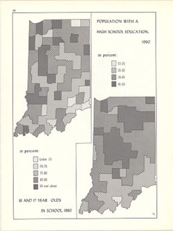
- Subject:
- Topical Subject: High school attendance, Topical Subject: High school graduates, and Geographic Subject: Indiana
- Creator:
- Hollingsworth, John M. and Kingsbury, Robert C.
- Publisher:
- Indiana University. Department of Geography
- Date Created:
- 1970
- Identifier:
- VAC3073-M-00713
- Genre:
- Thematic maps
- Geographic Location:
- Coordinates: W0880700 W0844500 N0414500 N0374600
- Related URL:
- Catalog URL: https://iucat.iu.edu/catalog/15942453
- Abstract:
- 2 maps on 1 sheet (Population with a high school education, 1960, 16 and 17 years in school, 1960). Choropleth maps. Detached from: An atlas of Indiana / ...
- Call Number:
- G4091.E68 1960 .K56
- Caption:
- Imprint: Department of Geography, Indiana University
- Physical Description:
- Scale: Approximately 1:3,000,000 and Dimensions: each 26 x 10 cm, on sheet 28 x 21 cm
- Alternate Identifier:
- Alternate ID: 317383IP and Title Control Number: a15942453
- Persistent URL:
- https://purl.dlib.indiana.edu/iudl/images/VAC3073/VAC3073-M-00713
- Provenance:
- An atlas of Indiana / by Robert C. Kingsbury [1970].
-
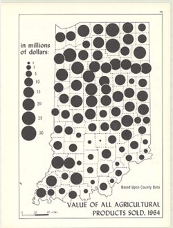
- Subject:
- Geographic Subject: Indiana, Topical Subject: Produce trade, and Topical Subject: Farm produce
- Creator:
- Hollingsworth, John M. and Kingsbury, Robert C.
- Publisher:
- Indiana University. Department of Geography
- Date Created:
- 1970
- Identifier:
- VAC3073-M-00685
- Genre:
- Thematic maps
- Geographic Location:
- Coordinates: W0880700 W0844500 N0414500 N0374600
- Related URL:
- Catalog URL: https://iucat.iu.edu/catalog/15986955
- Abstract:
- Graduated symbol map. Based upon county data, in millions of dollars. Detached from: An atlas of Indiana / by Robert C. Kingsbury , with contributions fro...
- Call Number:
- G4091.J6 1964 .K55
- Caption:
- Imprint: Bloomington, Indiana : Department of Geography, Indiana University, [1970]
- Physical Description:
- Dimensions: 26 x 18 cm, on sheet 28 x 21 cm and Scale: Approximately 1:1,950,000
- Alternate Identifier:
- Title Control Number: a15986955 and Alternate ID: 317383IP
- Persistent URL:
- https://purl.dlib.indiana.edu/iudl/images/VAC3073/VAC3073-M-00685
- Provenance:
- An atlas of Indiana / by Robert C. Kingsbury [1970].
-
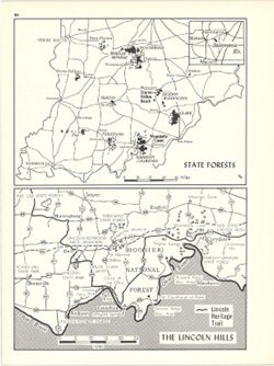
- Subject:
- Topical Subject: Forest reserves, Geographic Subject: Indiana, Geographic Subject: Lincoln Hills Resource Conservation and Development Project Area (Ind.), a...
- Creator:
- Hollingsworth, John M. and Kingsbury, Robert C.
- Publisher:
- Indiana University. Department of Geography
- Date Created:
- 1970
- Identifier:
- VAC3073-M-00668
- Genre:
- Tourist maps and Thematic maps
- Geographic Location:
- Coordinates: W0880610 W0844655 N0393200 N0374600
- Related URL:
- Catalog URL: https://iucat.iu.edu/catalog/15938315
- Abstract:
- 2 maps on 1 sheet, State Forests and The Lincoln Hills. Lincoln Hills map (1:690,000) shows Lincoln Heritage Trail, various Lincoln-related sites and other n...
- Call Number:
- G4091.K2 1970 .K56
- Caption:
- Imprint: Bloomington, Indiana : Department of Geography, Indiana University, [1970]
- Physical Description:
- Scale: Approximately 1:1,600,000 and Dimensions: each 13 x 18 cm, on sheet 28 x 21 cm
- Alternate Identifier:
- Alternate ID: 317383IP and Title Control Number: a15938315
- Persistent URL:
- https://purl.dlib.indiana.edu/iudl/images/VAC3073/VAC3073-M-00668
- Provenance:
- An atlas of Indiana / by Robert C. Kingsbury [1970].
-
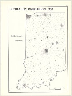
- Subject:
- Topical Subject: Population geography, Geographic Subject: Indiana, and Topical Subject: Population
- Creator:
- Kingsbury, Robert C. and Hollingsworth, John M.
- Publisher:
- Indiana University. Department of Geography
- Date Created:
- 1970
- Identifier:
- VAC3073-M-00662
- Genre:
- Thematic maps
- Geographic Location:
- Coordinates: W0880700 W0844500 N0414500 N0374600
- Related URL:
- Catalog URL: https://iucat.iu.edu/catalog/15942930
- Abstract:
- Dot distribution map. Detached from: An atlas of Indiana / by Robert C. Kingsbury , with contributions from John M. Hollingsworth and others. Bloomington,...
- Call Number:
- G4091.E2 1960 .K56
- Caption:
- Imprint: Bloomington, Indiana : Department of Geography, Indiana University, [1970]
- Physical Description:
- Dimensions: 26 x 18 cm, on sheet 28 x 21 cm and Scale: Approximately 1:1,950,000
- Alternate Identifier:
- Title Control Number: a15942930 and Alternate ID: 317383IP
- Persistent URL:
- https://purl.dlib.indiana.edu/iudl/images/VAC3073/VAC3073-M-00662
- Provenance:
- An atlas of Indiana / by Robert C. Kingsbury [1970].
-
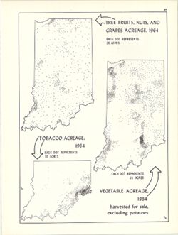
- Subject:
- Geographic Subject: Indiana, Topical Subject: Tobacco--Geographical distribution, Topical Subject: Fruit--Geographical distribution, and Topical Subject: Veg...
- Creator:
- Kingsbury, Robert C. and Hollingsworth, John M.
- Publisher:
- Indiana University. Department of Geography
- Date Created:
- 1970
- Identifier:
- VAC3073-M-00658
- Genre:
- Thematic maps
- Geographic Location:
- Coordinates: W0880700 W0844500 N0414500 N0374600
- Related URL:
- Catalog URL: https://iucat.iu.edu/catalog/15987083
- Abstract:
- 3 maps on 1 sheet, Vegetable acreage, 1964, Tree fruits, nuts, and grapes acreage, 1964, and Tobacco acreage, 1964. Dot distribution maps. Detached from:...
- Call Number:
- G4091.J6 1964 .K55
- Caption:
- Imprint: Bloomington, Indiana : Department of Geography, Indiana University, [1970]
- Physical Description:
- Scale: Approximately 1:2,700,000 and Dimensions: on sheet 28 x 21 cm
- Alternate Identifier:
- Alternate ID: 317383IP and Title Control Number: a15987083
- Persistent URL:
- https://purl.dlib.indiana.edu/iudl/images/VAC3073/VAC3073-M-00658
- Provenance:
- An atlas of Indiana / by Robert C. Kingsbury [1970].
-
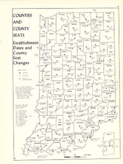
- Subject:
- Topical Subject: Counties, Topical Subject: Cities and towns, Geographic Subject: Indiana, and Topical Subject: Administrative and political divisions
- Creator:
- Hollingsworth, John M. and Kingsbury, Robert C.
- Publisher:
- Indiana University. Department of Geography
- Date Created:
- 1970
- Identifier:
- VAC3073-M-00655
- Genre:
- Thematic maps
- Geographic Location:
- Coordinates: W0880700 W0844500 N0414500 N0374600
- Related URL:
- Catalog URL: https://iucat.iu.edu/catalog/15942435
- Abstract:
- Shows county seat establishment dates and county seat changes. Includes map insert of Martin County, Indiana. Detached from: An atlas of Indiana / by Robe...
- Call Number:
- G4091.F7 1970 .K57
- Caption:
- Imprint: Bloomington, Indiana : Department of Geography, Indiana University, [1970]
- Physical Description:
- Dimensions: 26 x 18 cm, on sheet 28 x 21 cm and Scale: Approximately 1:1,800,000
- Alternate Identifier:
- Alternate ID: 317383IP and Title Control Number: a15942435
- Persistent URL:
- https://purl.dlib.indiana.edu/iudl/images/VAC3073/VAC3073-M-00655
- Provenance:
- An atlas of Indiana / by Robert C. Kingsbury [1970].
