
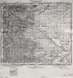
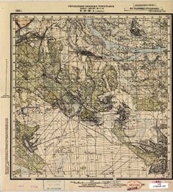
Search Constraints
You searched for:
Publisher
Управление военных топографов
Remove constraint Publisher: Управление военных топографов
« Previous |
1 - 50 of 465
|
Next »
Search Results
-
- Subject:
- Topical Subject: Soviet Union, Topical Subject: Maps, and Geographic Subject: Zabiele Wielkie
- Publisher:
- Управление военных топографов
- Language:
- Russian
- Date Created:
- 1941
- Identifier:
- VAC9619-000377
- Genre:
- Military Maps and Topographic Maps
- Geographic Location:
- Coordinates: 53, 21.25, 53.1667, 21.5
- Related URL:
- Download GeoTIFF: https://drive.google.com/open?id=1vBJpy_OOZhPZY7uC8H15kx7WerCnXEjq and Catalog URL: http://iucat.iu.edu/catalog/5020131
- Abstract:
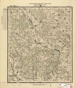
- Modern area represented: Zabiele Wielkie, Poland
- Call Number:
- G7000 s50 .S68 sheet N-34-103-D
- Caption:
- Captured map
- City:
- Забеле Вельке (Zabiele Wielkie)
- Copyright Holder:
- No Copyright - United States
- State/Province:
- Область государственных интересов Германии (Region of German state interests)
- Physical Description:
- Scale: 1:50,000
- Persistent URL:
- http://purl.dlib.indiana.edu/iudl/images/VAC9619/VAC9619-000377
- Provenance:
- DMA Topographic Center, Army Map Service Library, OMAHA
-
- Description:
- 1894
- Subject:
- Topical Subject: Soviet Union, Topical Subject: Maps, and Geographic Subject: Vaivara Parish
- Publisher:
- Управление военных топографов
- Language:
- Russian
- Date Created:
- 1939
- Identifier:
- VAC9619-001807
- Genre:
- Military Maps and Topographic Maps
- Geographic Location:
- Coordinates: 59.333, 27.75, 59.5, 28
- Related URL:
- Catalog URL: http://iucat.iu.edu/catalog/5020131 and Download GeoTIFF: https://drive.google.com/open?id=1xZRkvws2fTzTf7QBQ5p6dQ2m53SU1f7c
- Abstract:
- Modern area represented: Vaivara Parish, Ida-Viru county, Estonia
- Call Number:
- G7000 s50 .S68 sheet O-35-20-D
- City:
- Вайвара (Vaivara)
- Copyright Holder:
- No Copyright - United States
- Country:
- Эстония (Estonia)
- Physical Description:
- Scale: 1:50,000
- Persistent URL:
- http://purl.dlib.indiana.edu/iudl/images/VAC9619/VAC9619-001807
- Provenance:
- DMA Topographic Center, Army Map Service Library, OMAHA, Library of Congress Geography & Map Division
-
- Subject:
- Geographic Subject: Mlyniv, Topical Subject: Soviet Union, and Topical Subject: Maps
- Publisher:
- Управление военных топографов
- Language:
- Russian
- Date Created:
- 1937
- Identifier:
- VAC9619-000218
- Genre:
- Military Maps and Topographic Maps
- Geographic Location:
- Coordinates: 50.5, 25.5, 50.667, 25.75
- Related URL:
- Download GeoTIFF: https://drive.google.com/open?id=13uyKeOnyHt_42-Dl3iUUZgFJz7RZ1yEB and Catalog URL: http://iucat.iu.edu/catalog/5020131
- Abstract:
- Modern area represented: Mlyniv, Ukraine
- Call Number:
- G7000 s50 .S68 sheet M-35-52-A
- City:
- Млынув (Mlynuv)
- Copyright Holder:
- No Copyright - United States
- Country:
- Польша (Poland)
- Physical Description:
- Scale: 1:50,000
- Persistent URL:
- http://purl.dlib.indiana.edu/iudl/images/VAC9619/VAC9619-000218
- Provenance:
- DMA Topographic Center, Army Map Service Library, OMAHA, Library of Congress Geography & Map Division
-
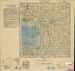
- Description:
- 1932
- Subject:
- Topical Subject: Soviet Union, Topical Subject: Maps, and Geographic Subject: Parevichi
- Publisher:
- Управление военных топографов
- Language:
- Russian
- Date Created:
- 1935
- Identifier:
- VAC9619-003528
- Genre:
- Topographic Maps and Military Maps
- Geographic Location:
- Coordinates: 57.3333, 30.25, 57.5, 30.5
- Related URL:
- Download GeoTIFF: https://drive.google.com/file/d/1XoJ_B73bclp0wAy4LtwTrHbzPBWOIEMp/view?usp=sharing and Catalog URL: http://iucat.iu.edu/catalog/5020131
- Abstract:
- Modern area represented: Паревичи (Parevichi), Pskovskaya oblast, Russia
- Call Number:
- GM G7000 s50 .S68 sheet O-36-85-D
- Caption:
- Не подлежит оглашению
- City:
- Паревичи (Parevichi)
- Copyright Holder:
- No Copyright - United States
- Country:
- СССР (USSR)
- State/Province:
- Ленинградская область (Leningrad oblast) and РСФСР (RSFSR)
- Physical Description:
- Scale: 1:50,000
- Persistent URL:
- http://purl.dlib.indiana.edu/iudl/images/VAC9619/VAC9619-003528
- Provenance:
- Army Map Service Library, OMAHA, Library of Congress Geography & Map Division
-
- Description:
- 1932
- Subject:
- Topical Subject: Soviet Union, Topical Subject: Maps, and Geographic Subject: Solov'yevo
- Publisher:
- Управление военных топографов
- Language:
- Russian
- Date Created:
- 1935
- Identifier:
- VAC9619-002914
- Genre:
- Topographic Maps and Military Maps
- Geographic Location:
- Coordinates: 57.667, 30.5, 57.833, 30.75
- Related URL:
- Catalog URL: http://iucat.iu.edu/catalog/5020131 and Download GeoTIFF: https://drive.google.com/file/d/1CLxRUBJnLOwI8Yau6rAVhpzupqZ-nCi6/view?usp=sharing
- Abstract:
- Modern area represented: Соловьево (Solov'yevo), Novgorodskaya oblast, Russia
- Call Number:
- GM G7000 s50 .S68 sheet O-36-74-С
- Caption:
- Не подлежит оглашению
- City:
- Соловьево (Solov'yevo)
- Copyright Holder:
- No Copyright - United States
- Country:
- СССР (USSR)
- State/Province:
- РСФСР (RSFSR) and Ленинградская область (Leningrad oblast)
- Physical Description:
- Scale: 1:50,000
- Persistent URL:
- http://purl.dlib.indiana.edu/iudl/images/VAC9619/VAC9619-002914
- Provenance:
- DMA Topographic Center, Army Map Service Library, OMAHA, Library of Congress Geography & Map Division
-
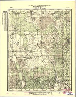
- Description:
- 1932
- Subject:
- Topical Subject: Maps, Topical Subject: Soviet Union, and Geographic Subject: Belebelka
- Publisher:
- Управление военных топографов
- Language:
- Russian
- Date Created:
- 1935
- Identifier:
- VAC9619-003529
- Genre:
- Military Maps and Topographic Maps
- Geographic Location:
- Coordinates: 57.5, 30.75, 57.6667, 31.0
- Related URL:
- Download GeoTIFF: https://drive.google.com/file/d/1MsF7NM8_S3piH2IIQADcekLjZ5KjdXss/view?usp=sharing and Catalog URL: http://iucat.iu.edu/catalog/5020131
- Abstract:
- Modern area represented: Белебелка (Belebelka), Novgorodskaya oblast, Russia
- Call Number:
- GM G7000 s50 .S68 sheet O-36-86-B
- Caption:
- Captured map and Не подлежит оглашению
- City:
- Белебелка (Belebelka)
- Copyright Holder:
- No Copyright - United States
- Country:
- СССР (USSR)
- State/Province:
- РСФСР (RSFSR) and Ленинградская область (Leningrad oblast)
- Physical Description:
- Scale: 1:50,000
- Persistent URL:
- http://purl.dlib.indiana.edu/iudl/images/VAC9619/VAC9619-003529
- Provenance:
- DMA Topographic Center, Army Map Service Library, OMAHA, Library of Congress Geography & Map Division
-
- Description:
- 1932
- Subject:
- Topical Subject: Soviet Union, Topical Subject: Maps, and Geographic Subject: Zapol'ye
- Publisher:
- Управление военных топографов
- Language:
- Russian
- Date Created:
- 1935
- Identifier:
- VAC9619-003530
- Genre:
- Topographic Maps and Military Maps
- Geographic Location:
- Coordinates: 57.3333, 30.5, 57.5, 30.75
- Related URL:
- Download GeoTIFF: https://drive.google.com/file/d/1abqgMUIx4YwMEuwFrohfNLhOCdIr0eph/view?usp=sharing and Catalog URL: http://iucat.iu.edu/catalog/5020131
- Abstract:
- Modern area represented: Заполье (Zapol'ye), Novgorodskaya oblast, Russia
- Call Number:
- GM G7000 s50 .S68 sheet O-36-86-C
- Caption:
- Для служебного пользования and Captured map
- City:
- Заполье (Zapol'ye)
- Copyright Holder:
- No Copyright - United States
- Country:
- СССР (USSR)
- State/Province:
- РСФСР (RSFSR) and Ленинградская область (Leningrad oblast)
- Physical Description:
- Scale: 1:50,000
- Persistent URL:
- http://purl.dlib.indiana.edu/iudl/images/VAC9619/VAC9619-003530
- Provenance:
- DMA Topographic Center, Army Map Service Library, OMAHA, Library of Congress Geography & Map Division
-
- Description:
- 1928
- Subject:
- Geographic Subject: Monastyryshche, Topical Subject: Soviet Union, and Topical Subject: Maps
- Publisher:
- Управление военных топографов
- Language:
- Russian
- Date Created:
- 1934
- Identifier:
- VAC9619-000950
- Genre:
- Topographic Maps and Military Maps
- Geographic Location:
- Coordinates: 50.66667, 32.0, 50.83333, 32.25
- Related URL:
- Download GeoTIFF: https://drive.google.com/open?id=1osXpm-MYY-r77zS8l33PrM8YxdBG8aOy and Catalog URL: http://iucat.iu.edu/catalog/5020131
- Abstract:
- Modern area represented: Monastyryshche, Chernihiv oblast, Ukraine
- Call Number:
- G7000 s50 .S68 sheet M-36-41-B
- Caption:
- Не подлежит оглашению
- City:
- Монастырище (Monastyrishche)
- Copyright Holder:
- No Copyright - United States
- Country:
- СССР (USSR)
- State/Province:
- Украинская ССР (Ukrainian Soviet Socialist Republic)
- Physical Description:
- Scale: 1:50,000
- Persistent URL:
- http://purl.dlib.indiana.edu/iudl/images/VAC9619/VAC9619-000950
- Provenance:
- DMA Topographic Center, Army Map Service Library, OMAHA, Library of Congress Geography & Map Division
-
- Description:
- 1928
- Subject:
- Geographic Subject: Novyi Bykiv, Topical Subject: Maps, and Topical Subject: Soviet Union
- Publisher:
- Управление военных топографов
- Language:
- Russian
- Date Created:
- 1934
- Identifier:
- VAC9619-000966
- Genre:
- Topographic Maps and Military Maps
- Geographic Location:
- Coordinates: 50.5, 31.5, 50.666667, 31.75
- Related URL:
- Catalog URL: http://iucat.iu.edu/catalog/5020131 and Download GeoTIFF: https://drive.google.com/open?id=1YPJFz3bATg4BjHxCqaVB8yzXJW7FfSqu
- Abstract:
- Modern area represented: Novyi Bykiv, Chernihiv oblast, Ukraine
- Call Number:
- G7000 s50 .S68 sheet M-36-52-A
- Caption:
- Не подлежит оглашению
- City:
- Новый Быков (Novyi Bykov)
- Copyright Holder:
- No Copyright - United States
- Country:
- СССР (USSR)
- State/Province:
- Украинская ССР (Ukrainian Soviet Socialist Republic)
- Physical Description:
- Scale: 1:50,000
- Persistent URL:
- http://purl.dlib.indiana.edu/iudl/images/VAC9619/VAC9619-000966
- Provenance:
- DMA Topographic Center, Army Map Service Library, Library of Congress Geography & Map Division
-
- Description:
- 1926
- Subject:
- Geographic Subject: Rechytsa, Topical Subject: Soviet Union, and Topical Subject: Maps
- Publisher:
- Управление военных топографов
- Language:
- Russian
- Date Created:
- 1934
- Identifier:
- VAC9619-001551
- Genre:
- Topographic Maps and Military Maps
- Geographic Location:
- Coordinates: 52.3333, 30.25, 52.5, 30.5
- Related URL:
- Catalog URL: http://iucat.iu.edu/catalog/5020131 and Download GeoTIFF: https://drive.google.com/open?id=1W3PoDvQej2qE34tAwwmuO7ZWbCQ38cNU
- Abstract:
- Modern area represented: Rechytsa, Homyel oblast, Belarus
- Call Number:
- G7000 s50 .S68 sheet N-36-121-D
- Caption:
- Не подлежит оглашению
- City:
- Речица (Rechytsa)
- Copyright Holder:
- No Copyright - United States
- Country:
- СССР (USSR)
- State/Province:
- Белорусская ССР (Byelorussian Soviet Socialist Republic)
- Physical Description:
- Scale: 1:50,000
- Persistent URL:
- http://purl.dlib.indiana.edu/iudl/images/VAC9619/VAC9619-001551
- Provenance:
- CIA Map Branch -- Received
-
- Description:
- 1929
- Subject:
- Geographic Subject: Bronnoye, Topical Subject: Soviet Union, and Topical Subject: Maps
- Publisher:
- Управление военных топографов
- Language:
- Russian
- Date Created:
- 1934
- Identifier:
- VAC9619-001563
- Genre:
- Topographic Maps and Military Maps
- Geographic Location:
- Coordinates: 52.1667, 30.25, 52.3333, 30.5
- Related URL:
- Download GeoTIFF: https://drive.google.com/open?id=11UlRUXshSkRws4kkl47mEECybC9419Dv and Catalog URL: http://iucat.iu.edu/catalog/5020131
- Abstract:
- Modern area represented: Bronnoye, Homyel Voblasc, Belarus
- Call Number:
- G7000 s50 .S68 sheet N-36-133-Б
- Caption:
- Не подлежит оглашению
- City:
- Бронное (Bronnoye)
- Copyright Holder:
- No Copyright - United States
- Country:
- СССР (USSR)
- State/Province:
- Белорусская ССР (Byelorussian Soviet Socialist Republic)
- Physical Description:
- Scale: 1:50,000
- Persistent URL:
- http://purl.dlib.indiana.edu/iudl/images/VAC9619/VAC9619-001563
- Provenance:
- M. I. Map Library, GS, RA
-
- Description:
- 1929
- Subject:
- Geographic Subject: Ковпита (Kovpyta), Topical Subject: Maps, and Topical Subject: Soviet Union
- Publisher:
- Управление военных топографов
- Language:
- Russian
- Date Created:
- 1934
- Identifier:
- VAC9619-000922
- Genre:
- Topographic Maps and Military Maps
- Geographic Location:
- Coordinates: 51.3333, 30.75, 51.5, 31
- Related URL:
- Download GeoTIFF: https://drive.google.com/open?id=1wwFBx8Ytl_OyaIeA8BqneJwwGcqknvXo and Catalog URL: http://iucat.iu.edu/catalog/5020131
- Abstract:
- Modern area represented: Ковпита (Kovpyta), Chernihiv Oblast, Ukraine
- Call Number:
- G7000 s50 .S68 sheet M-36-14-D
- Caption:
- Не подлежит оглашению
- City:
- Колпыта (Kolpyta)
- Copyright Holder:
- No Copyright - United States
- Country:
- СССР (USSR)
- State/Province:
- Украинская ССР (Ukrainian Soviet Socialist Republic)
- Physical Description:
- Scale: 1:50,000
- Persistent URL:
- http://purl.dlib.indiana.edu/iudl/images/VAC9619/VAC9619-000922
- Provenance:
- M. I. Map Library
-
- Description:
- 1921
- Subject:
- Topical Subject: Soviet Union, Topical Subject: Maps, and Geographic Subject: Великі Копані (Velyki Kopani)
- Publisher:
- Управление военных топографов
- Language:
- Russian
- Date Created:
- 1933
- Identifier:
- VAC9619-000122
- Genre:
- Military Maps and Topographic Maps
- Geographic Location:
- Coordinates: 46.3333, 32.75, 46.5, 33
- Related URL:
- https://drive.google.com/open?id=1YVaxNwv9dRB21t0pKObSeHn__dPVCw7l, Download GeoTIFF: https://drive.google.com/open?id=1PpCBrQtUKhwRBcPpZgQf3aNkYSHRD9F5, and...
- Abstract:
- Modern area represented: Velyki Kopani, Kherson oblast, Ukraine
- Call Number:
- G7000 s50 .S68 sheet L-36-54-D
- Caption:
- Не подлежит оглашению,Секретно
- City:
- Большие Копани (Bolshiye Kopani)
- Copyright Holder:
- No Copyright - United States
- Country:
- СССР (USSR)
- State/Province:
- Украинская ССР (Ukrainian Soviet Socialist Republic)
- Physical Description:
- Scale: 1:50,000
- Persistent URL:
- http://purl.dlib.indiana.edu/iudl/images/VAC9619/VAC9619-000122
- Provenance:
- DMA Topographic Center, Army Map Service Library, OMAHA
-
- Description:
- 1926
- Subject:
- Topical Subject: Soviet Union, Topical Subject: Maps, and Geographic Subject: Zhizhitsa
- Publisher:
- Управление военных топографов
- Language:
- Russian
- Date Created:
- 1933
- Identifier:
- VAC9619-003490
- Genre:
- Topographic Maps and Military Maps
- Geographic Location:
- Coordinates: 56.167, 31.25, 56.333, 31.5
- Related URL:
- Download GeoTIFF: https://drive.google.com/file/d/1akHjhCoHjwS7M9NoqxD_Wge8T9N5pm0n/view?usp=sharing and Catalog URL: http://iucat.iu.edu/catalog/5020131
- Abstract:
- Modern area represented: Жижица (Zhizhitsa), Pskovskaya oblast, Russia
- Call Number:
- G7000 s50 .S68 sheet O-36-135-B
- Caption:
- Captured map and Не подлежит оглашению
- City:
- Жижица (Zhizhitsa)
- Copyright Holder:
- No Copyright - United States
- Country:
- СССР (USSR)
- State/Province:
- Западная область (Western oblast) and РСФСР (RSFSR)
- Physical Description:
- Scale: 1:50,000
- Persistent URL:
- http://purl.dlib.indiana.edu/iudl/images/VAC9619/VAC9619-003490
- Provenance:
- DMA Topographic Center, Army Map Service Library, OMAHA, Library of Congress Geography & Map Division
-
- Description:
- 1926
- Subject:
- Geographic Subject: Vysokoye, Topical Subject: Maps, and Topical Subject: Soviet Union
- Publisher:
- Управление военных топографов
- Language:
- Russian
- Date Created:
- 1933
- Identifier:
- VAC9619-003462
- Genre:
- Topographic Maps and Military Maps
- Geographic Location:
- Coordinates: 56.333, 31.25, 56.5, 31.5
- Related URL:
- Download GeoTIFF: https://drive.google.com/file/d/1tidCd1WzQh7iMs7Mrr31FLldj-CyVjKl/view?usp=sharing and Catalog URL: http://iucat.iu.edu/catalog/5020131
- Abstract:
- Modern area represented: Высокое (Vysokoye), Tverskaya oblast, Russia
- Call Number:
- GM G7000 s50 .S68 sheet O-36-123-D
- Caption:
- Не подлежит оглашению
- City:
- Лошаеды (Loshayedy)
- Copyright Holder:
- No Copyright - United States
- Country:
- СССР (USSR)
- State/Province:
- Западная область (Western oblast) and РСФСР (RSFSR)
- Physical Description:
- Scale: 1:50,000
- Persistent URL:
- http://purl.dlib.indiana.edu/iudl/images/VAC9619/VAC9619-003462
- Provenance:
- M. I. Map Library, Library of Congress Geography & Map Division
-
- Subject:
- Geographic Subject: Sheykino, Topical Subject: Soviet Union, and Topical Subject: Maps
- Publisher:
- Управление военных топографов
- Language:
- Russian
- Date Created:
- 1933
- Identifier:
- VAC9619-003461
- Genre:
- Topographic Maps and Military Maps
- Geographic Location:
- Coordinates: 56.333, 31, 56.5, 31.25
- Related URL:
- Catalog URL: http://iucat.iu.edu/catalog/5020131 and Download GeoTIFF: https://drive.google.com/file/d/1fjd216-PEi63ervxn65sPkj51GMPE7fJ/view?usp=sharing
- Abstract:
- Modern area represented: Шейкино (Sheykino), Pskovskaya oblast, Russia
- Call Number:
- GM G7000 s50 .S68 sheet O-36-123-C
- Caption:
- Не подлежит оглашению
- City:
- Шейкино (Sheykino)
- Copyright Holder:
- No Copyright - United States
- Country:
- СССР (USSR)
- State/Province:
- РСФСР (RSFSR) and Западная область (Western oblast)
- Physical Description:
- Scale: 1:50,000
- Persistent URL:
- http://purl.dlib.indiana.edu/iudl/images/VAC9619/VAC9619-003461
- Provenance:
- M. I. Map Library, Justus Perthes Kartensammlung
-
- Description:
- 1871
- Subject:
- Topical Subject: Soviet Union and Topical Subject: Maps
- Publisher:
- Управление военных топографов
- Language:
- Russian
- Date Created:
- 1933
- Identifier:
- VAC9619-000085
- Genre:
- Military Maps and Topographic Maps
- Geographic Location:
- Coordinates: 39, 46.5, 39.1667, 46.75
- Related URL:
- Catalog URL: http://iucat.iu.edu/catalog/5020131 and Download GeoTIFF: https://drive.google.com/open?id=11Y-tiJbYa2ukpMly-Z1AM7SovrCQDBd5
- Call Number:
- G7000 s50 .S68 sheet J-38-34-C
- Caption:
- Не подлежит оглашению,Временное издание
- City:
- Мирдживан (Mirdzhivan)
- Copyright Holder:
- No Copyright - United States
- Country:
- СССР (USSR) and Персия (Persia)
- State/Province:
- Армянская ССР (Armenian Soviet Socialist Republic) and Азербайджанская ССР (Azerbaijan Soviet Socialist Republic)
- Physical Description:
- Scale: 1:50,000
- Persistent URL:
- http://purl.dlib.indiana.edu/iudl/images/VAC9619/VAC9619-000085
-
- Description:
- 1930
- Subject:
- Geographic Subject: Kachkarivka, Topical Subject: Soviet Union, and Topical Subject: Maps
- Publisher:
- Управление военных топографов
- Language:
- Russian
- Date Created:
- 1933
- Identifier:
- VAC9619-000109
- Genre:
- Military Maps and Topographic Maps
- Geographic Location:
- Coordinates: 47, 33.5, 47.1667, 33.75
- Related URL:
- https://drive.google.com/open?id=1W43g9MiU8xvPdVcAWPMDiWnj5AHoRdgg, Catalog URL: http://iucat.iu.edu/catalog/5020131, and Download GeoTIFF: https://drive.goo...
- Abstract:
- Modern area represented: Kachkarivka, Kherson oblast, Ukraine
- Call Number:
- G7000 s50 .S68 sheet L-36-32-C
- Caption:
- Не подлежит оглашению
- City:
- Качкаровка (Kachkarovka)
- Copyright Holder:
- No Copyright - United States
- Country:
- СССР (USSR)
- State/Province:
- Украинская ССР (Ukrainian Soviet Socialist Republic)
- Physical Description:
- Scale: 1:50,000
- Persistent URL:
- http://purl.dlib.indiana.edu/iudl/images/VAC9619/VAC9619-000109
- Provenance:
- DMA Topographic Center, Army Map Service Library, Library of Congress Geography & Map Division
-
- Subject:
- Geographic Subject: Rozhiv, Topical Subject: Maps, and Topical Subject: Soviet Union
- Publisher:
- Управление военных топографов
- Language:
- Russian
- Date Created:
- 1933
- Identifier:
- VAC9619-000231
- Genre:
- Military Maps and Topographic Maps
- Geographic Location:
- Coordinates: 50.333, 29.5, 50.5, 29.75
- Related URL:
- Download GeoTIFF: https://drive.google.com/open?id=1GI_3iVbmAy00COqMBiZDf0p7TKUCV6sH and Catalog URL: http://iucat.iu.edu/catalog/5020131
- Abstract:
- Modern area represented: Рожів (Rozhiv), Kyiv oblast, Ukraine
- Call Number:
- G7000 s50 .S68 sheet M-35-60-C
- Caption:
- Не подлежит оглашению and Captured map
- City:
- Рожев (Rozhev)
- Copyright Holder:
- No Copyright - United States
- Country:
- СССР (USSR)
- State/Province:
- Украинская ССР (Ukrainian Soviet Socialist Republic) and Киевская область (Kyiv oblast)
- Physical Description:
- Scale: 1:50,000
- Persistent URL:
- http://purl.dlib.indiana.edu/iudl/images/VAC9619/VAC9619-000231
- Provenance:
- DMA Topographic Center, Army Map Service Library, Library of Congress Geography & Map Division
-
- Description:
- 1931
- Subject:
- Geographic Subject: Prigarovka, Topical Subject: Soviet Union, and Topical Subject: Maps
- Publisher:
- Управление военных топографов
- Language:
- Russian
- Date Created:
- 1932
- Identifier:
- VAC9619-001075
- Genre:
- Military Maps and Topographic Maps
- Geographic Location:
- Coordinates: 49, 33.75, 49.167, 34
- Related URL:
- Catalog URL: http://iucat.iu.edu/catalog/5020131 and Download GeoTIFF: https://drive.google.com/open?id=1f6wjuPrc3Ux9DrlosAXfFGB4gFxqmSmk
- Abstract:
- Modern area represented: Prigarovka, Poltava oblast, Ukraine
- Call Number:
- G7000 s50 .S68 М-36-104-Г
- Caption:
- Не подлежит оглашению
- City:
- Пригаривка (Prigarovka)
- Copyright Holder:
- No Copyright - United States
- Country:
- СССР (USSR)
- State/Province:
- Украинская ССР (Ukrainian Soviet Socialist Republic) and Харьковская область (Kharkiv oblast)
- Physical Description:
- Scale: 1:50,000
- Persistent URL:
- http://purl.dlib.indiana.edu/iudl/images/VAC9619/VAC9619-001075
- Provenance:
- DMA Topographic Center, Army Map Service Library, OMAHA, Library of Congress Geography & Map Division
-
- Description:
- 1929
- Subject:
- Geographic Subject: Moshny, Topical Subject: Soviet Union, and Topical Subject: Maps
- Publisher:
- Управление военных топографов
- Language:
- Russian
- Date Created:
- 1932
- Identifier:
- VAC9619-001027
- Genre:
- Military Maps and Topographic Maps
- Geographic Location:
- Coordinates: 49.5, 31.5, 49.6667, 31.75
- Related URL:
- Catalog URL: http://iucat.iu.edu/catalog/5020131 and Download GeoTIFF: https://drive.google.com/open?id=1YDdnSgfHB6iMpwwVJPx9zoDfBiEx-g7S
- Abstract:
- Modern area represented: Мошни (Moshny), Cherkasy oblast, Ukraine
- Call Number:
- G7000 s50 .S68 sheet M-36-88-A
- Caption:
- Рассекречено and Не подлежит оглашению
- City:
- Мошны (Moshny)
- Copyright Holder:
- No Copyright - United States
- Country:
- СССР (USSR)
- State/Province:
- Украинская ССР (Ukrainian Soviet Socialist Republic)
- Physical Description:
- Scale: 1:50,000
- Persistent URL:
- http://purl.dlib.indiana.edu/iudl/images/VAC9619/VAC9619-001027
- Provenance:
- M. I. Map Library, Library of Congress Geography & Map Division
-
- Description:
- 1931
- Subject:
- Topical Subject: Maps, Geographic Subject: Deriyivka, and Topical Subject: Soviet Union
- Publisher:
- Управление военных топографов
- Language:
- Russian
- Date Created:
- 1932
- Identifier:
- VAC9619-001096
- Genre:
- Topographic Maps and Military Maps
- Geographic Location:
- Coordinates: 48.833, 33.75, 49, 34
- Related URL:
- Catalog URL: http://iucat.iu.edu/catalog/5020131 and Download GeoTIFF: https://drive.google.com/open?id=1LN7i_LoBas4-BCPYShFOW-PILcYQ7657
- Abstract:
- Modern area represented: Deriyivka, Kirovohrad oblast, Ukraine
- Call Number:
- G7000 s50 .S68 М-36-116-Б
- Caption:
- Не подлежит оглашению
- City:
- Дериевка (Deriyivka)
- Copyright Holder:
- No Copyright - United States
- Country:
- СССР (USSR)
- State/Province:
- Киевская область (Kyiv oblast) and Украинская ССР (Ukrainian Soviet Socialist Republic)
- Physical Description:
- Scale: 1:50,000
- Persistent URL:
- http://purl.dlib.indiana.edu/iudl/images/VAC9619/VAC9619-001096
- Provenance:
- DMA Topographic Center, Army Map Service Library, OMAHA, Library of Congress Geography & Map Division
-
- Description:
- 1925
- Subject:
- Geographic Subject: Polatsk, Topical Subject: Maps, and Topical Subject: Soviet Union
- Publisher:
- Управление военных топографов
- Language:
- Russian
- Date Created:
- 1932
- Identifier:
- VAC9619-000470
- Genre:
- Military Maps and Topographic Maps
- Geographic Location:
- Coordinates: 55.333, 28.75, 55.5, 29
- Related URL:
- Download GeoTIFF: https://drive.google.com/open?id=1faHCEBuaKkSPw26l0rLHB4BYDue5swTt and Catalog URL: http://iucat.iu.edu/catalog/5020131
- Abstract:
- Modern area represented: Polatsk, Vitebsk oblast, Belarus
- Call Number:
- G7000 s50 .S68 sheet N-35-22-D
- Caption:
- Не подлежит оглашению
- City:
- Полоцк (Polotsk)
- Copyright Holder:
- No Copyright - United States
- Country:
- СССР (USSR)
- State/Province:
- Белорусская ССР (Byelorussian Soviet Socialist Republic)
- Physical Description:
- Scale: 1:50,000
- Persistent URL:
- http://purl.dlib.indiana.edu/iudl/images/VAC9619/VAC9619-000470
- Provenance:
- M. I. Map Library, Library of Congress Geography & Map Division, GS, RA, G000-30, Atlasblatt
-
- Description:
- 1908
- Subject:
- Topical Subject: Soviet Union, Geographic Subject: Самгородок (Samhorodok), and Topical Subject: Maps
- Publisher:
- Управление военных топографов
- Language:
- Russian
- Date Created:
- 1932
- Identifier:
- VAC9619-000875
- Genre:
- Military Maps and Topographic Maps
- Geographic Location:
- Coordinates: 49.5, 29.5, 49.6667, 29.75
- Related URL:
- Download GeoTIFF: https://drive.google.com/open?id=1NBFIdlNJHt_rVne16ak9-2u6xwuWTpCz and Catalog URL: http://iucat.iu.edu/catalog/5020131
- Abstract:
- Modern area represented: Самгородок (Samhorodok), Kyiv Oblast, Ukraine
- Call Number:
- G7000 s50 .S68 sheet M-35-96-A
- Caption:
- Не подлежит оглашению
- City:
- Самгородок (Samgorodok)
- Copyright Holder:
- No Copyright - United States
- Country:
- СССР (USSR)
- State/Province:
- Киевская область (Kyiv oblast) and Украинская ССР (Ukrainian Soviet Socialist Republic)
- Physical Description:
- Scale: 1:50,000
- Persistent URL:
- http://purl.dlib.indiana.edu/iudl/images/VAC9619/VAC9619-000875
- Provenance:
- DMA Topographic Center, Army Map Service Library, OMAHA, Library of Congress Geography & Map Division
-
- Description:
- 1931
- Subject:
- Topical Subject: Maps, Geographic Subject: Manzheliya, and Topical Subject: Soviet Union
- Publisher:
- Управление военных топографов
- Language:
- Russian
- Date Created:
- 1932
- Identifier:
- VAC9619-001072
- Genre:
- Topographic Maps and Military Maps
- Geographic Location:
- Coordinates: 49, 32.75, 49.1667, 33
- Related URL:
- Download GeoTIFF: https://iu.box.com/s/dfxio7w6apwlwcyikngbf5besz1h147c and Catalog URL: http://iucat.iu.edu/catalog/5020131
- Abstract:
- Modern area represented: Manzheliya, Poltava oblast,, Ukraine
- Call Number:
- G7000 s50 .S68 М-36-104-А
- Caption:
- Не подлежит оглашению
- City:
- С. Манжелия (Manzheliya)
- Copyright Holder:
- No Copyright - United States
- Country:
- СССР (USSR)
- State/Province:
- Украинская ССР (Ukrainian Soviet Socialist Republic) and Харьковская область (Kharkiv oblast)
- Physical Description:
- Scale: 1:50,000
- Persistent URL:
- http://purl.dlib.indiana.edu/iudl/images/VAC9619/VAC9619-001072
- Provenance:
- DMA Topographic Center, Army Map Service Library, Library of Congress Geography & Map Division
-
- Description:
- 1929
- Subject:
- Geographic Subject: Zhornokl'ovy, Topical Subject: Maps, and Topical Subject: Soviet Union
- Publisher:
- Управление военных топографов
- Language:
- Russian
- Date Created:
- 1932
- Identifier:
- VAC9619-000991
- Genre:
- Military Maps and Topographic Maps
- Geographic Location:
- Coordinates: 49.833, 31.75, 50, 32
- Related URL:
- Download GeoTIFF: https://drive.google.com/open?id=16Nggj2nwfnBGW6Q4EWeXn7a7Sap0bRb1 and Catalog URL: http://iucat.iu.edu/catalog/5020131
- Abstract:
- Modern area represented: Жорнокльови (Zhornokl'ovy), Cherkasy oblast, Ukraine
- Call Number:
- G7000 s50 .S68 sheet M-36-76-B
- Caption:
- Captured map, Рассекречено, and Не подлежит оглашению (crossed out)
- City:
- Жорноклевы (Zhornoklevy)
- Copyright Holder:
- No Copyright - United States
- Country:
- СССР (USSR)
- State/Province:
- Украинская ССР (Ukrainian Soviet Socialist Republic)
- Physical Description:
- Scale: 1:50,000
- Persistent URL:
- http://purl.dlib.indiana.edu/iudl/images/VAC9619/VAC9619-000991
- Provenance:
- DMA Topographic Center, Army Map Service Library, OMAHA, Library of Congress Geography & Map Division
-

- Description:
- 1913
- Subject:
- Topical Subject: Maps, Geographic Subject: Lishchynivka, and Topical Subject: Soviet Union
- Publisher:
- Управление военных топографов
- Language:
- Russian
- Date Created:
- 1932
- Identifier:
- VAC9619-001085
- Genre:
- Military Maps and Topographic Maps
- Geographic Location:
- Coordinates: 48.833, 30, 49, 30.25
- Related URL:
- Download GeoTIFF: https://drive.google.com/open?id=1k46AZBd1szSC6Pg88oP_2c41-TvvVgr4 and Catalog URL: http://iucat.iu.edu/catalog/5020131
- Abstract:
- Modern area represented: Lishchynivka, Cherkasy oblast, Ukraine
- Call Number:
- G7000 s50 .S68 М-36-109-А
- Caption:
- Не подлежит оглашению
- City:
- Лещинивка (Lishchynivka)
- Copyright Holder:
- No Copyright - United States
- Country:
- СССР (USSR)
- State/Province:
- Киевская область (Kyiv oblast) and Украинская ССР (Ukrainian Soviet Socialist Republic)
- Physical Description:
- Scale: 1:50,000
- Persistent URL:
- http://purl.dlib.indiana.edu/iudl/images/VAC9619/VAC9619-001085
- Provenance:
- DMA Topographic Center, Army Map Service Library, OMAHA, Library of Congress Geography & Map Division
-
- Subject:
- Geographic Subject: Polatsk, Topical Subject: Maps, and Topical Subject: Soviet Union
- Publisher:
- Управление военных топографов
- Language:
- Russian
- Date Created:
- 1932
- Identifier:
- VAC9619-000468
- Genre:
- Topographic Maps and Military Maps
- Geographic Location:
- Coordinates: 55.5, 28.75, 55.6667, 29
- Related URL:
- Catalog URL: http://iucat.iu.edu/catalog/5020131 and Download GeoTIFF: https://drive.google.com/open?id=1Jsk6ONRYoxTHM58AHIYMdVGADAfYXngk
- Abstract:
- Modern area represented: Polatsk, Vitebsk oblast, Belarus
- Call Number:
- G7000 s50 .S68 sheet N-35-22-B
- Caption:
- Не подлежит оглашению
- City:
- Громенки (Gromenki)
- Copyright Holder:
- No Copyright - United States
- Country:
- СССР (USSR)
- State/Province:
- Белорусская ССР (Byelorussian Soviet Socialist Republic)
- Physical Description:
- Scale: 1:50,000
- Persistent URL:
- http://purl.dlib.indiana.edu/iudl/images/VAC9619/VAC9619-000468
- Provenance:
- M. I. Map Library, Library of Congress Geography & Map Division, GS, RA, G000-30
-
- Subject:
- Geographic Subject: Zarasai, Topical Subject: Maps, and Topical Subject: Soviet Union
- Publisher:
- Управление военных топографов
- Language:
- Russian
- Date Created:
- 1932
- Identifier:
- VAC9619-000402
- Genre:
- Topographic Maps and Military Maps
- Geographic Location:
- Coordinates: 55.667, 26.25, 55.833, 26.5
- Related URL:
- Catalog URL: http://iucat.iu.edu/catalog/5020131 and Download GeoTIFF: https://drive.google.com/open?id=1lDt3MNjyWoMEVE80-UAkeOg8amJgFygS
- Abstract:
- Modern area represented: Zarasai, Lithuania
- Call Number:
- G7000 s50 .S68 sheet N-35-5-D
- City:
- Ново-Александровск (Novo-Aleksandrovsk)
- Copyright Holder:
- No Copyright - United States
- Country:
- Польша (Poland), Латвия (Latvia), and Литва (Lithuania)
- Physical Description:
- Scale: 1:50,000
- Persistent URL:
- http://purl.dlib.indiana.edu/iudl/images/VAC9619/VAC9619-000402
- Provenance:
- Army Map Service Library, OMAHA, Library of Congress Geography & Map Division
-
- Description:
- 1923
- Subject:
- Geographic Subject: Rokytne, Topical Subject: Soviet Union, and Topical Subject: Maps
- Publisher:
- Управление военных топографов
- Language:
- Russian
- Date Created:
- 1932
- Identifier:
- VAC9619-000985
- Genre:
- Topographic Maps and Military Maps
- Geographic Location:
- Coordinates: 49.667, 30.25, 49.833, 30.5
- Related URL:
- Download GeoTIFF: https://drive.google.com/open?id=1iaJ6KvA1GY4Z2A2qK0P_HfIVJmnZmYhW and Catalog URL: http://iucat.iu.edu/catalog/5020131
- Abstract:
- Modern area represented: Рокитне (Rokytne), Kyiv oblast, Ukraine
- Call Number:
- G7000 s50 .S68 sheet M-36-73-D
- Caption:
- Не подлежит оглашению
- City:
- Рокитно (Rokitno)
- Copyright Holder:
- No Copyright - United States
- Country:
- СССР (USSR)
- State/Province:
- Украинская ССР (Ukrainian Soviet Socialist Republic) and Киевская область (Kyiv oblast)
- Physical Description:
- Scale: 1:50,000
- Persistent URL:
- http://purl.dlib.indiana.edu/iudl/images/VAC9619/VAC9619-000985
- Provenance:
- DMA Topographic Center, Army Map Service Library, OMAHA, Library of Congress Geography & Map Division
-
- Description:
- 1924
- Subject:
- Topical Subject: Soviet Union, Geographic Subject: Остер (Oster), and Topical Subject: Maps
- Publisher:
- Управление военных топографов
- Language:
- Russian
- Date Created:
- 1932
- Identifier:
- VAC9619-000942
- Genre:
- Topographic Maps and Military Maps
- Geographic Location:
- Coordinates: 50.833, 30.75, 51, 31
- Related URL:
- Download GeoTIFF: https://drive.google.com/open?id=11GQzIsGUFzpSJcPMQzAjvEbiIarAoUrD and Catalog URL: http://iucat.iu.edu/catalog/5020131
- Abstract:
- Modern area represented: Остер (Oster), Chernihiv oblast, Ukraine
- Call Number:
- G7000 s50 .S68 sheet M-36-38-B
- Caption:
- Не подлежит оглашению
- City:
- Остер (Oster)
- Copyright Holder:
- No Copyright - United States
- Country:
- СССР (USSR)
- State/Province:
- Киевская область (Kyiv oblast) and Украинская ССР (Ukrainian Soviet Socialist Republic)
- Physical Description:
- Scale: 1:50,000
- Persistent URL:
- http://purl.dlib.indiana.edu/iudl/images/VAC9619/VAC9619-000942
- Provenance:
- DMA Topographic Center, Army Map Service Library, OMAHA, Library of Congress Geography & Map Division
-
- Description:
- 1923
- Subject:
- Topical Subject: Soviet Union, Topical Subject: Maps, and Geographic Subject: Muzykivka
- Publisher:
- Управление военных топографов
- Language:
- Russian
- Date Created:
- 1932
- Identifier:
- VAC9619-000112
- Genre:
- Topographic Maps and Military Maps
- Geographic Location:
- Coordinates: 46.6667, 32.5, 46.8333, 32.75
- Related URL:
- Download GeoTIFF: https://drive.google.com/open?id=1A5o-Kqp26rf9TRg8ozzR-mwjPqVtK8iH and Catalog URL: http://iucat.iu.edu/catalog/5020131
- Abstract:
- Modern area represented: Muzykivka, Kherson oblast, Ukraine
- Call Number:
- G7000 s50 .S68 sheet L-36-42-C
- Caption:
- Не подлежит оглашению,Секретно
- City:
- Музыковка (Muzykovka)
- Copyright Holder:
- No Copyright - United States
- Country:
- СССР (USSR)
- State/Province:
- Украинская ССР (Ukrainian Soviet Socialist Republic)
- Physical Description:
- Scale: 1:50,000
- Persistent URL:
- http://purl.dlib.indiana.edu/iudl/images/VAC9619/VAC9619-000112
- Provenance:
- DMA Topographic Center, Army Map Service Library, OMAHA, Library of Congress Geography & Map Division
-
- Description:
- 1931
- Subject:
- Topical Subject: Maps, Geographic Subject: Potoky, and Topical Subject: Soviet Union
- Publisher:
- Управление военных топографов
- Language:
- Russian
- Date Created:
- 1932
- Identifier:
- VAC9619-001074
- Genre:
- Military Maps and Topographic Maps
- Geographic Location:
- Coordinates: 49, 33.5, 49.167, 33.75
- Related URL:
- Download GeoTIFF: https://drive.google.com/open?id=1GX0sLo44sRuR3v1OIp04iONd9imkDD8j and Catalog URL: http://iucat.iu.edu/catalog/5020131
- Abstract:
- Modern area represented: Potoky, Poltava oblast, Ukraine
- Call Number:
- G7000 s50 .S68 М-36-104-В
- Caption:
- Не подлежит оглашению
- City:
- Потоки (Potoky)
- Copyright Holder:
- No Copyright - United States
- Country:
- СССР (USSR)
- State/Province:
- Украинская ССР (Ukrainian Soviet Socialist Republic) and Киевская область (Kyiv oblast)
- Physical Description:
- Scale: 1:50,000
- Persistent URL:
- http://purl.dlib.indiana.edu/iudl/images/VAC9619/VAC9619-001074
- Provenance:
- DMA Topographic Center, Army Map Service Library, Library of Congress Geography & Map Division
-
- Description:
- 1889
- Subject:
- Geographic Subject: Berestechko, Topical Subject: Maps, and Topical Subject: Soviet Union
- Publisher:
- Управление военных топографов
- Language:
- Russian
- Date Created:
- 1932
- Identifier:
- VAC9619-000217
- Genre:
- Topographic Maps and Military Maps
- Geographic Location:
- Coordinates: 50.333, 25, 50.5, 25.25
- Related URL:
- Download GeoTIFF: https://drive.google.com/open?id=1O0uRe-gpDr1dGMJXRnVuqvU8314RTK0c and Catalog URL: http://iucat.iu.edu/catalog/5020131
- Abstract:
- Modern area represented: Berestechko, Ukraine
- Call Number:
- G7000 s50 .S68 sheet M-35-51-C
- City:
- Берестечко (Berestechko)
- Copyright Holder:
- No Copyright - United States
- Country:
- Польша (Poland)
- Physical Description:
- Scale: 1:50,000
- Persistent URL:
- http://purl.dlib.indiana.edu/iudl/images/VAC9619/VAC9619-000217
- Provenance:
- DMA Topographic Center, Army Map Service Library, OMAHA, Library of Congress Geography & Map Division
-
- Description:
- 1931
- Subject:
- Topical Subject: Soviet Union, Topical Subject: Maps, and Geographic Subject: Zybkove
- Publisher:
- Управление военных топографов
- Language:
- Russian
- Date Created:
- 1932
- Identifier:
- VAC9619-001094
- Genre:
- Topographic Maps and Military Maps
- Geographic Location:
- Coordinates: 48.667, 33.25, 48.833, 33.5
- Related URL:
- Download GeoTIFF: https://drive.google.com/open?id=1aE2uadlywZNTzYcEC7DpZRlzdnt_EgSI and Catalog URL: http://iucat.iu.edu/catalog/5020131
- Abstract:
- Modern area represented: Zybkove, Kirovohrad oblast, Ukraine
- Call Number:
- G7000 s50 .S68 М-36-115-Г
- Caption:
- Не подлежит оглашению
- City:
- Зыбкое (Zybkove)
- Copyright Holder:
- No Copyright - United States
- Country:
- СССР (USSR)
- State/Province:
- Харьковская область (Kharkiv oblast) and Украинская ССР (Ukrainian Soviet Socialist Republic)
- Physical Description:
- Scale: 1:50,000
- Persistent URL:
- http://purl.dlib.indiana.edu/iudl/images/VAC9619/VAC9619-001094
- Provenance:
- DMA Topographic Center, Army Map Service Library, Library of Congress Geography & Map Division
-
- Description:
- 1908
- Subject:
- Topical Subject: Maps, Topical Subject: Soviet Union, and Geographic Subject: Ulaniv
- Publisher:
- Управление военных топографов
- Language:
- Russian
- Date Created:
- 1932
- Identifier:
- VAC9619-000841
- Genre:
- Topographic Maps and Military Maps
- Geographic Location:
- Coordinates: 49.667, 28, 49.833, 28.25
- Related URL:
- Catalog URL: http://iucat.iu.edu/catalog/5020131 and Download GeoTIFF: https://drive.google.com/open?id=15FLKW1QTqYOGScP21xQURzauigFeLyZz
- Abstract:
- Modern area represented: Ulaniv, Vinnytsia oblast, Ukraine
- Call Number:
- G7000 s50 .S68 sheet M-35-81-С
- Caption:
- Не подлежит оглашению
- City:
- Уланов (Ulanov)
- Copyright Holder:
- No Copyright - United States
- Country:
- СССР (USSR)
- State/Province:
- Украинская ССР (Ukrainian Soviet Socialist Republic) and Винницкая область (Vinnytsia oblast)
- Physical Description:
- Scale: 1:50,000
- Persistent URL:
- http://purl.dlib.indiana.edu/iudl/images/VAC9619/VAC9619-000841
- Provenance:
- CIA Map Branch -- Received
-
- Description:
- 1891
- Subject:
- Topical Subject: Maps, Geographic Subject: St Petersburg, and Topical Subject: Soviet Union
- Publisher:
- Управление военных топографов
- Language:
- Russian
- Date Created:
- 1931
- Identifier:
- VAC9619-000897
- Genre:
- Military Maps and Topographic Maps
- Geographic Location:
- Coordinates: 59.8333, 30.25, 60, 30.5
- Related URL:
- Catalog URL: http://iucat.iu.edu/catalog/5020131 and Download GeoTIFF: https://drive.google.com/open?id=1FPa_YDmAVR2_-WZKluZAz2kowpTjWoSH
- Abstract:
- Modern area represented: St Petersburg, Russia
- Call Number:
- G7000 s50 .S68 sheet О-36-1-Б
- Caption:
- Не подлежит оглашению
- City:
- Ленинград (Leningrad)
- Copyright Holder:
- No Copyright - United States
- Country:
- СССР (USSR)
- State/Province:
- Ленинградская область (Leningrad oblast) and РСФСР (RSFSR)
- Physical Description:
- Scale: 1:50,000
- Persistent URL:
- http://purl.dlib.indiana.edu/iudl/images/VAC9619/VAC9619-000897
- Provenance:
- DMA Topographic Center, Army Map Service Library, OMAHA, Library of Congress Geography & Map Division
-
- Subject:
- Topical Subject: Soviet Union, Geographic Subject: Zarasai, and Topical Subject: Maps
- Publisher:
- Управление военных топографов
- Language:
- Russian
- Date Created:
- 1931
- Identifier:
- VAC9619-000401
- Genre:
- Military Maps and Topographic Maps
- Geographic Location:
- Coordinates: 55.667, 26, 55.833, 26.25
- Related URL:
- Catalog URL: http://iucat.iu.edu/catalog/5020131 and Download GeoTIFF: https://drive.google.com/open?id=15qAUErdyJ7fb_ELG4IgoI3gxwnYVLlQT
- Abstract:
- Modern area represented: Zarasai, Lithuania
- Call Number:
- G7000 s50 .S68 sheet N-35-5-C
- City:
- Зарасай (Zarasai)
- Copyright Holder:
- No Copyright - United States
- Country:
- Литва (Lithuania) and Латвия (Latvia)
- Physical Description:
- Scale: 1:50,000
- Persistent URL:
- http://purl.dlib.indiana.edu/iudl/images/VAC9619/VAC9619-000401
- Provenance:
- Army Map Service Library, OMAHA, Library of Congress Geography & Map Division
-
- Description:
- 1892
- Subject:
- Topical Subject: Soviet Union, Topical Subject: Maps, and Geographic Subject: Nikolskoye
- Publisher:
- Управление военных топографов
- Language:
- Russian
- Date Created:
- 1931
- Identifier:
- VAC9619-001817
- Genre:
- Military Maps and Topographic Maps
- Geographic Location:
- Coordinates: 59.333, 29.75, 59.5, 30
- Related URL:
- Catalog URL: http://iucat.iu.edu/catalog/5020131 and Download GeoTIFF: https://drive.google.com/open?id=1cHrwPdCyhzYjoUpJAQ4-XJHAXl03VHl8
- Abstract:
- Modern area represented: Nikolskoye, Leningrad oblast, Russia
- Call Number:
- G7000 s50 .S68 sheet O-35-24-Г
- Caption:
- Не подлежит оглашению
- City:
- Сиворицы (Sivoritsy)
- Copyright Holder:
- No Copyright - United States
- Country:
- СССР (USSR)
- State/Province:
- Ленинградская область (Leningrad oblast) and РСФСР (RSFSR)
- Physical Description:
- Scale: 1:50,000
- Persistent URL:
- http://purl.dlib.indiana.edu/iudl/images/VAC9619/VAC9619-001817
- Provenance:
- Army Map Service Library, Library of Congress Geography & Map Division, OMAHA
-
- Subject:
- Topical Subject: Soviet Union, Topical Subject: Maps, and Geographic Subject: Fedorovskoye
- Publisher:
- Управление военных топографов
- Language:
- Russian
- Date Created:
- 1931
- Identifier:
- VAC9619-000031
- Genre:
- Topographic Maps and Military Maps
- Geographic Location:
- Coordinates: 59.5, 30.5, 59.6667, 30.75
- Related URL:
- Catalog URL: http://iucat.iu.edu/catalog/5020131 and Download GeoTIFF: https://drive.google.com/open?id=1cLSn16Q8KPWQftMST4_HFC_KJUUvTmp-
- Abstract:
- Modern area represented: Fedorovskoye, Leningrad oblast, Russia
- Call Number:
- G7000 s50 .S68 sheet O-36-14-A
- Caption:
- Не подлежит оглашению,Captured map
- City:
- Федоровский (Fedorovskiy)
- Copyright Holder:
- No Copyright - United States
- Country:
- СССР (USSR)
- State/Province:
- РСФСР (RSFSR) and Ленинградская область (Leningrad oblast)
- Physical Description:
- Scale: 1:50,000
- Persistent URL:
- http://purl.dlib.indiana.edu/iudl/images/VAC9619/VAC9619-000031
- Provenance:
- DMA Topographic Center, Army Map Service Library, OMAHA, Library of Congress Geography & Map Division
-
- Description:
- 1896
- Subject:
- Geographic Subject: Änniksaare, Topical Subject: Soviet Union, and Topical Subject: Maps
- Publisher:
- Управление военных топографов
- Language:
- Russian
- Date Created:
- 1931
- Identifier:
- VAC9619-001843
- Genre:
- Topographic Maps and Military Maps
- Geographic Location:
- Coordinates: 59, 26.75, 59.167, 27
- Related URL:
- Download GeoTIFF: https://drive.google.com/open?id=1kS6jsPitI20_cxjwC2TAMFS1iE7MdkuY and Catalog URL: http://iucat.iu.edu/catalog/5020131
- Abstract:
- Modern area represented: Änniksaare, Estonia
- Call Number:
- G7000 s50 .S68 sheet O-35-30-D
- City:
- Энниксаар (Änniksaare)
- Copyright Holder:
- No Copyright - United States
- Country:
- Эстония (Estonia)
- Physical Description:
- Scale: 1:50,000
- Persistent URL:
- http://purl.dlib.indiana.edu/iudl/images/VAC9619/VAC9619-001843
- Provenance:
- CIA Map Branch -- Received, G000-30
-
- Subject:
- Geographic Subject: Troškūnai, Topical Subject: Soviet Union, and Topical Subject: Maps
- Publisher:
- Управление военных топографов
- Language:
- Russian
- Date Created:
- 1931
- Identifier:
- VAC9619-000437
- Genre:
- Military Maps and Topographic Maps
- Geographic Location:
- Coordinates: 55.5, 24.75, 55.6667, 25
- Related URL:
- Download GeoTIFF: https://drive.google.com/open?id=1hoRY0I7-uu2-ZlCGfOntb9Kv9ROMo0n_ and Catalog URL: http://iucat.iu.edu/catalog/5020131
- Abstract:
- Modern area represented: Troškūnai, Lithuania
- Call Number:
- G7000 s50 .S68 sheet N-35-14-B
- City:
- Трашкуны (Trashkuny)
- Copyright Holder:
- No Copyright - United States
- Country:
- Литва (Lithuania)
- Physical Description:
- Scale: 1:50,000
- Persistent URL:
- http://purl.dlib.indiana.edu/iudl/images/VAC9619/VAC9619-000437
- Provenance:
- CIA Map Library, CIA Map Branch -- Received
-
- Subject:
- Topical Subject: Soviet Union, Geographic Subject: Вятчын (Vyatchyn), and Topical Subject: Maps
- Publisher:
- Управление военных топографов
- Language:
- Russian
- Date Created:
- 1931
- Identifier:
- VAC9619-000777
- Genre:
- Military Maps and Topographic Maps
- Geographic Location:
- Coordinates: 52.3333, 28.0, 52.5, 28.25
- Related URL:
- Download GeoTIFF: https://drive.google.com/open?id=1Wy2eQiNbjL8lZq3PjZXx2evEU7SSk205 and Catalog URL: http://iucat.iu.edu/catalog/5020131
- Abstract:
- Modern area represented: Вятчын (Vyatchyn), Homyel' oblast, Belarus
- Call Number:
- G7000 s50 .s68 sheet N-35-129-C
- Caption:
- Не подлежит оглашению
- City:
- Витчины (Vitchiny)
- Copyright Holder:
- No Copyright - United States
- Country:
- СССР (USSR)
- State/Province:
- Белорусская ССР (Byelorussian Soviet Socialist Republic)
- Physical Description:
- Scale: 1:50,000
- Persistent URL:
- http://purl.dlib.indiana.edu/iudl/images/VAC9619/VAC9619-000777
- Provenance:
- M. I. Map Library, CIA Map Library
-
- Description:
- 1897
- Subject:
- Geographic Subject: Laekvere, Topical Subject: Soviet Union, and Topical Subject: Maps
- Publisher:
- Управление военных топографов
- Language:
- Russian
- Date Created:
- 1931
- Identifier:
- VAC9619-001842
- Genre:
- Topographic Maps and Military Maps
- Geographic Location:
- Coordinates: 59, 26.5, 59.167, 26.75
- Related URL:
- Catalog URL: http://iucat.iu.edu/catalog/5020131 and Download GeoTIFF: https://drive.google.com/open?id=1whAQ2wpYz5KFVIYAzhDzsAzVBEZS_yRw
- Abstract:
- Modern area represented: Laekvere, Estonia
- Call Number:
- G7000 s50 .S68 sheet O-35-30-C
- City:
- Ладикфер (Laekvere)
- Copyright Holder:
- No Copyright - United States
- Country:
- Эстония (Estonia)
- Physical Description:
- Scale: 1:50,000
- Persistent URL:
- http://purl.dlib.indiana.edu/iudl/images/VAC9619/VAC9619-001842
- Provenance:
- Army Map Service Library, CIA Map Branch -- Received, RUS 5701, G000-30
-
- Description:
- 1930
- Subject:
- Geographic Subject: Velitin, Topical Subject: Maps, and Topical Subject: Soviet Union
- Publisher:
- Управление военных топографов
- Language:
- Russian
- Date Created:
- 1931
- Identifier:
- VAC9619-000894
- Genre:
- Topographic Maps and Military Maps
- Geographic Location:
- Coordinates: 51.8333, 30, 52, 30.25
- Related URL:
- Download GeoTIFF: https://drive.google.com/open?id=10XslogvoEBnpx6j6XiAIb39Zil6sOvwZ and Catalog URL: http://iucat.iu.edu/catalog/5020131
- Abstract:
- Modern area represented: Velitin, Homyel oblast, Ukraine
- Call Number:
- G7000 s50 .S68 sheet М-36-1-А
- Caption:
- Не подлежит оглашению
- City:
- Велитин (Velitin)
- Copyright Holder:
- No Copyright - United States
- Country:
- СССР (USSR)
- State/Province:
- Белорусская ССР (Byelorussian Soviet Socialist Republic)
- Physical Description:
- Scale: 1:50,000
- Persistent URL:
- http://purl.dlib.indiana.edu/iudl/images/VAC9619/VAC9619-000894
- Provenance:
- DMA Topographic Center, Army Map Service Library, Library of Congress Geography & Map Division
-

- Subject:
- Topical Subject: Soviet Union, Geographic Subject: Trushkovo, and Topical Subject: Maps
- Publisher:
- Управление военных топографов
- Language:
- Russian
- Date Created:
- 1931
- Identifier:
- VAC9619-003483
- Genre:
- Military Maps and Topographic Maps
- Geographic Location:
- Coordinates: 56, 30, 56.167, 30.25
- Related URL:
- Download GeoTIFF: https://drive.google.com/file/d/1F9AHdWYQlqmtkTiBR4olg1MOZEsEhO3c/view?usp=sharing and Catalog URL: http://iucat.iu.edu/catalog/5020131
- Abstract:
- Modern area represented: Трушково (Trushkovo), Pskovskaya oblast, Russia
- Call Number:
- G7000 s50 .S68 sheet O-36-133-C
- Caption:
- Не подлежит оглашению
- City:
- Трушкова (Trushkova)
- Copyright Holder:
- No Copyright - United States
- Country:
- СССР (USSR)
- State/Province:
- Западная область (Western oblast) and РСФСР (RSFSR)
- Physical Description:
- Scale: 1:50,000
- Persistent URL:
- http://purl.dlib.indiana.edu/iudl/images/VAC9619/VAC9619-003483
- Provenance:
- M. I. Map Library
-
- Description:
- 1930
- Subject:
- Topical Subject: Maps and Topical Subject: Soviet Union
- Publisher:
- Управление военных топографов
- Language:
- Russian
- Date Created:
- 1931
- Identifier:
- VAC9619-001095
- Genre:
- Topographic Maps and Military Maps
- Geographic Location:
- Coordinates: 48.833, 33.5, 49, 33.75
- Related URL:
- Catalog URL: http://iucat.iu.edu/catalog/5020131 and Download GeoTIFF: https://drive.google.com/open?id=1JLV3hDecyJlaCsdEbO7-bXlVlJWjNfGW
- Abstract:
- Modern area represented: Ukraine
- Call Number:
- G7000 s50 .S68 М-36-116-А
- Caption:
- Не подлежит оглашению
- City:
- Каменно-Потоцкое (Kamenno-Pototskoe)
- Copyright Holder:
- No Copyright - United States
- Country:
- СССР (USSR)
- State/Province:
- Украинская ССР (Ukrainian Soviet Socialist Republic) and Киевская область (Kyiv oblast)
- Physical Description:
- Scale: 1:50,000
- Persistent URL:
- http://purl.dlib.indiana.edu/iudl/images/VAC9619/VAC9619-001095
- Provenance:
- DMA Topographic Center, Army Map Service Library, Library of Congress Geography & Map Division
-
- Description:
- 1888
- Subject:
- Geographic Subject: Voyskovitsy, Topical Subject: Maps, and Topical Subject: Soviet Union
- Publisher:
- Управление военных топографов
- Language:
- Russian
- Date Created:
- 1931
- Identifier:
- VAC9619-001815
- Genre:
- Topographic Maps and Military Maps
- Geographic Location:
- Coordinates: 59.5, 29.75, 59.667, 30
- Related URL:
- Download GeoTIFF: https://drive.google.com/open?id=1SgkC34g9WUciNky8m09YCW5gMVy5ZYtm and Catalog URL: http://iucat.iu.edu/catalog/5020131
- Abstract:
- Modern area represented: Voyskovitsy, Leningrad oblast, Russia
- Call Number:
- G7000 s50 .S68 sheet O-35-24-B
- Caption:
- Не подлежит оглашению
- City:
- Ст. Войсковицы (Voyskovitsy)
- Copyright Holder:
- No Copyright - United States
- Country:
- СССР (USSR)
- State/Province:
- РСФСР (RSFSR) and Ленинградская область (Leningrad oblast)
- Physical Description:
- Scale: 1:50,000
- Persistent URL:
- http://purl.dlib.indiana.edu/iudl/images/VAC9619/VAC9619-001815
- Provenance:
- DMA Topographic Center, Army Map Service Library, OMAHA, Library of Congress Geography & Map Division
-
- Description:
- 1913
- Subject:
- Topical Subject: Soviet Union, Topical Subject: Maps, and Geographic Subject: Opsa
- Publisher:
- Управление военных топографов
- Language:
- Russian
- Date Created:
- 1931
- Identifier:
- VAC9619-000453
- Genre:
- Topographic Maps and Military Maps
- Geographic Location:
- Coordinates: 55.5, 26.75, 55.6667, 27
- Related URL:
- Download GeoTIFF: https://drive.google.com/open?id=1V5cdg9u6CcR2-iv3ZJnXM0CPTvl2lx1i and Catalog URL: http://iucat.iu.edu/catalog/5020131
- Abstract:
- Modern area represented: Опса (Opsa), Vitebsk District, Belarus
- Call Number:
- G7000 s50 .S68 sheet N-35-18-B
- City:
- Опса (Opsa)
- Copyright Holder:
- No Copyright - United States
- Country:
- Польша (Poland)
- Physical Description:
- Scale: 1:50,000
- Persistent URL:
- http://purl.dlib.indiana.edu/iudl/images/VAC9619/VAC9619-000453
- Provenance:
- M. I. Map Library
-
- Description:
- 1892
- Subject:
- Topical Subject: Maps, Topical Subject: Soviet Union, and Geographic Subject: Rozhdestveno
- Publisher:
- Управление военных топографов
- Language:
- Russian
- Date Created:
- 1931
- Identifier:
- VAC9619-001848
- Genre:
- Topographic Maps and Military Maps
- Geographic Location:
- Coordinates: 59.167, 29.75, 59.333, 30
- Related URL:
- Catalog URL: http://iucat.iu.edu/catalog/5020131 and Download GeoTIFF: https://drive.google.com/open?id=1YgUHwkKM_2CQkF41t4UF7BgEEMslXTmA
- Abstract:
- Modern area represented: Rozhdestveno, Russia
- Call Number:
- G7000 s50 .S68 sheet O-35-36-B
- Caption:
- Не подлежит оглашению
- City:
- Рождествено (Rozhdestveno)
- Copyright Holder:
- No Copyright - United States
- Country:
- СССР (USSR)
- State/Province:
- Ленинградская область (Leningrad oblast) and РСФСР (RSFSR)
- Physical Description:
- Scale: 1:50,000
- Persistent URL:
- http://purl.dlib.indiana.edu/iudl/images/VAC9619/VAC9619-001848
- Provenance:
- G000-30, CIA Map Branch -- Received
