
Search Constraints
You searched for:
Publisher
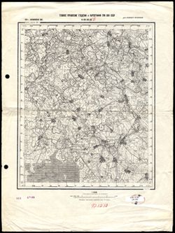
Главное Управление Геодезии и Картографии при СНК СССР
Remove constraint Publisher: Главное Управление Геодезии и Картографии при СНК СССР
Search Results
-
- Description:
- 1940
- Subject:
- Geographic Subject: Belaya, Topical Subject: Maps, and Topical Subject: Soviet Union
- Publisher:
- Главное Управление Геодезии и Картографии при СНК СССР
- Language:
- Russian
- Date Created:
- 1941
- Identifier:
- VAC9619-003279
- Genre:
- Military Maps and Topographic Maps
- Geographic Location:
- Coordinates: 51, 35.5, 51.333, 36
- Related URL:
- Catalog URL: https://iucat.iu.edu/catalog/5020129 and Download GeoTIFF: https://drive.google.com/file/d/1jm7cTC_vuDxY7J3Zj73fN0OM11gGtUh1/view?usp=sharing
- Abstract:
- Modern area represented: Belaya, Kursk oblast, Russia
- Call Number:
- G7000 s100 .S7 sheet M-36-36
- City:
- Белая (Belaya)
- Copyright Holder:
- No Copyright - United States
- Country:
- СССР (USSR)
- State/Province:
- Курская область (Kursk oblast) and РСФСР (RSFSR)
- Physical Description:
- Scale: 1:100,000
- Persistent URL:
- http://purl.dlib.indiana.edu/iudl/images/VAC9619/VAC9619-003279
- Provenance:
- DMA Topographic Center, Army Map Service Library
-
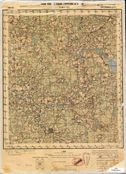
- Description:
- 1939
- Subject:
- Geographic Subject: Sudzha, Topical Subject: Maps, and Topical Subject: Soviet Union
- Publisher:
- Главное Управление Геодезии и Картографии при СНК СССР
- Language:
- Russian
- Date Created:
- 1941
- Identifier:
- VAC9619-003278
- Genre:
- Military Maps and Topographic Maps
- Geographic Location:
- Coordinates: 51, 35, 51.333, 35.5
- Related URL:
- Download GeoTIFF: https://drive.google.com/file/d/1YEenHdsfsIBhqW-cICrUl7cvUJePSbJO/view?usp=sharing and Catalog URL: https://iucat.iu.edu/catalog/5020129
- Abstract:
- Modern area represented: Sudzha, Kursk oblast, Russia
- Call Number:
- G7000 s100 .S7 sheet M-36-35
- City:
- Суджа (Sudzha)
- Copyright Holder:
- No Copyright - United States
- Country:
- СССР (USSR)
- State/Province:
- РСФСР (RSFSR), Сумская область (Sumy oblast), Украинская ССР (Ukrainian Soviet Socialist Republic), and Курская область (Kursk oblast)
- Physical Description:
- Scale: 1:100,000
- Persistent URL:
- http://purl.dlib.indiana.edu/iudl/images/VAC9619/VAC9619-003278
- Provenance:
- DMA Topographic Center, Auswärtiges Amt. Geographischer Dienst, Army Map Service Library
-
- Description:
- 1938
- Subject:
- Geographic Subject: Khotin, Topical Subject: Soviet Union, and Topical Subject: Maps
- Publisher:
- Главное Управление Геодезии и Картографии при СНК СССР
- Language:
- Russian
- Date Created:
- 1941
- Identifier:
- VAC9619-003277
- Genre:
- Military Maps and Topographic Maps
- Geographic Location:
- Coordinates: 51, 34.5, 51.333, 35
- Related URL:
- Download GeoTIFF: https://drive.google.com/file/d/13__g-nTLeVPp1DfWoC52MRNrfC4Ny2Q1/view?usp=sharing and Catalog URL: https://iucat.iu.edu/catalog/5020129
- Abstract:
- Modern area represented: Khotin, Sumy oblast, Ukraine
- Call Number:
- G7000 s100 .S7 sheet M-36-34
- City:
- Хотень (Khotin)
- Copyright Holder:
- No Copyright - United States
- Country:
- СССР (USSR)
- State/Province:
- Сумская область (Sumy oblast), Курская область (Kursk oblast), Украинская ССР (Ukrainian Soviet Socialist Republic), and РСФСР (RSFSR)
- Physical Description:
- Scale: 1:100,000
- Persistent URL:
- http://purl.dlib.indiana.edu/iudl/images/VAC9619/VAC9619-003277
- Provenance:
- DMA Topographic Center, Army Map Service Library
-
- Description:
- 1940
- Subject:
- Geographic Subject: Uspenskoye, Topical Subject: Maps, and Topical Subject: Soviet Union
- Publisher:
- Главное Управление Геодезии и Картографии при СНК СССР
- Language:
- Russian
- Date Created:
- 1941
- Identifier:
- VAC9619-003269
- Genre:
- Military Maps and Topographic Maps
- Geographic Location:
- Coordinates: 51.333, 35.5, 51.667, 36
- Related URL:
- Catalog URL: https://iucat.iu.edu/catalog/5020129 and Download GeoTIFF: https://drive.google.com/file/d/13H2_z6iANzkTqQ8UbHlKPgALvELxyv5l/view?usp=sharing
- Abstract:
- Modern area represented: Uspenskoye, Kursk oblast, Russia
- Call Number:
- G7000 s100 .S7 sheet M-36-24
- Caption:
- Для служебного пользования
- City:
- Успенское (Uspenskoye)
- Copyright Holder:
- No Copyright - United States
- Country:
- СССР (USSR)
- State/Province:
- Курская область (Kursk oblast) and РСФСР (RSFSR)
- Physical Description:
- Scale: 1:100,000
- Persistent URL:
- http://purl.dlib.indiana.edu/iudl/images/VAC9619/VAC9619-003269
- Provenance:
- DMA Topographic Center, Army Map Service Library, OMAHA, Library of Congress Geography & Map Division
-
- Description:
- 1938
- Subject:
- Geographic Subject: Kolezhma, Topical Subject: Maps, and Topical Subject: Soviet Union
- Publisher:
- Главное Управление Геодезии и Картографии при СНК СССР
- Language:
- Russian
- Date Created:
- 1941
- Identifier:
- VAC9619-002629
- Genre:
- Military Maps and Topographic Maps
- Geographic Location:
- Coordinates: 64, 35.5, 64.333, 36
- Related URL:
- Catalog URL: https://iucat.iu.edu/catalog/5020129 and Download GeoTIFF: https://drive.google.com/file/d/1UTip26nPXX54soudKYxJfU64NIEZnnyK/view?usp=sharing
- Abstract:
- Modern area represented: Kolezhma, Republic of Karelia, Russia
- Call Number:
- G7000 s100 .S7 sheet Q-36-144
- Caption:
- Для служебного пользования
- City:
- Колежма (Kolezhma)
- Copyright Holder:
- No Copyright - United States
- Country:
- СССР (USSR)
- State/Province:
- Карело-Финская ССР (Karelo-Finnish Soviet Socialist Republic)
- Physical Description:
- Scale: 1:100,000
- Persistent URL:
- http://purl.dlib.indiana.edu/iudl/images/VAC9619/VAC9619-002629
- Provenance:
- DMA Topographic Center, Army Map Service Library, OMAHA, Geographic Names Branch
-
- Description:
- 1938
- Subject:
- Topical Subject: Soviet Union, Geographic Subject: Bolshoye Ploskoye, and Topical Subject: Maps
- Publisher:
- Главное Управление Геодезии и Картографии при СНК СССР
- Language:
- Russian
- Date Created:
- 1941
- Identifier:
- VAC9619-002730
- Genre:
- Topographic Maps and Military Maps
- Geographic Location:
- 57.666667, 35.5 and Coordinates: 57.5, 35.25
- Related URL:
- Download GeoTIFF: https://drive.google.com/file/d/1O9oNQ-2N946R7PqSKefXi5RLKUZDzqDx/view?usp=sharing and Catalog URL: http://iucat.iu.edu/catalog/5020131
- Abstract:
- Modern area represented: Bolshoye Ploskoye, Tver oblast, Russia
- Call Number:
- G7000 s50 .S68 sheet O-36-95-B
- Caption:
- Для служебного пользования
- Copyright Holder:
- No Copyright - United States
- Country:
- СССР (USSR)
- State/Province:
- РСФСР (RSFSR) and Калининская область (Kalinin oblast)
- Physical Description:
- Scale: 1:50,000
- Persistent URL:
- http://purl.dlib.indiana.edu/iudl/images/VAC9619/VAC9619-002730
- Provenance:
- Library of Congress Geography & Map Division
-
- Description:
- 1938
- Subject:
- Topical Subject: Maps, Geographic Subject: Vasilyevo, and Topical Subject: Soviet Union
- Publisher:
- Главное Управление Геодезии и Картографии при СНК СССР
- Language:
- Russian
- Date Created:
- 1941
- Identifier:
- VAC9619-001873
- Genre:
- Military Maps and Topographic Maps
- Geographic Location:
- Coordinates: 55.1667, 36, 55.3333, 36.25
- Related URL:
- Download GeoTIFF: https://drive.google.com/open?id=1K6w6CW9dTrPwudpPrBYVpbWjdNeeC133 and Catalog URL: http://iucat.iu.edu/catalog/5020131
- Abstract:
- Modern area represented: Vasilyevo, Russia
- Call Number:
- G7000 s50 .S68 sheet N-37-25-A
- City:
- Васильево (Vasilyevo)
- Copyright Holder:
- No Copyright - United States
- Country:
- СССР (USSR)
- State/Province:
- Московская область (Moscow oblast), РСФСР (RSFSR), and Смоленская область (Smolensk oblast)
- Physical Description:
- Scale: 1:50,000
- Persistent URL:
- http://purl.dlib.indiana.edu/iudl/images/VAC9619/VAC9619-001873
- Provenance:
- DMA Topographic Center, Army Map Service Library, OMAHA, Library of Congress Geography & Map Division
-
- Subject:
- Topical Subject: Soviet Union, Topical Subject: Maps, and Geographic Subject: Ruza
- Publisher:
- Главное Управление Геодезии и Картографии при СНК СССР
- Language:
- Russian
- Date Created:
- 1941
- Identifier:
- VAC9619-001988
- Genre:
- Military Maps and Topographic Maps
- Geographic Location:
- Coordinates: 55.6667, 36, 56, 36.5
- Related URL:
- Download GeoTIFF: https://drive.google.com/open?id=183z014zc6Fo65VnpwC5QfH0wkSz1d_qH and Catalog URL: https://iucat.iu.edu/catalog/5020129
- Abstract:
- Modern area represented: Ruza, Moscow oblast, Russia
- Call Number:
- G7000 s100 .S7 sheet N-37-1
- Caption:
- Для служебного пользования
- City:
- Руза (Ruza)
- Copyright Holder:
- No Copyright - United States
- Country:
- СССР (USSR)
- State/Province:
- Московская область (Moscow oblast) and РСФСР (RSFSR)
- Physical Description:
- Scale: 1:100,000
- Persistent URL:
- http://purl.dlib.indiana.edu/iudl/images/VAC9619/VAC9619-001988
- Provenance:
- DMA Topographic Center, Army Map Service Library, Geographic Names Branch, OMAHA
-
- Description:
- 1934
- Subject:
- Topical Subject: Soviet Union, Topical Subject: Maps, and Geographic Subject: Noviy Azov
- Publisher:
- Главное Управление Геодезии и Картографии при СНК СССР
- Language:
- Russian
- Date Created:
- 1936
- Identifier:
- VAC9619-001924
- Genre:
- Topographic Maps and Military Maps
- Geographic Location:
- Coordinates: 46, 35, 46.3333, 35.5
- Related URL:
- Download GeoTIFF: https://drive.google.com/open?id=1kXYrv1G8OZSvZdSM2SJdkDOcDlraF50I and Catalog URL: https://iucat.iu.edu/catalog/5020129
- Abstract:
- Modern area represented: Noviy Azov, Kherson oblast, Ukraine
- Call Number:
- G7000 s100 .S7 sheet L-36-71
- Caption:
- Для служебного пользования
- City:
- Нов. Азов (Noviy Azov)
- Copyright Holder:
- No Copyright - United States
- Country:
- СССР (USSR)
- State/Province:
- Запорожская область (Zaporizhia oblast) and Украинская ССР (Ukrainian Soviet Socialist Republic)
- Physical Description:
- Scale: 1:100,000
- Persistent URL:
- http://purl.dlib.indiana.edu/iudl/images/VAC9619/VAC9619-001924
- Provenance:
- CIA Map Library
-
- Description:
- 1934
- Subject:
- Topical Subject: Maps, Geographic Subject: Okhrimivka, and Topical Subject: Soviet Union
- Publisher:
- Главное Управление Геодезии и Картографии при СНК СССР
- Language:
- Russian
- Date Created:
- 1941
- Identifier:
- VAC9619-001913
- Genre:
- Military Maps and Topographic Maps
- Geographic Location:
- Coordinates: 46.3333, 35, 46.6667, 35.5
- Related URL:
- Catalog URL: https://iucat.iu.edu/catalog/5020129 and Download GeoTIFF: https://drive.google.com/open?id=1eqKwauRt9y66nxYzOrAKEMy6XqSJedsf
- Abstract:
- Modern area represented: Okhrimivka, Zaporizhia oblast, Ukraine
- Call Number:
- G7000 s100 .S7 sheet L-36-59
- Caption:
- Для служебного пользования
- City:
- Ефремовка (Yefremovka)
- Copyright Holder:
- No Copyright - United States
- Country:
- СССР (USSR)
- State/Province:
- Запорожская область (Zaporizhia oblast), Украинская ССР (Ukrainian Soviet Socialist Republic), Приазовский район (Pryazovsky district), Генический район (Hen...
- Physical Description:
- Scale: 1:100,000
- Persistent URL:
- http://purl.dlib.indiana.edu/iudl/images/VAC9619/VAC9619-001913
- Provenance:
- DMA Topographic Center, Army Map Service Library, OMAHA
-
- Description:
- 1931
- Subject:
- Topical Subject: Maps, Geographic Subject: Zhidilovka, and Topical Subject: Soviet Union
- Publisher:
- Главное Управление Геодезии и Картографии при СНК СССР
- Language:
- Russian
- Date Created:
- 1933
- Identifier:
- VAC9619-001656
- Genre:
- Topographic Maps and Military Maps
- Geographic Location:
- Coordinates: 52.5, 52.25, 52.667, 52.5
- Related URL:
- Catalog URL: http://iucat.iu.edu/catalog/5020131 and Download GeoTIFF: https://drive.google.com/open?id=1HNPlbss41O64cg3X6XTm_EwuMiWCCZsX
- Abstract:
- Modern area represented: Zhidilovka, Orenburg oblast, Russia
- Call Number:
- G7000 s50 .S68 sheet N-39-129-B
- City:
- Жидиловка (Zhidilovka)
- Copyright Holder:
- No Copyright - United States
- Country:
- СССР (USSR)
- State/Province:
- РСФСР (RSFSR) and Чкаловская область (Chkalov oblast)
- Physical Description:
- Scale: 1:50,000
- Persistent URL:
- http://purl.dlib.indiana.edu/iudl/images/VAC9619/VAC9619-001656
- Provenance:
- CIA Map Library
-

- Description:
- 1940
- Subject:
- Topical Subject: Maps, Geographic Subject: Volovo, and Topical Subject: Soviet Union
- Publisher:
- Главное Управление Геодезии и Картографии при СНК СССР
- Language:
- Russian
- Date Created:
- 1941
- Identifier:
- VAC9619-001634
- Genre:
- Military Maps and Topographic Maps
- Geographic Location:
- Coordinates: 52, 37.75, 52.167, 38
- Related URL:
- Download GeoTIFF: https://drive.google.com/open?id=1Y2T-2H0oNJDMUHh9pMmjVVwqt2WaYCUg and Catalog URL: http://iucat.iu.edu/catalog/5020131
- Abstract:
- Modern area represented: Volovo, Oryol oblast, Russia
- Call Number:
- G7000 s50 .S68 sheet N-37-136-C
- Caption:
- Для служебного пользования
- City:
- Волово (Volovo)
- Copyright Holder:
- No Copyright - United States
- Country:
- СССР (USSR)
- State/Province:
- Курская область (Kursk oblast), РСФСР (RSFSR), and Орловская область (Oryol oblast)
- Physical Description:
- Scale: 1:50,000
- Persistent URL:
- http://purl.dlib.indiana.edu/iudl/images/VAC9619/VAC9619-001634
- Provenance:
- DMA Topographic Center, Army Map Service Library, OMAHA, Library of Congress Geography & Map Division
-
- Description:
- 1940
- Subject:
- Topical Subject: Maps, Geographic Subject: Vyshneye Olshanoye, and Topical Subject: Soviet Union
- Publisher:
- Главное Управление Геодезии и Картографии при СНК СССР
- Language:
- Russian
- Date Created:
- 1941
- Identifier:
- VAC9619-001633
- Genre:
- Topographic Maps and Military Maps
- Geographic Location:
- Coordinates: 52, 37.5, 52.167, 37.75
- Related URL:
- Download GeoTIFF: https://drive.google.com/open?id=1-gQWC7au61DmD7m8v6w1UAehnLXS2qrn and Catalog URL: http://iucat.iu.edu/catalog/5020131
- Abstract:
- Modern area represented: Vyshneye Olshanoye, Oryol oblast, Russia
- Call Number:
- G7000 s50 .S68 sheet N-37-136-C
- Caption:
- Для служебного пользования
- City:
- Верх. Ольшаное (Vyshneye Olshanoye)
- Copyright Holder:
- No Copyright - United States
- Country:
- СССР (USSR)
- State/Province:
- РСФСР (RSFSR), Орловская область (Oryol oblast), and Курская область (Kursk oblast)
- Physical Description:
- Scale: 1:50,000
- Persistent URL:
- http://purl.dlib.indiana.edu/iudl/images/VAC9619/VAC9619-001633
- Provenance:
- DMA Topographic Center, Army Map Service Library, OMAHA, Library of Congress Geography & Map Division
-
- Description:
- 1940
- Subject:
- Topical Subject: Soviet Union, Topical Subject: Maps, and Geographic Subject: Nikolskoye
- Publisher:
- Главное Управление Геодезии и Картографии при СНК СССР
- Language:
- Russian
- Date Created:
- 1941
- Identifier:
- VAC9619-001632
- Genre:
- Topographic Maps and Military Maps
- Geographic Location:
- Coordinates: 52.167, 37.5, 52.333, 37.75
- Related URL:
- Download GeoTIFF: https://drive.google.com/open?id=1LpITcasavTiLEoqhkqPG3ba9w3V9zKxO and Catalog URL: http://iucat.iu.edu/catalog/5020131
- Abstract:
- Modern area represented: Nikolskoye, Oryol oblast, Russia
- Call Number:
- G7000 s50 .S68 sheet N-37-136-A
- Caption:
- Для служебного пользования
- City:
- Никольское (Nikolskoye)
- Copyright Holder:
- No Copyright - United States
- Country:
- СССР (USSR)
- State/Province:
- Орловская область (Oryol oblast) and РСФСР (RSFSR)
- Physical Description:
- Scale: 1:50,000
- Persistent URL:
- http://purl.dlib.indiana.edu/iudl/images/VAC9619/VAC9619-001632
- Provenance:
- DMA Topographic Center, Army Map Service Library, OMAHA, Library of Congress Geography & Map Division
-
- Description:
- 1940
- Subject:
- Topical Subject: Maps, Geographic Subject: Khomutovo, and Topical Subject: Soviet Union
- Publisher:
- Главное Управление Геодезии и Картографии при СНК СССР
- Language:
- Russian
- Date Created:
- 1941
- Identifier:
- VAC9619-001628
- Genre:
- Military Maps and Topographic Maps
- Geographic Location:
- Coordinates: 52.833, 37.25, 53, 37.5
- Related URL:
- Download GeoTIFF: https://drive.google.com/open?id=1SIcg4a5irHJ_MFTIR7u4EicOX4Ws3Awe and Catalog URL: http://iucat.iu.edu/catalog/5020131
- Abstract:
- Modern area represented: Khomutovo, Oryol oblast, Russia
- Call Number:
- G7000 s50 .S68 sheet N-37-111-B
- Caption:
- Для служебного пользования
- City:
- Хомутово (Khomutovo)
- Copyright Holder:
- No Copyright - United States
- Country:
- СССР (USSR)
- State/Province:
- Орловская область (Oryol oblast) and РСФСР (RSFSR)
- Physical Description:
- Scale: 1:50,000
- Persistent URL:
- http://purl.dlib.indiana.edu/iudl/images/VAC9619/VAC9619-001628
- Provenance:
- DMA Topographic Center, Army Map Service Library, OMAHA, Library of Congress Geography & Map Division
-
- Description:
- 1932
- Subject:
- Geographic Subject: Novosil, Topical Subject: Soviet Union, and Topical Subject: Maps
- Publisher:
- Главное Управление Геодезии и Картографии при СНК СССР
- Language:
- Russian
- Date Created:
- 1941
- Identifier:
- VAC9619-001627
- Genre:
- Topographic Maps and Military Maps
- Geographic Location:
- Coordinates: 52.833, 37, 53, 37.25
- Related URL:
- Download GeoTIFF: https://drive.google.com/open?id=1r4rcYgTn5yNIEhiZBIkimBCF43d0UQ36 and Catalog URL: http://iucat.iu.edu/catalog/5020131
- Abstract:
- Modern area represented: Novosil, Oryol oblast, Russia
- Call Number:
- G7000 s50 .S68 sheet N-37-111-A
- Caption:
- Для служебного пользования
- City:
- Новосиль (Novosil)
- Copyright Holder:
- No Copyright - United States
- Country:
- СССР (USSR)
- State/Province:
- Орловская область (Oryol oblast) and РСФСР (RSFSR)
- Physical Description:
- Scale: 1:50,000
- Persistent URL:
- http://purl.dlib.indiana.edu/iudl/images/VAC9619/VAC9619-001627
- Provenance:
- DMA Topographic Center, Army Map Service Library, OMAHA, Library of Congress Geography & Map Division
-
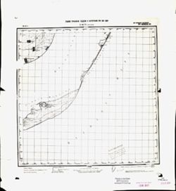
- Description:
- 1940
- Subject:
- Geographic Subject: Verkhniy Putimets, Topical Subject: Soviet Union, and Topical Subject: Maps
- Publisher:
- Главное Управление Геодезии и Картографии при СНК СССР
- Language:
- Russian
- Date Created:
- 1941
- Identifier:
- VAC9619-001626
- Genre:
- Topographic Maps and Military Maps
- Geographic Location:
- Coordinates: 52.667, 36, 52.833, 36.25
- Related URL:
- Download GeoTIFF: https://drive.google.com/open?id=1aVdwKqdSBEslZybbOLXcYgSdGSdInumP and Catalog URL: http://iucat.iu.edu/catalog/5020131
- Abstract:
- Modern area represented: Putimets, Oryol oblast, Russia
- Call Number:
- G7000 s50 .S68 sheet N-37-109-C
- City:
- Верх. Путимец (Verkhniy Putimets)
- Copyright Holder:
- No Copyright - United States
- Country:
- СССР (USSR)
- State/Province:
- Орловская область (Oryol oblast) and РСФСР (RSFSR)
- Physical Description:
- Scale: 1:50,000
- Persistent URL:
- http://purl.dlib.indiana.edu/iudl/images/VAC9619/VAC9619-001626
- Provenance:
- DMA Topographic Center, Army Map Service Library, OMAHA, Library of Congress Geography & Map Division
-
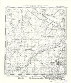
- Description:
- 1940
- Subject:
- Geographic Subject: Stupino, Topical Subject: Maps, and Topical Subject: Soviet Union
- Publisher:
- Главное Управление Геодезии и Картографии при СНК СССР
- Language:
- Russian
- Date Created:
- 1941
- Identifier:
- VAC9619-001623
- Genre:
- Topographic Maps and Military Maps
- Geographic Location:
- Coordinates: 53, 38.5, 53.167, 38.75
- Related URL:
- Catalog URL: http://iucat.iu.edu/catalog/5020131 and Download GeoTIFF: https://drive.google.com/open?id=1C2uBAjzOdynUSngaB0U0KXhHqcPwi00-
- Abstract:
- Modern area represented: Stupino, Tula oblast, Russia
- Call Number:
- G7000 s50 .S68 sheet N-37-102-В
- Caption:
- Для служебного пользования
- City:
- Ступино (Stupino)
- Copyright Holder:
- No Copyright - United States
- Country:
- СССР (USSR)
- State/Province:
- Орловская область (Oryol oblast), РСФСР (RSFSR), Тульская область (Tula oblast), and Рязанская область (Ryazan oblast)
- Physical Description:
- Scale: 1:50,000
- Persistent URL:
- http://purl.dlib.indiana.edu/iudl/images/VAC9619/VAC9619-001623
- Provenance:
- DMA Topographic Center, Army Map Service Library, OMAHA, Library of Congress Geography & Map Division
-
- Description:
- 1940
- Subject:
- Topical Subject: Maps, Topical Subject: Soviet Union, and Geographic Subject: Teploye
- Publisher:
- Главное Управление Геодезии и Картографии при СНК СССР
- Language:
- Russian
- Date Created:
- 1941
- Identifier:
- VAC9619-001622
- Genre:
- Topographic Maps and Military Maps
- Geographic Location:
- Coordinates: 53.167, 38.75, 53.333, 39
- Related URL:
- Catalog URL: http://iucat.iu.edu/catalog/5020131 and Download GeoTIFF: https://drive.google.com/open?id=1lM9vz8ka8KBnG2SoG43x4qVhM7_1oZq1
- Abstract:
- Modern area represented: Teploye, Lipetsk oblast, Russia
- Call Number:
- G7000 s50 .S68 sheet N-37-102-B
- Caption:
- Для служебного пользования
- City:
- Теплое (Teploye)
- Copyright Holder:
- No Copyright - United States
- Country:
- СССР (USSR)
- State/Province:
- РСФСР (RSFSR) and Рязанская область (Ryazan oblast)
- Physical Description:
- Scale: 1:50,000
- Persistent URL:
- http://purl.dlib.indiana.edu/iudl/images/VAC9619/VAC9619-001622
- Provenance:
- DMA Topographic Center, Army Map Service Library, OMAHA, Library of Congress Geography & Map Division
-
- Description:
- 1940
- Subject:
- Topical Subject: Maps, Geographic Subject: Voskresenskoye, and Topical Subject: Soviet Union
- Publisher:
- Главное Управление Геодезии и Картографии при СНК СССР
- Language:
- Russian
- Date Created:
- 1941
- Identifier:
- VAC9619-001621
- Genre:
- Topographic Maps and Military Maps
- Geographic Location:
- Coordinates: 53.167, 38.5, 53.333, 38.75
- Related URL:
- Download GeoTIFF: https://drive.google.com/open?id=1P42W8VzHcjf1s09sLj4-0gdmibUZvSEx and Catalog URL: http://iucat.iu.edu/catalog/5020131
- Abstract:
- Modern area represented: Voskresenskoye, Lipetsk oblast, Russia
- Call Number:
- G7000 s50 .S68 sheet N-37-102-A
- Caption:
- Для служебного пользования
- City:
- Воскресенское (Voskresenskoye)
- Copyright Holder:
- No Copyright - United States
- Country:
- СССР (USSR)
- State/Province:
- РСФСР (RSFSR), Тульская область (Tula oblast), and Рязанская область (Ryazan oblast)
- Physical Description:
- Scale: 1:50,000
- Persistent URL:
- http://purl.dlib.indiana.edu/iudl/images/VAC9619/VAC9619-001621
- Provenance:
- DMA Topographic Center, Army Map Service Library, Library of Congress Geography & Map Division
