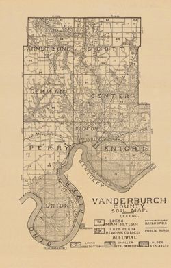
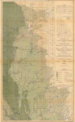
Shows railroads and public roads. Detached from: A soil survey of Vanderburgh, Gibson, and Pike, and parts of Warrick and Spencer counties / Chas. W. Shan...
Call Number:
G4093.V3J3 1909 .S5
Caption:
Imprint: [Indianapolis] : [Indiana Department of Geology and Natural Resources], [1910]
Physical Description:
Dimensions: 37 x 24 cm and Scale: Approximately 1:126,720
Alternate Identifier:
Alternate ID: 390726IP and Title Control Number: a16123565
Topical Subject: Limestone, Topical Subject: Geology, Geographic Subject: Owen County (Ind.), Geographic Subject: Monroe County (Ind.), and Topical Subject: ...
Creator:
Siebenthal, C. E. (Claude Ellsworth), 1869-1930
Publisher:
Indiana. Department of Geology and Natural Resources
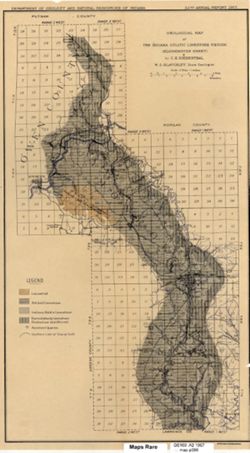
Also shows location of lacustral, Mitchell limestone, and Harrodsburg limestone as well as those of abandoned quarries and the southern limit of glacial drif...
Call Number:
G4093.M7H5 1907 .S5
Caption:
Imprint: [Indianapolis] : [Indiana Dept. of Geology and Natural Resources], [1908]
Physical Description:
Scale: Approximately 1:126,720. 2 miles = 1 inches and Dimensions: 44 x 25 cm
Alternate Identifier:
Alternate ID: 390726IP and Title Control Number: a18307460
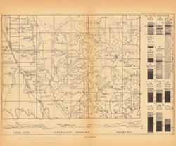
Relief shown by profile. 13 columnar sections showing coal measures and location map for Jefferson Township, including Coal City and Arney, in Owen County, I...
Call Number:
G4094.J384H9 1898 .C63
Caption:
Imprint: [Indianapolis] : [Wm. B. Burford], [1899] and Imprint: [Indianapolis] : [Indiana, Dept. of Geology and Natural History], [1899]
Physical Description:
Dimensions: 23 x 27 cm and Scale: Approximately 1:63,360. Vertical scale varies
Alternate Identifier:
Alternate ID: 390726IP and Title Control Number: a18418134
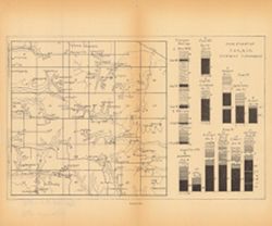
13 columnar sections showing coal measures with location map for Wright Township in Greene County, Indiana. Plate XL. Detached from: The coal deposits of ...
Call Number:
G4094.W79H9 1898 .I5
Caption:
Imprint: [Indianapolis] : [Wm. B. Burford], [1899] and Imprint: [Indianapolis] : [Indiana. Department of Geology and Natural Resources], [1899]
Physical Description:
Dimensions: 23 x 27 cm and Scale: Approximately 1:63,360. Vertical scale varies
Alternate Identifier:
Alternate ID: 390726IP and Title Control Number: a18417962
Topical Subject: Gravel, Geographic Subject: Switzerland County (Ind.), Geographic Subject: Dearborn County (Ind.), Geographic Subject: Jefferson County (Ind...
Publisher:
Indiana. Department of Geology and Natural Resources
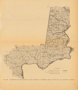
Title from caption. At head of title: Fig. 48A. Shows gravel locations. Detached from: The roads and road materials of a portion of southwestern Indiana /...
Call Number:
QE109 .A2 1905 map p766
Caption:
Imprint: [Indianapolis] : [Indiana Dept. of Geology and Natural Resources], [1906]
Physical Description:
Scale: Approximately 1:410,000 and Dimensions: on sheet 26 x 23 cm
Alternate Identifier:
Title Control Number: a18299070 and Alternate ID: 390726IP
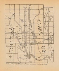
Shows the location of clay and shale deposits as well as the locations of brick, clay works, and tile companies. At head of title: Fig. 5. "R.S.B. Del.&...
Call Number:
G4094.M68H5 1904 .V53
Caption:
Imprint: [Indianapolis] : [Wm. B. Burford], [1905] and Imprint: [Indianapolis] : [Indiana Department of Geology and Natural Resources], [1905]
Physical Description:
Dimensions: 23 x 19 cm and Scale: Approximately 1:53,000
Alternate Identifier:
Alternate ID: 390726IP and Title Control Number: a18282337
Geographic Subject: Union County (Ind.), Geographic Subject: Franklin County (Ind.), Topical Subject: IGS Annual Reports, Geographic Subject: Indiana, Topica...
Publisher:
Indiana. Department of Geology and Natural Resources
Date Created:
1908
Identifier:
VAC3073-M-00272
Genre:
Geological maps
Related URL:
Catalog URL: https://iucat.iu.edu/catalog/9676901
Abstract:
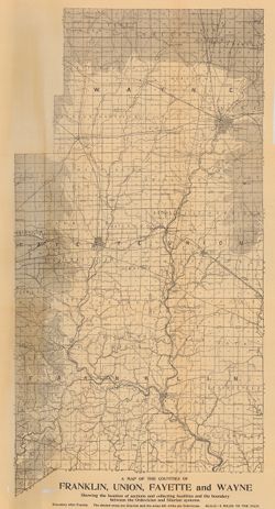
Showing the Location of sections and collecting localities and the boundary between the Ordovician and Silurian Systems. Detached from: The stratigraphy a...
Call Number:
QE109 .A2 1907 map p605
Caption:
Imprint: Indianapolis : 1908
Physical Description:
Dimensions: 67 x 37 cm and Scale: Approximately 1:126,720. 2 miles = 1 inch
Plate XIX. Planned and laid out by P.J. Mooney , drawn by G.H.A. Detached from: The coal deposits of Indiana / George Hall Ashley. In Indiana Dept. of Geo...
Call Number:
G4093.C5H9 1898 .A8
Caption:
Imprint: [Indianapolis] : [Dept. of Geology and Natural Resources of Indiana], [1899]
Physical Description:
Dimensions: 22 x 26 cm and Scale: Approximately 1:2,400
Alternate Identifier:
Title Control Number: a18244670 and Alternate ID: 390726IP
Geographic Subject: Putnam County (Ind.), Geographic Subject: Benton County (Ind.), Geographic Subject: Fountain County (Ind.), Geographic Subject: Newton Co...
Creator:
Ashley, Geo. H. (George Hall), 1866-1951, Siebenthal, C. E. (Claude Ellsworth), 1869-1930, and Kindle, E. M. (Edward Martin), 1869-1940
Publisher:
Indiana. Department of Geology and Natural Resources
Relief shown by spot heights. Includes map showing coal locations and features, railroads, and quarries as well as two inset maps for parts of Newton and Ben...
Call Number:
G4093.W3H9 1898 .A84
Caption:
Imprint: Indianapolis, Ind. : Wm. B. Burford, [1899]
Physical Description:
Dimensions: 79 x 48 cm and Scale: Approximately 1:126,720. 2 miles = 1 inch
Alternate Identifier:
Alternate ID: 390726IP and Title Control Number: a18265361
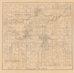
Shows wells drilling, wells producing oil, wells producing oil and gas, wells plugged or abandoned, dry wells, wells drilled in 1891, and power houses. Also ...
Call Number:
G4093.G5H8 1906 .B5
Caption:
Imprint: [Indianapolis] : [Wm. B. Burford], [1907] and Imprint: [Indianapolis] : [Indiana Department of Geology and Natural Resources], [1907]
Physical Description:
Dimensions: 44 x 47 cm and Scale: Approximately 1:126,720. 2 miles = 1 inch
Alternate Identifier:
Alternate ID: 390726IP and Title Control Number: a16160959