
Search Constraints
You searched for:
State/Province
РСФСР (RSFSR)
Remove constraint State/Province: РСФСР (RSFSR)
« Previous |
1 - 100 of 1,385
|
Next »
Search Results
-
- Description:
- 1926
- Subject:
- Topical Subject: Soviet Union, Geographic Subject: Usvyata, and Topical Subject: Maps
- Publisher:
- Генеральный штаб РККА
- Language:
- Russian
- Identifier:
- VAC9619-001185
- Genre:
- Military Maps and Topographic Maps
- Geographic Location:
- Coordinates: 55.6667, 30.75, 55.8333, 31
- Related URL:
- Catalog URL: http://iucat.iu.edu/catalog/5020131 and Download GeoTIFF: https://drive.google.com/open?id=1LfDnjyQimu1w-GGzLKdUvdo_k8BYoSs-
- Abstract:
- Modern area represented: Usvyata, Pskov oblast, Russia
- Call Number:
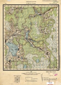
- GM G7000 S50 .S68 Т-36-2-Г
- Caption:
- Не подлежит оглашению
- City:
- Усвяты (Usvyata)
- Copyright Holder:
- No Copyright - United States
- Country:
- СССР (USSR)
- State/Province:
- РСФСР (RSFSR) and Смоленская область (Smolensk oblast)
- Physical Description:
- Scale: 1:50,000
- Persistent URL:
- http://purl.dlib.indiana.edu/iudl/images/VAC9619/VAC9619-001185
- Provenance:
- Library of Congress Geography & Map Division
-
- Description:
- 1940
- Subject:
- Topical Subject: Maps, Geographic Subject: Maksatikha, and Topical Subject: Soviet Union
- Publisher:
- Генеральный штаб Красной Армии
- Language:
- Russian
- Identifier:
- VAC9619-002184
- Genre:
- Military Maps and Topographic Maps
- Geographic Location:
- Coordinates: 57.6667, 35.5, 58, 36
- Related URL:
- Catalog URL: https://iucat.iu.edu/catalog/5020129 and Download GeoTIFF: https://drive.google.com/open?id=1CKFdsVz29XV7lHDHDemuQoskFHRfscCM
- Abstract:
- Modern area represented: Максатиха (Maksatikha), Tverskaya oblast, Russia
- Call Number:
- G7000 s100 .S7 sheet О-36-84
- Caption:
- Временное издание
- City:
- Максатиха (Maksatikha)
- Copyright Holder:
- No Copyright - United States
- Country:
- СССР (USSR)
- State/Province:
- РСФСР (RSFSR) and Калининская область (Kalinin oblast)
- Physical Description:
- Scale: 1:100,000
- Persistent URL:
- http://purl.dlib.indiana.edu/iudl/images/VAC9619/VAC9619-002184
- Provenance:
- DMA Topographic Center, Army Map Service Library, OMAHA, Library of Congress Geography & Map Division
-
- Description:
- 1939
- Subject:
- Topical Subject: Soviet Union, Geographic Subject: Vaskinichi, and Topical Subject: Maps
- Publisher:
- Главное управление геодезии и картографии при СНК СССР
- Language:
- Russian
- Date Created:
- 1941
- Identifier:
- VAC9619-000009
- Genre:
- Topographic Maps and Military Maps
- Geographic Location:
- Coordinates: 59.6667, 32.75, 59.8333, 33
- Related URL:
- Download GeoTIFF: https://drive.google.com/open?id=1EY2ej2jtqUigE6OtBp8sxn3kYNf80HIT and Catalog URL: http://iucat.iu.edu/catalog/5020131
- Abstract:
- Modern area represented: Vaskinichi, Leningrad oblast, Russia
- Call Number:
- G7000 s50 .S68 sheet O-36-6-D
- Caption:
- Секретно,Captured map
- City:
- Васкеничи (Vaskenichi)
- Copyright Holder:
- No Copyright - United States
- Country:
- СССР (USSR)
- State/Province:
- Тихвинский район (Tikhvin district), Ленинградская область (Leningrad oblast), РСФСР (RSFSR), and Волховский район (Volkhov district)
- Physical Description:
- Scale: 1:50,000
- Persistent URL:
- http://purl.dlib.indiana.edu/iudl/images/VAC9619/VAC9619-000009
- Provenance:
- DMA Topographic Center, Army Map Service Library, OMAHA, Library of Congress Geography & Map Division
-
- Description:
- 1939
- Subject:
- Geographic Subject: Bezovo and Topical Subject: Soviet Union
- Publisher:
- Главное управление геодезии и картографии при СНК СССР
- Language:
- Russian
- Date Created:
- 1941
- Identifier:
- VAC9619-000002
- Genre:
- Topographic Maps and Military Maps
- Geographic Location:
- Coordinates: 59.6667, 32.5, 59.8333, 32.75
- Related URL:
- Download GeoTIFF: https://drive.google.com/open?id=1mChk164lKHS7pE139ijCnFaNrOaNCvUp and Catalog URL: http://iucat.iu.edu/catalog/5020131
- Abstract:
- Modern area represented: Bezovo, Russia
- Call Number:
- G7000 s50 .S68 sheet O-36-6-C
- Caption:
- Секретно,Captured map
- City:
- Безово (Bezovo)
- Copyright Holder:
- No Copyright - United States
- Country:
- СССР (USSR)
- State/Province:
- Ленинградская область (Leningrad oblast), РСФСР (RSFSR), Тихвинский район (Tikhvin district), and Волховский район (Volkhov district)
- Physical Description:
- Scale: 1:50,000
- Persistent URL:
- http://purl.dlib.indiana.edu/iudl/images/VAC9619/VAC9619-000002
- Provenance:
- DMA Topographic Center, Army Map Service Library, Library of Congress Geography & Map Division
-
- Description:
- 1939
- Subject:
- Topical Subject: Maps, Topical Subject: Soviet Union, and Geographic Subject: Prokshenitsy
- Publisher:
- Главное управление геодезии и картографии при СНК СССР
- Language:
- Russian
- Date Created:
- 1941
- Identifier:
- VAC9619-000008
- Genre:
- Topographic Maps and Military Maps
- Geographic Location:
- Coordinates: 59.8333, 32.75, 60, 33
- Related URL:
- Download GeoTIFF: https://drive.google.com/open?id=1uLy73UPhqeb3yZsZ_KDxD-EeVzGdgz3Q and Catalog URL: http://iucat.iu.edu/catalog/5020131
- Abstract:
- Modern area represented: Prokshenitsy, Russia
- Call Number:
- G7000 s50 .S68 sheet O-36-6-B
- Caption:
- Секретно,Captured map
- City:
- Прокшеницы (Prokshenitsy)
- Copyright Holder:
- No Copyright - United States
- Country:
- СССР (USSR)
- State/Province:
- Волховский район (Volkhov district), РСФСР (RSFSR), Ленинградская область (Leningrad oblast), and Тихвинский район (Tikhvin district)
- Physical Description:
- Scale: 1:50,000
- Persistent URL:
- http://purl.dlib.indiana.edu/iudl/images/VAC9619/VAC9619-000008
- Provenance:
- DMA Topographic Center, Army Map Service Library, Library of Congress Geography & Map Division
-
- Description:
- 1939
- Subject:
- Geographic Subject: Polyana and Topical Subject: Soviet Union
- Publisher:
- Главное управление геодезии и картографии при СНК СССР
- Language:
- Russian
- Date Created:
- 1939
- Identifier:
- VAC9619-000007
- Genre:
- Topographic Maps and Military Maps
- Geographic Location:
- Coordinates: 59.6667, 31.25, 59.8333, 31.5
- Related URL:
- Catalog URL: http://iucat.iu.edu/catalog/5020131 and Download GeoTIFF: https://drive.google.com/open?id=1QhVDxDghHww023dj3SHGuFISgFPnOpeM
- Abstract:
- Modern area represented: Polyana, Russia
- Call Number:
- G7000 s50 .S68 sheet O-36-3-D
- City:
- Поляна (Polyana)
- Copyright Holder:
- No Copyright - United States
- Country:
- СССР (USSR)
- State/Province:
- Ленинградская область (Leningrad oblast), Мгинский район (Mginsky district), and РСФСР (RSFSR)
- Physical Description:
- Scale: 1:50,000
- Persistent URL:
- http://purl.dlib.indiana.edu/iudl/images/VAC9619/VAC9619-000007
- Provenance:
- Army Map Service Library, OMAHA, Library of Congress Geography & Map Division
-
- Description:
- 1937
- Subject:
- Topical Subject: Soviet Union, Geographic Subject: Babino, and Topical Subject: Maps
- Publisher:
- Главное управление государственной съемки и картографии НКВД СССР
- Language:
- Russian
- Date Created:
- 1941
- Identifier:
- VAC9619-000044
- Genre:
- Military Maps and Topographic Maps
- Geographic Location:
- Coordinates: 59.1667, 31.25, 59.3333, 31.5
- Related URL:
- Download GeoTIFF: https://drive.google.com/open?id=117pSSxlZhQGDjutRAtCtoaIqVDkp3Xa0 and Catalog URL: http://iucat.iu.edu/catalog/5020131
- Abstract:
- Modern area represented:
- Call Number:
- G7000 s50 .S68 sheet O-36-27-B
- Caption:
- Секретно,Captured map
- City:
- Бабино (Babino)
- Copyright Holder:
- No Copyright - United States
- Country:
- СССР (USSR)
- State/Province:
- Тосненский район (Tosnensky district), РСФСР (RSFSR), Ленинградская область (Leningrad oblast), and Чудовский район (Chudovsky district)
- Physical Description:
- Scale: 1:50,000
- Persistent URL:
- http://purl.dlib.indiana.edu/iudl/images/VAC9619/VAC9619-000044
- Provenance:
- DMA Topographic Center, Army Map Service Library, OMAHA, Library of Congress Geography & Map Division
-
- Description:
- 1937
- Subject:
- Topical Subject: Soviet Union, Geographic Subject: Korkino, and Topical Subject: Maps
- Publisher:
- Главное управление государственной съемки и картографии НКВД СССР
- Language:
- Russian
- Date Created:
- 1941
- Identifier:
- VAC9619-000043
- Genre:
- Topographic Maps and Military Maps
- Geographic Location:
- Coordinates: 59.1667, 31, 59.3333, 31.25
- Related URL:
- Catalog URL: http://iucat.iu.edu/catalog/5020131 and Download GeoTIFF: https://drive.google.com/open?id=1bsTUMvoE0kAKG1XeVu6aZENX9H3qNZIO
- Abstract:
- Modern area represented: Korkino, Russia
- Call Number:
- G7000 s50 .S68 sheet O-36-27-A
- Caption:
- Для служебного пользования
- City:
- Коркино (Korkino)
- Copyright Holder:
- No Copyright - United States
- Country:
- СССР (USSR)
- State/Province:
- РСФСР (RSFSR), Тосненский район (Tosnensky district), and Ленинградская область (Leningrad oblast)
- Physical Description:
- Scale: 1:50,000
- Persistent URL:
- http://purl.dlib.indiana.edu/iudl/images/VAC9619/VAC9619-000043
- Provenance:
- DMA Topographic Center, Army Map Service Library, OMAHA, Library of Congress Geography & Map Division
-
- Description:
- 1937
- Subject:
- Geographic Subject: Kubolovo, Topical Subject: Soviet Union, and Topical Subject: Maps
- Publisher:
- Главное управление государственной съемки и картографии НКВД СССР
- Language:
- Russian
- Date Created:
- 1941
- Identifier:
- VAC9619-000042
- Genre:
- Topographic Maps and Military Maps
- Geographic Location:
- Coordinates: 59, 30.75, 59.1667, 31
- Related URL:
- Download GeoTIFF: https://drive.google.com/open?id=1Zo_O0BWAAl8rG6V8h9VkfMkerMU104rZ and Catalog URL: http://iucat.iu.edu/catalog/5020131
- Abstract:
- Modern area represented: Kubolovo, Russia
- Call Number:
- G7000 s50 .S68 sheet O-36-26-D
- Caption:
- Секретно,Captured map
- City:
- Куболово (Kubolovo)
- Copyright Holder:
- No Copyright - United States
- Country:
- СССР (USSR)
- State/Province:
- Тосненский район (Tosnensky district), Оредежский район (Oredezhsky district), Ленинградская область (Leningrad oblast), Новгородский район (Novgorod distric...
- Physical Description:
- Scale: 1:50,000
- Persistent URL:
- http://purl.dlib.indiana.edu/iudl/images/VAC9619/VAC9619-000042
- Provenance:
- DMA Topographic Center, Army Map Service Library, OMAHA, Library of Congress Geography & Map Division
-
- Description:
- 1937
- Subject:
- Geographic Subject: Nesterkovo, Topical Subject: Maps, and Topical Subject: Soviet Union
- Publisher:
- Главное управление государственной съемки и картографии НКВД СССР
- Language:
- Russian
- Date Created:
- 1941
- Identifier:
- VAC9619-000041
- Genre:
- Topographic Maps and Military Maps
- Geographic Location:
- Coordinates: 59, 30.5, 59.1667, 30.75
- Related URL:
- Catalog URL: http://iucat.iu.edu/catalog/5020131 and Download GeoTIFF: https://drive.google.com/open?id=15zmLpNAtR49LfgQ9suZDHQMWXpE-EEqP
- Abstract:
- Modern area represented: Nesterkovo, Russia
- Call Number:
- G7000 s50 .S68 sheet O-36-26-C
- Caption:
- Секретно,Captured map
- City:
- Нестерково (Nesterkovo)
- Copyright Holder:
- No Copyright - United States
- Country:
- СССР (USSR)
- State/Province:
- РСФСР (RSFSR), Оредежский район (Oredezhsky district), Тосненский район (Tosnensky district), and Ленинградская область (Leningrad oblast)
- Physical Description:
- Scale: 1:50,000
- Persistent URL:
- http://purl.dlib.indiana.edu/iudl/images/VAC9619/VAC9619-000041
- Provenance:
- DMA Topographic Center, Army Map Service Library, OMAHA, Library of Congress Geography & Map Division
-

- Description:
- 1937
- Subject:
- Geographic Subject: Gummolovo and Topical Subject: Soviet Union
- Publisher:
- Главное управление государственной съемки и картографии НКВД СССР
- Language:
- Russian
- Date Created:
- 1941
- Identifier:
- VAC9619-000040
- Genre:
- Military Maps and Topographic Maps
- Geographic Location:
- Coordinates: 59.1667, 30.75, 59.3333, 31
- Related URL:
- Catalog URL: http://iucat.iu.edu/catalog/5020131 and Download GeoTIFF: https://drive.google.com/open?id=1Thglq8S3ntpZfPmHWFNFQ1QHmQpoR5Lu
- Abstract:
- Modern area represented: Gummolovo, Russia
- Call Number:
- G7000 s50 .S68 sheet O-36-26-B
- Caption:
- Для служебного пользования
- City:
- Гуммолово (Gummolovo)
- Copyright Holder:
- No Copyright - United States
- Country:
- СССР (USSR)
- State/Province:
- Ленинградская область (Leningrad oblast), Тосненский район (Tosnensky district), and РСФСР (RSFSR)
- Physical Description:
- Scale: 1:50,000
- Persistent URL:
- http://purl.dlib.indiana.edu/iudl/images/VAC9619/VAC9619-000040
- Provenance:
- Army Map Service Library, OMAHA, Library of Congress Geography & Map Division
-
- Description:
- 1939
- Subject:
- Topical Subject: Maps, Topical Subject: Soviet Union, and Geographic Subject: Konechki
- Publisher:
- Главное управление геодезии и картографии при СНК СССР
- Language:
- Russian
- Date Created:
- 1941
- Identifier:
- VAC9619-000039
- Genre:
- Topographic Maps and Military Maps
- Geographic Location:
- Coordinates: 59.1667, 30.5, 59.3333, 30.75
- Related URL:
- Download GeoTIFF: https://drive.google.com/open?id=1uFmKSznFMTDRpqtx6S9Qzwgseet02wel and Catalog URL: http://iucat.iu.edu/catalog/5020131
- Abstract:
- Modern area represented: Konechki, Russia
- Call Number:
- G7000 s50 .S68 sheet O-36-26-A
- Caption:
- Для служебного пользования
- City:
- Конечки (Konechki)
- Copyright Holder:
- No Copyright - United States
- Country:
- СССР (USSR)
- State/Province:
- Тосненский район (Tosnensky district), Оредежский район (Oredezhsky district), РСФСР (RSFSR), and Ленинградская область (Leningrad oblast)
- Physical Description:
- Scale: 1:50,000
- Persistent URL:
- http://purl.dlib.indiana.edu/iudl/images/VAC9619/VAC9619-000039
- Provenance:
- Army Map Service Library, OMAHA, Library of Congress Geography & Map Division
-
- Description:
- 1939
- Subject:
- Topical Subject: Soviet Union, Geographic Subject: Otradnoye, and Topical Subject: Maps
- Publisher:
- Генеральный штаб Красной Армии
- Language:
- Russian
- Date Created:
- 1941
- Identifier:
- VAC9619-000006
- Genre:
- Military Maps and Topographic Maps
- Geographic Location:
- Coordinates: 59.6667, 30.75, 59.8333, 31
- Related URL:
- Catalog URL: http://iucat.iu.edu/catalog/5020131 and Download GeoTIFF: https://drive.google.com/open?id=13COc5AgGZxXZZGDEvwCTHdGopCfnaIpJ
- Abstract:
- Modern area represented: Otradnoye, Russia
- Call Number:
- G7000 s50 .S68 sheet O-36-2-D
- Caption:
- Секретно
- City:
- Отрадное (Otradnoye)
- Copyright Holder:
- No Copyright - United States
- Country:
- СССР (USSR)
- State/Province:
- Ленинградская область (Leningrad oblast) and РСФСР (RSFSR)
- Physical Description:
- Scale: 1:50,000
- Persistent URL:
- http://purl.dlib.indiana.edu/iudl/images/VAC9619/VAC9619-000006
- Provenance:
- DMA Topographic Center, Army Map Service Library, OMAHA, Library of Congress Geography & Map Division
-
- Description:
- 1939
- Subject:
- Topical Subject: Maps, Geographic Subject: Kolpino, and Topical Subject: Soviet Union
- Publisher:
- Генеральный штаб Красной Армии
- Language:
- Russian
- Date Created:
- 1941
- Identifier:
- VAC9619-000005
- Genre:
- Topographic Maps and Military Maps
- Geographic Location:
- Coordinates: 59.6667, 30.5, 59.8333, 30.75
- Related URL:
- Download GeoTIFF: https://drive.google.com/open?id=1kGu3hZQppIl96eGP8w6F_llnnTJlbJhM and Catalog URL: http://iucat.iu.edu/catalog/5020131
- Abstract:
- Modern area represented: Kolpino, Russia
- Call Number:
- G7000 s50 .S68 sheet O-36-2-C
- Caption:
- Секретно,Captured map
- City:
- Колпино (Kolpino)
- Copyright Holder:
- No Copyright - United States
- Country:
- СССР (USSR)
- State/Province:
- РСФСР (RSFSR) and Ленинградская область (Leningrad oblast)
- Physical Description:
- Scale: 1:50,000
- Persistent URL:
- http://purl.dlib.indiana.edu/iudl/images/VAC9619/VAC9619-000005
- Provenance:
- Army Map Service Library, OMAHA, Library of Congress Geography & Map Division
-
- Description:
- 1923
- Subject:
- Topical Subject: Maps, Topical Subject: Soviet Union, and Geographic Subject: Shapki
- Publisher:
- Генеральный штаб Красной Армии
- Language:
- Russian
- Identifier:
- VAC9619-000035
- Genre:
- Military Maps and Topographic Maps
- Geographic Location:
- Coordinates: 59.5, 31, 59.6667, 31.25
- Related URL:
- Catalog URL: http://iucat.iu.edu/catalog/5020131 and Download GeoTIFF: https://drive.google.com/open?id=1pnXX5eBFqTSFiO4enlk46tMrYZhszTOu
- Abstract:
- Modern area represented: Shapki, Russia
- Call Number:
- G7000 s50 .S68 sheet O-36-15-A
- Caption:
- Для служебного пользования,Captured map
- City:
- Шапки (Shapki)
- Copyright Holder:
- No Copyright - United States
- Country:
- СССР (USSR)
- State/Province:
- РСФСР (RSFSR) and Ленинградская область (Leningrad oblast)
- Physical Description:
- Scale: 1:50,000
- Persistent URL:
- http://purl.dlib.indiana.edu/iudl/images/VAC9619/VAC9619-000035
- Provenance:
- DMA Topographic Center, Army Map Service Library, Library of Congress Geography & Map Division
-
- Description:
- 1939
- Subject:
- Geographic Subject: Andrianovo, Topical Subject: Soviet Union, and Topical Subject: Maps
- Publisher:
- Главное управление геодезии и картографии при СНК СССР
- Language:
- Russian
- Date Created:
- 1941
- Identifier:
- VAC9619-000034
- Genre:
- Topographic Maps and Military Maps
- Geographic Location:
- Coordinates: 59.3333, 30.75, 59.5, 31
- Related URL:
- Catalog URL: http://iucat.iu.edu/catalog/5020131 and Download GeoTIFF: https://drive.google.com/open?id=12n12KgfSHveIr-05tKJpNCvVMNJQjba2
- Abstract:
- Modern area represented: Andrianovo, Russia
- Call Number:
- G7000 s50 .S68 sheet O-36-14-D
- Caption:
- Для служебного пользования,Captured map
- City:
- Андрианово (Andrianovo)
- Copyright Holder:
- No Copyright - United States
- Country:
- СССР (USSR)
- State/Province:
- Тосненский район (Tosnensky district), Ленинградская область (Leningrad oblast), and РСФСР (RSFSR)
- Physical Description:
- Scale: 1:50,000
- Persistent URL:
- http://purl.dlib.indiana.edu/iudl/images/VAC9619/VAC9619-000034
- Provenance:
- DMA Topographic Center, Army Map Service Library, Library of Congress Geography & Map Division
-

- Description:
- 1939
- Subject:
- Topical Subject: Maps, Topical Subject: Soviet Union, and Geographic Subject: Nenikyul
- Publisher:
- Главное управление геодезии и картографии при СНК СССР
- Language:
- Russian
- Date Created:
- 1941
- Identifier:
- VAC9619-000033
- Genre:
- Military Maps and Topographic Maps
- Geographic Location:
- Coordinates: 59.3333, 30.5, 59.5, 30.75
- Related URL:
- Download GeoTIFF: https://drive.google.com/open?id=1fzM4KJdQgLjgoSrc_T1claIyyEVQCLRB and Catalog URL: http://iucat.iu.edu/catalog/5020131
- Abstract:
- Modern area represented: Nenikyul, Russia
- Call Number:
- G7000 s50 .S68 sheet O-36-14-C
- Caption:
- Для служебного пользования,Captured map
- City:
- Неникюль (Nenikyul)
- Copyright Holder:
- No Copyright - United States
- Country:
- СССР (USSR)
- State/Province:
- Ленинградская область (Leningrad oblast) and РСФСР (RSFSR)
- Physical Description:
- Scale: 1:50,000
- Persistent URL:
- http://purl.dlib.indiana.edu/iudl/images/VAC9619/VAC9619-000033
- Provenance:
- Army Map Service Library, OMAHA, Library of Congress Geography & Map Division
-
- Subject:
- Geographic Subject: Tosno, Topical Subject: Soviet Union, and Topical Subject: Maps
- Publisher:
- Управление военных топографов
- Language:
- Russian
- Identifier:
- VAC9619-000032
- Genre:
- Military Maps and Topographic Maps
- Geographic Location:
- Coordinates: 59.5, 30.75, 59.6667, 31
- Related URL:
- Download GeoTIFF: https://drive.google.com/open?id=1KasYTJFBj4aMCqxjh4ZYJzfQGHY3uXfO and Catalog URL: http://iucat.iu.edu/catalog/5020131
- Abstract:
- Modern area represented: Tosno, Russia
- Call Number:
- G7000 s50 .S68 sheet O-36-14-B
- Caption:
- Не подлежит оглашению
- City:
- Тосно (Tosno)
- Copyright Holder:
- No Copyright - United States
- Country:
- СССР (USSR)
- State/Province:
- РСФСР (RSFSR) and Ленинградская область (Leningrad oblast)
- Physical Description:
- Scale: 1:50,000
- Persistent URL:
- http://purl.dlib.indiana.edu/iudl/images/VAC9619/VAC9619-000032
- Provenance:
- Army Map Service Library, OMAHA, Library of Congress Geography & Map Division
-
- Subject:
- Topical Subject: Soviet Union, Topical Subject: Maps, and Geographic Subject: Fedorovskoye
- Publisher:
- Управление военных топографов
- Language:
- Russian
- Date Created:
- 1931
- Identifier:
- VAC9619-000031
- Genre:
- Topographic Maps and Military Maps
- Geographic Location:
- Coordinates: 59.5, 30.5, 59.6667, 30.75
- Related URL:
- Catalog URL: http://iucat.iu.edu/catalog/5020131 and Download GeoTIFF: https://drive.google.com/open?id=1cLSn16Q8KPWQftMST4_HFC_KJUUvTmp-
- Abstract:
- Modern area represented: Fedorovskoye, Leningrad oblast, Russia
- Call Number:
- G7000 s50 .S68 sheet O-36-14-A
- Caption:
- Не подлежит оглашению,Captured map
- City:
- Федоровский (Fedorovskiy)
- Copyright Holder:
- No Copyright - United States
- Country:
- СССР (USSR)
- State/Province:
- РСФСР (RSFSR) and Ленинградская область (Leningrad oblast)
- Physical Description:
- Scale: 1:50,000
- Persistent URL:
- http://purl.dlib.indiana.edu/iudl/images/VAC9619/VAC9619-000031
- Provenance:
- DMA Topographic Center, Army Map Service Library, OMAHA, Library of Congress Geography & Map Division
-

- Description:
- 1939
- Subject:
- Topical Subject: Soviet Union, Topical Subject: Maps, and Geographic Subject: Pushkin
- Publisher:
- Генеральный штаб Красной Армии
- Language:
- Russian
- Date Created:
- 1941
- Identifier:
- VAC9619-000004
- Genre:
- Military Maps and Topographic Maps
- Geographic Location:
- Coordinates: 59.6667, 30.25, 59.8333, 30.5
- Related URL:
- Catalog URL: http://iucat.iu.edu/catalog/5020131 and Download GeoTIFF: https://drive.google.com/open?id=1xwf8d0kvCigjOtqFgrlqyY6TvkRzyFLT
- Abstract:
- Modern area represented: Pushkin, Russia
- Call Number:
- G7000 s50 .S68 sheet O-36-1-D
- Caption:
- Секретно
- City:
- Пушкин (Pushkin)
- Copyright Holder:
- No Copyright - United States
- Country:
- СССР (USSR)
- State/Province:
- РСФСР (RSFSR) and Ленинградская область (Leningrad oblast)
- Physical Description:
- Scale: 1:50,000
- Persistent URL:
- http://purl.dlib.indiana.edu/iudl/images/VAC9619/VAC9619-000004
- Provenance:
- Army Map Service Library, OMAHA, Library of Congress Geography & Map Division
-
- Description:
- 1939
- Subject:
- Topical Subject: Soviet Union, Geographic Subject: Krasnoye Selo, and Topical Subject: Maps
- Publisher:
- Генеральный штаб Красной Армии
- Language:
- Russian
- Date Created:
- 1941
- Identifier:
- VAC9619-000003
- Genre:
- Military Maps and Topographic Maps
- Geographic Location:
- Coordinates: 59.6667, 30, 59.8333, 30.25
- Related URL:
- Download GeoTIFF: https://drive.google.com/open?id=1GxWxJcbV7f4_Ezt52rTMQv35FunPPL9f and Catalog URL: http://iucat.iu.edu/catalog/5020131
- Abstract:
- Modern area represented: Krasnoye Selo, Russia
- Call Number:
- G7000 s50 .S68 sheet O-36-1-С
- Caption:
- Секретно
- City:
- Красное Село (Krasnoye Selo)
- Copyright Holder:
- No Copyright - United States
- Country:
- СССР (USSR)
- State/Province:
- Ленинградская область (Leningrad oblast) and РСФСР (RSFSR)
- Physical Description:
- Scale: 1:50,000
- Persistent URL:
- http://purl.dlib.indiana.edu/iudl/images/VAC9619/VAC9619-000003
- Provenance:
- DMA Topographic Center, Army Map Service Library, OMAHA, Library of Congress Geography & Map Division
-
- Description:
- 1891
- Subject:
- Topical Subject: Maps, Geographic Subject: St Petersburg, and Topical Subject: Soviet Union
- Publisher:
- Управление военных топографов
- Language:
- Russian
- Date Created:
- 1931
- Identifier:
- VAC9619-000897
- Genre:
- Military Maps and Topographic Maps
- Geographic Location:
- Coordinates: 59.8333, 30.25, 60, 30.5
- Related URL:
- Catalog URL: http://iucat.iu.edu/catalog/5020131 and Download GeoTIFF: https://drive.google.com/open?id=1FPa_YDmAVR2_-WZKluZAz2kowpTjWoSH
- Abstract:
- Modern area represented: St Petersburg, Russia
- Call Number:
- G7000 s50 .S68 sheet О-36-1-Б
- Caption:
- Не подлежит оглашению
- City:
- Ленинград (Leningrad)
- Copyright Holder:
- No Copyright - United States
- Country:
- СССР (USSR)
- State/Province:
- Ленинградская область (Leningrad oblast) and РСФСР (RSFSR)
- Physical Description:
- Scale: 1:50,000
- Persistent URL:
- http://purl.dlib.indiana.edu/iudl/images/VAC9619/VAC9619-000897
- Provenance:
- DMA Topographic Center, Army Map Service Library, OMAHA, Library of Congress Geography & Map Division
-
- Description:
- 1937
- Subject:
- Topical Subject: Soviet Union, Geographic Subject: Plyussa, and Topical Subject: Maps
- Publisher:
- Генеральный штаб РККА
- Language:
- Russian
- Identifier:
- VAC9619-000030
- Genre:
- Topographic Maps and Military Maps
- Geographic Location:
- Coordinates: 58.333, 29.25, 58.5, 29.5
- Related URL:
- Catalog URL: http://iucat.iu.edu/catalog/5020131 and Download GeoTIFF: https://drive.google.com/open?id=1OP_m9uayq_QWeJiS3O7i54yLcEGmsrUr
- Abstract:
- Modern area represented: Plyussa, Pskov oblast, Russia
- Call Number:
- G7000 s50 .S68 sheet O-35-59-D
- Caption:
- Не подлежит оглашению,Captured map
- City:
- Плюсса (Plyussa)
- Copyright Holder:
- No Copyright - United States
- Country:
- СССР (USSR)
- State/Province:
- РСФСР (RSFSR) and Ленинградская область (Leningrad oblast)
- Physical Description:
- Scale: 1:50,000
- Persistent URL:
- http://purl.dlib.indiana.edu/iudl/images/VAC9619/VAC9619-000030
- Provenance:
- Army Map Service Library, OMAHA, Library of Congress Geography & Map Division
-
- Description:
- 1937
- Subject:
- Topical Subject: Maps, Topical Subject: Soviet Union, and Geographic Subject: Liady
- Publisher:
- Генеральный штаб РККА
- Language:
- Russian
- Identifier:
- VAC9619-000025
- Genre:
- Military Maps and Topographic Maps
- Geographic Location:
- Coordinates: 58.5, 28.75, 58.667, 29
- Related URL:
- Download GeoTIFF: https://drive.google.com/open?id=1J9n5KfOt8OmZfsGL-tUj6sVEXx156p0I and Catalog URL: http://iucat.iu.edu/catalog/5020131
- Abstract:
- Modern area represented: Liady, Pskov oblast, Russia
- Call Number:
- G7000 s50 .S68 sheet O-35-58-B
- Caption:
- Не подлежит оглашению,Captured map
- City:
- Ляды (Liady)
- Copyright Holder:
- No Copyright - United States
- Country:
- СССР (USSR)
- State/Province:
- РСФСР (RSFSR) and Ленинградская область (Leningrad oblast)
- Physical Description:
- Scale: 1:50,000
- Persistent URL:
- http://purl.dlib.indiana.edu/iudl/images/VAC9619/VAC9619-000025
- Provenance:
- DMA Topographic Center, Army Map Service Library, OMAHA, Library of Congress Geography & Map Division
-
- Description:
- 1936
- Subject:
- Topical Subject: Soviet Union, Geographic Subject: Zhitkovitsy, and Topical Subject: Maps
- Publisher:
- Управление военных топографов РККА
- Language:
- Russian
- Identifier:
- VAC9619-000024
- Genre:
- Military Maps and Topographic Maps
- Geographic Location:
- Coordinates: 58.667, 28.75, 58.833, 29
- Related URL:
- Catalog URL: http://iucat.iu.edu/catalog/5020131 and Download GeoTIFF: https://drive.google.com/open?id=1gAuIgkJWW_VNrb5GinG0F75CBMhYwjCr
- Abstract:
- Modern area represented: Zhitkovitsy, Russia
- Call Number:
- G7000 s50 .S68 sheet O-35-46-D
- Caption:
- Не подлежит оглашению ,Captured map,Duplicate
- City:
- Житковичи (Zhitkovitsy)
- Copyright Holder:
- No Copyright - United States
- Country:
- СССР (USSR)
- State/Province:
- РСФСР (RSFSR) and Ленинградская область (Leningrad oblast)
- Physical Description:
- Scale: 1:50,000
- Persistent URL:
- http://purl.dlib.indiana.edu/iudl/images/VAC9619/VAC9619-000024
- Provenance:
- Army Map Service Library, OMAHA, Library of Congress Geography & Map Division
-
- Description:
- 1914
- Subject:
- Topical Subject: Maps, Topical Subject: Soviet Union, and Geographic Subject: Korino
- Publisher:
- Управление военных топографов
- Language:
- Russian
- Date Created:
- 1926
- Identifier:
- VAC9619-000023
- Genre:
- Topographic Maps and Military Maps
- Geographic Location:
- Coordinates: 59, 28.5, 59.167, 28.75
- Related URL:
- Download GeoTIFF: https://drive.google.com/open?id=1V12sxxFLiIxpViKcwXqXAlmjknRU3QVb and Catalog URL: http://iucat.iu.edu/catalog/5020131
- Abstract:
- Modern area represented: Korino, Russia
- Call Number:
- G7000 s50 .S68 sheet O-35-34-C
- Caption:
- Не подлежит оглашению,Captured map
- City:
- Корино (Korino)
- Copyright Holder:
- No Copyright - United States
- Country:
- СССР (USSR)
- State/Province:
- РСФСР (RSFSR) and Ленинградская область (Leningrad oblast)
- Physical Description:
- Scale: 1:50,000
- Persistent URL:
- http://purl.dlib.indiana.edu/iudl/images/VAC9619/VAC9619-000023
- Provenance:
- Army Map Service Library, OMAHA, Library of Congress Geography & Map Division
-
- Description:
- 1936
- Subject:
- Topical Subject: Maps, Topical Subject: Soviet Union, and Geographic Subject: Savinovshchina
- Publisher:
- Управление военных топографов РККА
- Language:
- Russian
- Identifier:
- VAC9619-000022
- Genre:
- Military Maps and Topographic Maps
- Geographic Location:
- Coordinates: 59, 28.25, 59.167, 28.5
- Related URL:
- Download GeoTIFF: https://drive.google.com/open?id=1gpv_P6Z19LAsmOSt6f1qmI-Kp2paBcZ6 and Catalog URL: http://iucat.iu.edu/catalog/5020131
- Abstract:
- Modern area represented: Savinovshchina, Russia
- Call Number:
- G7000 s50 .S68 sheet O-35-33-D
- Caption:
- Не подлежит оглашению
- City:
- Савиновщина (Savinovshchina)
- Copyright Holder:
- No Copyright - United States
- Country:
- СССР (USSR)
- State/Province:
- Ленинградская область (Leningrad oblast) and РСФСР (RSFSR)
- Physical Description:
- Scale: 1:50,000
- Persistent URL:
- http://purl.dlib.indiana.edu/iudl/images/VAC9619/VAC9619-000022
- Provenance:
- Army Map Service Library, OMAHA, Library of Congress G & M Division
-
- Description:
- 1894
- Subject:
- Topical Subject: Soviet Union, Topical Subject: Maps, and Geographic Subject: Monastyrek
- Publisher:
- Управление военных топографов
- Language:
- Russian
- Date Created:
- 1930
- Identifier:
- VAC9619-000021
- Genre:
- Topographic Maps and Military Maps
- Geographic Location:
- Coordinates: 59.167, 28.25, 59.333, 28.5
- Related URL:
- Catalog URL: http://iucat.iu.edu/catalog/5020131 and Download GeoTIFF: https://drive.google.com/open?id=1Z1Nc8WZk4FSEGcfb5PnWiHLvOBwCNXwh
- Abstract:
- Modern area represented: Monastyrek, Leningrad oblast, Russia
- Call Number:
- G7000 s50 .S68 and zsheet O-35-33-B
- Caption:
- Не подлежит оглашению,Captured map
- City:
- Монастырек (Monastyrek)
- Copyright Holder:
- No Copyright - United States
- Country:
- СССР (USSR)
- State/Province:
- РСФСР (RSFSR), Эстония (Estonia), and Ленинградская область (Leningrad oblast)
- Physical Description:
- Scale: 1:50,000
- Persistent URL:
- http://purl.dlib.indiana.edu/iudl/images/VAC9619/VAC9619-000021
- Provenance:
- Army Map Service Library, Library of Congress Geography & Map Division, OMAHA
-
- Description:
- 1924
- Subject:
- Topical Subject: Maps, Geographic Subject: Omut, and Topical Subject: Soviet Union
- Publisher:
- Управление военных топографов РККА
- Language:
- Russian
- Date Created:
- 1936
- Identifier:
- VAC9619-000020
- Genre:
- Military Maps and Topographic Maps
- Geographic Location:
- Coordinates: 59, 27.75, 59.167, 28
- Related URL:
- Download GeoTIFF: https://drive.google.com/open?id=1x6coF_bFqa5VyWZ_JSrewAbtpu4RSn_0 and Catalog URL: http://iucat.iu.edu/catalog/5020131
- Abstract:
- Modern area represented: Omut, Russia
- Call Number:
- G7000 s50 .S68 sheet O-35-32-D
- Caption:
- Секретно,Captured map
- City:
- Омути (Omut)
- Copyright Holder:
- No Copyright - United States
- Country:
- СССР (USSR) and Эстония (Estonia)
- State/Province:
- РСФСР (RSFSR) and Ленинградская область (Leningrad oblast)
- Physical Description:
- Scale: 1:50,000
- Persistent URL:
- http://purl.dlib.indiana.edu/iudl/images/VAC9619/VAC9619-000020
- Provenance:
- Army Map Service Library, OMAHA, Library of Congress Geography & Map Division
-
- Description:
- 1892
- Subject:
- Topical Subject: Soviet Union, Topical Subject: Maps, and Geographic Subject: Volosovo
- Publisher:
- Управление военных топографов
- Language:
- Russian
- Date Created:
- 1930
- Identifier:
- VAC9619-000019
- Genre:
- Topographic Maps and Military Maps
- Geographic Location:
- Coordinates: 59.333, 29.25, 59.5, 29.5
- Related URL:
- Download GeoTIFF: https://drive.google.com/open?id=1ZbSL9v0FbbPo2FyPamVki4NrKim682Dz and Catalog URL: http://iucat.iu.edu/catalog/5020131
- Abstract:
- Modern area represented: Volosovo, Leningrad oblast, Russia
- Call Number:
- G7000 s50 .S68 and zsheet O-35-23-Г
- Caption:
- Не подлежит оглашению
- City:
- Волосово (Volosovo)
- Copyright Holder:
- No Copyright - United States
- Country:
- СССР (USSR)
- State/Province:
- Ленинградская область (Leningrad oblast) and РСФСР (RSFSR)
- Physical Description:
- Scale: 1:50,000
- Persistent URL:
- http://purl.dlib.indiana.edu/iudl/images/VAC9619/VAC9619-000019
- Provenance:
- DMA Topographic Center, Army Map Service Library, OMAHA, Library of Congress Geography & Map Division
-
- Description:
- 1892
- Subject:
- Topical Subject: Maps, Geographic Subject: Khotynitsy, and Topical Subject: Soviet Union
- Publisher:
- Управление военных топографов
- Language:
- Russian
- Date Created:
- 1930
- Identifier:
- VAC9619-000018
- Genre:
- Military Maps and Topographic Maps
- Geographic Location:
- Coordinates: 59.333, 29, 59.5, 29.25
- Related URL:
- Catalog URL: http://iucat.iu.edu/catalog/5020131 and Download GeoTIFF: https://drive.google.com/open?id=19Sx3OXsI5pX8hbqc-7pnKcystLwEQVOR
- Abstract:
- Modern area represented: Khotynitsy, Leningrad oblast, Russia
- Call Number:
- G7000 s50 .S68 and zsheet O-35-23-C
- Caption:
- Не подлежит оглашению
- City:
- Хотыницы (Khotynitsy)
- Copyright Holder:
- No Copyright - United States
- Country:
- СССР (USSR)
- State/Province:
- Ленинградская область (Leningrad oblast) and РСФСР (RSFSR)
- Physical Description:
- Scale: 1:50,000
- Persistent URL:
- http://purl.dlib.indiana.edu/iudl/images/VAC9619/VAC9619-000018
- Provenance:
- M. I. Map Library, Atlasblatt, CIA Map Library
-
- Description:
- 1892
- Subject:
- Topical Subject: Maps, Geographic Subject: Manuylovo, and Topical Subject: Soviet Union
- Publisher:
- Управление военных топографов
- Language:
- Russian
- Date Created:
- 1930
- Identifier:
- VAC9619-000017
- Genre:
- Topographic Maps and Military Maps
- Geographic Location:
- Coordinates: 59.333, 28.75, 59.5, 29
- Related URL:
- Catalog URL: http://iucat.iu.edu/catalog/5020131 and Download GeoTIFF: https://drive.google.com/open?id=1ybEqCaS69ovKIus1-GAuCF73isn85nB_
- Abstract:
- Modern area represented: Manuylovo, Leningrad oblast, Russia
- Call Number:
- G7000 s50 .S68 and zsheet O-35-22-D
- Caption:
- Не подлежит оглашению
- City:
- Мануилово (Manuylovo)
- Copyright Holder:
- No Copyright - United States
- Country:
- СССР (USSR)
- State/Province:
- Ленинградская область (Leningrad oblast) and РСФСР (RSFSR)
- Physical Description:
- Scale: 1:50,000
- Persistent URL:
- http://purl.dlib.indiana.edu/iudl/images/VAC9619/VAC9619-000017
- Provenance:
- CIA Map Library, CIA Map Branch -- Received
-
- Description:
- 1892
- Subject:
- Topical Subject: Soviet Union, Geographic Subject: Kingisepp, and Topical Subject: Maps
- Publisher:
- Управление военных топографов РККА
- Language:
- Russian
- Date Created:
- 1930
- Identifier:
- VAC9619-000016
- Genre:
- Military Maps and Topographic Maps
- Geographic Location:
- Coordinates: 59.333, 28.5, 59.5, 28.75
- Related URL:
- Download GeoTIFF: https://drive.google.com/open?id=1jLqweQ9ryZwy-nklS3ZZS7eN4uTTcbxg and Catalog URL: http://iucat.iu.edu/catalog/5020131
- Abstract:
- Modern area represented: Kingisepp, Leningrad oblast, Russia
- Call Number:
- G7000 s50 .S68 and zsheet O-35-22-C
- Caption:
- Не подлежит оглашению
- City:
- Кингисепп (Kingisepp)
- Copyright Holder:
- No Copyright - United States
- Country:
- СССР (USSR)
- State/Province:
- РСФСР (RSFSR) and Ленинградская область (Leningrad oblast)
- Physical Description:
- Scale: 1:50,000
- Persistent URL:
- http://purl.dlib.indiana.edu/iudl/images/VAC9619/VAC9619-000016
- Provenance:
- CIA Map Branch -- Received
-
- Description:
- 1892
- Subject:
- Topical Subject: Soviet Union, Geographic Subject: Kotly, and Topical Subject: Maps
- Publisher:
- Управление военных топографов
- Language:
- Russian
- Date Created:
- 1930
- Identifier:
- VAC9619-000015
- Genre:
- Topographic Maps and Military Maps
- Geographic Location:
- Coordinates: 59.5, 28.75, 59.667, 29
- Related URL:
- Download GeoTIFF: https://drive.google.com/open?id=1BifFnEi6C5ZGHHUlsqXkNlKzX29cG2NL and Catalog URL: http://iucat.iu.edu/catalog/5020131
- Abstract:
- Modern area represented: Kotly, Leningrad oblast, Russia
- Call Number:
- zsheet O-35-22-B and G7000 s50 .S68
- Caption:
- Не подлежит оглашению
- City:
- Котлы (Kotly)
- Copyright Holder:
- No Copyright - United States
- Country:
- СССР (USSR)
- State/Province:
- РСФСР (RSFSR) and Ленинградская область (Leningrad oblast)
- Physical Description:
- Scale: 1:50,000
- Persistent URL:
- http://purl.dlib.indiana.edu/iudl/images/VAC9619/VAC9619-000015
- Provenance:
- M. I. Map Library, Atlasblatt, CIA Map Library
-
- Description:
- 1893
- Subject:
- Topical Subject: Maps, Topical Subject: Soviet Union, and Geographic Subject: Bolshoye Kuzemkino
- Publisher:
- Генеральный штаб РККА
- Language:
- Russian
- Date Created:
- 1930
- Identifier:
- VAC9619-000011
- Genre:
- Topographic Maps and Military Maps
- Geographic Location:
- Coordinates: 59.5, 28, 59.667, 28.25
- Related URL:
- Catalog URL: http://iucat.iu.edu/catalog/5020131 and Download GeoTIFF: https://drive.google.com/open?id=1nqLKDCsAThqjIx8GW9P4AB9M9wcg8C66
- Abstract:
- Modern area represented: Bolshoye Kuzemkino, Leningrad oblast, Russia
- Call Number:
- zsheet O-35-21-A and G7000 s50 .S68
- Caption:
- Не подлежит оглашению
- City:
- Бол. Куземкино (Bolshoye Kuzemkino)
- Copyright Holder:
- No Copyright - United States
- Country:
- Эстония (Estonia) and СССР (USSR)
- State/Province:
- РСФСР (RSFSR) and Ленинградская область (Leningrad oblast)
- Physical Description:
- Scale: 1:50,000
- Persistent URL:
- http://purl.dlib.indiana.edu/iudl/images/VAC9619/VAC9619-000011
- Provenance:
- M. I. Map Library, Atlasblatt, GS, RA
-
- Description:
- 1894
- Subject:
- Topical Subject: Maps, Topical Subject: Soviet Union, and Geographic Subject: Koshkino
- Publisher:
- Управление военных топографов РККА
- Language:
- Russian
- Date Created:
- 1930
- Identifier:
- VAC9619-000014
- Genre:
- Topographic Maps and Military Maps
- Geographic Location:
- Coordinates: 59.333, 28.25, 59.5, 28.5
- Related URL:
- Catalog URL: http://iucat.iu.edu/catalog/5020131 and Download GeoTIFF: https://drive.google.com/open?id=17mp_nH0tThBiGoSLX2uPR21lG_vtpMaP
- Abstract:
- Modern area represented: Koshkino, Leningrad oblast, Russia
- Call Number:
- zsheet O-35-21-D and G7000 s50 .S68
- Caption:
- Не подлежит оглашению
- City:
- Кошкино (Koshkino)
- Copyright Holder:
- No Copyright - United States
- Country:
- СССР (USSR) and Эстония (Estonia)
- State/Province:
- Ленинградская область (Leningrad oblast) and РСФСР (RSFSR)
- Physical Description:
- Scale: 1:50,000
- Persistent URL:
- http://purl.dlib.indiana.edu/iudl/images/VAC9619/VAC9619-000014
- Provenance:
- CIA Map Branch -- Received
-
- Description:
- 1894
- Subject:
- Topical Subject: Soviet Union, Topical Subject: Maps, and Geographic Subject: Narva
- Publisher:
- Управление военных топографов РККА
- Language:
- Russian
- Date Created:
- 1926
- Identifier:
- VAC9619-000013
- Genre:
- Topographic Maps and Military Maps
- Geographic Location:
- Coordinates: 59.333, 28, 59.5, 28.25
- Related URL:
- Download GeoTIFF: https://drive.google.com/open?id=1vHEQND9C0ATLRufWnLeiyfSgVzxDsLgm and Catalog URL: http://iucat.iu.edu/catalog/5020131
- Abstract:
- Modern area represented: Narva, Estonia
- Call Number:
- G7000 s50 .S68 and zsheet O-35-21-C
- Caption:
- Секретно
- City:
- Нарва (Narva)
- Copyright Holder:
- No Copyright - United States
- Country:
- СССР (USSR) and Эстония (Estonia)
- State/Province:
- РСФСР (RSFSR) and Ленинградская область (Leningrad oblast)
- Physical Description:
- Scale: 1:50,000
- Persistent URL:
- http://purl.dlib.indiana.edu/iudl/images/VAC9619/VAC9619-000013
- Provenance:
- CIA Map Branch -- Received
-

- Description:
- 1893
- Subject:
- Topical Subject: Soviet Union, Topical Subject: Maps, and Geographic Subject: Kurovitsy
- Publisher:
- Управление военных топографов РККА
- Language:
- Russian
- Date Created:
- 1930
- Identifier:
- VAC9619-000012
- Genre:
- Military Maps and Topographic Maps
- Geographic Location:
- Coordinates: 59.5, 28.25, 59.667, 28.5
- Related URL:
- Catalog URL: http://iucat.iu.edu/catalog/5020131 and Download GeoTIFF: https://drive.google.com/open?id=1NiZhC_WxehcaC74aMQqyxY0K2JcoJrGX
- Abstract:
- Modern area represented: Kurovitsy, Leningrad oblast, Russia
- Call Number:
- G7000 s50 .S68 and zsheet O-35-21-B
- Caption:
- Не подлежит оглашению
- City:
- Куровицы (Kurovitsy)
- Copyright Holder:
- No Copyright - United States
- Country:
- СССР (USSR)
- State/Province:
- Ленинградская область (Leningrad oblast) and РСФСР (RSFSR)
- Physical Description:
- Scale: 1:50,000
- Persistent URL:
- http://purl.dlib.indiana.edu/iudl/images/VAC9619/VAC9619-000012
- Provenance:
- CIA Map Branch -- Received
-
- Description:
- 1891
- Subject:
- Topical Subject: Maps, Geographic Subject: Lopukhinka, and Topical Subject: Soviet Union
- Publisher:
- Управление военных топографов
- Language:
- Russian
- Date Created:
- 1930
- Identifier:
- VAC9619-001778
- Genre:
- Topographic Maps and Military Maps
- Geographic Location:
- Coordinates: 59.667, 29.25, 59.833, 29.5
- Related URL:
- Catalog URL: http://iucat.iu.edu/catalog/5020131 and Download GeoTIFF: https://drive.google.com/open?id=1ZRH4l3tn8j7xBdShk0pD3V3dk8MFcq7H
- Abstract:
- Modern area represented: Lopukhinka, Leningrad oblast, Russia
- Call Number:
- G7000 s50 .S68 sheet O-35-11-Г
- Caption:
- Не подлежит оглашению
- City:
- Лопухинка (Lopukhinka)
- Copyright Holder:
- No Copyright - United States
- Country:
- СССР (USSR)
- State/Province:
- РСФСР (RSFSR) and Ленинградская область (Leningrad oblast)
- Physical Description:
- Scale: 1:50,000
- Persistent URL:
- http://purl.dlib.indiana.edu/iudl/images/VAC9619/VAC9619-001778
- Provenance:
- Army Map Service Library, Library of Congress Geography & Map Division, OMAHA
-
- Description:
- 1891
- Subject:
- Topical Subject: Soviet Union, Topical Subject: Maps, and Geographic Subject: Kalishche
- Publisher:
- Управление военных топографов
- Language:
- Russian
- Date Created:
- 1930
- Identifier:
- VAC9619-001775
- Genre:
- Military Maps and Topographic Maps
- Geographic Location:
- Coordinates: 59.833, 29, 60, 29.25
- Related URL:
- Download GeoTIFF: https://drive.google.com/open?id=1hAeMXAgJW5gDxdCEab2jy42N6-BFcAzJ and Catalog URL: http://iucat.iu.edu/catalog/5020131
- Abstract:
- Modern area represented: Kalishche, Leningrad oblast, Russia
- Call Number:
- G7000 s50 .S68 sheet O-35-11-A
- Caption:
- Не подлежит оглашению
- City:
- Ст. Калище (Staroye Kalishche)
- Copyright Holder:
- No Copyright - United States
- Country:
- СССР (USSR)
- State/Province:
- Ленинградская область (Leningrad oblast) and РСФСР (RSFSR)
- Physical Description:
- Scale: 1:50,000
- Persistent URL:
- http://purl.dlib.indiana.edu/iudl/images/VAC9619/VAC9619-001775
- Provenance:
- Army Map Service Library, Library of Congress Geography & Map Division, OMAHA
-
- Description:
- 1891
- Subject:
- Topical Subject: Soviet Union, Geographic Subject: Koporye, and Topical Subject: Maps
- Publisher:
- Управление военных топографов РККА
- Language:
- Russian
- Date Created:
- 1930
- Identifier:
- VAC9619-001776
- Genre:
- Military Maps and Topographic Maps
- Geographic Location:
- Coordinates: 59.667, 29, 59.833, 29.25
- Related URL:
- Download GeoTIFF: https://drive.google.com/open?id=1usX8TzQ1gc618k-5asMo6kceICbCWSB9 and Catalog URL: http://iucat.iu.edu/catalog/5020131
- Abstract:
- Modern area represented: Koporye, Leningrad oblast, Russia
- Call Number:
- G7000 s50 .S68 sheet O-35-11-C
- Caption:
- Не подлежит оглашению
- City:
- Копорье (Koporye)
- Copyright Holder:
- No Copyright - United States
- Country:
- СССР (USSR)
- State/Province:
- Ленинградская область (Leningrad oblast) and РСФСР (RSFSR)
- Physical Description:
- Scale: 1:50,000
- Persistent URL:
- http://purl.dlib.indiana.edu/iudl/images/VAC9619/VAC9619-001776
- Provenance:
- Army Map Service Library, Library of Congress Geography & Map Division, OMAHA
-
- Subject:
- Topical Subject: Maps, Topical Subject: Soviet Union, and Geographic Subject: Krasnaya Yaruga
- Publisher:
- Генеральный штаб Красной Армии
- Language:
- Russian
- Date Created:
- 1942
- Identifier:
- VAC9619-000959
- Genre:
- Military Maps and Topographic Maps
- Geographic Location:
- Coordinates: 50.666667, 35.5, 50.833333, 35.75
- Related URL:
- Download GeoTIFF: https://drive.google.com/open?id=1BJIPfz02R2AFxruama-IzsC5YbGAZYgh and Catalog URL: http://iucat.iu.edu/catalog/5020131
- Abstract:
- Modern area represented: Krasnaya Yaruga, Belgorod oblast, Russia
- Call Number:
- G7000 s50 .S68 sheet M-36-48-C
- Caption:
- Для служебного пользования
- City:
- Красная Яруга (Krasnaya Yaruga)
- Copyright Holder:
- No Copyright - United States
- Country:
- СССР (USSR)
- State/Province:
- РСФСР (RSFSR) and Курская область (Kursk oblast)
- Physical Description:
- Scale: 1:50,000
- Persistent URL:
- http://purl.dlib.indiana.edu/iudl/images/VAC9619/VAC9619-000959
- Provenance:
- DMA Topographic Center, Army Map Service Library, Library of Congress Geography & Map Division
-
- Description:
- 1939
- Subject:
- Topical Subject: Soviet Union, Topical Subject: Maps, and Geographic Subject: Шерекино (Sherekino)
- Publisher:
- Генеральный штаб Красной Армии
- Language:
- Russian
- Date Created:
- 1941
- Identifier:
- VAC9619-000928
- Genre:
- Military Maps and Topographic Maps
- Geographic Location:
- Coordinates: 51.5, 35, 51.6667, 35.25
- Related URL:
- Download GeoTIFF: https://drive.google.com/open?id=1XH0YQW-4oSKl33cfPH4ETGiTYGet-1Pw and Catalog URL: http://iucat.iu.edu/catalog/5020131
- Abstract:
- Modern area represented: Шерекино (Sherekino), Kursk oblast, Russia
- Call Number:
- G7000 s50 .S68 sheet M-36-23-A
- Caption:
- Для служебного пользования
- City:
- Шерекино (Sherekino)
- Copyright Holder:
- No Copyright - United States
- Country:
- СССР (USSR)
- State/Province:
- РСФСР (RSFSR) and Курская область (Kursk oblast)
- Physical Description:
- Scale: 1:50,000
- Persistent URL:
- http://purl.dlib.indiana.edu/iudl/images/VAC9619/VAC9619-000928
- Provenance:
- DMA Topographic Center, Army Map Service Library, OMAHA, Library of Congress Geography & Map Division
-
- Subject:
- Topical Subject: Soviet Union, Topical Subject: Maps, and Geographic Subject: Крупец (Krupets)
- Publisher:
- Генеральный штаб Красной Армии
- Language:
- Russian
- Identifier:
- VAC9619-000926
- Genre:
- Military Maps and Topographic Maps
- Geographic Location:
- Coordinates: 51.5, 34.25, 51.6667, 34.5
- Related URL:
- Download GeoTIFF: https://drive.google.com/open?id=1lKCs38QnoEF--X-FqVtkL0coGC8vDfh_ and Catalog URL: http://iucat.iu.edu/catalog/5020131
- Abstract:
- Modern area represented: Крупец (Krupets), Kurskaya oblast, Russia
- Call Number:
- G7000 s50 .S68 sheet M-36-21-B
- Caption:
- Для служебного пользования
- City:
- Крупец (Krupets)
- Copyright Holder:
- No Copyright - United States
- Country:
- СССР (USSR)
- State/Province:
- Украинская ССР (Ukrainian Soviet Socialist Republic), РСФСР (RSFSR), Курская область (Kursk oblast), and Сумская область (Sumy oblast)
- Physical Description:
- Scale: 1:50,000
- Persistent URL:
- http://purl.dlib.indiana.edu/iudl/images/VAC9619/VAC9619-000926
- Provenance:
- DMA Topographic Center, Army Map Service Library, OMAHA, Library of Congress Geography & Map Division
-
- Description:
- 1940
- Subject:
- Geographic Subject: Большое Долженково (Bol'shoye Dolzhenkovo), Topical Subject: Soviet Union, and Topical Subject: Maps
- Publisher:
- Генеральный штаб Красной Армии
- Language:
- Russian
- Date Created:
- 1942
- Identifier:
- VAC9619-000909
- Genre:
- Military Maps and Topographic Maps
- Geographic Location:
- Coordinates: 51.6667, 35.75, 51.8333, 36
- Related URL:
- Download GeoTIFF: https://drive.google.com/open?id=1I_PZoicERa23WIF-eI38Fy6a-63UULx5 and Catalog URL: http://iucat.iu.edu/catalog/5020131
- Abstract:
- Modern area represented: Большое Долженково (Bol'shoye Dolzhenkovo), Kurskaya oblast, Russia
- Call Number:
- G7000 s50 .S68 sheet M-36-12-D
- Caption:
- Для служебного пользования
- City:
- Большое Должонково (Bol'shoye Dolzhonkovo)
- Copyright Holder:
- No Copyright - United States
- Country:
- СССР (USSR)
- State/Province:
- РСФСР (RSFSR) and Курская область (Kursk oblast)
- Physical Description:
- Scale: 1:50,000
- Persistent URL:
- http://purl.dlib.indiana.edu/iudl/images/VAC9619/VAC9619-000909
- Provenance:
- DMA Topographic Center, Army Map Service Library, OMAHA, Library of Congress Geography & Map Division
-
- Description:
- 1939
- Subject:
- Geographic Subject: Капыстичи (Kapystichi), Topical Subject: Soviet Union, and Topical Subject: Maps
- Publisher:
- Генеральный штаб Красной Армии
- Language:
- Russian
- Date Created:
- 1941
- Identifier:
- VAC9619-000908
- Genre:
- Topographic Maps and Military Maps
- Geographic Location:
- Coordinates: 51.6667, 34.75, 51.8333, 35
- Related URL:
- Download GeoTIFF: https://drive.google.com/open?id=1z7DDXNNUDp0rN1_wVnl0iVUfvnukBl4B and Catalog URL: http://iucat.iu.edu/catalog/5020131
- Abstract:
- Modern area represented: Капыстичи (Kapystichi), Kurskaya oblast, Russia
- Call Number:
- G7000 s50 .S68 sheet M-36-10-D
- Caption:
- Для служебного пользования
- City:
- Капустичи (Kapustichi)
- Copyright Holder:
- No Copyright - United States
- Country:
- СССР (USSR)
- State/Province:
- Курская область (Kursk oblast) and РСФСР (RSFSR)
- Physical Description:
- Scale: 1:50,000
- Persistent URL:
- http://purl.dlib.indiana.edu/iudl/images/VAC9619/VAC9619-000908
- Provenance:
- DMA Topographic Center, Army Map Service Library, OMAHA, Library of Congress Geography & Map Division
-
- Description:
- 1939
- Subject:
- Geographic Subject: Zvenyachka, Topical Subject: Soviet Union, and Topical Subject: Maps
- Language:
- Russian
- Date Created:
- 1941
- Identifier:
- VAC9619-000907
- Genre:
- Military Maps and Topographic Maps
- Geographic Location:
- Coordinates: 51.8333, 34.75, 52, 35
- Related URL:
- Download GeoTIFF: https://drive.google.com/open?id=123gD-VcqRGntadIMTiKuhMHe1SZU26Wd and Catalog URL: http://iucat.iu.edu/catalog/5020131
- Abstract:
- Modern area represented: Zvenyachka, Kursk oblast, Russia
- Call Number:
- G7000 s50 .S68 sheet M-36-10-B
- City:
- Звенячка (Zvenyachka)
- Copyright Holder:
- No Copyright - United States
- Country:
- СССР (USSR)
- State/Province:
- РСФСР (RSFSR) and Курская область (Kursk oblast)
- Physical Description:
- Scale: 1:50,000
- Persistent URL:
- http://purl.dlib.indiana.edu/iudl/images/VAC9619/VAC9619-000907
- Provenance:
- DMA Topographic Center, Army Map Service Library, OMAHA, Library of Congress Geography & Map Division
-
- Description:
- 1939
- Subject:
- Topical Subject: Soviet Union, Topical Subject: Maps, and Geographic Subject: Хомутовка (Khomutovka)
- Publisher:
- Генеральный штаб Красной Армии
- Language:
- Russian
- Date Created:
- 1941
- Identifier:
- VAC9619-000906
- Genre:
- Military Maps and Topographic Maps
- Geographic Location:
- Coordinates: 51.8333, 34.5, 52, 34.75
- Related URL:
- Catalog URL: http://iucat.iu.edu/catalog/5020131 and Download GeoTIFF: https://drive.google.com/open?id=1zRz69blepfjelo1KuRfCkbhDcWhmlfs-
- Abstract:
- Modern area represented: Хомутовка (Khomutovka), Kurskaya oblast, Russia
- Call Number:
- G7000 s50 .S68 sheet M-36-10-А
- Caption:
- Для служебного пользования
- City:
- Хомутовка (Khomutovka)
- Copyright Holder:
- No Copyright - United States
- Country:
- СССР (USSR)
- State/Province:
- РСФСР (RSFSR) and Курская область (Kursk oblast)
- Physical Description:
- Scale: 1:50,000
- Persistent URL:
- http://purl.dlib.indiana.edu/iudl/images/VAC9619/VAC9619-000906
- Provenance:
- Library of Congress Geography & Map Division
-

- Description:
- 1922
- Subject:
- Geographic Subject: Voskresensk, Topical Subject: Maps, and Topical Subject: Soviet Union
- Publisher:
- Главное геодезическое управление
- Language:
- Russian
- Date Created:
- 1928
- Identifier:
- VAC9619-001583
- Genre:
- Military Maps and Topographic Maps
- Geographic Location:
- Coordinates: 55.833, 36.5, 56, 37
- Related URL:
- Download GeoTIFF: https://drive.google.com/open?id=1bXX-gCKsqYNk7YsGTvpN1RcM9YGjuXCj and Catalog URL: http://iucat.iu.edu/catalog/5020131
- Abstract:
- Modern area represented: Voskresensk, Moscow oblast, Russia
- Call Number:
- G7000 s50 .S68 sheet N-37-2-A-Б
- City:
- Воскресенск (Voskresensk)
- Copyright Holder:
- No Copyright - United States
- Country:
- СССР (USSR)
- State/Province:
- Московская область (Moscow oblast) and РСФСР (RSFSR)
- Physical Description:
- Scale: 1:50,000
- Persistent URL:
- http://purl.dlib.indiana.edu/iudl/images/VAC9619/VAC9619-001583
- Provenance:
- Library of Congress Geography & Map Division
-
- Description:
- 1936
- Subject:
- Geographic Subject: Kalevala, Topical Subject: Maps, and Topical Subject: Soviet Union
- Publisher:
- Управление военных топографов РККА
- Language:
- Russian
- Identifier:
- VAC9619-002618
- Genre:
- Topographic Maps and Military Maps
- Geographic Location:
- Coordinates: 65, 31, 65.333, 31.5
- Related URL:
- Download GeoTIFF: https://drive.google.com/file/d/1fDVI-BBbdQAtjs16mGFlopTKk1wykg1R/view?usp=sharing and Catalog URL: https://iucat.iu.edu/catalog/5020129
- Abstract:
- Modern are represented: Калевала (Kalevala) (from 1963), Republic of Karelia, Russia
- Call Number:
- G7000 s100 .S7 sheet Q-36-99
- Caption:
- Captured map and Не подлежит оглашению
- City:
- Ухта (Ukhta)
- Copyright Holder:
- No Copyright - United States
- Country:
- СССР (USSR)
- State/Province:
- Карельская АССР (Karelian Autonomous Soviet Socialist Republic) and РСФСР (RSFSR)
- Physical Description:
- Scale: 1:100,000
- Persistent URL:
- http://purl.dlib.indiana.edu/iudl/images/VAC9619/VAC9619-002618
- Provenance:
- DMA Topographic Center, Army Map Service Library, OMAHA
-
- Description:
- 1936
- Subject:
- Topical Subject: Soviet Union, Topical Subject: Maps, and Geographic Subject: Staraya Kuzema
- Publisher:
- Itä-Karjalan kartasto
- Language:
- Russian
- Identifier:
- VAC9619-002616
- Genre:
- Military Maps and Topographic Maps
- Geographic Location:
- Coordinates: 65.333, 34, 65.667, 34.5
- Related URL:
- Catalog URL: https://iucat.iu.edu/catalog/5020129 and Download GeoTIFF: https://drive.google.com/file/d/1FJkSLotu2YylqohU2w5i8_FtsSBdmQrS/view?usp=sharing
- Abstract:
- Modern area represented: Staraya Kuzema, Republic of Karelia, Russia
- Call Number:
- G7000 s100 .S7 sheet Q-36-93
- Caption:
- Captured map
- City:
- Старая Кузема (Staraya Kuzema)
- Copyright Holder:
- No Copyright - United States
- Country:
- СССР (USSR)
- State/Province:
- РСФСР (RSFSR) and Карельская АССР (Karelian Autonomous Soviet Socialist Republic)
- Physical Description:
- Scale: 1:100,000
- Persistent URL:
- http://purl.dlib.indiana.edu/iudl/images/VAC9619/VAC9619-002616
- Provenance:
- DMA Topographic Center, Army Map Service Library, OMAHA
-
- Description:
- 1936
- Subject:
- Topical Subject: Soviet Union, Topical Subject: Maps, and Geographic Subject: Suolapokh'ya
- Publisher:
- Itä-Karjalan kartasto
- Language:
- Russian
- Identifier:
- VAC9619-002614
- Genre:
- Military Maps and Topographic Maps
- Geographic Location:
- Coordinates: 65.333, 32.5, 65.667, 33
- Related URL:
- Catalog URL: https://iucat.iu.edu/catalog/5020129 and Download GeoTIFF: https://drive.google.com/file/d/1y38Sk0eGP7XRhxGSTbTmdBrT1Hb5sKaa/view?usp=sharing
- Abstract:
- Modern are represented: Суолапохья (Suolapokh'ya), Republic of Karelia, Russia.
- Call Number:
- G7000 s100 .S7 sheet Q-36-90
- City:
- Шолопово (Sholopovo)
- Copyright Holder:
- No Copyright - United States
- Country:
- СССР (USSR)
- State/Province:
- Карельская АССР (Karelian Autonomous Soviet Socialist Republic) and РСФСР (RSFSR)
- Physical Description:
- Scale: 1:100,000
- Persistent URL:
- http://purl.dlib.indiana.edu/iudl/images/VAC9619/VAC9619-002614
- Provenance:
- DMA Topographic Center, Army Map Service Library, OMAHA
-
- Description:
- 1936
- Subject:
- Geographic Subject: Ozero Umbozero, Topical Subject: Soviet Union, and Topical Subject: Maps
- Publisher:
- Управление военных топографов РККА
- Language:
- Russian
- Identifier:
- VAC9619-002565
- Genre:
- Military Maps and Topographic Maps
- Geographic Location:
- Coordinates: 67.667, 34, 68, 34.5
- Related URL:
- Catalog URL: https://iucat.iu.edu/catalog/5020129 and Download GeoTIFF: https://drive.google.com/file/d/1PaX9tYpuONuQWiRyEEr_ot1mgWnJTg-H/view?usp=sharing
- Abstract:
- Modern area represented: озеро Умбозеро (Ozero Umbozero), Murmanskaya oblast, Russia
- Call Number:
- G7000 s100 .S7 sheet Q-36-9
- Caption:
- Captured map and Не подлежит оглашению
- City:
- Озеро Умп-Явр (Ozero Ump-Yavr)
- Copyright Holder:
- No Copyright - United States
- Country:
- СССР (USSR)
- State/Province:
- РСФСР (RSFSR) and Ленинградская область (Leningrad oblast)
- Physical Description:
- Scale: 1:100,000
- Persistent URL:
- http://purl.dlib.indiana.edu/iudl/images/VAC9619/VAC9619-002565
- Provenance:
- DMA Topographic Center, Army Map Service Library, OMAHA
-
- Description:
- 1936
- Subject:
- Topical Subject: Maps, Topical Subject: Soviet Union, and Geographic Subject: Logovaarakka
- Publisher:
- Itä-Karjalan kartasto
- Language:
- Russian
- Identifier:
- VAC9619-002613
- Genre:
- Topographic Maps and Military Maps
- Geographic Location:
- Coordinates: 65.333, 31.5, 65.667, 32
- Related URL:
- Download GeoTIFF: https://drive.google.com/file/d/1S28HSBq0N2e6oSx-Xggy6Pg5tfajuk3I/view?usp=sharing and Catalog URL: https://iucat.iu.edu/catalog/5020129
- Abstract:
- Modern area represented: Logovaarakka, Republic of Karelia, Russia
- Call Number:
- G7000 s100 .S7 sheet Q-36-88
- Caption:
- Captured map
- City:
- Логовааракка (Logovaarakka)
- Copyright Holder:
- No Copyright - United States
- Country:
- СССР (USSR)
- State/Province:
- РСФСР (RSFSR) and Карельская АССР (Karelian Autonomous Soviet Socialist Republic)
- Physical Description:
- Scale: 1:100,000
- Persistent URL:
- http://purl.dlib.indiana.edu/iudl/images/VAC9619/VAC9619-002613
- Provenance:
- DMA Topographic Center, Army Map Service Library, OMAHA
-
- Description:
- 1936
- Subject:
- Geographic Subject: Regozero, Topical Subject: Soviet Union, and Topical Subject: Maps
- Publisher:
- Itä-Karjalan kartasto
- Language:
- Russian
- Identifier:
- VAC9619-002575
- Genre:
- Military Maps and Topographic Maps
- Geographic Location:
- Coordinates: 65.333, 31, 65.667, 31.5
- Related URL:
- Catalog URL: https://iucat.iu.edu/catalog/5020129 and Download GeoTIFF: https://drive.google.com/file/d/1eud4POGBhgZDI1tXEdqVIa165YjfYwms/view?usp=sharing
- Abstract:
- Modern area represented: Regozero, Republic of Karelia, Russia
- Call Number:
- G7000 s100 .S7 sheet Q-36-87
- Caption:
- Captured map
- City:
- Регозеро (Regozero)
- Copyright Holder:
- No Copyright - United States
- Country:
- СССР (USSR)
- State/Province:
- РСФСР (RSFSR) and Карельская АССР (Karelian Autonomous Soviet Socialist Republic)
- Physical Description:
- Scale: 1:100,000
- Persistent URL:
- http://purl.dlib.indiana.edu/iudl/images/VAC9619/VAC9619-002575
- Provenance:
- DMA Topographic Center, Army Map Service Library, OMAHA
-
- Description:
- 1936
- Subject:
- Topical Subject: Soviet Union, Topical Subject: Maps, and Geographic Subject: Tikhtozero
- Publisher:
- Itä-Karjalan kartasto
- Language:
- Russian
- Identifier:
- VAC9619-002574
- Genre:
- Military Maps and Topographic Maps
- Geographic Location:
- Coordinates: 65.333, 30.5, 65.667, 31
- Related URL:
- Catalog URL: https://iucat.iu.edu/catalog/5020129 and Download GeoTIFF: https://drive.google.com/file/d/1XOiOrP8V36vocBzW7JEvzK3UL7qMOvFp/view?usp=sharing
- Abstract:
- Modern area represented: Tikhtozero, Republic of Karelia, Russia
- Call Number:
- G7000 s100 .S7 sheet Q-36-86
- Caption:
- Captured map
- City:
- Тихтозеро (Tikhtozero)
- Copyright Holder:
- No Copyright - United States
- Country:
- СССР (USSR)
- State/Province:
- Карельская АССР (Karelian Autonomous Soviet Socialist Republic) and РСФСР (RSFSR)
- Physical Description:
- Scale: 1:100,000
- Persistent URL:
- http://purl.dlib.indiana.edu/iudl/images/VAC9619/VAC9619-002574
- Provenance:
- DMA Topographic Center, Army Map Service Library, OMAHA
-
- Description:
- 1936
- Subject:
- Topical Subject: Maps, Topical Subject: Soviet Union, and Geographic Subject: Gridino
- Publisher:
- Itä-Karjalan kartasto
- Language:
- Russian
- Identifier:
- VAC9619-002573
- Genre:
- Military Maps and Topographic Maps
- Geographic Location:
- Coordinates: 65.667, 34.5, 66, 35
- Related URL:
- Catalog URL: https://iucat.iu.edu/catalog/5020129 and Download GeoTIFF: https://drive.google.com/file/d/1if8u-TKDvpOg-6Wrf9-m7CmgeXHFvsAC/view?usp=sharing
- Abstract:
- Modern area represented: Gridino, Russia
- Call Number:
- G7000 s100 .S7 sheet Q-36-82
- City:
- Гридино (Gridino)
- Copyright Holder:
- No Copyright - United States
- Country:
- СССР (USSR)
- State/Province:
- Карельская АССР (Karelian Autonomous Soviet Socialist Republic) and РСФСР (RSFSR)
- Physical Description:
- Scale: 1:100,000
- Persistent URL:
- http://purl.dlib.indiana.edu/iudl/images/VAC9619/VAC9619-002573
- Provenance:
- DMA Topographic Center, Army Map Service Library, OMAHA, Geographic Names Branch
-
- Description:
- 1936
- Subject:
- Topical Subject: Maps, Geographic Subject: Unduksa, and Topical Subject: Soviet Union
- Publisher:
- Itä-Karjalan kartasto
- Language:
- Russian
- Identifier:
- VAC9619-002572
- Genre:
- Military Maps and Topographic Maps
- Geographic Location:
- Coordinates: 65.667, 34, 66, 34.5
- Related URL:
- Download GeoTIFF: https://drive.google.com/file/d/1j_l6TQX7yv2VdndMwNMouCUq1m0URuPS/view?usp=sharing and Catalog URL: https://iucat.iu.edu/catalog/5020129
- Abstract:
- Modern area represented: Unduksa, Republic of Karelia, Russia
- Call Number:
- G7000 s100 .S7 sheet Q-36-81
- City:
- Ундукса (Unduksa)
- Copyright Holder:
- No Copyright - United States
- Country:
- СССР (USSR)
- State/Province:
- РСФСР (RSFSR) and Карельская АССР (Karelian Autonomous Soviet Socialist Republic)
- Physical Description:
- Scale: 1:100,000
- Persistent URL:
- http://purl.dlib.indiana.edu/iudl/images/VAC9619/VAC9619-002572
- Provenance:
- DMA Topographic Center, Army Map Service Library, OMAHA, Geographic Names Branch
-
- Description:
- 1936
- Subject:
- Geographic Subject: Monchegorsk, Topical Subject: Maps, and Topical Subject: Soviet Union
- Publisher:
- Управление военных топографов РККА
- Language:
- Russian
- Identifier:
- VAC9619-002564
- Genre:
- Topographic Maps and Military Maps
- Geographic Location:
- Coordinates: 67.667, 32, 68, 33
- Related URL:
- Catalog URL: https://iucat.iu.edu/catalog/5020129 and Download GeoTIFF: https://drive.google.com/file/d/1oFmnBQzCQkyr49MBeiqvQFHa3OedOsM-/view?usp=sharing
- Abstract:
- Modern area represented: Мончегорск (Monchegorsk), Мурманская область (Murmanskaya oblast), Russia
- Call Number:
- G7000 s100 .S7 sheet Q-36-5
- Caption:
- Не подлежит оглашению
- City:
- Мончегорск (Monchegorsk)
- Copyright Holder:
- No Copyright - United States
- Country:
- СССР (USSR)
- State/Province:
- РСФСР (RSFSR) and Ленинградская область (Leningrad oblast)
- Physical Description:
- Scale: 1:100,000
- Persistent URL:
- http://purl.dlib.indiana.edu/iudl/images/VAC9619/VAC9619-002564
- Provenance:
- DMA Topographic Center, Army Map Service Library, OMAHA
-
- Description:
- 1936
- Subject:
- Topical Subject: Soviet Union, Topical Subject: Maps, and Geographic Subject: Kovdozero
- Publisher:
- Генеральный штаб РККА
- Language:
- Russian
- Identifier:
- VAC9619-002569
- Genre:
- Military Maps and Topographic Maps
- Geographic Location:
- Coordinates: 66.667, 31, 67, 32
- Related URL:
- Download GeoTIFF: https://drive.google.com/file/d/1YkN_zLrMNMA0kfU8Q0veQmLIYzNXDYTi/view?usp=sharing and Catalog URL: https://iucat.iu.edu/catalog/5020129
- Abstract:
- Modern area represented: Ковдозеро (Kovdozero), Murmanskaya oblast, Russia
- Call Number:
- G7000 s100 .S7 sheet Q-36-39
- Caption:
- Не подлежит оглашению
- City:
- Конец-Ковдозеро (Konets-Kovdozero)
- Copyright Holder:
- No Copyright - United States
- Country:
- СССР (USSR)
- State/Province:
- Карельская АССР (Karelian Autonomous Soviet Socialist Republic) and РСФСР (RSFSR)
- Physical Description:
- Scale: 1:100,000
- Persistent URL:
- http://purl.dlib.indiana.edu/iudl/images/VAC9619/VAC9619-002569
- Provenance:
- DMA Topographic Center, Army Map Service Library, OMAHA, Auswärtiges Amt. Geographischer Dienst
-
- Description:
- 1936
- Subject:
- Topical Subject: Soviet Union, Geographic Subject: Ozero Verkhneye Chalmozero, and Topical Subject: Maps
- Publisher:
- Управление военных топографов РККА
- Language:
- Russian
- Identifier:
- VAC9619-002563
- Genre:
- Topographic Maps and Military Maps
- Geographic Location:
- Coordinates: 67.667, 31, 68, 32
- Related URL:
- Catalog URL: https://iucat.iu.edu/catalog/5020129 and Download GeoTIFF: https://drive.google.com/file/d/16YSbd3h8LxM12c--Fk7Cp2EIaUWy35FL/view?usp=sharing
- Abstract:
- Modern area represented: Верхнее Чалмозеро (Ozero Verkhneye Chalmozero), Мурманская область (Murmanskaya oblast), Russia
- Call Number:
- G7000 s100 .S7 sheet Q-36-3
- Caption:
- Не подлежит оглашению
- City:
- Верхнее Чалм-озеро (Ozero Verkhneye Chalmozero)
- Copyright Holder:
- No Copyright - United States
- Country:
- СССР (USSR)
- State/Province:
- РСФСР (RSFSR) and Ленинградская область (Leningrad oblast)
- Physical Description:
- Scale: 1:100,000
- Persistent URL:
- http://purl.dlib.indiana.edu/iudl/images/VAC9619/VAC9619-002563
- Provenance:
- DMA Topographic Center, Army Map Service Library, OMAHA
-
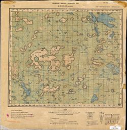
- Description:
- 1936
- Subject:
- Geographic Subject: Ozero Vadozero, Topical Subject: Soviet Union, and Topical Subject: Maps
- Publisher:
- Управление военных топографов РККА
- Language:
- Russian
- Identifier:
- VAC9619-002568
- Genre:
- Topographic Maps and Military Maps
- Geographic Location:
- Coordinates: 67, 31, 67.333, 32
- Related URL:
- Download GeoTIFF: https://drive.google.com/file/d/1tQnrCvTr4D-7FlG7pcuATUnFg3cTE22e/view?usp=sharing and Catalog URL: https://iucat.iu.edu/catalog/5020129
- Abstract:
- Modern area represented: Ozero Vadozero, Murmansk oblast, Russia
- Call Number:
- G7000 s100 .S7 sheet Q-36-27
- Caption:
- Не подлежит оглашению,Captured map
- City:
- Вад-озеро (Ozero Vadozero)
- Copyright Holder:
- No Copyright - United States
- Country:
- СССР (USSR)
- State/Province:
- Ленинградская область (Leningrad oblast), РСФСР (RSFSR), and Карельская АССР (Karelian Autonomous Soviet Socialist Republic)
- Physical Description:
- Scale: 1:100,000
- Persistent URL:
- http://purl.dlib.indiana.edu/iudl/images/VAC9619/VAC9619-002568
- Provenance:
- DMA Topographic Center, Army Map Service Library, OMAHA
-
- Description:
- 1936
- Subject:
- Topical Subject: Soviet Union, Geographic Subject: Kirovsk, and Topical Subject: Maps
- Publisher:
- Управление военных топографов РККА
- Language:
- Russian
- Identifier:
- VAC9619-002567
- Genre:
- Military Maps and Topographic Maps
- Geographic Location:
- Coordinates: 67.333, 33, 67.667, 34
- Related URL:
- Download GeoTIFF: https://drive.google.com/file/d/1a5BZ-SSuUSClBTj619MbPA7_Am8QeQpT/view?usp=sharing and Catalog URL: https://iucat.iu.edu/catalog/5020129
- Abstract:
- Modern area represented: Кировск (Kirovsk), Murmanskaya oblast, Russia
- Call Number:
- G7000 s100 .S7 sheet Q-36-19
- Caption:
- Не подлежит оглашению and Captured map
- City:
- Кировск (Kirovsk)
- Copyright Holder:
- No Copyright - United States
- Country:
- СССР (USSR)
- State/Province:
- РСФСР (RSFSR) and Ленинградская область (Leningrad oblast)
- Physical Description:
- Scale: 1:100,000
- Persistent URL:
- http://purl.dlib.indiana.edu/iudl/images/VAC9619/VAC9619-002567
- Provenance:
- DMA Topographic Center, Army Map Service Library, OMAHA
-
- Description:
- 1938
- Subject:
- Topical Subject: Soviet Union, Geographic Subject: Sumskiy Posad, and Topical Subject: Maps
- Publisher:
- Itä-Karjalan kartasto
- Language:
- Russian
- Identifier:
- VAC9619-002628
- Genre:
- Topographic Maps and Military Maps
- Geographic Location:
- Coordinates: 64, 35, 64.333, 35.5
- Related URL:
- Catalog URL: https://iucat.iu.edu/catalog/5020129 and Download GeoTIFF: https://drive.google.com/file/d/1os2-CTkeLt1ja44b0AJXS7uQmKjqEaOF/view?usp=sharing
- Abstract:
- Modern area represented: Sumskiy Posad, Republic of Karelia, Russia
- Call Number:
- G7000 s100 .S7 sheet Q-36-143
- City:
- Сумский Посад (Sumskiy Posad)
- Copyright Holder:
- No Copyright - United States
- Country:
- СССР (USSR)
- State/Province:
- РСФСР (RSFSR), Карельская АССР (Karelian Autonomous Soviet Socialist Republic), and Беломорский район (Belomorskiy district)
- Physical Description:
- Scale: 1:100,000
- Persistent URL:
- http://purl.dlib.indiana.edu/iudl/images/VAC9619/VAC9619-002628
- Provenance:
- DMA Topographic Center, Army Map Service Library, OMAHA, Geographic Names Branch, Atlasblatt
-
- Subject:
- Topical Subject: Maps, Geographic Subject: Kompakovo, and Topical Subject: Soviet Union
- Publisher:
- Itä-Karjalan kartasto
- Language:
- Russian
- Identifier:
- VAC9619-002627
- Genre:
- Military Maps and Topographic Maps
- Geographic Location:
- Coordinates: 64, 33, 64.333, 33.5
- Related URL:
- Catalog URL: https://iucat.iu.edu/catalog/5020129 and Download GeoTIFF: https://drive.google.com/file/d/1JfsOmHZ42nOsXDVN-rgwIAwDgAaX-C-w/view?usp=sharing
- Abstract:
- Modern area represented: Kompakovo, Republic of Karelia, Russia
- Call Number:
- G7000 s100 .S7 sheet Q-36-139
- City:
- Компаково (Kompakovo)
- Copyright Holder:
- No Copyright - United States
- Country:
- СССР (USSR)
- State/Province:
- Карельская АССР (Karelian Autonomous Soviet Socialist Republic) and РСФСР (RSFSR)
- Physical Description:
- Scale: 1:100,000
- Persistent URL:
- http://purl.dlib.indiana.edu/iudl/images/VAC9619/VAC9619-002627
- Provenance:
- DMA Topographic Center, Army Map Service Library, OMAHA
-
- Description:
- 1935
- Subject:
- Topical Subject: Soviet Union, Geographic Subject: Rugozero, and Topical Subject: Maps
- Publisher:
- Itä-Karjalan kartasto
- Language:
- Russian
- Identifier:
- VAC9619-002626
- Genre:
- Topographic Maps and Military Maps
- Geographic Location:
- Coordinates: 64, 32.5, 64.333, 33
- Related URL:
- Download GeoTIFF: https://drive.google.com/file/d/1sTlYiOKDyMOUd39W1edYgRFws5RTdTsm/view?usp=sharing and Catalog URL: https://iucat.iu.edu/catalog/5020129
- Abstract:
- Modern area represented: Rugozero, Republic of Karelia, Russia
- Call Number:
- G7000 s100 .S7 sheet Q-36-138
- City:
- Ругозеро (Rugozero)
- Copyright Holder:
- No Copyright - United States
- Country:
- СССР (USSR)
- State/Province:
- Карельская АССР (Karelian Autonomous Soviet Socialist Republic) and РСФСР (RSFSR)
- Physical Description:
- Scale: 1:100,000
- Persistent URL:
- http://purl.dlib.indiana.edu/iudl/images/VAC9619/VAC9619-002626
- Provenance:
- DMA Topographic Center, Army Map Service Library, OMAHA
-
- Description:
- 1936
- Subject:
- Topical Subject: Soviet Union, Geographic Subject: Andronova Gora, and Topical Subject: Maps
- Publisher:
- Itä-Karjalan kartasto
- Language:
- Russian
- Identifier:
- VAC9619-002625
- Genre:
- Military Maps and Topographic Maps
- Geographic Location:
- Coordinates: 64, 32, 64.333, 32.5
- Related URL:
- Catalog URL: https://iucat.iu.edu/catalog/5020129 and Download GeoTIFF: https://drive.google.com/file/d/11IyD7C--hjUZkrKlBr9L-3e0OGlrfYWJ/view?usp=sharing
- Abstract:
- Modern area represented: Andronova Gora, Republic of Karelia, Russia
- Call Number:
- G7000 s100 .S7 sheet Q-36-137
- City:
- Андронова Гора (Andronova Gora)
- Copyright Holder:
- No Copyright - United States
- Country:
- СССР (USSR)
- State/Province:
- РСФСР (RSFSR) and Карельская АССР (Karelian Autonomous Soviet Socialist Republic)
- Physical Description:
- Scale: 1:100,000
- Persistent URL:
- http://purl.dlib.indiana.edu/iudl/images/VAC9619/VAC9619-002625
- Provenance:
- DMA Topographic Center, Army Map Service Library, OMAHA
-
- Description:
- 1935
- Subject:
- Geographic Subject: Tikshozero, Topical Subject: Maps, and Topical Subject: Soviet Union
- Publisher:
- Itä-Karjalan kartasto
- Language:
- Russian
- Identifier:
- VAC9619-002624
- Genre:
- Topographic Maps and Military Maps
- Geographic Location:
- Coordinates: 64, 31.5, 64.333, 32
- Related URL:
- Download GeoTIFF: https://drive.google.com/file/d/1YVEnEbAP7MnVkA0HzjQDB8DbYBJ00Sr9/view?usp=sharing and Catalog URL: https://iucat.iu.edu/catalog/5020129
- Abstract:
- Modern area represented: Tikshozero, Republic of Karelia, Russia
- Call Number:
- G7000 s100 .S7 sheet Q-36-136
- City:
- Тикшозеро (Tikshozero)
- Copyright Holder:
- No Copyright - United States
- Country:
- СССР (USSR)
- State/Province:
- РСФСР (RSFSR) and Карельская АССР (Karelian Autonomous Soviet Socialist Republic)
- Physical Description:
- Scale: 1:100,000
- Persistent URL:
- http://purl.dlib.indiana.edu/iudl/images/VAC9619/VAC9619-002624
- Provenance:
- DMA Topographic Center, Army Map Service Library, OMAHA
-
- Description:
- 1935
- Subject:
- Topical Subject: Maps, Geographic Subject: Lekhta, and Topical Subject: Soviet Union
- Publisher:
- Itä-Karjalan kartasto
- Language:
- Russian
- Identifier:
- VAC9619-002622
- Genre:
- Topographic Maps and Military Maps
- Geographic Location:
- Coordinates: 64.333, 33.5, 64.667, 34
- Related URL:
- Catalog URL: https://iucat.iu.edu/catalog/5020129 and Download GeoTIFF: https://drive.google.com/file/d/1H-zusK4nCqMdi2acHPKHwvhmkyscC0kg/view?usp=sharing
- Abstract:
- Modern area represented: Lekhta, Republic of Karelia, Russia
- Call Number:
- G7000 s100 .S7 sheet Q-36-128
- City:
- Лехта (Lekhta)
- Copyright Holder:
- No Copyright - United States
- Country:
- СССР (USSR)
- State/Province:
- Карельская АССР (Karelian Autonomous Soviet Socialist Republic) and РСФСР (RSFSR)
- Physical Description:
- Scale: 1:100,000
- Persistent URL:
- http://purl.dlib.indiana.edu/iudl/images/VAC9619/VAC9619-002622
- Provenance:
- DMA Topographic Center, Army Map Service Library, OMAHA
-
- Description:
- 1935
- Subject:
- Topical Subject: Maps, Topical Subject: Soviet Union, and Geographic Subject: Tunguda
- Publisher:
- Itä-Karjalan kartasto
- Language:
- Russian
- Identifier:
- VAC9619-002621
- Genre:
- Topographic Maps and Military Maps
- Geographic Location:
- Coordinates: 64.3333, 33.0, 64.6667, 33.5
- Related URL:
- Download GeoTIFF: https://drive.google.com/file/d/1zz7HV-w2OGTqvB7xYTkMbNeFa-3Iuucy/view?usp=sharing and Catalog URL: https://iucat.iu.edu/catalog/5020129
- Abstract:
- Modern area represented: Tunguda, Republic of Karelia, Russia
- Call Number:
- G7000 s100 .S7 sheet Q-36-127
- City:
- Тунгуда (Tunguda)
- Copyright Holder:
- No Copyright - United States
- Country:
- СССР (USSR)
- State/Province:
- Карельская АССР (Karelian Autonomous Soviet Socialist Republic) and РСФСР (RSFSR)
- Physical Description:
- Scale: 1:100,000
- Persistent URL:
- http://purl.dlib.indiana.edu/iudl/images/VAC9619/VAC9619-002621
- Provenance:
- DMA Topographic Center, Army Map Service Library, OMAHA
-
- Description:
- 1935
- Subject:
- Topical Subject: Maps, Geographic Subject: Piz’maguba, and Topical Subject: Soviet Union
- Publisher:
- Itä-Karjalan kartasto
- Language:
- Russian
- Identifier:
- VAC9619-002620
- Genre:
- Topographic Maps and Military Maps
- Geographic Location:
- Coordinates: 64.333, 31.5, 64.667, 32
- Related URL:
- Catalog URL: https://iucat.iu.edu/catalog/5020129 and Download GeoTIFF: https://drive.google.com/file/d/1EAOj2vLqR8u_JsCQTpqSGsUtFP3xx8Ih/view?usp=sharing
- Abstract:
- Modern are represented: Пизьмагуба (Piz’maguba), Republic of Karelia, Russia.
- Call Number:
- G7000 s100 .S7 sheet Q-36-124
- City:
- Пизьмогуба (Piz’moguba)
- Copyright Holder:
- No Copyright - United States
- Country:
- СССР (USSR)
- State/Province:
- РСФСР (RSFSR) and Карельская АССР (Karelian Autonomous Soviet Socialist Republic)
- Physical Description:
- Scale: 1:100,000
- Persistent URL:
- http://purl.dlib.indiana.edu/iudl/images/VAC9619/VAC9619-002620
- Provenance:
- DMA Topographic Center, Army Map Service Library, OMAHA
-
- Description:
- 1935
- Subject:
- Geographic Subject: Babya Guba, Topical Subject: Soviet Union, and Topical Subject: Maps
- Publisher:
- Itä-Karjalan kartasto
- Language:
- Russian
- Identifier:
- VAC9619-002619
- Genre:
- Military Maps and Topographic Maps
- Geographic Location:
- Coordinates: 64.333, 30, 64.667, 30.5
- Related URL:
- Download GeoTIFF: https://drive.google.com/file/d/1AA7FyE6sffkeuxva0pcxVZ6e1E7qN4hq/view?usp=sharing and Catalog URL: https://iucat.iu.edu/catalog/5020129
- Abstract:
- Modern area represented: Babya Guba, Republic of Karelia, Russia
- Call Number:
- G7000 s100 .S7 sheet Q-36-121
- City:
- Бабья Губа (Babya Guba)
- Copyright Holder:
- No Copyright - United States
- Country:
- СССР (USSR)
- State/Province:
- РСФСР (RSFSR) and Карельская АССР (Karelian Autonomous Soviet Socialist Republic)
- Physical Description:
- Scale: 1:100,000
- Persistent URL:
- http://purl.dlib.indiana.edu/iudl/images/VAC9619/VAC9619-002619
- Provenance:
- DMA Topographic Center, Army Map Service Library, OMAHA
-
- Description:
- 1935
- Subject:
- Topical Subject: Maps, Topical Subject: Soviet Union, and Geographic Subject: Segezha
- Publisher:
- Управление военных топографов РККА
- Language:
- Russian
- Identifier:
- VAC9619-002476
- Genre:
- Topographic Maps and Military Maps
- Geographic Location:
- Coordinates: 63.666, 34, 64, 34.5
- Related URL:
- Catalog URL: https://iucat.iu.edu/catalog/5020129 and Download GeoTIFF: https://drive.google.com/file/d/1L96fyQCs8VSVAxWfgcbtihnyUfmv5iKQ/view?usp=sharing
- Abstract:
- Modern area represented: Segezha, Republic of Karelia, Russia
- Call Number:
- G7000 s100 .S7 sheet P-36-9
- City:
- Сегежа (Segezha)
- Copyright Holder:
- No Copyright - United States
- Country:
- СССР (USSR)
- State/Province:
- Карельская АССР (Karelian Autonomous Soviet Socialist Republic) and РСФСР (RSFSR)
- Physical Description:
- Scale: 1:100,000
- Persistent URL:
- http://purl.dlib.indiana.edu/iudl/images/VAC9619/VAC9619-002476
- Provenance:
- DMA Topographic Center, Army Map Service Library, OMAHA
-
- Description:
- 1933
- Subject:
- Geographic Subject: Pulcheyla, Topical Subject: Soviet Union, and Topical Subject: Maps
- Language:
- Russian
- Date Created:
- 1933
- Identifier:
- VAC9619-000069
- Genre:
- Military Maps and Topographic Maps
- Geographic Location:
- Coordinates: 61.333, 32.137, 61.5, 32.5
- Related URL:
- Catalog URL: http://iucat.iu.edu/catalog/5020131 and Download GeoTIFF: https://drive.google.com/open?id=1sntEOE0udkFPFBOTe018EIPqgTx8xKkm
- Abstract:
- Modern area represented: Pulcheyla, Republic of Karelia, Russia
- Call Number:
- G7000 s50 .S68 sheet P-36-89-C
- City:
- Пульчейло (Pulcheylo)
- Copyright Holder:
- No Copyright - United States
- Country:
- СССР (USSR)
- State/Province:
- Карельская АССР (Karelian Autonomous Soviet Socialist Republic) and РСФСР (RSFSR)
- Physical Description:
- Scale: 1:50,000
- Persistent URL:
- http://purl.dlib.indiana.edu/iudl/images/VAC9619/VAC9619-000069
- Provenance:
- DMA Topographic Center, Army Map Service Library, OMAHA, Library of Congress Geography & Map Division
-
- Description:
- 1934
- Subject:
- Topical Subject: Soviet Union, Topical Subject: Maps, and Geographic Subject: Gilkozha
- Language:
- Russian
- Identifier:
- VAC9619-000067
- Genre:
- Topographic Maps and Military Maps
- Geographic Location:
- Coordinates: 61.5, 32, 61.667, 32.25
- Related URL:
- Download GeoTIFF: https://drive.google.com/open?id=1LMufJbthe1GpqewHgRmjdB4VosK-WtJK and Catalog URL: http://iucat.iu.edu/catalog/5020131
- Abstract:
- Modern area represented: Gilkozha, Republic of Karelia, Russia
- Call Number:
- G7000 s50 .S68 sheet P-36-89-A
- City:
- Ювенсу (Yuvensu)
- Copyright Holder:
- No Copyright - United States
- Country:
- СССР (USSR)
- State/Province:
- РСФСР (RSFSR) and Карельская АССР (Karelian Autonomous Soviet Socialist Republic)
- Physical Description:
- Scale: 1:50,000
- Persistent URL:
- http://purl.dlib.indiana.edu/iudl/images/VAC9619/VAC9619-000067
- Provenance:
- M. I. Map Library, G000-30, GS, RA, Atlasblatt
-
- Description:
- 1935
- Subject:
- Topical Subject: Maps, Topical Subject: Soviet Union, and Geographic Subject: Petrozavodsk
- Publisher:
- Управление военных топографов РККА
- Language:
- Russian
- Identifier:
- VAC9619-002530
- Genre:
- Military Maps and Topographic Maps
- Geographic Location:
- Coordinates: 61.667, 34, 62, 34.5
- Related URL:
- Download GeoTIFF: https://drive.google.com/file/d/16-upx4HzlzszYevE8qmMvmndKlOe0ILK/view?usp=sharing and Catalog URL: https://iucat.iu.edu/catalog/5020129
- Abstract:
- Modern area represented: Petrozavodsk, Republic of Karelia, Russia
- Call Number:
- G7000 s100 .S7 sheet P-36-81
- Caption:
- Не подлежит оглашению,Captured map
- City:
- Петрозаводск (Petrozavodsk)
- Copyright Holder:
- No Copyright - United States
- Country:
- СССР (USSR)
- State/Province:
- РСФСР (RSFSR) and Карельская АССР (Karelian Autonomous Soviet Socialist Republic)
- Physical Description:
- Scale: 1:100,000
- Persistent URL:
- http://purl.dlib.indiana.edu/iudl/images/VAC9619/VAC9619-002530
- Provenance:
- DMA Topographic Center, Army Map Service Library, OMAHA, Auswärtiges Amt. Geographischer Dienst
-
- Description:
- 1934
- Subject:
- Topical Subject: Soviet Union, Topical Subject: Maps, and Geographic Subject: Essoyla
- Language:
- Russian
- Identifier:
- VAC9619-002962
- Genre:
- Topographic Maps and Military Maps
- Geographic Location:
- Coordinates: 61.833, 33, 62, 33.25
- Related URL:
- Catalog URL: http://iucat.iu.edu/catalog/5020131 and Download GeoTIFF: https://drive.google.com/file/d/1xgiGOQ7LQQ18q-T-0SBAdftFvx7OS3_i/view?usp=sharing
- Abstract:
- Modern area represented: Essoyla, Republic of Karelia, Russia
- Call Number:
- GM G7000 s50 .S68 sheet P-36-79-A
- City:
- Эссойла (Essoyla)
- Copyright Holder:
- No Copyright - United States
- Country:
- СССР (USSR)
- State/Province:
- РСФСР (RSFSR) and Карельская АССР (Karelian Autonomous Soviet Socialist Republic)
- Physical Description:
- Scale: 1:50,000
- Persistent URL:
- http://purl.dlib.indiana.edu/iudl/images/VAC9619/VAC9619-002962
- Provenance:
- DMA Topographic Center, Army Map Service Library, OMAHA, Library of Congress Geography & Map Division
-

- Description:
- 1934
- Subject:
- Geographic Subject: Veshkilitsy, Topical Subject: Soviet Union, and Topical Subject: Maps
- Language:
- Russian
- Identifier:
- VAC9619-002961
- Genre:
- Military Maps and Topographic Maps
- Geographic Location:
- Coordinates: 61.833, 32.75, 62, 33
- Related URL:
- Download GeoTIFF: https://drive.google.com/file/d/1RZIivpkGkbwqMW1lH2LkW7a-Bc7_FN8v/view?usp=sharing and Catalog URL: http://iucat.iu.edu/catalog/5020131
- Abstract:
- Modern area represented: Вешкелица (Veshkelitsa), Republic of Karelia, Russia
- Call Number:
- GM G7000 s50 .S68 sheet P-36-78-B
- City:
- Вешкелицы (Veshkilitsy)
- Copyright Holder:
- No Copyright - United States
- Country:
- СССР (USSR)
- State/Province:
- Карельская АССР (Karelian Autonomous Soviet Socialist Republic) and РСФСР (RSFSR)
- Physical Description:
- Scale: 1:50,000
- Persistent URL:
- http://purl.dlib.indiana.edu/iudl/images/VAC9619/VAC9619-002961
- Provenance:
- DMA Topographic Center, Army Map Service Library, OMAHA, Library of Congress Geography & Map Division
-
- Description:
- 1934
- Subject:
- Topical Subject: Maps, Topical Subject: Soviet Union, and Geographic Subject: Posad
- Language:
- Russian
- Identifier:
- VAC9619-002960
- Genre:
- Military Maps and Topographic Maps
- Geographic Location:
- Coordinates: 61.833, 32.5, 62, 32.75
- Related URL:
- Download GeoTIFF: https://drive.google.com/file/d/1NAZaL33KDwAhDWiBjWEBe_NtGsIJw_7C/view?usp=sharing and Catalog URL: http://iucat.iu.edu/catalog/5020131
- Abstract:
- Modern area represented: Posad, Russia
- Call Number:
- GM G7000 s50 .S68 sheet P-36-78-A
- City:
- Посад (Posad)
- Copyright Holder:
- No Copyright - United States
- Country:
- СССР (USSR)
- State/Province:
- Карельская АССР (Karelian Autonomous Soviet Socialist Republic) and РСФСР (RSFSR)
- Physical Description:
- Scale: 1:50,000
- Persistent URL:
- http://purl.dlib.indiana.edu/iudl/images/VAC9619/VAC9619-002960
- Provenance:
- DMA Topographic Center, Army Map Service Library, OMAHA, Library of Congress Geography & Map Division
-
- Subject:
- Topical Subject: Maps and Topical Subject: Soviet Union
- Publisher:
- Генеральный штаб РККА
- Language:
- Russian
- Identifier:
- VAC9619-002527
- Genre:
- Topographic Maps and Military Maps
- Geographic Location:
- Coordinates: 61.667, 32.5, 62, 33
- Related URL:
- Catalog URL: https://iucat.iu.edu/catalog/5020129 and Download GeoTIFF: https://drive.google.com/file/d/1e6n54jJFl0OY_ZS_KceUJ7GJTsBLnt2b/view?usp=sharing
- Abstract:
- Modern area represented: Вешкелица (Veshkelitsa), Republic of Karelia, Russia
- Call Number:
- G7000 s100 .S7 sheet P-36-78
- Caption:
- Не подлежит оглашению
- City:
- Вешкелицы (Veshkilitsy)
- Copyright Holder:
- No Copyright - United States
- Country:
- СССР (USSR) and Финляндия (Finland)
- State/Province:
- Карельская АССР (Karelian Autonomous Soviet Socialist Republic) and РСФСР (RSFSR)
- Physical Description:
- Scale: 1:100,000
- Persistent URL:
- http://purl.dlib.indiana.edu/iudl/images/VAC9619/VAC9619-002527
- Provenance:
- DMA Topographic Center, Army Map Service Library, OMAHA, Auswärtiges Amt. Geographischer Dienst
-
- Subject:
- Topical Subject: Maps, Geographic Subject: Pazhilo, and Topical Subject: Soviet Union
- Language:
- Russian
- Identifier:
- VAC9619-000066
- Genre:
- Topographic Maps and Military Maps
- Geographic Location:
- Coordinates: 61.667, 32.25, 61.833, 32.5
- Related URL:
- Download GeoTIFF: https://drive.google.com/open?id=11OfMCa_E44TFwpGOdRsRl1d9twyoNcZQ and Catalog URL: http://iucat.iu.edu/catalog/5020131
- Abstract:
- Modern area represented: Pazhilo, Republic of Karelia, Russia
- Call Number:
- G7000 s50 .S68 sheet P-36-77-G
- City:
- Пажило (Pazhilo)
- Copyright Holder:
- No Copyright - United States
- Country:
- СССР (USSR)
- State/Province:
- Карельская АССР (Karelian Autonomous Soviet Socialist Republic) and РСФСР (RSFSR)
- Physical Description:
- Scale: 1:50,000
- Persistent URL:
- http://purl.dlib.indiana.edu/iudl/images/VAC9619/VAC9619-000066
- Provenance:
- DMA Topographic Center, Army Map Service Library, Library of Congress Geography & Map Division
-
- Description:
- 1934
- Subject:
- Topical Subject: Soviet Union, Topical Subject: Maps, and Geographic Subject: Nishkozero
- Language:
- Russian
- Identifier:
- VAC9619-000064
- Genre:
- Military Maps and Topographic Maps
- Geographic Location:
- Coordinates: 61.833, 32.128, 62, 32.5
- Related URL:
- Catalog URL: http://iucat.iu.edu/catalog/5020131 and Download GeoTIFF: https://drive.google.com/open?id=1jFcONOAbCc57tOkEsGOvp2cxlZFHhi7R
- Abstract:
- Modern area represented: Nishkozero, Republic of Karelia, Russia
- Call Number:
- G7000 s50 .S68 sheet P-36-77-A
- City:
- Нишкозеро (Nishkozero)
- Copyright Holder:
- No Copyright - United States
- Country:
- СССР (USSR)
- State/Province:
- Карельская АССР (Karelian Autonomous Soviet Socialist Republic) and РСФСР (RSFSR)
- Physical Description:
- Scale: 1:50,000
- Persistent URL:
- http://purl.dlib.indiana.edu/iudl/images/VAC9619/VAC9619-000064
- Provenance:
- DMA Topographic Center, Army Map Service Library, Library of Congress Geography & Map Division
-
- Description:
- 1934
- Subject:
- Topical Subject: Soviet Union, Geographic Subject: Kolatselga, and Topical Subject: Maps
- Language:
- Russian
- Identifier:
- VAC9619-000065
- Genre:
- Topographic Maps and Military Maps
- Geographic Location:
- Coordinates: 61.667, 32, 61.833, 32.25
- Related URL:
- Catalog URL: http://iucat.iu.edu/catalog/5020131 and Download GeoTIFF: https://drive.google.com/open?id=1JH8SGoiabG5jitcDvA-ayFvLzptmn4nb
- Abstract:
- Modern area represented: Kolatselga, Republic of Karelia, Russia
- Call Number:
- G7000 s50 .S68 sheet P-36-77-B
- City:
- Колат-Сельга (Kolat-Selga)
- Copyright Holder:
- No Copyright - United States
- Country:
- СССР (USSR)
- State/Province:
- Карельская АССР (Karelian Autonomous Soviet Socialist Republic) and РСФСР (RSFSR)
- Physical Description:
- Scale: 1:50,000
- Persistent URL:
- http://purl.dlib.indiana.edu/iudl/images/VAC9619/VAC9619-000065
- Provenance:
- DMA Topographic Center, Army Map Service Library, OMAHA, Library of Congress Geography & Map Division
-
- Subject:
- Topical Subject: Soviet Union, Topical Subject: Maps, and Geographic Subject: Kolatsel'ga
- Publisher:
- Генеральный штаб РККА
- Language:
- Russian
- Identifier:
- VAC9619-002526
- Genre:
- Military Maps and Topographic Maps
- Geographic Location:
- Coordinates: 61.6667, 32.0, 62.0, 32.5
- Related URL:
- Catalog URL: https://iucat.iu.edu/catalog/5020129 and Download GeoTIFF: https://drive.google.com/file/d/1CmmK9u9JF9UZf2DAAFi_NIna7fR8EQw7/view?usp=sharing
- Abstract:
- Modern area represented: Колатсельга (Kolatsel'ga), Republic of Karelia, Russia
- Call Number:
- G7000 s100 .S7 sheet P-36-77
- Caption:
- Не подлежит оглашению
- City:
- Колат-Сельга
- Copyright Holder:
- No Copyright - United States
- Country:
- Финляндия (Finland) and СССР (USSR)
- State/Province:
- Карельская АССР (Karelian Autonomous Soviet Socialist Republic) and РСФСР (RSFSR)
- Physical Description:
- Scale: 1:100,000
- Persistent URL:
- http://purl.dlib.indiana.edu/iudl/images/VAC9619/VAC9619-002526
- Provenance:
- DMA Topographic Center, Army Map Service Library, OMAHA
-
- Description:
- 1938
- Subject:
- Topical Subject: Soviet Union, Topical Subject: Maps, and Geographic Subject: Tipinitsy
- Publisher:
- Itä-Karjalan kartasto
- Language:
- Russian
- Date Created:
- 1941
- Identifier:
- VAC9619-002521
- Genre:
- Topographic Maps and Military Maps
- Geographic Location:
- Coordinates: 62, 35, 62.333, 35.5
- Related URL:
- Download GeoTIFF: https://drive.google.com/file/d/16n70OB4W7s3AZ038yYTIjX6WxSal2LSA/view?usp=sharing and Catalog URL: https://iucat.iu.edu/catalog/5020129
- Abstract:
- Modern area represented: Типиницы (Tipinitsy), Медвежьегорский район (Medvezh'yegorskiy District), Republic of Karelia, Russia
- Call Number:
- G7000 s100 .S7 sheet P-36-71
- Copyright Holder:
- No Copyright - United States
- Country:
- СССР (USSR)
- State/Province:
- Заонежский район (Zaonezhsky district), РСФСР (RSFSR), and Карельская АССР (Karelian Autonomous Soviet Socialist Republic)
- Physical Description:
- Scale: 1:100,000
- Persistent URL:
- http://purl.dlib.indiana.edu/iudl/images/VAC9619/VAC9619-002521
- Provenance:
- DMA Topographic Center, Army Map Service Library, OMAHA
-
- Description:
- 1935
- Subject:
- Topical Subject: Soviet Union, Geographic Subject: Ondozero, and Topical Subject: Maps
- Publisher:
- Itä-Karjalan kartasto
- Language:
- Russian
- Identifier:
- VAC9619-002474
- Genre:
- Topographic Maps and Military Maps
- Geographic Location:
- Coordinates: 63.667, 33, 64, 33.5
- Related URL:
- Download GeoTIFF: https://drive.google.com/file/d/1G_kLCaKmFqHbXcPnx733qtOiPyZ4YNbr/view?usp=sharing and Catalog URL: https://iucat.iu.edu/catalog/5020129
- Abstract:
- Modern area represented: Ondozero, Republic of Karelia, Russia
- Call Number:
- G7000 s100 .S7 sheet P-36-7
- City:
- Ондозеро (Ondozero)
- Copyright Holder:
- No Copyright - United States
- Country:
- СССР (USSR)
- State/Province:
- Карельская АССР (Karelian Autonomous Soviet Socialist Republic) and РСФСР (RSFSR)
- Physical Description:
- Scale: 1:100,000
- Persistent URL:
- http://purl.dlib.indiana.edu/iudl/images/VAC9619/VAC9619-002474
- Provenance:
- DMA Topographic Center, Army Map Service Library, OMAHA
-
- Description:
- 1934
- Subject:
- Geographic Subject: Vokhtozero, Topical Subject: Maps, and Topical Subject: Soviet Union
- Publisher:
- Управление военных топографов РККА
- Language:
- Russian
- Identifier:
- VAC9619-002519
- Genre:
- Topographic Maps and Military Maps
- Geographic Location:
- Coordinates: 62.0, 33.0, 62.3333, 33.5
- Related URL:
- Catalog URL: https://iucat.iu.edu/catalog/5020129 and Download GeoTIFF: https://drive.google.com/file/d/1g1FIhJz8s5StgUDkcFnnYndtPiF1hFXd/view?usp=sharing
- Abstract:
- Modern area represented: Vokhtozero, Republic of Karelia, Russia
- Call Number:
- G7000 s100 .S7 sheet P-36-67
- Caption:
- Captured map
- City:
- Вохтозеро (Vokhtozero)
- Copyright Holder:
- No Copyright - United States
- Country:
- СССР (USSR)
- State/Province:
- РСФСР (RSFSR) and Карельская АССР (Karelian Autonomous Soviet Socialist Republic)
- Physical Description:
- Scale: 1:100,000
- Persistent URL:
- http://purl.dlib.indiana.edu/iudl/images/VAC9619/VAC9619-002519
- Provenance:
- DMA Topographic Center, Army Map Service Library, OMAHA
-
- Subject:
- Geographic Subject: Kangozero, Topical Subject: Maps, and Topical Subject: Soviet Union
- Publisher:
- Itä-Karjalan kartasto
- Language:
- Russian
- Identifier:
- VAC9619-002518
- Genre:
- Military Maps and Topographic Maps
- Geographic Location:
- Coordinates: 62.0, 32.5, 62.3333, 33.0
- Related URL:
- Download GeoTIFF: https://drive.google.com/file/d/1yjJRPgRm9v9oXIDb-wiXsRo4Jipzyqhf/view?usp=sharing and Catalog URL: https://iucat.iu.edu/catalog/5020129
- Abstract:
- Modern area represented: Kangozero, Republic of Karelia, Russia
- Call Number:
- G7000 s100 .S7 sheet P-36-66
- City:
- Кангозеро (Kangozero)
- Copyright Holder:
- No Copyright - United States
- Country:
- СССР (USSR) and Финляндия (Finland)
- State/Province:
- Карельская АССР (Karelian Autonomous Soviet Socialist Republic) and РСФСР (RSFSR)
- Physical Description:
- Scale: 1:100,000
- Persistent URL:
- http://purl.dlib.indiana.edu/iudl/images/VAC9619/VAC9619-002518
- Provenance:
- DMA Topographic Center, Army Map Service Library, OMAHA
-
- Description:
- 1935
- Subject:
- Topical Subject: Maps, Topical Subject: Soviet Union, and Geographic Subject: Yevzhozero
- Publisher:
- Itä-Karjalan kartasto
- Language:
- Russian
- Identifier:
- VAC9619-002473
- Genre:
- Military Maps and Topographic Maps
- Geographic Location:
- Coordinates: 63.667, 32.5, 64, 33
- Related URL:
- Download GeoTIFF: https://drive.google.com/file/d/1HE4XTpQ9Cmd_SgHBh0J3YdxC4mBmhxBx/view?usp=sharing and Catalog URL: https://iucat.iu.edu/catalog/5020129
- Abstract:
- Modern area represented: Yevzhozero, Republic of Karelia, Russia
- Call Number:
- G7000 s100 .S7 sheet P-36-6
- Caption:
- Captured map
- City:
- Евжозеро (Yevzhozero)
- Copyright Holder:
- No Copyright - United States
- Country:
- СССР (USSR)
- State/Province:
- РСФСР (RSFSR) and Карельская АССР (Karelian Autonomous Soviet Socialist Republic)
- Physical Description:
- Scale: 1:100,000
- Persistent URL:
- http://purl.dlib.indiana.edu/iudl/images/VAC9619/VAC9619-002473
- Provenance:
- DMA Topographic Center, Army Map Service Library, OMAHA
-
- Description:
- 1935
- Subject:
- Topical Subject: Maps, Geographic Subject: Kyappeselga, and Topical Subject: Soviet Union
- Publisher:
- Itä-Karjalan kartasto
- Language:
- Russian
- Identifier:
- VAC9619-002511
- Genre:
- Topographic Maps and Military Maps
- Geographic Location:
- Coordinates: 62.333, 34, 62.667, 34.5
- Related URL:
- Catalog URL: https://iucat.iu.edu/catalog/5020129 and Download GeoTIFF: https://drive.google.com/file/d/1EniezzlGFitVqw083Ci6jyJfqcmK7Teu/view?usp=sharing
- Abstract:
- Modern area represented: Kyappeselga, Republic of Karelia, Russia
- Call Number:
- G7000 s100 .S7 sheet P-36-57
- Caption:
- Captured map
- City:
- Кяппесельга (Kyappeselga)
- Copyright Holder:
- No Copyright - United States
- Country:
- СССР (USSR)
- State/Province:
- РСФСР (RSFSR) and Карельская АССР (Karelian Autonomous Soviet Socialist Republic)
- Physical Description:
- Scale: 1:100,000
- Persistent URL:
- http://purl.dlib.indiana.edu/iudl/images/VAC9619/VAC9619-002511
- Provenance:
- DMA Topographic Center, Army Map Service Library, OMAHA
-
- Description:
- 1934
- Subject:
- Topical Subject: Soviet Union, Geographic Subject: Tivdiya, and Topical Subject: Maps
- Publisher:
- Управление военных топографов РККА
- Language:
- Russian
- Identifier:
- VAC9619-002510
- Genre:
- Topographic Maps and Military Maps
- Geographic Location:
- Coordinates: 62.333, 33.5, 62.667, 34
- Related URL:
- Catalog URL: https://iucat.iu.edu/catalog/5020129 and Download GeoTIFF: https://drive.google.com/file/d/1arD4JoxZwzAxe4AfL8z3AOOyzBAvMuZU/view?usp=sharing
- Abstract:
- Modern area represented: Tivdiya, Republic of Karelia, Russia
- Call Number:
- G7000 s100 .S7 sheet P-36-56
- Caption:
- Не подлежит оглашению
- City:
- Тивдия (Тivdiya)
- Copyright Holder:
- No Copyright - United States
- Country:
- СССР (USSR)
- State/Province:
- РСФСР (RSFSR) and Карельская АССР (Karelian Autonomous Soviet Socialist Republic)
- Physical Description:
- Scale: 1:100,000
- Persistent URL:
- http://purl.dlib.indiana.edu/iudl/images/VAC9619/VAC9619-002510
- Provenance:
- DMA Topographic Center, Army Map Service Library, OMAHA
-
- Description:
- 1934
- Subject:
- Topical Subject: Maps, Geographic Subject: Lindozero, and Topical Subject: Soviet Union
- Publisher:
- Управление военных топографов РККА
- Language:
- Russian
- Identifier:
- VAC9619-002509
- Genre:
- Topographic Maps and Military Maps
- Geographic Location:
- Coordinates: 62.333, 33, 62.667, 33.5
- Related URL:
- Download GeoTIFF: https://drive.google.com/file/d/1eTGCgxq0lXDE-S9i4zl9GmUhJjM81Jo-/view?usp=sharing and Catalog URL: https://iucat.iu.edu/catalog/5020129
- Abstract:
- Modern area represented: Lindozero, Republic of Karelia, Russia
- Call Number:
- G7000 s100 .S7 sheet P-36-55
- Caption:
- Captured map
- City:
- Линдозеро (Lindozero)
- Copyright Holder:
- No Copyright - United States
- Country:
- СССР (USSR)
- State/Province:
- РСФСР (RSFSR) and Карельская АССР (Karelian Autonomous Soviet Socialist Republic)
- Physical Description:
- Scale: 1:100,000
- Persistent URL:
- http://purl.dlib.indiana.edu/iudl/images/VAC9619/VAC9619-002509
- Provenance:
- DMA Topographic Center, Army Map Service Library, OMAHA, Auswärtiges Amt. Geographischer Dienst
-
- Subject:
- Geographic Subject: Vegarus, Topical Subject: Maps, and Topical Subject: Soviet Union
- Publisher:
- Генеральный штаб РККА
- Language:
- Russian
- Identifier:
- VAC9619-002508
- Genre:
- Military Maps and Topographic Maps
- Geographic Location:
- Coordinates: 62.333, 32, 62.667, 32.5
- Related URL:
- Download GeoTIFF: https://drive.google.com/file/d/10U3_iR_PUCb7zF_yRip-TGm39Picu_7O/view?usp=sharing and Catalog URL: https://iucat.iu.edu/catalog/5020129
- Abstract:
- Modern area represented: Vegarus, Republic of Karelia, Russia
- Call Number:
- G7000 s100 .S7 sheet P-36-53
- Caption:
- Captured map
- City:
- Вегарус (Vegarus)
- Copyright Holder:
- No Copyright - United States
- Country:
- Финляндия (Finland) and СССР (USSR)
- State/Province:
- РСФСР (RSFSR) and Карельская АССР (Karelian Autonomous Soviet Socialist Republic)
- Physical Description:
- Scale: 1:100,000
- Persistent URL:
- http://purl.dlib.indiana.edu/iudl/images/VAC9619/VAC9619-002508
- Provenance:
- DMA Topographic Center, Army Map Service Library, OMAHA
-
- Description:
- 1935
- Subject:
- Geographic Subject: Poselok Pyatdesyat Pervyy Kvartal, Topical Subject: Soviet Union, and Topical Subject: Maps
- Publisher:
- Itä-Karjalan kartasto
- Language:
- Russian
- Identifier:
- VAC9619-002472
- Genre:
- Military Maps and Topographic Maps
- Geographic Location:
- Coordinates: 63.667, 32, 64, 32.5
- Related URL:
- Catalog URL: https://iucat.iu.edu/catalog/5020129 and Download GeoTIFF: https://drive.google.com/file/d/1RLczKX6qCnXOOVxLAdMW-75_kmqLsKKv/view?usp=sharing
- Abstract:
- Modern area represented: Poselok Pyatdesyat Pervyy Kvartal, Republic of Karelia, Russia
- Call Number:
- G7000 s100 .S7 sheet P-36-5
- City:
- Посёлок Пятьдесят Первый Квартал (Poselok Pyatdesyat Pervyy Kvartal)
- Copyright Holder:
- No Copyright - United States
- Country:
- СССР (USSR)
- State/Province:
- Карельская АССР (Karelian Autonomous Soviet Socialist Republic) and РСФСР (RSFSR)
- Physical Description:
- Scale: 1:100,000
- Persistent URL:
- http://purl.dlib.indiana.edu/iudl/images/VAC9619/VAC9619-002472
- Provenance:
- DMA Topographic Center, Army Map Service Library, OMAHA
-
- Description:
- 1937
- Subject:
- Topical Subject: Maps, Geographic Subject: Tikhvin Bor, and Topical Subject: Soviet Union
- Publisher:
- Itä-Karjalan kartasto
- Language:
- Russian
- Identifier:
- VAC9619-002502
- Genre:
- Military Maps and Topographic Maps
- Geographic Location:
- Coordinates: 62.667, 35.5, 63, 36
- Related URL:
- Catalog URL: https://iucat.iu.edu/catalog/5020129 and Download GeoTIFF: https://drive.google.com/file/d/1GSWJwpJmDDQ0oMSBw0ewiqGeiE5AYCMp/view?usp=sharing
- Abstract:
- Modern area represented: Tikhvin Bor, Republic of Karelia, Russia
- Call Number:
- G7000 s100 .S7 sheet P-36-48
- City:
- Тихвин Бор (Tikhvin Bor)
- Copyright Holder:
- No Copyright - United States
- Country:
- СССР (USSR)
- State/Province:
- РСФСР (RSFSR), Карельская АССР (Karelian Autonomous Soviet Socialist Republic), and Медвежьегорский район (Medvezhyegorsk district)
- Physical Description:
- Scale: 1:100,000
- Persistent URL:
- http://purl.dlib.indiana.edu/iudl/images/VAC9619/VAC9619-002502
- Provenance:
- DMA Topographic Center, Army Map Service Library, OMAHA
-
- Description:
- 1938
- Subject:
- Topical Subject: Maps, Geographic Subject: Shoyvany, and Topical Subject: Soviet Union
- Publisher:
- Itä-Karjalan kartasto
- Language:
- Russian
- Identifier:
- VAC9619-002501
- Genre:
- Topographic Maps and Military Maps
- Geographic Location:
- Coordinates: 62.667, 35, 63, 35.5
- Related URL:
- Catalog URL: https://iucat.iu.edu/catalog/5020129 and Download GeoTIFF: https://drive.google.com/file/d/1ljwJ_IlQ2_SjFi4dxgBZn_8y6wDU7smH/view?usp=sharing
- Abstract:
- Modern area represented: Шойваны (Shoyvany), Медвежьегорский район (Medvezh’yegorskiy District), Republic of Karelia, Russia
- Call Number:
- G7000 s100 .S7 sheet P-36-47
- City:
- Шойваны (Shoyvany)
- Copyright Holder:
- No Copyright - United States
- Country:
- СССР (USSR)
- State/Province:
- Медвежьегорский район (Medvezhyegorsk district), Карельская АССР (Karelian Autonomous Soviet Socialist Republic), and РСФСР (RSFSR)
- Physical Description:
- Scale: 1:100,000
- Persistent URL:
- http://purl.dlib.indiana.edu/iudl/images/VAC9619/VAC9619-002501
- Provenance:
- DMA Topographic Center, Army Map Service Library, OMAHA
-
- Description:
- 1935
- Subject:
- Topical Subject: Soviet Union, Geographic Subject: Medvezh'yegorsk, and Topical Subject: Maps
- Publisher:
- Itä-Karjalan kartasto
- Language:
- Russian
- Identifier:
- VAC9619-002499
- Genre:
- Military Maps and Topographic Maps
- Geographic Location:
- Coordinates: 62.667, 34, 63, 34.5
- Related URL:
- Download GeoTIFF: https://drive.google.com/file/d/1mnMpkvvRTsLDAAGrf_k4HMTOYXpSqW4Y/view?usp=sharing and Catalog URL: https://iucat.iu.edu/catalog/5020129
- Abstract:
- Modern area represented: Медвежьегорск (Medvezh'yegorsk), Republic of Karelia, Russia
- Call Number:
- G7000 s100 .S7 sheet P-36-45
- Caption:
- Captured map
- City:
- Медвежья Гора (Medvezh’ya Gora)
- Copyright Holder:
- No Copyright - United States
- Country:
- СССР (USSR)
- State/Province:
- РСФСР (RSFSR) and Карельская АССР (Karelian Autonomous Soviet Socialist Republic)
- Physical Description:
- Scale: 1:100,000
- Persistent URL:
- http://purl.dlib.indiana.edu/iudl/images/VAC9619/VAC9619-002499
- Provenance:
- DMA Topographic Center, Army Map Service Library, OMAHA
-
- Description:
- 1934
- Subject:
- Topical Subject: Soviet Union, Topical Subject: Maps, and Geographic Subject: Semchozero
- Publisher:
- Itä-Karjalan kartasto
- Language:
- Russian
- Identifier:
- VAC9619-002498
- Genre:
- Military Maps and Topographic Maps
- Geographic Location:
- Coordinates: 62.667, 33.5, 63, 34
- Related URL:
- Catalog URL: https://iucat.iu.edu/catalog/5020129 and Download GeoTIFF: https://drive.google.com/file/d/1oN694nczXdITJS_gTb_BqX-r1cs9UY6u/view?usp=sharing
- Abstract:
- Modern area represented: Semchozero, Republic of Karelia, Russia
- Call Number:
- G7000 s100 .S7 sheet P-36-44
- City:
- Семчозеро (Semchozero)
- Copyright Holder:
- No Copyright - United States
- Country:
- СССР (USSR)
- State/Province:
- Карельская АССР (Karelian Autonomous Soviet Socialist Republic) and РСФСР (RSFSR)
- Physical Description:
- Scale: 1:100,000
- Persistent URL:
- http://purl.dlib.indiana.edu/iudl/images/VAC9619/VAC9619-002498
- Provenance:
- DMA Topographic Center, Army Map Service Library, OMAHA
-
- Description:
- 1935
- Subject:
- Topical Subject: Soviet Union, Topical Subject: Maps, and Geographic Subject: Sovdozero
- Publisher:
- Itä-Karjalan kartasto
- Language:
- Russian
- Identifier:
- VAC9619-002497
- Genre:
- Topographic Maps and Military Maps
- Geographic Location:
- Coordinates: 62.667, 33, 63, 33.5
- Related URL:
- Catalog URL: https://iucat.iu.edu/catalog/5020129 and Download GeoTIFF: https://drive.google.com/file/d/1Eu9ixnsDb61QwLrM5f1abWsg0F9anaZT/view?usp=sharing
- Abstract:
- Modern area represented: Sovdozero, Republic of Karelia, Russia
- Call Number:
- G7000 s100 .S7 sheet P-36-43
- Caption:
- Captured map
- City:
- Совдозеро (Sovdozero)
- Copyright Holder:
- No Copyright - United States
- Country:
- СССР (USSR)
- State/Province:
- Карельская АССР (Karelian Autonomous Soviet Socialist Republic) and РСФСР (RSFSR)
- Physical Description:
- Scale: 1:100,000
- Persistent URL:
- http://purl.dlib.indiana.edu/iudl/images/VAC9619/VAC9619-002497
- Provenance:
- DMA Topographic Center, Army Map Service Library, OMAHA
-
- Description:
- 1935
- Subject:
- Topical Subject: Maps, Topical Subject: Soviet Union, and Geographic Subject: Poros-Ozero
- Publisher:
- Генеральный штаб РККА
- Language:
- Russian
- Identifier:
- VAC9619-002496
- Genre:
- Topographic Maps and Military Maps
- Geographic Location:
- Coordinates: 62.337, 32.5, 63, 33
- Related URL:
- Catalog URL: https://iucat.iu.edu/catalog/5020129 and Download GeoTIFF: https://drive.google.com/file/d/1SU6pHMQ-cZFxmNUy__TevNX5zESvof3R/view?usp=sharing
- Abstract:
- Modern area represented: Poros-Ozero, Republic of Karelia, Russia
- Call Number:
- G7000 s100 .S7 sheet P-36-42
- Caption:
- Не подлежит оглашению,Captured map
- City:
- Порос-Озеро (Poros-Ozero)
- Copyright Holder:
- No Copyright - United States
- Country:
- СССР (USSR)
- State/Province:
- Карельская АССР (Karelian Autonomous Soviet Socialist Republic) and РСФСР (RSFSR)
- Physical Description:
- Scale: 1:100,000
- Persistent URL:
- http://purl.dlib.indiana.edu/iudl/images/VAC9619/VAC9619-002496
- Provenance:
- DMA Topographic Center, Army Map Service Library, OMAHA
