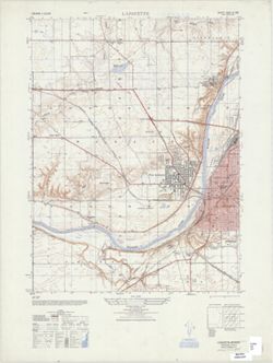
Printed with vegetation. Prepared under the direction of the Chief of Engineers by the Army Map Service (AM), Corps of Engineers, Department of the Army , ...
Call Number:
G4090 s25 .U5 Lafeyette West V
Caption:
Imprint: Washington, D.C. : Army Map Service, Corps of Engineers, Department of the Army, 1948.
Physical Description:
Dimensions: 56 x 45 cm or smaller and Scale: 1:25,000
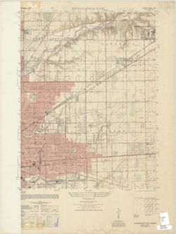
Prepared under the direction of the Chief of Engineers by the Army Map Service (AM), Corps of Engineers, Department of the Army. Relief shown by contours and...
Call Number:
G4090 s25 .U5 Indianapolis East 1948
Caption:
Imprint: Washington, D.C. : Army Map Service, Corps of Engineers, Department of the Army, 1949.
Physical Description:
Dimensions: 56 x 43 cm, on sheet 74 x 56 cm and Scale: 1:25,000
Jno. H. Renshawe, geographer in charge , control by Geo. T. Hawkins , topography by Chas. W. Goodlove. Filing title: Princeton, Ind.-Ill. [Edition of] 1901, ...
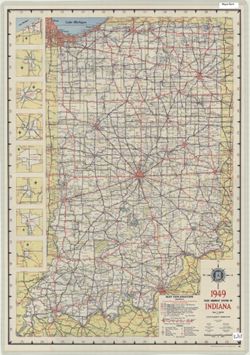
Panel title: 1949 Indiana official highway map. Relief shown by spot heights. Includes 8 local route maps. Index, distance chart, distance map of the United ...
Call Number:
G1403 .S7 1949
Caption:
Imprint: [Indianapolis] : State Highway Commission, [1949]
Physical Description:
Dimensions: 94 x 59 cm and Scale: Approximately 1:633,600
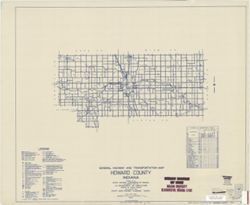
Geographic Subject: Howard County (Ind.) and Topical Subject: Roads
Creator:
Indiana. State Highway Commission (1919-1953)
Publisher:
State Highway Commission of Indiana
Date Created:
1949
Identifier:
VAC3073-M-01000
Genre:
Road maps
Geographic Location:
Coordinates: W0862200 W0855200 N0403400 N0402200
Related URL:
Catalog URL: https://iucat.iu.edu/catalog/5732724
Abstract:
Blueline. "State roads revised to January 1, 1949.: "Data obtained from State-wide Highway Planning Survey." Includes chart "Culture in u...
Call Number:
G4093.H7P2 1949 .I53
Caption:
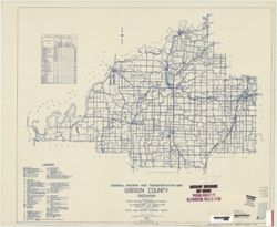
Imprint: [Indianapolis?] : State Highway Commission of Indiana, 1949.
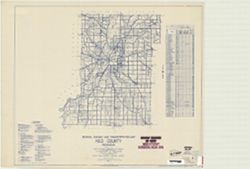
Geographic Subject: Fayette County (Ind.) and Topical Subject: Roads
Creator:
Indiana. State Highway Commission (1919-1953)
Publisher:
State Highway Commission of Indiana
Date Created:
1949
Identifier:
VAC3073-M-00960
Genre:
Road maps
Geographic Location:
Coordinates: W0851800 W0850200 N0394700 N0393200
Related URL:
Catalog URL: https://iucat.iu.edu/catalog/5704581
Abstract:
Blueline. "State roads revised to January 1, 1949." "Data obtained from State-wide Highway Planning Survey." Includes chart "Culture...
Call Number:
G4093.F3P2 1949 .I53
Caption:
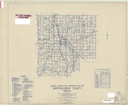
Imprint: [Indianapolis?] : State Highway Commission of Indiana. 1949.
Topical Subject: Roads and Geographic Subject: Bartholomew County (Ind.)
Creator:
Indiana. State Highway Commission (1919-1953)
Publisher:
Indiana. State Highway Commission (1919-1953)
Date Created:
1949
Identifier:
VAC3073-M-00950
Genre:
Road maps
Geographic Location:
Coordinates: W0860500 W0844100 N0392100 N0390200
Related URL:
Catalog URL: https://iucat.iu.edu/catalog/5359878
Abstract:
Blue line print. "State roads revised January 1, 1949." "1937." "Data obtained from State-wide Highway Planning Survey." "...
Call Number:
G4093.B3P2 1949 .I53
Caption:
Imprint: [Indianapolis?] : State Highway Commission of Indiana, 1949.
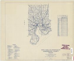
Geographic Subject: Gibson County (Ind.) and Topical Subject: Roads
Creator:
Indiana. State Highway Commission (1919-1953)
Publisher:
Indiana. State Highway Commission (1961-1981)
Date Created:
1949
Identifier:
VAC3073-M-00935
Genre:
Road maps
Geographic Location:
Coordinates: W0875900 W0871900 N0383200 N0381000
Related URL:
Catalog URL: https://iucat.iu.edu/catalog/5705940
Abstract:
Blueline. "State roads revised to January 1, 1949." "1937." "Data obtained from Statewide Highway Planning Survey." Includes lo...
Call Number:
G4093.G5P2 1949 .I53
Caption:
Imprint: [Indianapolis?] : State Highway Commission of Indiana, 1949.
![Indiana-Illinois Princeton quadrangle [1949 printing with minor corrections]](https://iiif.uits.iu.edu/iiif/2/2801qk457%2Ffiles%2Fcc6a6a50-c066-4d88-b5e1-b12fb8789f26/full/250,/0/default.jpg)