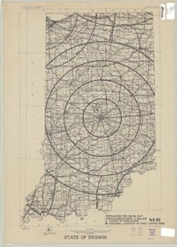
Topical Subject: National cemeteries and Geographic Subject: Indiana
Publisher:
[U.S. War Dept.?]
Date Created:
1940
Identifier:
VAC3073-M-00333
Genre:
Thematic maps
Geographic Location:
Coordinates: W0880700 W0844500 N0414500 N0375200
Related URL:
Catalog URL: https://iucat.iu.edu/catalog/5177103
Abstract:
Shows proposed National Cemetery in Indianapolis with 25 mile concentric rings showing distance from the proposed National Cemetery and other National Cemete...
Call Number:
G4091.G54 1940 .S73
Caption:
Imprint: [Washington, D.C.? : U.S. War Dept.?, 194-?]
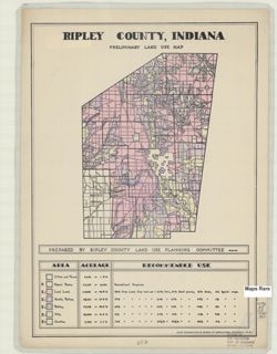
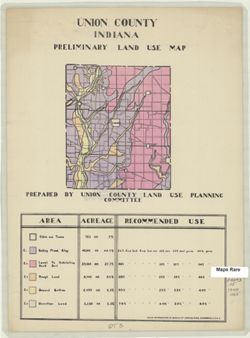
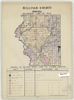
Geographic Subject: Ripley County (Ind.) and Topical Subject: Land use
Creator:
Ripley County (Ind.). Land Use Planning Committee
Publisher:
United States. Bureau of Agricultural Economics
Date Created:
1940
Identifier:
VAC3073-M-00030
Genre:
Thematic maps
Geographic Location:
Coordinates: W0852641 W0850354 N0391837 N0385446
Related URL:
Catalog URL: https://iucat.iu.edu/catalog/5126533
Abstract:
"Color reproduction by Bureau of Agricultural Economics, U.S.D.A." "8-21-40" Includes chart showing type of land use, acreage, and recomm...
Call Number:
G4093.R5 G4 1940 .R57
Caption:
Imprint: [Washington, D.C.?] : U.S. Bureau of Agricultural Economics, [1940]
Physical Description:
Dimensions: 21 x 16 cm, on sheet 38 x 28 cm and Scale: Scale not given.

![Washington County [Indiana] land use map : preliminary](https://iiif.uits.iu.edu/iiif/2/vq280q904%2Ffiles%2F783115ab-1c66-4d7e-b7d2-60280c29643b/full/250,/0/default.jpg)
![Warrick County [Indiana] land use map : preliminary](https://iiif.uits.iu.edu/iiif/2/1z40mw11c%2Ffiles%2Fdf0b1772-63ad-4eb7-a01c-aa6b48eaa924/full/250,/0/default.jpg)
![Vigo County [Indiana] land use map: preliminary](https://iiif.uits.iu.edu/iiif/2/gq67kv03f%2Ffiles%2Fbc5313f9-e338-4b17-a48d-60e4496abc8a/full/250,/0/default.jpg)
![Vanderburgh County [Indiana] preliminary land use map](https://iiif.uits.iu.edu/iiif/2/qf85pf475%2Ffiles%2F018f45ab-c6b4-40b1-9e75-dc08e8ae02ae/full/250,/0/default.jpg)
![Switzerland County [Indiana] preliminary land use map](https://iiif.uits.iu.edu/iiif/2/7p88dk86q%2Ffiles%2F702dbc2b-a33d-45c2-9347-ad26de2efd2e/full/250,/0/default.jpg)
![Spencer County [Indiana] land use map : preliminary](https://iiif.uits.iu.edu/iiif/2/1c18fj180%2Ffiles%2F9c0b4a8c-6bc8-420c-af21-908a4b5f3ba4/full/250,/0/default.jpg)