
Search Constraints
« Previous |
1 - 10 of 32
|
Next »
Search Results
-
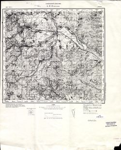
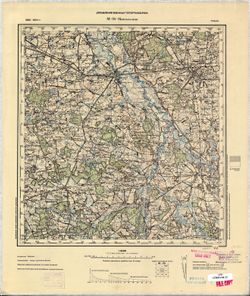
- Description:
- 1883
- Subject:
- Geographic Subject: Târgu Ocna, Topical Subject: Soviet Union, and Topical Subject: Maps
- Publisher:
- Генеральный штаб РККА
- Language:
- Russian
- Date Created:
- 1901
- Identifier:
- VAC9619-001591
- Genre:
- Topographic Maps and Military Maps
- Geographic Location:
- Coordinates: 46, 26.5, 46.3333, 27
- Related URL:
- Catalog URL: https://iucat.iu.edu/catalog/5020129 and Download GeoTIFF: https://drive.google.com/open?id=10x2oiAscdChrKJVEN93a3hEPHjpl_70K
- Abstract:
- Modern area represented: Târgu Ocna, Bacău county, Romania
- Call Number:
- G7000 s100 .S7 sheet L-35-66
- City:
- Тыргул Окна (Târgu Ocna)
- Copyright Holder:
- No Copyright - United States
- Country:
- Румыния (Romania)
- Physical Description:
- Scale: 1:100,000
- Persistent URL:
- http://purl.dlib.indiana.edu/iudl/images/VAC9619/VAC9619-001591
- Provenance:
- CIA Map Library, Atlasblatt
-
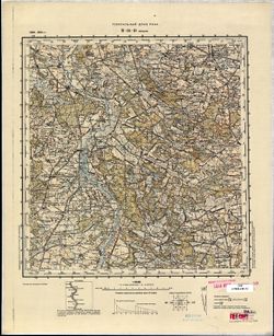
- Description:
- 1900
- Subject:
- Topical Subject: Maps, Geographic Subject: Skapiškis, and Topical Subject: Soviet Union
- Publisher:
- Генеральный штаб РККА
- Language:
- Russian
- Date Created:
- 1901
- Identifier:
- VAC9619-004006
- Genre:
- Military Maps and Topographic Maps
- Geographic Location:
- Coordinates: 55.667, 25, 56, 25.5
- Related URL:
- Download GeoTIFF: https://drive.google.com/file/d/1BBjlhpx-F8-dX1D0kxT586TRCxy3BDAj/view?usp=sharing and Catalog URL: https://iucat.iu.edu/catalog/5020129
- Abstract:
- Modern area represented: Skapiškis, Panevėžys, Lithuania
- Call Number:
- G7000 s100 .S7 sheet N-35-3
- City:
- Скапишкис (Skapiškis)
- Copyright Holder:
- No Copyright - United States
- Country:
- Литва (Lithuania)
- Physical Description:
- Scale: 1:100,000
- Persistent URL:
- http://purl.dlib.indiana.edu/iudl/images/VAC9619/VAC9619-004006
- Provenance:
- DMA Topographic Center, Army Map Service Library
-
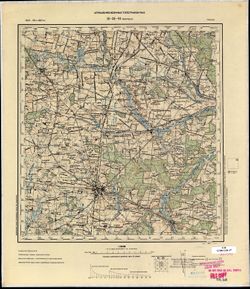
- Description:
- 1891
- Subject:
- Topical Subject: Soviet Union, Geographic Subject: Piotrków Trybunalski, and Topical Subject: Maps
- Publisher:
- Управление военных топографов РККА
- Language:
- Russian
- Date Created:
- 1901
- Identifier:
- VAC9619-002749
- Genre:
- Topographic Maps and Military Maps
- Geographic Location:
- Coordinates: 51.333, 19.5, 51.667, 20
- Related URL:
- Download GeoTIFF: https://drive.google.com/file/d/14ONzOcmLa3MBr_YV5eVDodlf1K31KL6Z/view?usp=sharing and Catalog URL: https://iucat.iu.edu/catalog/5020129
- Abstract:
- Modern area represented: Piotrków Trybunalski, Łódź province, Poland
- Call Number:
- G7000 s100 .S7 sheet M-34-16
- City:
- Пиотркув (Piotrków)
- Copyright Holder:
- No Copyright - United States
- Country:
- Польша (Poland)
- Physical Description:
- Scale: 1:100,000
- Persistent URL:
- http://purl.dlib.indiana.edu/iudl/images/VAC9619/VAC9619-002749
- Provenance:
- CIA Map Library
-
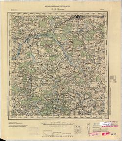
- Description:
- 1899
- Subject:
- Topical Subject: Soviet Union, Geographic Subject: Pabianice, and Topical Subject: Maps
- Publisher:
- Управление военных топографов РККА
- Language:
- Russian
- Date Created:
- 1901
- Identifier:
- VAC9619-002747
- Genre:
- Military Maps and Topographic Maps
- Geographic Location:
- Coordinates: 51.333, 19, 51.667, 19.5
- Related URL:
- Download GeoTIFF: https://drive.google.com/file/d/1F2jCRCRCFkmivVRaW8AfwwH3viu35wS1/view?usp=sharing and Catalog URL: https://iucat.iu.edu/catalog/5020129
- Abstract:
- Modern area represented: Pabianice, Łódź province, Poland
- Call Number:
- G7000 s100 .S7 sheet M-34-15
- City:
- Пабянице (Pabianice)
- Copyright Holder:
- No Copyright - United States
- Country:
- Польша (Poland)
- Physical Description:
- Scale: 1:100,000
- Persistent URL:
- http://purl.dlib.indiana.edu/iudl/images/VAC9619/VAC9619-002747
- Provenance:
- CIA Map Library
-
- Description:
- 1899
- Subject:
- Topical Subject: Soviet Union, Geographic Subject: Zduńska Wola, and Topical Subject: Maps
- Publisher:
- Управление военных топографов РККА
- Language:
- Russian
- Date Created:
- 1901
- Identifier:
- VAC9619-002745
- Genre:
- Military Maps and Topographic Maps
- Geographic Location:
- Coordinates: 51.333, 18.5, 51.667, 19
- Related URL:
- Download GeoTIFF: https://drive.google.com/file/d/1iDdCe8NMRim_cfPF8V1QFbtWePJh5N63/view?usp=sharing and Catalog URL: https://iucat.iu.edu/catalog/5020129
- Abstract:
- Modern area represented: Zduńska Wola, Łódź province, Poland
- Call Number:
- G7000 s100 .S7 sheet M-34-14
- City:
- Здуньска Воля (Zduńska Wola)
- Copyright Holder:
- No Copyright - United States
- Country:
- Польша (Poland)
- Physical Description:
- Scale: 1:100,000
- Persistent URL:
- http://purl.dlib.indiana.edu/iudl/images/VAC9619/VAC9619-002745
- Provenance:
- CIA Map Library
-
- Description:
- 1888
- Subject:
- Topical Subject: Maps, Geographic Subject: Gmina Błaszki, and Topical Subject: Soviet Union
- Publisher:
- Генеральный штаб РККА
- Language:
- Russian
- Date Created:
- 1901
- Identifier:
- VAC9619-002743
- Genre:
- Military Maps and Topographic Maps
- Geographic Location:
- Coordinates: 51.333, 18, 51.667, 18.5
- Related URL:
- Download GeoTIFF: https://drive.google.com/file/d/1VlqDWtwQ9iLMppisSzfrXjaJ1Epof7j4/view?usp=sharing and Catalog URL: https://iucat.iu.edu/catalog/5020129
- Abstract:
- Modern area represented: Gmina Błaszki, Łódź province, Poland
- Call Number:
- G7000 s100 .S7 sheet M-34-13
- City:
- Блашки (Błaszki)
- Copyright Holder:
- No Copyright - United States
- Physical Description:
- Scale: 1:100,000
- Persistent URL:
- http://purl.dlib.indiana.edu/iudl/images/VAC9619/VAC9619-002743
- Provenance:
- CIA Map Library
-

- Subject:
- Geographic Subject: Panemunėlis, Topical Subject: Maps, and Topical Subject: Soviet Union
- Publisher:
- Управление военных топографов
- Language:
- Russian
- Date Created:
- 1901
- Identifier:
- VAC9619-000394
- Genre:
- Topographic Maps and Military Maps
- Geographic Location:
- Coordinates: 55.833, 25.25, 56, 25.5
- Related URL:
- Catalog URL: http://iucat.iu.edu/catalog/5020131 and Download GeoTIFF: https://drive.google.com/open?id=18y4MJcwog3nQACJn9ht5hoLuXSjdvCqz
- Abstract:
- Modern area represented: Panemunėlis, Lithuania
- Call Number:
- G7000 s50 .S68 sheet N-35-3-B
- City:
- Понемунок (Poniemunek)
- Copyright Holder:
- No Copyright - United States
- Country:
- Литва (Lithuania)
- Physical Description:
- Scale: 1:50,000
- Persistent URL:
- http://purl.dlib.indiana.edu/iudl/images/VAC9619/VAC9619-000394
- Provenance:
- Army Map Service Library, OMAHA, Library of Congress Geography & Map Division
-
- Subject:
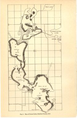
- Geographic Subject: James, Lake (Steuben County, Ind. : Lake), Topical Subject: Lakes, Topical Subject: IGS Annual Reports, Geographic Subject: Steuben Count...
- Publisher:
- Indiana. Department of Geology and Natural Resources
- Date Created:
- 1901
- Identifier:
- VAC3073-M-01178
- Genre:
- Thematic maps
- Geographic Location:
- Coordinates: W0850253 W0850033 N0414428 N0414050
- Related URL:
- Catalog URL: https://iucat.iu.edu/catalog/18190007
- Abstract:
- Depth shown by average depth range for each lake. Also shows information for Snow Lake and general locations of Mud Lake and Upper and Lower Otter Lakes. ...
- Call Number:
- G4092.J27 1900 .M37
- Caption:
- Imprint: [Indianapolis] : [Wm. B. Burford], [1901] and Imprint: [Indianapolis] : [Indiana, Department of Geology and Natural History], [1901]
- Physical Description:
- Dimensions: on sheet 23 x 15 cm and Scale: Approximately 1:32,000
- Alternate Identifier:
- Alternate ID: 390726IP and Title Control Number: a18190007
- Persistent URL:
- https://purl.dlib.indiana.edu/iudl/images/VAC3073/VAC3073-M-01178
- Provenance:
- 25th Annual Report (1900) / Indiana. Department of Geology and Natural Resources.
-
- Subject:
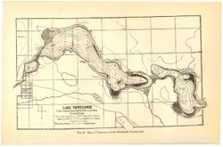
- Topical Subject: Lakes, Topical Subject: IGS Annual Reports, Geographic Subject: Tippecanoe, Lake (Ind.), and Geographic Subject: Kosciusko County (Ind.)
- Creator:
- Mase, Thomas L.
- Publisher:
- Indiana. Department of Geology and Natural Resources
- Date Created:
- 1901
- Identifier:
- VAC3073-M-01170
- Genre:
- Bathymetric maps
- Related URL:
- Catalog URL: https://iucat.iu.edu/catalog/4022271
- Call Number:
- QE109 .A2 1900 map p186
- Caption:
- Imprint: Indianapolis : Burford, 1901.
- Physical Description:
- Dimensions: 15 x 23 cm
- Persistent URL:
- https://purl.dlib.indiana.edu/iudl/images/VAC3073/VAC3073-M-01170
- Provenance:
- 25th Annual Report (1900) / Indiana. Department of Geology and Natural Resources.
-
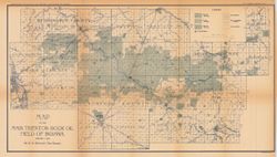
- Subject:
- Topical Subject: Oil fields and Geographic Subject: Indiana
- Creator:
- Blatchley, W. S. (Willis Stanley), 1859-1940
- Publisher:
- Indiana. Department of Geology and Natural Resources
- Date Created:
- 1901
- Identifier:
- VAC3073-M-01067
- Genre:
- Geological maps
- Geographic Location:
- Coordinates: W0854030 W0844820 N0404500 N0402200
- Related URL:
- Catalog URL: https://iucat.iu.edu/catalog/16078449
- Abstract:
- "January 1, 1901." Shows good, fair, and light oil territory, gas wells, dry and salt water territory, undrilled area, and pumping stations. Det...
- Call Number:
- G4091.H8 1900 .B5
- Caption:
- Imprint: [Indianapolis] : Department of Geology and Natural Resources of Indiana, [1901] and Imprint: Indianapolis, Ind. : Wm. B. Burford, [1901]
- Physical Description:
- Dimensions: 33 x 60 cm and Scale: Scale approximately 1:126,720. 2 miles = 1 in.
- Alternate Identifier:
- Alternate ID: 390726IP and Title Control Number: a16078449
- Persistent URL:
- https://purl.dlib.indiana.edu/iudl/images/VAC3073/VAC3073-M-01067
- Provenance:
- 25th Annual Report (1900) / Indiana. Department of Geology and Natural Resources.

- « Previous
- Next »
- 1
- 2
- 3
- 4