
Search Constraints
You searched for:
Publisher
Indiana. Geological Survey
Remove constraint Publisher: Indiana. Geological Survey
« Previous |
1 - 10 of 77
|
Next »
Search Results
-
- Subject:
- Geographic Subject: Indiana and Topical Subject: Mines and mineral resources
- Creator:
- Indiana. Geological Survey
- Publisher:
- Indiana. Geological Survey
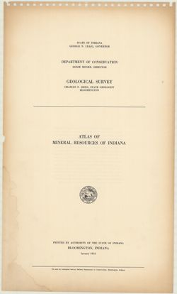
- Date Created:
- 1953
- Identifier:
- VAC3073-M-01193
- Genre:
- Atlases and Mine maps
- Geographic Location:
- Coordinates: W0880500 W0844700 N0414500 N0374600
- Related URL:
- Catalog URL: https://iucat.iu.edu/catalog/22238
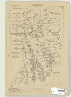
- Abstract:
- Letter inserted indicating map no. 10 last in series,, map dated 1958, letter dated 1962.
- Call Number:
- G1401.H1 A! 1953
- Caption:
- Imprint: Bloomington, Indiana : Indiana Geological Survey, 1953
- Physical Description:
- Dimensions: 56 cm and Scale: Scales differ.
- Persistent URL:
- https://purl.dlib.indiana.edu/iudl/images/VAC3073/VAC3073-M-01193
-
- Subject:
- Topical Subject: Geology and Geographic Subject: Indiana
- Creator:
- Patton, John B. (John Barratt), 1915-
- Publisher:
- Indiana. Geological Survey
- Date Created:
- 1956
- Identifier:
- VAC3073-M-00212
- Genre:
- Geological maps
- Geographic Location:
- Coordinates: W0880000 W0844500 N0414500 N0375200
- Related URL:
- Catalog URL: https://iucat.iu.edu/catalog/5888483
- Abstract:
- "Base from Map of Indiana, 1950 edition, published by the U.S. Geological Survey. Minor revisions and additions made from Indiana Department of Conserva...
- Call Number:
- G4091 .C5 1956 .P3
- Caption:
- Imprint: [Bloomington] : Indiana Geological Survey, 1956.
- Physical Description:
- Dimensions: 59 x 31 cm and Scale: 1:1,000,000
- Alternate Identifier:
- Title Control Number: a5888483
- Persistent URL:
- https://purl.dlib.indiana.edu/iudl/images/VAC3073/VAC3073-M-00212
-
- Subject:
- Geographic Subject: Indiana, Geographic Subject: Illinois, Topical Subject: Geology, Stratigraphic, and Topical Subject: Geology
- Creator:
- Indiana. Geological Survey, Bleuer, N. K. (Ned Kermit), 1943-, Lineback, Jerry A. (Jerry Alvin), Hill, John R,, Gray, Henry Hamilton, 1922-, and Illinois Sta...
- Publisher:
- Indiana. Geological Survey
- Date Created:
- 1979
- Identifier:
- VAC3073-M-01251
- Genre:
- Quadrangle maps, Geological maps, and Geological cross-sections
- Geographic Location:
- Coordinates: W0880000 W0860000 N0400000 N0390000
- Related URL:
- Catalog URL: https://iucat.iu.edu/catalog/18437113
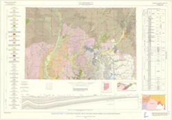
- Abstract:
- Indianapolis sheet. 1979 edition. Transverse Mercator projection. Geology compiled by H. H. Gray (Indiana) and J. A. Lineback (Illinois) from published and o...
- Call Number:
- G4091.C5 s250 .I5 Indianapolis 1979
- Caption:
- Imprint: [Bloomington] : Indiana Geological Survey, 1979
- Physical Description:
- Scale: 1:250,000. Vertical scale approximately 1:3,800 and Dimensions: 66 x 102 cm
- Alternate Identifier:
- Title Control Number: a18437113
- Persistent URL:
- https://purl.dlib.indiana.edu/iudl/images/VAC3073/VAC3073-M-01251
- Provenance:
- Indiana. Geological Survey. Regional geologic map , no. 1.
-
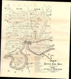
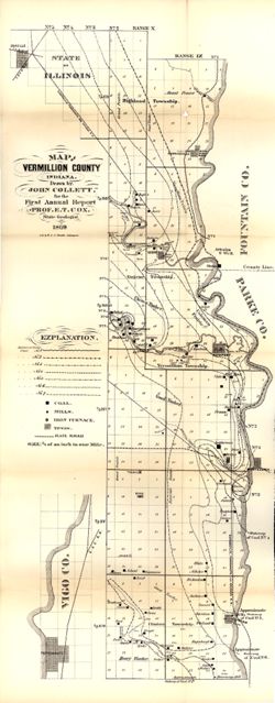
- Subject:
- Geographic Subject: Vanderburgh County (Ind.), Topical Subject: Coal mines and mining, Topical Subject: Mines and mineral resources, Topical Subject: Geology...
- Creator:
- Collett, John, 1828-1899
- Publisher:
- Indiana. Geological Survey
- Date Created:
- 1876
- Identifier:
- VAC3073-M-01146
- Genre:
- Geological maps
- Geographic Location:
- Coordinates: W0874203 W0872658 N0381006 N0374933
- Related URL:
- Catalog URL: https://iucat.iu.edu/catalog/18349316
- Abstract:
- Compiled for the 7th annual report of E.T. Cox, State Geologist , geology by Prof. John Collett, 1875. Relief shown by hachures. Shows cities and towns, rail...
- Call Number:
- G4093.V3C5 1875 .C6
- Caption:
- Imprint: [Indianapolis] : [Geological Survey of Indiana], [1876] and Imprint: [Indianapolis] : [Sentinel Company, printers], [1876]
- Physical Description:
- Scale: Approximately 1:130,000 and Dimensions: on sheet 41 x 31 cm
- Alternate Identifier:
- Alternate ID: 390723IP and Title Control Number: a18349316
- Persistent URL:
- https://purl.dlib.indiana.edu/iudl/images/VAC3073/VAC3073-M-01146
- Provenance:
- 7th Annual Report (1875) / Indiana. Geological Survey.
-
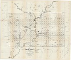
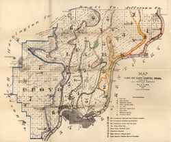
- Subject:
- Topical Subject: Mines and mineral resources, Geographic Subject: Greene County (Ind.), and Topical Subject: IGS Annual Reports
- Creator:
- Levette, G. M. (Gilbert M.)
- Publisher:
- Indiana. Geological Survey
- Date Created:
- 1869
- Identifier:
- VAC3073-M-01449
- Genre:
- Thematic maps
- Geographic Location:
- Coordinates: W0871431 W0864053 N0391018 N0385418
- Related URL:
- Catalog URL: https://iucat.iu.edu/catalog/18189063
- Abstract:
- Shows towns, railroads, coal and iron ore, mills, furnaces, and stone quarries. "For the first annual report of Prof. E.T. Cox, State Geologist." ...
- Call Number:
- G4093.G7H1 1869 .L3
- Caption:
- Imprint: [Indianapolis] : [Alexander M. Conner], [1869]
- Physical Description:
- Dimensions: 61 x 71 cm and Scale: Approximately 1:85,000
- Alternate Identifier:
- Title Control Number: a18189063
- Persistent URL:
- https://purl.dlib.indiana.edu/iudl/images/VAC3073/VAC3073-M-01449
- Provenance:
- 1st Annual Report (1869) / Indiana. Geological Survey
-
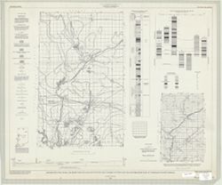
- Subject:
- Geographic Subject: Warren County (Ind.), Topical Subject: Coal mines and mining, Geographic Subject: Vermillion County (Ind.), and Geographic Subject: Fount...
- Creator:
- Hutchison, Harold C. (Harold Christy), 1925-
- Publisher:
- Indiana. Geological Survey
- Date Created:
- 1961
- Identifier:
- VAC3073-M-00418
- Genre:
- Mine maps
- Geographic Location:
- Coordinates: W0873200 W0870533 N0402800 N0395645
- Related URL:
- Catalog URL: https://iucat.iu.edu/catalog/4898738
- Abstract:
- "Preliminary coal map no. 9"--Margin. Includes 1 ancillary map, 1 diagram showing township enumeration, 1 index map, 1 stratigraphic column, and 1 ...
- Call Number:
- G4093.F6H9 1961 .H88
- Caption:
- Imprint: Bloomington : Indiana Dept. of Conservation, Geological Survey, 1961.
- Physical Description:
- Scale: Scales differ. and Dimensions: 61 x 72 cm
- Alternate Identifier:
- Title Control Number: a4898738
- Persistent URL:
- https://purl.dlib.indiana.edu/iudl/images/VAC3073/VAC3073-M-00418
-
- Subject:
- Topical Subject: Geology, Geographic Subject: Clark County (Ind.), Topical Subject: Mines and mineral resources, Geographic Subject: Floyd County (Ind.), and...
- Creator:
- Cox, E. T. (Edward Travers), 1821-1907 and Borden, W. W. (William Wesley), 1823-1906
- Publisher:
- Indiana. Geological Survey
- Date Created:
- 1874
- Identifier:
- VAC3073-M-01155
- Genre:
- Geological maps
- Geographic Location:
- Coordinates: W0860258 W0852426 N0383636 N0380900
- Related URL:
- Catalog URL: https://iucat.iu.edu/catalog/18318611
- Abstract:
- Prepared for the 5th annual report of Prof. E.T. Cox, State Geologist, 1873 , geology by W.W. Borden. Relief shown by hachures. Shows cities and towns, railr...
- Call Number:
- G4093.C4C5 1873 .B6
- Caption:
- Imprint: [Indianapolis] : [Geological Survey of Indiana], [1874] and Imprint: [Indianapolis] : [Sentinel Co., printers], [1874]
- Physical Description:
- Dimensions: on sheet 41 x 49 cm and Scale: Approximately 1:130,000
- Alternate Identifier:
- Alternate ID: 390723IP and Title Control Number: a18318611
- Persistent URL:
- https://purl.dlib.indiana.edu/iudl/images/VAC3073/VAC3073-M-01155
- Provenance:
- 5th Annual Report (1873) / Indiana. Geological Survey.
-
- Subject:
- Topical Subject: IGS Annual Reports, Topical Subject: Coal mines and mining, Topical Subject: Lumber trade, Geographic Subject: Vigo County (Ind.), Topical S...
- Creator:
- Collett, John, 1828-1899
- Publisher:
- Indiana. Geological Survey
- Date Created:
- 1869
- Identifier:
- VAC3073-M-01158
- Genre:
- Geological maps
- Geographic Location:
- Coordinates: W0873159 W0872113 N0400854 N0393626
- Related URL:
- Catalog URL: https://iucat.iu.edu/catalog/16799192
- Abstract:
- Drawn by John Collett for the 1st annual report of Prof. E.T. Cox, State Geologist, 1869 , lith. by W & J. Braden. Shows towns, railroads, coal, mills...
- Call Number:
- G4093.V4 1869 .C6
- Caption:
- Imprint: [Indianapolis] : [Alexander H. Conner, State Printer], [1869] and Imprint: [Indianapolis] : [Geological Survey of Indiana], [1869]
- Physical Description:
- Dimensions: on sheet 77 x 32 cm and Scale: Approximately 1:85,000. 3/4 of an inch to one mile
- Alternate Identifier:
- Title Control Number: a16799192 and Alternate ID: 390720IP
- Persistent URL:
- https://purl.dlib.indiana.edu/iudl/images/VAC3073/VAC3073-M-01158
- Provenance:
- 1st Annual Report (1869) / Indiana. Geological Survey
-
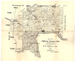
- Subject:
- Topical Subject: IGS Annual Reports, Topical Subject: Real property, Geographic Subject: Jefferson County (Ind.), and Topical Subject: Landowners
- Creator:
- Borden, W. W. (William Wesley), 1823-1906
- Publisher:
- Indiana. Geological Survey
- Date Created:
- 1875
- Identifier:
- VAC3073-M-01172
- Genre:
- Cadastral maps
- Geographic Location:
- Coordinates: W0853944 W0851048 N0385447 N0383436
- Related URL:
- Catalog URL: https://iucat.iu.edu/catalog/18318691
- Abstract:
- Prepared for the sixth annual report of E.T. Cox, State Geologist, geology by W.W. Borden. Relief shown by hachures. Shows cities and towns, railroads, and l...
- Call Number:
- G4093.J5C5 1874 .B6
- Caption:
- Imprint: [Indianapolis, Indiana] : [Sentinel Co., printers], [1875] and Imprint: [Indianapolis] : [Geological Survey of Indiana], [1875]
- Physical Description:
- Dimensions: 40 x 35 cm, on sheet 39 x 47 cm and Scale: Approximately 1:130,000
- Alternate Identifier:
- Alternate ID: 390723IP and Title Control Number: a18318691
- Persistent URL:
- https://purl.dlib.indiana.edu/iudl/images/VAC3073/VAC3073-M-01172
- Provenance:
- 6th Annual Report (1874) / Indiana. Geological Survey.
-
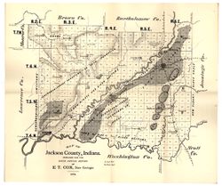
- Subject:
- Geographic Subject: Jackson County (Ind.), Topical Subject: Geology, and Topical Subject: IGS Annual Reports
- Creator:
- Cox, E. T. (Edward Travers), 1821-1907
- Publisher:
- Indiana. Geological Survey
- Date Created:
- 1875
- Identifier:
- VAC3073-M-01177
- Genre:
- Geological maps
- Geographic Location:
- Coordinates: W0861905 W0854741 N0390414 N0384329
- Related URL:
- Catalog URL: https://iucat.iu.edu/catalog/18318685
- Abstract:
- Prepared for the sixth annual report of E[.]T. Cox, State Geologist, 1874. Relief shown by hachures. Shows cities and towns, railroads, geology of the region...
- Call Number:
- G4093.J2C5 1874 .C6
- Caption:
- Imprint: [Indianapolis] : [Geological Survey of Indiana], [1875] and Imprint: [Indianapolis] : [Sentinel Co., printers], [1875]
- Physical Description:
- Scale: Approximately 1:130,000 and Dimensions: on sheet 40 x 47 cm
- Alternate Identifier:
- Title Control Number: a18318685 and Alternate ID: 390723IP
- Persistent URL:
- https://purl.dlib.indiana.edu/iudl/images/VAC3073/VAC3073-M-01177
- Provenance:
- 6th Annual Report (1874) / Indiana. Geological Survey.
