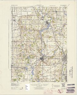
Topical Subject: Vegetation mapping, Geographic Subject: Saint Joseph County (Mich.), Geographic Subject: Cass County (Mich.), and Geographic Subject: Elkhar...
Creator:
Michigan. State Highway Department and Geological Survey (U.S.)
Publisher:
Geological Survey (U.S.)
Date Created:
1973
Identifier:
VAC3073-M-01507
Genre:
15 minute topographic maps, Quadrangle maps, and Topographic maps
Mapped, edited, and published by the Geological Survey. Filing title: Vandalia, Mich.-Ind. Standard map series designation: AMS (Series) V762 3867 IV. [Editi...
Mapped, edited, and published by the Geological Survey. Filing title: Vandalia, Mich.-Ind. Standard map series designation: AMS (Series) V762 3867 IV. [Editi...
Geographic Subject: Saint Joseph County (Mich.), Geographic Subject: Cass County (Mich.), Topical Subject: Vegetation mapping, and Geographic Subject: Elkhar...
Creator:
Geological Survey (U.S.) and Michigan. State Highway Department
Publisher:
Geological Survey (U.S.)
Date Created:
1959
Identifier:
VAC3073-M-01337
Genre:
15 minute topographic maps, Topographic maps, and Quadrangle maps
Mapped, edited, and published by the Geological Survey. Filing title: Vandalia, Mich.-Ind. Standard map series designation: AMS (Series) V762 3867 IV. [Editi...
Geographic Subject: Knox County (Ind.), Geographic Subject: Wabash County (Ill.), Topical Subject: Vegetation mapping, and Geographic Subject: Gibson County ...
Creator:
Geological Survey (U.S.), Illinois State Geological Survey, and United States. Army Map Service
Publisher:
Geological Survey (U.S.)
Date Created:
1965
Identifier:
VAC3073-M-01388
Genre:
15 minute topographic maps, Quadrangle maps, and Topographic maps
Mapped, edited and published by the Geological Survey , Illinois area mapped in cooperation with State of Illinois Geological Survey. Filing title: Princeton...
Geographic Subject: Gibson County (Ind.), Geographic Subject: Knox County (Ind.), Geographic Subject: Wabash County (Ill.), and Topical Subject: Vegetation m...
Creator:
Geological Survey (U.S.), United States. Army Map Service, and Illinois State Geological Survey
Publisher:
Geological Survey (U.S.)
Date Created:
1965
Identifier:
VAC3073-M-01504
Genre:
Topographic maps, 15 minute topographic maps, and Quadrangle maps
Mapped, edited and published by the Geological Survey , Illinois area mapped in cooperation with State of Illinois Geological Survey. Filing title: Princeton...
Mapped, edited and published by the Geological Survey , Illinois area mapped in cooperation with State of Illinois Geological Survey. Filing title: Princeton...
Geographic Subject: Gibson County (Ind.), Topical Subject: Vegetation mapping, Geographic Subject: Wabash County (Ill.), and Geographic Subject: Knox County ...
Creator:
Geological Survey (U.S.), United States. Army Map Service, and Illinois State Geological Survey
Publisher:
Geological Survey (U.S.)
Date Created:
1964
Identifier:
VAC3073-M-01387
Genre:
Quadrangle maps, 15 minute topographic maps, and Topographic maps
Mapped, edited and published by the Geological Survey , Illinois area mapped in cooperation with State of Illinois Geological Survey. Filing title: Princeton...
Geographic Subject: Knox County (Ind.), Geographic Subject: Gibson County (Ind.), Geographic Subject: Wabash County (Ill.), and Topical Subject: Vegetation m...
Creator:
Illinois State Geological Survey, Geological Survey (U.S.), and United States. Army Map Service
Publisher:
Geological Survey (U.S.)
Date Created:
1964
Identifier:
VAC3073-M-01386
Genre:
15 minute topographic maps, Topographic maps, and Quadrangle maps
Mapped, edited and published by the Geological Survey , Illinois area mapped in cooperation with State of Illinois Geological Survey. Filing title: Princeton...
Prepared under the direction of the Chief of Engineers, U. S. Army, 1943. Army Map Service, Quincy unit. At head of map: Michigan 1:62,500. Filing title: Nil...
Call Number:
G4090 s62 .G4 Niles 1943
Caption:
Imprint: Washington, D.C. : Army Map Service, U.S. Army, 1943
Physical Description:
Scale: 1:62,500 and Dimensions: 45 x 42 cm or smaller
Topical Subject: Vegetation mapping, Geographic Subject: Gibson County (Ind.), Geographic Subject: Posey County (Ind.), and Geographic Subject: White County ...
Creator:
Geological Survey (U.S.) and Illinois State Geological Survey
Publisher:
Geological Survey (U.S.)
Date Created:
1963
Identifier:
VAC3073-M-01356
Genre:
Topographic maps, Quadrangle maps, and 15 minute topographic maps
Mapped, edited, and published by the Geological Survey , Illinois area mapped in cooperation with State of Illinois Geological Survey. Filing title: New Harm...

![Vandalia quadrangle, Michigan-Indiana : 15 minute series (topographic) [1973 reprint with vegetation]](https://iiif.uits.iu.edu/iiif/2/0g355j55q%2Ffiles%2F59353208-0771-4acc-8e57-7c989a623800/full/250,/0/default.jpg)

![Vandalia quadrangle, Michigan-Indiana : 15 minute series (topographic) [1959 reprint without vegetation]](https://iiif.uits.iu.edu/iiif/2/9593vz28s%2Ffiles%2F4f6d2df8-a9b9-45fc-993f-1949cda1ffbb/full/250,/0/default.jpg)
![Vandalia quadrangle, Michigan-Indiana : 15 minute series (topographic) [1959 reprint with vegetation]](https://iiif.uits.iu.edu/iiif/2/9019t543m%2Ffiles%2Fd71ad7ee-44b6-4efe-9cbc-388b2c880604/full/250,/0/default.jpg)
![Princeton quadrangle, Indiana-Illinois : 15 minute series (topographic) [1965 reprint with vegetation]](https://iiif.uits.iu.edu/iiif/2/sx61fr138%2Ffiles%2F603798b1-0337-482a-9bb7-934a41ad4b2b/full/250,/0/default.jpg)
![Princeton quadrangle, Indiana-Illinois : 15 minute series (topographic) [1965 reprint with vegetation]](https://iiif.uits.iu.edu/iiif/2/7m01cp47j%2Ffiles%2Fdc826735-24b7-4c3f-9d9b-87ad67efd7e8/full/250,/0/default.jpg)
![Princeton quadrangle, Indiana-Illinois : 15 minute series (topographic) [1965 printing without vegetation]](https://iiif.uits.iu.edu/iiif/2/70796d47m%2Ffiles%2Fedc5c6d4-9f41-4b7c-9447-a370bfe906e0/full/250,/0/default.jpg)
![Princeton quadrangle, Indiana-Illinois : 15 minute series (topographic) [1964 printing with vegetation]](https://iiif.uits.iu.edu/iiif/2/m900px89p%2Ffiles%2Fe957c77d-db8c-42d6-aef0-05abd0d3301b/full/250,/0/default.jpg)
![Princeton quadrangle, Indiana-Illinois : 15 minute series (topographic) [1964 printing with vegetation]](https://iiif.uits.iu.edu/iiif/2/ng452m35w%2Ffiles%2F49af6c65-fc22-44ea-8486-c7923f5afb8b/full/250,/0/default.jpg)
![New Harmony quadrangle, Indiana--Illinois, 1959 : 15 minute series (topographic) [1963 reprint with vegetation]](https://iiif.uits.iu.edu/iiif/2/n296z235w%2Ffiles%2Faf8714ac-51b2-4e50-bb3a-3e3e07d338a7/full/250,/0/default.jpg)