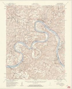
Geographic Subject: Breckinridge County (Ky.), Geographic Subject: Perry County (Ind.), Geographic Subject: Harrison County (Ind.), Geographic Subject: Meade...
Creator:
United States. Army Map Service and Geological Survey (U.S.)
Publisher:
Geological Survey (U.S.)
Date Created:
1959
Identifier:
VAC3073-M-01312
Genre:
Topographic maps, Quadrangle maps, and 15 minute topographic maps
Mapped by the Geological Survey and the Army Map Service. Filing title: Alton, Ind.--Ky. Polyconic projection. Relief shown by contours and spot heights. Inc...
Mapped by the Geological Survey and the Army Map Service. Filing title: Alton, Ind.--Ky. Polyconic projection. Relief shown by contours and spot heights. Inc...
Filing title: Cassopolis, Mich.--Ind. Edition of 1947. Polyconic projection. Indiana portion not shown, shown on 1:24,000 scale maps of South Bend West and O...
Call Number:
G4090 s62 .G4 Cassopolis 1947
Caption:
Imprint: Washington, D.C. : U.S. Geological Survey, 1947.
Physical Description:
Dimensions: 45 x 42 cm or smaller and Scale: 1:62,500
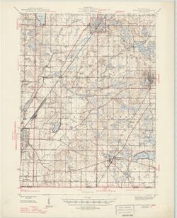
Geographic Subject: Danville Region (Ill.), Geographic Subject: Vermillion County (Ind.), and Geographic Subject: Vermilion County (Ill.)
Creator:
Lloyd, W. J. (Topographer), Illinois. Department of Registration and Education, Geological Survey (U.S.), Illinois State Geological Survey, Hawkins, Geo. T. ...
Publisher:
Geological Survey (U.S.)
Date Created:
1946
Identifier:
VAC3073-M-01311
Genre:
15 minute topographic maps, Quadrangle maps, and Topographic maps
Jno. H. Renshawe, geographer in charge , control by U.S. Lake Survey and Geo. T. Hawkins , topography by W. J. Lloyd. Edition of Nov. 1900, reprinted 1946 wi...
Geographic Subject: Johnson County (Ind.), Geographic Subject: Shelby County (Ind.), Geographic Subject: Bartholomew County (Ind.), and Topical Subject: Vege...
Creator:
Geological Survey (U.S.) and United States. Army. Corps of Engineers
Geographic Subject: Hardin County (Ky.), Geographic Subject: Harrison County (Ind.), Topical Subject: Vegetation mapping, Geographic Subject: Meade County (K...
Mapped by the Army Map Service , published for civil use by the Geological Survey. Filing title: Ekron, Ky.-Ind. Polyconic projection. Relief shown by contou...
Call Number:
G4090 s62 .G4 Ekron 1947 rep 1959 V
Caption:
Imprint: Washington, D.C. : published for civil use by the U.S. Geological Survey, 1959.
Physical Description:
Dimensions: 45 x 42 cm or smaller and Scale: 1:62,500
Geographic Subject: Brown County (Ind.), Geographic Subject: Bartholomew County (Ind.), Geographic Subject: Johnson County (Ind.), and Topical Subject: Veget...
Creator:
Geological Survey (U.S.) and United States. Army. Corps of Engineers
Filing title: Franklin, Ind. Mapped, edited, and published by Geological Survey. Edition of 1950. Polyconic projection. Relief shown by contours and spot hei...
Filing title: Franklin, Ind. Mapped, edited, and published by Geological Survey. Edition of 1950. Polyconic projection. Relief shown by contours and spot hei...
Geographic Subject: Brown County (Ind.), Geographic Subject: Johnson County (Ind.), Geographic Subject: Bartholomew County (Ind.), and Topical Subject: Veget...
Creator:
United States. Army. Corps of Engineers and Geological Survey (U.S.)
Filing title: Franklin, Ind. Mapped, edited, and published by Geological Survey. Edition of 1950. Polyconic projection. Relief shown by contours and spot hei...


![Alton quadrangle, Indiana--Kentucky : 15 minute series (topographic) [Vegetation version]](https://iiif.uits.iu.edu/iiif/2/ng452m33b%2Ffiles%2F49c9606f-c7c7-4f10-807b-1b5949009698/full/250,/0/default.jpg)
![Danville quadrangle, Illinois-Indiana : topographic sheet [1946 reprint]](https://iiif.uits.iu.edu/iiif/2/dz011t65f%2Ffiles%2F0d88511d-4915-434c-875f-219d4a99befe/full/250,/0/default.jpg)
![Edinburg Quadrangle Indiana : 15 minute series (topographic) [1950 printing with vegetation]](https://iiif.uits.iu.edu/iiif/2/4b29c880r%2Ffiles%2F58f84ee1-c680-40d2-9a78-baf3613c076f/full/250,/0/default.jpg)
![Edinburg Quadrangle Indiana : 15 minute series (topographic) [1950 printing without vegetation]](https://iiif.uits.iu.edu/iiif/2/3b592c294%2Ffiles%2F06928e89-6508-4c49-a4ff-7f390a205f57/full/250,/0/default.jpg)
![Ekron quadrangle, Kentucky-Indiana : 15 minute series (topographic) [1959 printing with vegetation]](https://iiif.uits.iu.edu/iiif/2/c534gs22s%2Ffiles%2Fb6d7f856-1470-4ba1-a8ae-e16f6e63c025/full/250,/0/default.jpg)
![Franklin Quadrangle Indiana : 15 minute series (topographic) [1950 printing with vegetation]](https://iiif.uits.iu.edu/iiif/2/s1785q21n%2Ffiles%2F2980480d-4dc3-4d46-8d25-f5ccac9e74ef/full/250,/0/default.jpg)
![Franklin Quadrangle Indiana : 15 minute series (topographic) [1950 printing without vegetation]](https://iiif.uits.iu.edu/iiif/2/gq67kv050%2Ffiles%2F1b2dc3c9-fa67-4787-9ad0-8c7dd5aad08b/full/250,/0/default.jpg)
![Franklin Quadrangle Indiana : 15 minute series (topographic) [1964 reprint with vegetation]](https://iiif.uits.iu.edu/iiif/2/6q183p48p%2Ffiles%2Fc56a46c5-d4c7-4d8d-bc73-62e73b26e4c3/full/250,/0/default.jpg)