Geographic Subject: Knox County (Ind.), Geographic Subject: Gibson County (Ind.), Geographic Subject: Wabash County (Ill.), and Topical Subject: Vegetation m...
Creator:
Illinois State Geological Survey, Geological Survey (U.S.), and United States. Army Map Service
Publisher:
Geological Survey (U.S.)
Date Created:
1964
Identifier:
VAC3073-M-01386
Genre:
15 minute topographic maps, Topographic maps, and Quadrangle maps
Mapped, edited and published by the Geological Survey , Illinois area mapped in cooperation with State of Illinois Geological Survey. Filing title: Princeton...
Mapped, edited and published by the Geological Survey , Illinois area mapped in cooperation with State of Illinois Geological Survey. Filing title: Princeton...
Geographic Subject: Knox County (Ind.), Geographic Subject: Wabash County (Ill.), Topical Subject: Vegetation mapping, and Geographic Subject: Gibson County ...
Creator:
Geological Survey (U.S.), Illinois State Geological Survey, and United States. Army Map Service
Publisher:
Geological Survey (U.S.)
Date Created:
1965
Identifier:
VAC3073-M-01388
Genre:
15 minute topographic maps, Quadrangle maps, and Topographic maps
Mapped, edited and published by the Geological Survey , Illinois area mapped in cooperation with State of Illinois Geological Survey. Filing title: Princeton...
Geographic Subject: Gibson County (Ind.), Geographic Subject: Knox County (Ind.), Geographic Subject: Wabash County (Ill.), and Topical Subject: Vegetation m...
Creator:
Geological Survey (U.S.), United States. Army Map Service, and Illinois State Geological Survey
Publisher:
Geological Survey (U.S.)
Date Created:
1965
Identifier:
VAC3073-M-01504
Genre:
Topographic maps, 15 minute topographic maps, and Quadrangle maps
Mapped, edited and published by the Geological Survey , Illinois area mapped in cooperation with State of Illinois Geological Survey. Filing title: Princeton...
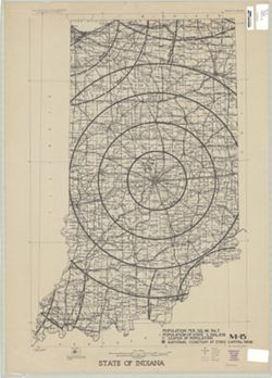
Compiled in 1970. Includes population key. Source data U.S. Dept. of the Interior - Geological Survey topographic maps. U.S. Dept of the Army - Corps of Engi...
Call Number:
G4091.C2 1973 .G4
Caption:
Imprint: [Reston, Va.] : U.S. Geological Survey, 1973
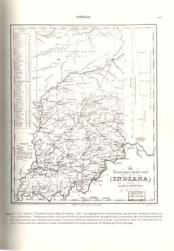
Variant title: Travellers pocket map of Indiana with its roads and distances. Relief shown by profile. Shows existing and proposed canals and railroads as we...
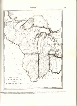
Relief shown by hachures. Prime meridians: London and Philadelphia. Reprint of: The Upper territories of the United States. In General atlas of the world and...
Call Number:
QH75 .A4 No. 1200-IN
Caption:
Imprint: [Reston, Va.] : [The Survey], [1988]
Physical Description:
Dimensions: 29 cm or less and Scale: Indeterminable
Alternate Identifier:
Title Control Number: a18416533 and Alternate ID: 358171IP

![Princeton quadrangle, Indiana-Illinois : 15 minute series (topographic) [1964 printing with vegetation]](https://iiif.uits.iu.edu/iiif/2/ng452m35w%2Ffiles%2F49af6c65-fc22-44ea-8486-c7923f5afb8b/full/250,/0/default.jpg)
![Princeton quadrangle, Indiana-Illinois : 15 minute series (topographic) [1965 printing without vegetation]](https://iiif.uits.iu.edu/iiif/2/70796d47m%2Ffiles%2Fedc5c6d4-9f41-4b7c-9447-a370bfe906e0/full/250,/0/default.jpg)
![Princeton quadrangle, Indiana-Illinois : 15 minute series (topographic) [1965 reprint with vegetation]](https://iiif.uits.iu.edu/iiif/2/sx61fr138%2Ffiles%2F603798b1-0337-482a-9bb7-934a41ad4b2b/full/250,/0/default.jpg)
![Princeton quadrangle, Indiana-Illinois : 15 minute series (topographic) [1965 reprint with vegetation]](https://iiif.uits.iu.edu/iiif/2/7m01cp47j%2Ffiles%2Fdc826735-24b7-4c3f-9d9b-87ad67efd7e8/full/250,/0/default.jpg)