
Search Constraints
You searched for:
Country
СССР (USSR)
Remove constraint Country: СССР (USSR)
Publisher
Главное управление государственной съемки и картографии НКВД СССР
Remove constraint Publisher: Главное управление государственной съемки и картографии НКВД СССР
« Previous |
1 - 10 of 75
|
Next »
Search Results
-
- Description:
- 1934
- Subject:
- Topical Subject: Soviet Union, Topical Subject: Maps, and Geographic Subject: Aktogay district
- Publisher:
- Главное управление государственной съемки и картографии НКВД СССР
- Language:
- Russian
- Date Created:
- 1938
- Identifier:
- VAC9619-002537
- Genre:
- Military Maps and Topographic Maps
- Geographic Location:
- Coordinates: 47.333, 75, 47.667, 75.5
- Related URL:
- Download GeoTIFF: https://drive.google.com/file/d/1HvUN0cYNLD3PZs0CPw1JqQCCRNWdkeVH/view?usp=sharing and Catalog URL: https://iucat.iu.edu/catalog/5020129
- Abstract:
- Modern area represented: Aktogay district, Karaganda oblast, Kazakhstan
- Call Number:
- G7000 s100 .S7 sheet L-43-19
- Copyright Holder:
- No Copyright - United States
- Country:
- СССР (USSR)
- State/Province:
- Коунрадский район (Kounrad district) and Карагандинская область (Karaganda oblast)
- Physical Description:
- Scale: 1:100,000
- Persistent URL:
- http://purl.dlib.indiana.edu/iudl/images/VAC9619/VAC9619-002537
- Provenance:
- DMA Topographic Center, Library of Congress G & M Division, Army Map Service Library, Auswärtiges Amt. Geographischer Dienst, OMAHA
-
- Description:
- 1932
- Subject:
- Topical Subject: Maps, Geographic Subject: Shet district, and Topical Subject: Soviet Union
- Publisher:
- Главное управление государственной съемки и картографии НКВД СССР
- Language:
- Russian
- Date Created:
- 1938
- Identifier:
- VAC9619-002539
- Genre:
- Military Maps and Topographic Maps
- Geographic Location:
- Coordinates: 46.667, 73, 47, 73.5
- Related URL:
- Catalog URL: https://iucat.iu.edu/catalog/5020129 and Download GeoTIFF: https://drive.google.com/file/d/1VFXA259FbiIixp0she4-S-AYr7CONug0/view?usp=sharing
- Abstract:
- Modern area represented: Shet district, Karaganda oblast, Kazakhstan
- Call Number:
- G7000 s100 .S7 sheet L-43-39
- Copyright Holder:
- No Copyright - United States
- Country:
- СССР (USSR)
- State/Province:
- Карагандинская область (Karaganda oblast) and Четский район (Shet district)
- Physical Description:
- Scale: 1:100,000
- Persistent URL:
- http://purl.dlib.indiana.edu/iudl/images/VAC9619/VAC9619-002539
- Provenance:
- DMA Topographic Center, Library of Congress G & M Division, Army Map Service Library, Auswärtiges Amt. Geographischer Dienst, OMAHA
-
- Description:
- 1932
- Subject:
- Topical Subject: Maps, Geographic Subject: Shet district, and Topical Subject: Soviet Union
- Publisher:
- Главное управление государственной съемки и картографии НКВД СССР
- Language:
- Russian
- Date Created:
- 1938
- Identifier:
- VAC9619-002540
- Genre:
- Topographic Maps and Military Maps
- Geographic Location:
- Coordinates: 46.667, 73.5, 47, 74
- Related URL:
- Download GeoTIFF: https://drive.google.com/file/d/1yqXC6ldWLf-GiHEDmF9JIt2-KLB-xVzz/view?usp=sharing and Catalog URL: https://iucat.iu.edu/catalog/5020129
- Abstract:
- Modern area represented: Shet district, Karaganda oblast, Kazakhstan
- Call Number:
- G7000 s100 .S7 sheet L-43-40
- Copyright Holder:
- No Copyright - United States
- Country:
- СССР (USSR)
- State/Province:
- Четский район (Shet district) and Карагандинская область (Karaganda oblast)
- Physical Description:
- Scale: 1:100,000
- Persistent URL:
- http://purl.dlib.indiana.edu/iudl/images/VAC9619/VAC9619-002540
- Provenance:
- DMA Topographic Center, Library of Congress G & M Division, Army Map Service Library
-
- Description:
- 1931
- Subject:
- Topical Subject: Soviet Union, Topical Subject: Maps, and Geographic Subject: Aktogay district
- Publisher:
- Главное управление государственной съемки и картографии НКВД СССР
- Language:
- Russian
- Date Created:
- 1938
- Identifier:
- VAC9619-002541
- Genre:
- Military Maps and Topographic Maps
- Geographic Location:
- Coordinates: 46.667, 75, 47, 75.5
- Related URL:
- Download GeoTIFF: https://drive.google.com/file/d/1hAvIa9wm1eERsTMs4wjdBTZH3QbaW5IC/view?usp=sharing and Catalog URL: https://iucat.iu.edu/catalog/5020129
- Abstract:
- Modern area represented: Aktogay district, Karaganda oblast, Kazakhstan
- Call Number:
- G7000 s100 .S7 sheet L-43-43
- Caption:
- Для служебного пользования
- Copyright Holder:
- No Copyright - United States
- Country:
- СССР (USSR)
- State/Province:
- Карагандинская область (Karaganda oblast) and Коунрадский район (Kounrad district)
- Physical Description:
- Scale: 1:100,000
- Persistent URL:
- http://purl.dlib.indiana.edu/iudl/images/VAC9619/VAC9619-002541
- Provenance:
- DMA Topographic Center, Library of Congress G & M Division, Army Map Service Library, OMAHA
-
- Description:
- 1930
- Subject:
- Geographic Subject: Karaganda oblast, Topical Subject: Soviet Union, and Topical Subject: Maps
- Publisher:
- Главное управление государственной съемки и картографии НКВД СССР
- Language:
- Russian
- Date Created:
- 1938
- Identifier:
- VAC9619-002542
- Genre:
- Military Maps and Topographic Maps
- Geographic Location:
- Coordinates: 46, 73.5, 46.333, 74
- Related URL:
- Catalog URL: https://iucat.iu.edu/catalog/5020129 and Download GeoTIFF: https://drive.google.com/file/d/1G7EW-o_dMLmbj2FUpobeXkZDrJDT-tTc/view?usp=sharing
- Abstract:
- Modern area represented: Karaganda oblast, Kazakhstan
- Call Number:
- G7000 s100 .S7 sheet L-43-64
- Copyright Holder:
- No Copyright - United States
- Country:
- СССР (USSR)
- State/Province:
- Четский район (Shet district) and Карагандинская область (Karaganda oblast)
- Physical Description:
- Scale: 1:100,000
- Persistent URL:
- http://purl.dlib.indiana.edu/iudl/images/VAC9619/VAC9619-002542
- Provenance:
- DMA Topographic Center, Library of Congress G & M Division, Army Map Service Library, OMAHA
-
- Description:
- 1938
- Subject:
- Topical Subject: Soviet Union, Topical Subject: Maps, and Geographic Subject: Bibikovo
- Publisher:
- Главное управление государственной съемки и картографии НКВД СССР
- Language:
- Russian
- Date Created:
- 1941
- Identifier:
- VAC9619-002901
- Genre:
- Military Maps and Topographic Maps
- Geographic Location:
- Coordinates: 56.667, 34.5, 56.833, 34.75
- Related URL:
- Download GeoTIFF: https://drive.google.com/file/d/1CtQQ4NsW080rVS_8Nh5ngD6133CXboqw/view?usp=sharing and Catalog URL: http://iucat.iu.edu/catalog/5020131
- Abstract:
- Modern area represented: Бибиково (Bibikovo), Tverskaya oblast, Russia
- Call Number:
- GM G7000 s50 .S68 sheet O-36-118-C
- Caption:
- Для служебного пользования
- City:
- Бибиково (Bibikovo)
- Copyright Holder:
- No Copyright - United States
- Country:
- СССР (USSR)
- State/Province:
- Луковниковский район (Lukovnikovsky district), Калининская область (Kalinin oblast), and Высоковский район (Vysokovsky district)
- Physical Description:
- Scale: 1:50,000
- Persistent URL:
- http://purl.dlib.indiana.edu/iudl/images/VAC9619/VAC9619-002901
- Provenance:
- DMA Topographic Center, Army Map Service Library, OMAHA, Library of Congress Geography & Map Division
-
- Description:
- 1938
- Subject:
- Topical Subject: Soviet Union, Geographic Subject: Kruttsy, and Topical Subject: Maps
- Publisher:
- Главное управление государственной съемки и картографии НКВД СССР
- Language:
- Russian
- Date Created:
- 1941
- Identifier:
- VAC9619-003475
- Genre:
- Military Maps and Topographic Maps
- Geographic Location:
- Coordinates: 56.5, 34.5, 56.667, 34.75
- Related URL:
- Catalog URL: http://iucat.iu.edu/catalog/5020131 and Download GeoTIFF: https://drive.google.com/file/d/1cihOLqbhj-Kp4lrE_tjxKT5oBYLDHFNp/view?usp=sharing
- Abstract:
- Modern area represented: Kruttsy, Tver oblast, Russia
- Call Number:
- G7000 s50 .S68 sheet O-36-130-A
- City:
- Крутцы (Kruttsy)
- Copyright Holder:
- No Copyright - United States
- Country:
- СССР (USSR)
- State/Province:
- Старицкий район (Staritsky district), Калининская область (Kalinin oblast), Луковниковский район (Lukovnikovsky district), Высоковский район (Vysokovsky dist...
- Physical Description:
- Scale: 1:50,000
- Persistent URL:
- http://purl.dlib.indiana.edu/iudl/images/VAC9619/VAC9619-003475
- Provenance:
- DMA Topographic Center, Army Map Service Library, OMAHA, Library of Congress Geography & Map Division
-
- Description:
- 1937
- Subject:
- Geographic Subject: Lyuban, Topical Subject: Soviet Union, and Topical Subject: Maps
- Publisher:
- Главное управление государственной съемки и картографии НКВД СССР
- Language:
- Russian
- Date Created:
- 1941
- Identifier:
- VAC9619-000037
- Genre:
- Topographic Maps and Military Maps
- Geographic Location:
- Coordinates: 59.3333, 31, 59.5, 31.25
- Related URL:
- Download GeoTIFF: https://drive.google.com/open?id=1tL7TavgtAjhyMQpivDTR1Q14PmTqYfr3 and Catalog URL: http://iucat.iu.edu/catalog/5020131
- Abstract:
- Modern area represented: Lyuban, Russia
- Call Number:
- G7000 s50 .S68 sheet O-36-15-C
- Caption:
- Для служебного пользования,Captured map
- City:
- Любань (Lyuban)
- Copyright Holder:
- No Copyright - United States
- Country:
- СССР (USSR)
- State/Province:
- Тосненский район (Tosnensky district), Ленинградская область (Leningrad oblast), and РСФСР (RSFSR)
- Physical Description:
- Scale: 1:50,000
- Persistent URL:
- http://purl.dlib.indiana.edu/iudl/images/VAC9619/VAC9619-000037
- Provenance:
- DMA Topographic Center, Army Map Service Library, Library of Congress Geography & Map Division
-
- Description:
- 1937
- Subject:
- Topical Subject: Maps, Geographic Subject: Pogostye, and Topical Subject: Soviet Union
- Publisher:
- Главное управление государственной съемки и картографии НКВД СССР
- Language:
- Russian
- Date Created:
- 1941
- Identifier:
- VAC9619-003010
- Genre:
- Topographic Maps and Military Maps
- Geographic Location:
- Coordinates: 59.5, 31.5, 59.667, 31.75
- Related URL:
- Download GeoTIFF: https://drive.google.com/file/d/1pUntXRKjdqDtToJwmqYz9UGC_8naXvsZ/view?usp=sharing and Catalog URL: http://iucat.iu.edu/catalog/5020131
- Abstract:
- Modern area represented: Pogostye, Leningrad oblast, Russia
- Call Number:
- G7000 s50 .S68 sheet O-36-16-A
- Caption:
- Для служебного пользования,Captured map
- City:
- Погостье (Pogostye)
- Copyright Holder:
- No Copyright - United States
- Country:
- СССР (USSR)
- State/Province:
- Мгинский район (Mginsky district), Тосненский район (Tosnensky district), Киришский район (Kirishsky district), РСФСР (RSFSR), and Ленинградская область (Len...
- Physical Description:
- Scale: 1:50,000
- Persistent URL:
- http://purl.dlib.indiana.edu/iudl/images/VAC9619/VAC9619-003010
- Provenance:
- Army Map Service Library, OMAHA, Library of Congress Geography & Map Division
-
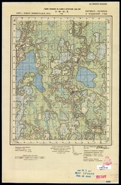
- Description:
- 1937
- Subject:
- Topical Subject: Maps, Topical Subject: Soviet Union, and Geographic Subject: Zenino
- Publisher:
- Главное управление государственной съемки и картографии НКВД СССР
- Language:
- Russian
- Identifier:
- VAC9619-003012
- Genre:
- Military Maps and Topographic Maps
- Geographic Location:
- Coordinates: 59.333, 31.5, 59.5, 31.75
- Related URL:
- Download GeoTIFF: https://drive.google.com/file/d/1jQcCmrOddHVgk6gEwdGWG0-JCsxASGdI/view?usp=sharing and Catalog URL: http://iucat.iu.edu/catalog/5020131
- Abstract:
- Modern area represented: Zenino, Leningrad oblast, Russia
- Call Number:
- G7000 s50 .S68 sheet O-36-16-C
- Caption:
- Для служебного пользования
- City:
- Зенино (Zenino)
- Copyright Holder:
- No Copyright - United States
- Country:
- СССР (USSR)
- State/Province:
- Киришский район (Kirishsky district), РСФСР (RSFSR), Чудовский район (Chudovsky district), Ленинградская область (Leningrad oblast), and Тосненский район (To...
- Physical Description:
- Scale: 1:50,000
- Persistent URL:
- http://purl.dlib.indiana.edu/iudl/images/VAC9619/VAC9619-003012
- Provenance:
- M. I. Map Library, Atlasblatt
