
Search Constraints
You searched for:
Subject
Geographic Subject: Monroe County (Ind.)
Remove constraint Subject: Geographic Subject: Monroe County (Ind.)
Search Results
-
- Subject:
- Geographic Subject: Jackson County (Ind.), Geographic Subject: Lawrence County (Ind.), Geographic Subject: Washington County (Ind.), and Geographic Subject: ...
- Creator:
- Geological Survey (U.S.) and Kilmartin, J. O. (Jerome O'Farrell), 1900-1979
- Publisher:
- Geological Survey (U.S.)
- Date Created:
- 1937
- Identifier:
- VAC3073-M-01314
- Genre:
- Topographic maps, Quadrangle maps, and 15 minute topographic maps
- Geographic Location:
- Coordinates: W0863000 W0861500 N0390000 N0384500
- Related URL:
- Catalog URL: https://iucat.iu.edu/catalog/18408529
- Abstract:
- Topography by J. O. Kilmartin, Shirley Waggener, W. H. Austin, G. G. Martin, and C. W. Birdseye. Polyconic projection. Relief shown by contours and spot heig...
- Call Number:
- G4090 s62 .G4 Bedford 1937
- Caption:
- Imprint: Washington, D.C. : U.S. Dept. of the Interior, Geological Survey, 1937.
- Physical Description:
- Scale: 1:62,500 and Dimensions: 45 x 42 cm or smaller
- Alternate Identifier:
- Title Control Number: a18408529
- Persistent URL:
- https://purl.dlib.indiana.edu/iudl/images/VAC3073/VAC3073-M-01314
- Provenance:
- Part of Geological Survey (U.S.). Indiana 1:62,500.
-
![Indiana Oolitic quadrangle : 15-minute series [1960 reprint with vegetation]](https://iiif.uits.iu.edu/iiif/2/4m90fx888%2Ffiles%2F4b646387-592f-4982-b7bc-aaf89844fb82/full/250,/0/default.jpg)
- Subject:
- Geographic Subject: Lawrence County (Ind.), Geographic Subject: Greene County (Ind.), Topical Subject: Vegetation mapping, Geographic Subject: Martin County ...
- Creator:
- McKinley, W. K. (William Klett), 1891-1964 and Geological Survey (U.S.)
- Publisher:
- Geological Survey (U.S.)
- Date Created:
- 1960
- Identifier:
- VAC3073-M-01297
- Genre:
- 15 minute topographic maps, Quadrangle maps, and Topographic maps
- Geographic Location:
- Coordinates: W0864500 W0863000 N0390000 N0384500
- Related URL:
- Catalog URL: https://iucat.iu.edu/catalog/18413831
- Abstract:
- Topography by W.K. McKinley [and seven others]. Polyconic projection. Relief shown by contours and spot heights. Contour interval 20 feet. Shows portion of L...
- Call Number:
- G4090 s62 .G4 Oolitic
- Caption:
- Imprint: Washington, D.C. : Interior--Geological Survey, 1960
- Physical Description:
- Dimensions: 45 x 42 cm or smaller and Scale: 1:62,500
- Alternate Identifier:
- Title Control Number: a18413831
- Persistent URL:
- https://purl.dlib.indiana.edu/iudl/images/VAC3073/VAC3073-M-01297
- Provenance:
- Part of Geological Survey (U.S.). Indiana 1:62,500.
-
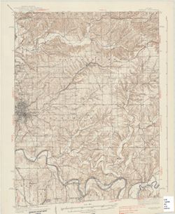
![Indiana Bloomington quadrangle [1946 reprint]](https://iiif.uits.iu.edu/iiif/2/qj72qc04t%2Ffiles%2F069e9c1e-7c2e-4931-8df9-5ba99812cae2/full/250,/0/default.jpg)
- Subject:
- Geographic Subject: Monroe County (Ind.), Geographic Subject: Owen County (Ind.), and Geographic Subject: Greene County (Ind.)
- Creator:
- Griffin, W. H. (William H.), Marshall, R. B. (Robert Bradford), 1867-1949, Herron, W. H. (William Harrison), 1865-, and Sadler, C. L.
- Publisher:
- Geological Survey (U.S.)
- Date Created:
- 1946
- Identifier:
- VAC3073-M-01295
- Genre:
- 15 minute topographic maps, Topographic maps, and Quadrangle maps
- Geographic Location:
- Coordinates: W0864500 W0863000 N0391500 N0390000
- Related URL:
- Catalog URL: https://iucat.iu.edu/catalog/18406221
- Abstract:
- R. B. Marshall, chief geographer , W. H. Herron, Geographer in charge , topography by W. H. Griffin and C. L. Sandler , Control by J. R. Ellis and C. H. Semp...
- Call Number:
- G4090 s62 .G4 Bloomington 1910 R1946
- Caption:
- Imprint: [Washington, D.C.] : United States, Department of the Interior, Geological Survey, [1946]
- Physical Description:
- Scale: 1:62,500 and Dimensions: 45 x 42 cm or smaller
- Alternate Identifier:
- Title Control Number: a18406221
- Persistent URL:
- https://purl.dlib.indiana.edu/iudl/images/VAC3073/VAC3073-M-01295
- Provenance:
- Part of Geological Survey (U.S.). Indiana 1:62,500.
-
![Indiana Bloomington quadrangle [1931 reprint]](https://iiif.uits.iu.edu/iiif/2/k356b6534%2Ffiles%2F0825088b-bc9a-4258-b21f-7c4300529747/full/250,/0/default.jpg)
- Subject:
- Geographic Subject: Greene County (Ind.), Geographic Subject: Owen County (Ind.), and Geographic Subject: Monroe County (Ind.)
- Creator:
- Sadler, C. L., Herron, W. H. (William Harrison), 1865-, Griffin, W. H. (William H.), and Marshall, R. B. (Robert Bradford), 1867-1949
- Publisher:
- Geological Survey (U.S.)
- Date Created:
- 1931
- Identifier:
- VAC3073-M-01294
- Genre:
- Quadrangle maps, 15 minute topographic maps, and Topographic maps
- Geographic Location:
- Coordinates: W0864500 W0863000 N0391500 N0390000
- Related URL:
- Catalog URL: https://iucat.iu.edu/catalog/18406221
- Abstract:
- R. B. Marshall, chief geographer , W. H. Herron, Geographer in charge , topography by W. H. Griffin and C. L. Sandler , Control by J. R. Ellis and C. H. Semp...
- Call Number:
- G4090 s62 .G4 Bloomington 1910 R1931
- Caption:
- Imprint: [Washington, D.C.] : United States, Department of the Interior, Geological Survey, [1931]
- Physical Description:
- Scale: 1:62,500 and Dimensions: 45 x 42 cm or smaller
- Alternate Identifier:
- Title Control Number: a18406221
- Persistent URL:
- https://purl.dlib.indiana.edu/iudl/images/VAC3073/VAC3073-M-01294
- Provenance:
- Part of Geological Survey (U.S.). Indiana 1:62,500.
-
- Subject:
- Geographic Subject: Monroe County (Ind.), Geographic Subject: Indiana, Geographic Subject: Brown County (Ind.), Topical Subject: Glaciology, Topical Subject:...
- Creator:
- Pratt, Alan (Geologist)
- Date Created:
- 1960
- Identifier:
- VAC3073-M-01259
- Genre:
- Geological maps
- Geographic Location:
- Coordinates: W0864107 W0860733 N0392122 N0391123
- Related URL:
- Catalog URL: https://iucat.iu.edu/catalog/18455593
- Abstract:
- Relief shown by spot heights. Includes index map. Shows sediments by glacial epoch as well as recent alluvium and colluvium deposits and Meramecian and Osagi...
- Call Number:
- G4093.M7C5 1958 .P7
- Caption:
- Imprint: [Bloomington, Indiana?] : [Alan Pratt], 1960.
- Physical Description:
- Dimensions: 32 x 77 cm, on sheet 52 x 82 cm and Scale: 1:63,360
- Alternate Identifier:
- Title Control Number: a18455593
- Persistent URL:
- https://purl.dlib.indiana.edu/iudl/images/VAC3073/VAC3073-M-01259
- Provenance:
- The geomorphology and geomorphic history of Bean Blossom Valley, Monroe and Brown Counties, Indiana / Alan R. Pratt. Thesis (A.M.)--Indiana University, 1960.
-
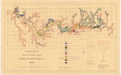
- Subject:
- Geographic Subject: Monroe County (Ind.) and Topical Subject: Soils
- Creator:
- Shannon, C. W. (Charles William), 1879-1934
- Publisher:
- Indiana. Department of Geology and Natural Resources
- Date Created:
- 1908
- Identifier:
- VAC3073-M-01241
- Genre:
- Thematic maps
- Geographic Location:
- Coordinates: W0864108 W0861902 N0392120 N0385926
- Related URL:
- Catalog URL: https://iucat.iu.edu/catalog/16136315
- Abstract:
- Shows roads, earth and improved, railroads, school houses, and churches. Detached from: Soil survey of Monroe, Brown, Lawrence, Martin, Orange, Washington...
- Call Number:
- G4093.M7J3 1907 .S5
- Caption:
- Imprint: [Indianapolis] : [Indiana Department of Geology and Natural Resources], [1908]
- Physical Description:
- Dimensions: 66 x 52 cm and Scale: Approximately 1:63,360
- Alternate Identifier:
- Title Control Number: a16136315 and Alternate ID: 390726IP
- Persistent URL:
- https://purl.dlib.indiana.edu/iudl/images/VAC3073/VAC3073-M-01241
- Provenance:
- 32nd Annual Report (1907) / Indiana. Department of Geology and Natural Resources.
-
![Indiana Bloomington quadrangle [1948 reprint]](https://iiif.uits.iu.edu/iiif/2/2j62t788s%2Ffiles%2F57d817cb-ee47-4ed5-9f38-24d8a93dcb0b/full/250,/0/default.jpg)
- Subject:
- Geographic Subject: Owen County (Ind.), Geographic Subject: Greene County (Ind.), and Geographic Subject: Monroe County (Ind.)
- Creator:
- Marshall, R. B. (Robert Bradford), 1867-1949, Herron, W. H. (William Harrison), 1865-, Griffin, W. H. (William H.), and Sadler, C. L.
- Publisher:
- Geological Survey (U.S.)
- Date Created:
- 1948
- Identifier:
- VAC3073-M-01219
- Genre:
- Topographic maps, 15 minute topographic maps, and Quadrangle maps
- Geographic Location:
- Coordinates: W0880000 W0844500 N0414500 N0375200
- Related URL:
- Catalog URL: https://iucat.iu.edu/catalog/18406221
- Abstract:
- R. B. Marshall, chief geographer , W. H. Herron, Geographer in charge , topography by W. H. Griffin and C. L. Sandler , Control by J. R. Ellis and C. H. Semp...
- Call Number:
- G4090 s62 .G4 Bloomington 1910 R1948
- Caption:
- Imprint: [Washington, D.C.] : United States, Department of the Interior, Geological Survey, [1948]
- Physical Description:
- Dimensions: 45 x 42 cm or smaller and Scale: 1:62,500
- Alternate Identifier:
- Title Control Number: a18406221
- Persistent URL:
- https://purl.dlib.indiana.edu/iudl/images/VAC3073/VAC3073-M-01219
- Provenance:
- Part of Geological Survey (U.S.). Indiana 1:62,500.
-
![Indiana Bloomington quadrangle [1946 reprint with 21 indexed cave locations]](https://iiif.uits.iu.edu/iiif/2/dz011t645%2Ffiles%2Fbb3033b6-3144-4af2-a6c7-a5710771ff06/full/250,/0/default.jpg)
- Subject:
- Geographic Subject: Owen County (Ind.), Geographic Subject: Monroe County (Ind.), Topical Subject: Caves, and Geographic Subject: Greene County (Ind.)
- Creator:
- Griffin, W. H. (William H.), Marshall, R. B. (Robert Bradford), 1867-1949, Sadler, C. L., and Herron, W. H. (William Harrison), 1865-
- Publisher:
- Geological Survey (U.S.)
- Date Created:
- 1946
- Identifier:
- VAC3073-M-01218
- Genre:
- Topographic maps, Quadrangle maps, and 15 minute topographic maps
- Geographic Location:
- Coordinates: W0864500 W0863000 N0391500 N0390000
- Related URL:
- Catalog URL: https://iucat.iu.edu/catalog/18406221
- Abstract:
- R. B. Marshall, chief geographer , W. H. Herron, Geographer in charge , topography by W. H. Griffin and C. L. Sandler , Control by J. R. Ellis and C. H. Semp...
- Call Number:
- G4090 s62 .G4 Bloomington 1910 R1946
- Caption:
- Imprint: [Washington, D.C.] : United States, Department of the Interior, Geological Survey, [1946]
- Physical Description:
- Scale: 1:62,500 and Dimensions: 45 x 42 cm or smaller
- Alternate Identifier:
- Title Control Number: a18406221
- Persistent URL:
- https://purl.dlib.indiana.edu/iudl/images/VAC3073/VAC3073-M-01218
- Provenance:
- Part of Geological Survey (U.S.). Indiana 1:62,500.
-
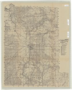
- Subject:
- Geographic Subject: Monroe County (Ind.)
- Creator:
- Siebenthal, C. E. (Claude Ellsworth), 1869-1930
- Publisher:
- Julius Bien & Co.
- Date Created:
- 1895
- Identifier:
- VAC3073-M-01197
- Genre:
- Maps
- Related URL:
- Catalog URL: https://iucat.iu.edu/catalog/5101345
- Abstract:
- Sheets included NE sheet, NW sheet, SE sheet, SW sheet Glossy photograph on Kodak paper. Reproduction of a printed map. Reproduced by John Robbins, a f...
- Call Number:
- G4093.M7 1895 .S543 NE sheet
- Physical Description:
- Dimensions: 81 x 64 cm, on sheets 51 x 41 cm and Scale: Approximately 1:52,000
- Persistent URL:
- https://purl.dlib.indiana.edu/iudl/images/VAC3073/VAC3073-M-01197
-
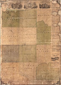
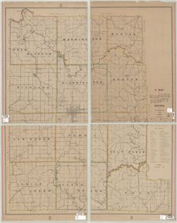
- Subject:
- Topical Subject: Real property, Geographic Subject: Monroe County (Ind.), and Topical Subject: Landowners
- Creator:
- Davis, R. S. (Surveyor)
- Publisher:
- Davis & Kennedy
- Date Created:
- 1856
- Identifier:
- VAC3073-M-01195
- Genre:
- Cadastral maps
- Geographic Location:
- Coordinates: W0864108 W0861902 N0392120 N0385926
- Related URL:
- Catalog URL: https://iucat.iu.edu/catalog/14846059
- Abstract:
- Includes "Statistics for Monroe County for 1856", advertisements, and views of the county courthouse, Indiana University, and the home of Bloomingt...
- Call Number:
- G4093.M7G46 1856 .D38
- Caption:
- Imprint: [Columbus, Indiana] : Davis & Kennedy, 1856 and Imprint: Louisville, Ky. : Robyn & Co. Lithog., [1856]
- Physical Description:
- Scale: Scale not given.
- Persistent URL:
- https://purl.dlib.indiana.edu/iudl/images/VAC3073/VAC3073-M-01195
