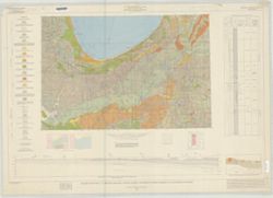
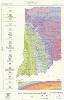
By Allan F. Schneider and Stanley J. Keller. Transverse Mercator projection. "Indiana Geological Survey in cooperation with Illinois State Geological Su...
Gray, Henry Hamilton, 1922-, Wier, Charles E. (Charles Eugene), 1921-, Indiana. Geological Survey, Wayne, William J. (William John), 1922-, and Illinois Stat...
Publisher:
Indiana. Geological Survey
Date Created:
1970
Identifier:
VAC3073-M-01257
Genre:
Quadrangle maps, Geological maps, and Geological cross-sections
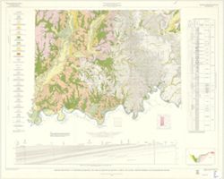
By Henry H. Gray, William J. Wayne, and Charles E. Wier , Indiana Geological Survey, in cooperation with Illinois State Geological Survey. Transverse Mercato...
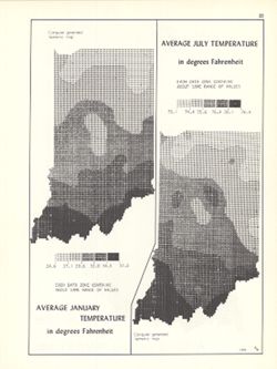
2 maps on 1 sheet, Average January temperature in degrees Fahrenheit and Average July temperature in degrees Fahrenheit. Computer generated isometric maps ob...
Call Number:
G4091.C82 1970 .K57
Caption:
Imprint: Bloomington, Indiana : Department of Geography, Indiana University, [1970]
Physical Description:
Dimensions: each 26 x 10 cm, on sheet 28 x 21 cm and Scale: Approximately 1:3,000,000
Alternate Identifier:
Title Control Number: a15995455 and Alternate ID: 317383IP
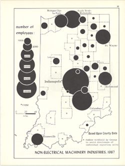
Graduated symbol map. Shows number of employees by county. Detached from: An atlas of Indiana / by Robert C. Kingsbury , with contributions from John M. H...
Call Number:
G4091.G8 1967 .K6
Caption:
Imprint: Bloomington, Indiana : Department of Geography, Indiana University, [1970]
Physical Description:
Dimensions: 26 x 18 cm, on sheet 28 x 21 cm and Scale: Approximately 1:1,950,000
Alternate Identifier:
Title Control Number: a15951271 and Alternate ID: 317383IP
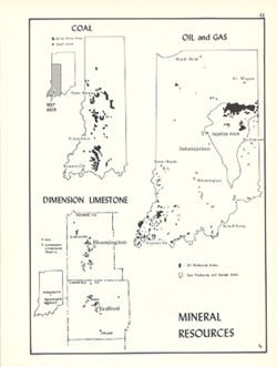
Shows oil and gas producing areas, strip mine areas and shaft mines extracting coal, and dimension limestone quarries and mills. Includes 2 ancillary maps an...
Call Number:
G4091.M2 1970 .K56
Caption:
Imprint: Bloomington, Indiana : Department of Geography, Indiana University, [1970]
Physical Description:
Scale: Approximately 1:3,000,000 and Dimensions: 26 x 18 cm, on sheet 28 x 21 cm
Alternate Identifier:
Title Control Number: a15954747 and Alternate ID: 317383IP
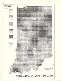
Computer generated isopleth map obtained through use of the facilities of Indiana University's Research Computer Center. ASCII-art map created using SYMA...
Call Number:
G4091.E2 1960 .K55
Caption:
Imprint: Bloomington, Indiana : Department of Geography, Indiana University, [1970]
Physical Description:
Scale: Approximately 1:1,950,000 and Dimensions: 26 x 18 cm, on sheet 28 x 21 cm
Alternate Identifier:
Title Control Number: a15946819 and Alternate ID: 317383IP
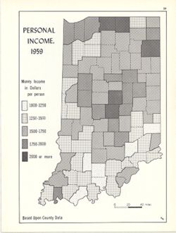
Choropleth map. Shows average income per person by county. Detached from: An atlas of Indiana / by Robert C. Kingsbury , with contributions from John M. H...
Call Number:
G4091.E74 1959 .K56
Caption:
Imprint: Bloomington, Indiana : Department of Geography, Indiana University, [1970]
Physical Description:
Dimensions: 26 x 18 cm, on sheet 28 x 21 cm and Scale: Approximately 1:2,000,000
Alternate Identifier:
Title Control Number: a15947804 and Alternate ID: 317383IP
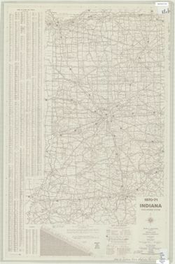
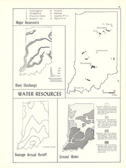
4 maps on 1 sheet, River discharge, Major reservoirs, Average annual runoff and Ground water. Includes index for Major reservoirs map. Detached from: An a...
Call Number:
G1400 .K53 1970
Caption:
Imprint: Bloomington, Indiana : Department of Geography, Indiana University, [1970]
Physical Description:
Scale: Approximately 1:3,500,000 and Dimensions: on sheet 28 x 21 cm
Alternate Identifier:
Alternate ID: 317383IP and Title Control Number: a15941579