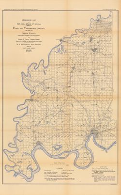
Relief shown by spot heights. "Based upon[:] B. F. & Co.'s Atlas of Indiana, 1876. Lake's Atlas of Gibson and Pike Counties, 1881. F. C. H. ...
Call Number:
QE109 .A2 1898 map p1408
Caption:
Imprint: Indianapolis, Ind. : Wm. B. Burford, [1899]
Physical Description:
Scale: Approximately 1:126,720. 2 miles = 1 inch and Dimensions: 78 x 48 cm
Alternate Identifier:
Title Control Number: a18188198 and Alternate ID: 390726IP
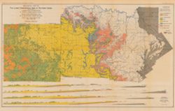
Includes 4 East-West cross-sections through the center of townships 1, 2 and 3 North and 1 South. Vertical scale 1:9,600. Detached from: The geology of th...
Call Number:
G4091.C5 1902 .A82
Caption:
Imprint: [Indianapolis] : Department of Geology and Natural Resources of Indiana, [1903] and Imprint: Indianapolis, Ind. : Wm. B. Burford, [1903]
Physical Description:
Dimensions: 46 x 74 cm, on sheet 50 x 78 cm and Scale: Approximately 1:126,720. 2 miles = 1 in. Vertical scale approximately 1:9,600. 800 feet = 1 in.
Alternate Identifier:
Title Control Number: a16076838 and Alternate ID: 390726IP
Geographic Subject: Scott County (Ind.), Geographic Subject: Harrison County (Ind.), Topical Subject: Geology, Topical Subject: IGS Annual Reports, Geographi...
Publisher:
Indiana. Department of Geology and Natural Resources
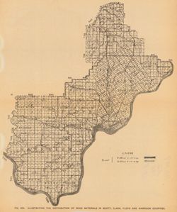
Shows gravel locations. At head of title: Fig. 49A. Detached from: The roads and road materials of a portion of southwestern Indiana / A.E. Taylor. In Ind...
Call Number:
G4093.S3H5 1905 .I4
Caption:
Imprint: [Indianapolis] : [Indiana Dept. of Geology and Natural Resources], [1906]
Physical Description:
Scale: Approximately 1:371,000 and Dimensions: on sheet 27 x 23 cm
Alternate Identifier:
Alternate ID: 390726IP and Title Control Number: a18299034
Title from caption. Other title from Bureau of Land Management database: IN T5S R8W. 16 columnar sections showing coal measures and location map for unnamed ...
Call Number:
G4093.W4H9 1898 .T6
Caption:
Imprint: [Indianapolis] : [Wm. B. Burford], [1899] and Imprint: [Indianapolis] : [Indiana, Dept. of Geology and Natural History], [1899]
Physical Description:
Dimensions: 23 x 27 cm and Scale: Approximately 1:63,360
Alternate Identifier:
Alternate ID: 390726IP and Title Control Number: a18418184
Detached from: The lakes of northern Indiana and their associated marl deposits / W. S. Blatchley and Geo. H. Ashley. In Indiana Department of Geology and N...
Call Number:
G4093.S7 1899 .R35
Caption:
Imprint: (c)1899, Imprint: [Indianapolis] : [Indiana. Department of Geology and Natural Resources], [1901], and Imprint: [Indianapolis] : [Wm. B. Burford], [...
Physical Description:
Dimensions: on sheet 22 x 26 cm and Scale: Approximately 1:135,000
Alternate Identifier:
Title Control Number: a18276218 and Alternate ID: 390726IP
Relief shown by spot heights. Includes map showing coal locations and features, railroads, and quarries as well as vertical cross sections for Dana to Portla...
Call Number:
G4093.V5H9 1898 .A84
Caption:
Imprint: Indianapolis, Ind. : Wm. B. Burford, [1899]
Physical Description:
Scale: Approximately 1:126,720. 2 miles = 1 inch and Dimensions: 48 x 77 cm
Alternate Identifier:
Alternate ID: 390726IP and Title Control Number: a18259650
Detached from: The iron ore deposits of Indiana / Charles W. Shannon. In Indiana Dept. of Geology and Natural Resources thirty-first annual report, 1906. Ind...
Call Number:
G4093.M5H2 1907 .M3
Caption:
Imprint: [Indianapolis] : [Indiana Dept. of Geology and Natural Resources], [1907] and Imprint: [Indianapolis] : [Wm. B. Burford], [1907]
Physical Description:
Scale: Approximately 1:59,000 and Dimensions: on sheet 27 x 37 cm
Alternate Identifier:
Alternate ID: 390726IP and Title Control Number: a18299172
"NOTE - The eastern outcrop of the Knobstone is from map by Ind. Univ. Geol. Surv. Eastern outcrop of Devonian surveyed by J. A. Price. Eastern outcrop ...
Call Number:
G4091.H5 1900 .S54
Caption:
Imprint: Indianapolis, Ind. : Wm. B. Burford, Lith., [1901]
Physical Description:
Scale: Approximately 1:126,720. 2 miles = 1 inch and Dimensions: 47 x 38 cm
Alternate Identifier:
Title Control Number: a18188442 and Alternate ID: 390726IP
3 sections on one sheet. Title from caption. Shows strategraphic measurements for sections 5.9A, 1.38A, and 1.38B. Detached from: The stratigraphy and pal...
Call Number:
G4091.C57 1907 .Z47
Caption:
Imprint: [Indianapolis] : [Indiana Department of Geology and Natural Resources], [1908]
Physical Description:
Dimensions: 44 x 19 cm
Alternate Identifier:
Title Control Number: a18307667 and Alternate ID: 390726IP

![Township 5 south, range 8 west [Indiana]](https://iiif.uits.iu.edu/iiif/2/df65wb20n%2Ffiles%2F076a45f7-4ea5-41d9-9a65-3d0fbf136b54/full/250,/0/default.jpg)