
Search Constraints
You searched for:
Campus
IUB
Remove constraint Campus: IUB
Creator
Goodlove, C. W.
Remove constraint Creator: Goodlove, C. W.
Holding Location
B-WELLS
Remove constraint Holding Location: B-WELLS
Pages
0-99 pages
Remove constraint Pages: 0-99 pages
Publisher
Geological Survey (U.S.)
Remove constraint Publisher: Geological Survey (U.S.)
« Previous |
1 - 10 of 31
|
Next »
Search Results
-
![Indiana Velpen quadrangle [1903 printing]](https://iiif.uits.iu.edu/iiif/2/70796d46b%2Ffiles%2F57edc4e0-ddd1-4ff6-ab07-25dd93b93b50/full/250,/0/default.jpg)
- Subject:
- Geographic Subject: Dubois County (Ind.) and Geographic Subject: Pike County (Ind.)
- Creator:
- Geological Survey (U.S.), Renshawe, John H., Goodlove, C. W., and Hawkins, Geo. T. (George T.)
- Publisher:
- Geological Survey (U.S.)
- Date Created:
- 1903
- Identifier:
- VAC3073-M-01309
- Genre:
- 15 minute topographic maps, Quadrangle maps, and Topographic maps
- Geographic Location:
- Coordinates: W0871500 W0870000 N0383000 N0381500
- Related URL:
- Catalog URL: https://iucat.iu.edu/catalog/18415495
- Abstract:
- Jno. H. Renshawe, geographer in charge , control by Geo. T. Hawkins , topography by Chas. W. Goodlove , engraved Oct. 1902 by U.S.G.S. Edition of Feb. 1903. ...
- Call Number:
- G4090 s62 .G4 Velpen 1903
- Caption:
- Imprint: Washington, D.C. : U.S. Geological Survey, [1903]
- Physical Description:
- Scale: 1:62,500 and Dimensions: 45 x 42 cm or smaller
- Alternate Identifier:
- Title Control Number: a18415495
- Persistent URL:
- https://purl.dlib.indiana.edu/iudl/images/VAC3073/VAC3073-M-01309
- Provenance:
- Part of Geological Survey (U.S.). Indiana 1:62,500.
-
![Kentucky-Indiana Henderson quadrangle [1947 reprint]](https://iiif.uits.iu.edu/iiif/2/8g84nq007%2Ffiles%2F1905d7bd-1124-4f85-864e-258fad082d25/full/250,/0/default.jpg)
- Subject:
- Geographic Subject: Hendricks County (Ind.), Geographic Subject: Posey County (Ind.), and Geographic Subject: Vanderburgh County (Ind.)
- Creator:
- Kentucky Geological Survey, United States. Army, Herrington, R. M. (Russell McKee), 1890-1977, Goodlove, C. W., Gehres, W. S. (Wilmer Sherman), 1887-1963, Ge...
- Publisher:
- Geological Survey (U.S.)
- Date Created:
- 1947
- Identifier:
- VAC3073-M-01344
- Genre:
- 15 minute topographic maps, Quadrangle maps, and Topographic maps
- Geographic Location:
- Coordinates: W0874500 W0873000 N0380000 N0374500
- Related URL:
- Catalog URL: https://iucat.iu.edu/catalog/18408409
- Abstract:
- Filing title: Henderson, Ky.-Ind. Edition of 1916. Relief shown by contours and spot heights. Shows Henderson and Vandergurgh counties in Kentucky and Posey ...
- Call Number:
- G4090 s62 .G4 1916 rep 1947
- Caption:
- Imprint: [Washington, D.C.] : Department of the Interior, U.S. Geological Survey, [1947]
- Physical Description:
- Dimensions: 45 x 42 cm or smaller and Scale: 1:62,500
- Alternate Identifier:
- Title Control Number: a18408409
- Persistent URL:
- https://purl.dlib.indiana.edu/iudl/images/VAC3073/VAC3073-M-01344
- Provenance:
- Part of Geological Survey (U.S.). Indiana 1:62,500.
-
![Indiana Degonia Springs quadrangle [1936 reprint]](https://iiif.uits.iu.edu/iiif/2/x346f640t%2Ffiles%2F0b272452-2a1a-4415-897a-e57e4a8c1f70/full/250,/0/default.jpg)
- Subject:
- Geographic Subject: Warrick County (Ind.), Geographic Subject: Dubois County (Ind.), Geographic Subject: Spencer County (Ind.), and Geographic Subject: Pike ...
- Creator:
- Renshawe, John H., Goodlove, C. W., Geological Survey (U.S.), and Hawkins, Geo. T. (George T.)
- Publisher:
- Geological Survey (U.S.)
- Date Created:
- 1936
- Identifier:
- VAC3073-M-01293
- Genre:
- 15 minute topographic maps, Topographic maps, and Quadrangle maps
- Geographic Location:
- Coordinates: W0871500 W0870000 N0381500 N0380000
- Related URL:
- Catalog URL: https://iucat.iu.edu/catalog/18408290
- Abstract:
- Engraved Oct. 1902 by U.S.G.S. , Jno. Renshawe, geographer in charge , control by Geo. T. Hawkins , topography by Chas. W. Goodlove. Filing title: Degonia Sp...
- Call Number:
- G4090 s62 .G4 Degonia Springs 1902 rep1936
- Caption:
- Imprint: [Washington, D.C.] : U.S. Geological Survey, 1936
- Physical Description:
- Scale: 1:62,500 and Dimensions: 45 x 42 cm or smaller
- Alternate Identifier:
- Title Control Number: a18408290
- Persistent URL:
- https://purl.dlib.indiana.edu/iudl/images/VAC3073/VAC3073-M-01293
- Provenance:
- Part of Geological Survey (U.S.). Indiana 1:62,500.
-
![Indiana Haubstadt quadrangle [1903 printing]](https://iiif.uits.iu.edu/iiif/2/mw22w891g%2Ffiles%2F3f2a82be-5754-4703-989d-ede2f3a3b596/full/250,/0/default.jpg)
- Subject:
- Geographic Subject: Posey County (Ind.), Geographic Subject: Gibson County (Ind.), and Geographic Subject: Vanderburgh County (Ind.)
- Creator:
- Renshawe, John H., Goodlove, C. W., Hawkins, Geo. T. (George T.), and Geological Survey (U.S.)
- Publisher:
- Geological Survey (U.S.)
- Date Created:
- 1903
- Identifier:
- VAC3073-M-01342
- Genre:
- Quadrangle maps, 15 minute topographic maps, and Topographic maps
- Geographic Location:
- Coordinates: W0874500 W0873000 N0381500 N0380000
- Related URL:
- Catalog URL: https://iucat.iu.edu/catalog/18408287
- Abstract:
- Engraved Mar. 1903 by U.S.G.S. , Jno. H. Renshawe, geographer in charge , control by Geo. T. Hawkins , topography by Chas. W. Goodlove. Relief shown by conto...
- Call Number:
- G4090 s62 .G4 Haubstadt 1903
- Caption:
- Imprint: [Washington, D.C.] : U.S. Geological Survey, 1903
- Physical Description:
- Dimensions: 45 x 42 cm or smaller and Scale: 1:62,500
- Alternate Identifier:
- Title Control Number: a18408287
- Persistent URL:
- https://purl.dlib.indiana.edu/iudl/images/VAC3073/VAC3073-M-01342
- Provenance:
- Part of Geological Survey (U.S.). Indiana 1:62,500.
-
![Indiana-Illinois Patoka quadrangle [1903 print]](https://iiif.uits.iu.edu/iiif/2/697004346%2Ffiles%2Fa8ce9ba2-6345-47f5-8aa5-e6adddaad8fd/full/250,/0/default.jpg)
- Subject:
- Geographic Subject: White County (Ill.), Geographic Subject: Edwards County (Ill.), Geographic Subject: Knox County (Ind.), Geographic Subject: Posey County ...
- Creator:
- Goodlove, C. W., Hawkins, Geo. T. (George T.), Geological Survey (U.S.), and Renshawe, John H.
- Publisher:
- Geological Survey (U.S.)
- Date Created:
- 1903
- Identifier:
- VAC3073-M-01418
- Genre:
- 30 minute topographic maps, Quadrangle maps, and Topographic maps
- Geographic Location:
- Coordinates: W0880000 W0873000 N0383000 N0380000
- Related URL:
- Catalog URL: https://iucat.iu.edu/catalog/18416043
- Abstract:
- Jno. H. Renshawe, geographer in charge , control by Geo. T. Hawkins , topography by Chas. W. Goodlove , engraved June 1903 by U.S.G.S. Relief shown by contou...
- Call Number:
- G4090 s125 .G4 Patoka 1903
- Caption:
- Imprint: [Washington, D.C.] : U.S. Geological Survey, [1903]
- Physical Description:
- Dimensions: 45 x 36 cm and Scale: 1:125,000
- Alternate Identifier:
- Title Control Number: a18416043
- Persistent URL:
- https://purl.dlib.indiana.edu/iudl/images/VAC3073/VAC3073-M-01418
- Provenance:
- Part of Geological Survey (U.S.). Indiana 1:125,000.
-
![Indiana St. Meinrad quadrangle [1903 printing]](https://iiif.uits.iu.edu/iiif/2/nk323h76c%2Ffiles%2Fe917d3f1-9cbd-4705-9a9a-2617f0dbde44/full/250,/0/default.jpg)
- Subject:
- Geographic Subject: Perry County (Ind.), Geographic Subject: Dubois County (Ind.), and Geographic Subject: Spencer County (Ind.)
- Creator:
- Goodlove, C. W., Renshawe, John H., Hawkins, Geo. T. (George T.), and Geological Survey (U.S.)
- Publisher:
- Geological Survey (U.S.)
- Date Created:
- 1903
- Identifier:
- VAC3073-M-01392
- Genre:
- Quadrangle maps, Topographic maps, and 15 minute topographic maps
- Geographic Location:
- Coordinates: W0870000 W0864500 N0381500 N0380000
- Related URL:
- Catalog URL: https://iucat.iu.edu/catalog/18413973
- Abstract:
- Jno. H. Renshawe, geographer in charge , control by Geo. T. Hawkins , topography by Chas. W. Goodlove , engraved Jan. 1903 by U.S.G.S. Edition of 1903. Poly...
- Call Number:
- G4090 s62 .G4 St. Meinrad 1903
- Caption:
- Imprint: Washington, D.C. : U.S. Geological Survey, 1903
- Physical Description:
- Dimensions: 45 x 42 cm or smaller and Scale: 1:62,500
- Alternate Identifier:
- Title Control Number: a18413973
- Persistent URL:
- https://purl.dlib.indiana.edu/iudl/images/VAC3073/VAC3073-M-01392
- Provenance:
- Part of Geological Survey (U.S.). Indiana 1:62,500.
-
![Indiana Velpen quadrangle [1936 reprint]](https://iiif.uits.iu.edu/iiif/2/z316r503r%2Ffiles%2Fff5fa112-3598-4f96-a57d-5bd5fcb23db6/full/250,/0/default.jpg)
- Subject:
- Geographic Subject: Pike County (Ind.) and Geographic Subject: Dubois County (Ind.)
- Creator:
- Goodlove, C. W., Hawkins, Geo. T. (George T.), and Geological Survey (U.S.)
- Publisher:
- Geological Survey (U.S.)
- Date Created:
- 1936
- Identifier:
- VAC3073-M-01408
- Genre:
- 15 minute topographic maps, Quadrangle maps, and Topographic maps
- Geographic Location:
- Coordinates: W0871500 W0870000 N0383000 N0381500
- Related URL:
- Catalog URL: https://iucat.iu.edu/catalog/18415495
- Abstract:
- Jno. H. Renshawe, geographer in charge , control by Geo. T. Hawkins , topography by Chas. W. Goodlove , engraved Oct. 1902 by U.S.G.S. Polyconic projectio...
- Call Number:
- G4093.P4C5 1900 .G4
- Caption:
- Imprint: Washington, D.C. : U.S. Geological Survey, [1903]
- Physical Description:
- Dimensions: 45 x 42 cm or smaller and Scale: 1:62,500
- Alternate Identifier:
- Title Control Number: a18415495
- Persistent URL:
- https://purl.dlib.indiana.edu/iudl/images/VAC3073/VAC3073-M-01408
- Provenance:
- Part of Geological Survey (U.S.). Indiana 1:62,500.
-
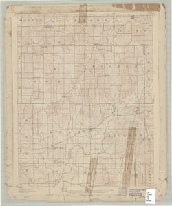
- Subject:
- Geographic Subject: Spencer County (Ind.), Geographic Subject: Dubois County (Ind.), Geographic Subject: Warrick County (Ind.), and Geographic Subject: Pike ...
- Creator:
- Renshawe, John H., Geological Survey (U.S.), Hawkins, Geo. T. (George T.), and Goodlove, C. W.
- Publisher:
- Geological Survey (U.S.)
- Date Created:
- 1902
- Identifier:
- VAC3073-M-01301
- Genre:
- 15 minute topographic maps, Topographic maps, and Quadrangle maps
- Geographic Location:
- Coordinates: W0871500 W0870000 N0381500 N0380000
- Related URL:
- Catalog URL: https://iucat.iu.edu/catalog/18408290
- Abstract:
- Engraved Oct. 1902 by U.S.G.S. , Jno. Renshawe, geographer in charge , control by Geo. T. Hawkins , topography by Chas. W. Goodlove. Filing title: Degonia Sp...
- Call Number:
- G4090 s62 .G4 Degonia Springs 1902
- Caption:
- Imprint: Washington, D.C. : The Survey, 1902
- Physical Description:
- Dimensions: 45 x 42 cm or smaller and Scale: 1:62,500
- Alternate Identifier:
- Title Control Number: a18408290
- Persistent URL:
- https://purl.dlib.indiana.edu/iudl/images/VAC3073/VAC3073-M-01301
- Provenance:
- Part of Geological Survey (U.S.). Indiana 1:62,500.
-
![Indiana, Ditney quadrangle [1936 reprint]](https://iiif.uits.iu.edu/iiif/2/6108wd72k%2Ffiles%2Fb445f2c6-cbee-44ef-907e-13b38773b333/full/250,/0/default.jpg)
- Subject:
- Geographic Subject: Vanderburgh County (Ind.), Geographic Subject: Pike County (Ind.), Geographic Subject: Warrick County (Ind.), Geographic Subject: Gibson ...
- Creator:
- Geological Survey (U.S.), Renshawe, John H., McKinney, R. C. (Robert C.), Blair, H. B. (Herbert Buxton), 1860-1905, and Goodlove, C. W.
- Publisher:
- Geological Survey (U.S.)
- Date Created:
- 1936
- Identifier:
- VAC3073-M-01417
- Genre:
- Quadrangle maps, Topographic maps, and 30 minute topographic maps
- Geographic Location:
- Coordinates: W0873000 W0870000 N0383000 N0380000
- Related URL:
- Catalog URL: https://iucat.iu.edu/catalog/18416043
- Abstract:
- Indiana, 30 minute series (topographic). Filing title: Ditney, Ind. Jno. H. Renshawe, geographer in charge , topography by H.B. Blair, R.C. McKinney, and Cha...
- Call Number:
- G4090 s125 .G4 Ditney 1902 rep1936
- Caption:
- Imprint: [United States] : Geological Survey, 1936
- Physical Description:
- Scale: 1:125,000 and Dimensions: 45 x 36 cm
- Alternate Identifier:
- Title Control Number: a18416043
- Persistent URL:
- https://purl.dlib.indiana.edu/iudl/images/VAC3073/VAC3073-M-01417
- Provenance:
- Part of Geological Survey (U.S.). Indiana 1:125,000.
-
![Indiana-Illinois, New Harmony quadrangle [1942 reprint without vegetation]](https://iiif.uits.iu.edu/iiif/2/7m01cp450%2Ffiles%2F687ca4a9-29c4-4fc4-88d4-234e6f47aa32/full/250,/0/default.jpg)
- Subject:
- Geographic Subject: Gibson County (Ind.), Geographic Subject: Posey County (Ind.), Geographic Subject: Wabash County (Ill.), and Geographic Subject: White Co...
- Creator:
- Goodlove, C. W., Renshawe, John H., Hawkins, Geo. T. (George T.), and Geological Survey (U.S.)
- Publisher:
- Geological Survey (U.S.)
- Date Created:
- 1942
- Identifier:
- VAC3073-M-01355
- Genre:
- 15 minute topographic maps, Quadrangle maps, and Topographic maps
- Geographic Location:
- Coordinates: W0880000 W0874500 N0381500 N0380000
- Related URL:
- Catalog URL: https://iucat.iu.edu/catalog/18412806
- Abstract:
- John. H. Renshawe, geographer in charge , control by Geo. T. Hawkins , topography by Chas. W. Goodlove , engraved April 1903 by U.S.G.S. Filing title: New Ha...
- Call Number:
- G4090 s62 .G4 New Harmony 1903 rep 1942
- Caption:
- Imprint: [Washington, D.C.] : U.S. Geological Survey, 1942
- Physical Description:
- Scale: 1:62,500 and Dimensions: 45 x 42 cm or smaller
- Alternate Identifier:
- Title Control Number: a18412806
- Persistent URL:
- https://purl.dlib.indiana.edu/iudl/images/VAC3073/VAC3073-M-01355
- Provenance:
- Part of Geological Survey (U.S.). Indiana 1:62,500.

- « Previous
- Next »
- 1
- 2
- 3
- 4