
Search Constraints
You searched for:
Campus
IUB
Remove constraint Campus: IUB
Country
СССР (USSR)
Remove constraint Country: СССР (USSR)
Date Created
1940
Remove constraint Date Created: 1940
Type
Image
Remove constraint Type: Image
Pages
0-99 pages
Remove constraint Pages: 0-99 pages
State
deposited
Remove constraint State: deposited
« Previous |
1 - 50 of 88
|
Next »
Search Results
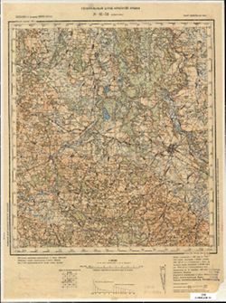
-
- Subject:
- Geographic Subject: Shuvalovo, Topical Subject: Soviet Union, and Topical Subject: Maps
- Publisher:
- Генеральный штаб Красной Армии
- Language:
- Russian
- Date Created:
- 1940
- Identifier:
- VAC9619-002561
- Genre:
- Military Maps and Topographic Maps
- Geographic Location:
- Coordinates: 60, 30, 60.333, 30.5
- Related URL:
- Download GeoTIFF: https://drive.google.com/file/d/1HSE6GiUOtSkJ7_BzusJuDugqPn8Ac_Xu/view?usp=sharing and Catalog URL: https://iucat.iu.edu/catalog/5020129
- Abstract:
- Currently a part of Saint Petersburg, Russia.
- Call Number:
- G7000 s100 .S7 sheet P-36-133
- Caption:
- Для служебного пользования
- City:
- Шувалово-Озерки (Shuvalovo-Ozerki)
- Copyright Holder:
- No Copyright - United States
- Country:
- СССР (USSR)
- State/Province:
- РСФСР (RSFSR) and Ленинградская область (Leningrad oblast)
- Physical Description:
- Scale: 1:100,000
- Persistent URL:
- http://purl.dlib.indiana.edu/iudl/images/VAC9619/VAC9619-002561
- Provenance:
- DMA Topographic Center, Army Map Service Library, OMAHA
-
- Subject:
- Geographic Subject: Kamennogorsk, Topical Subject: Soviet Union, and Topical Subject: Maps
- Publisher:
- Генеральный штаб Красной Армии
- Language:
- Russian
- Date Created:
- 1940
- Identifier:
- VAC9619-002396
- Genre:
- Topographic Maps and Military Maps
- Geographic Location:
- Coordinates: 60.667, 29, 61, 29.5
- Related URL:
- Catalog URL: https://iucat.iu.edu/catalog/5020129 and Download GeoTIFF: https://drive.google.com/file/d/1qwxTvuQqhw-LhbzC_Qa27F8g2pcnK7Zs/view?usp=sharing
- Abstract:
- Modern area represented: Каменногорск (Kamennogorsk), Leningradskaya oblast, Russia.
- Call Number:
- G7000 s100 .S7 sheet P-35-119
- Caption:
- Для служебного пользования
- City:
- Антреа (Antrea)
- Copyright Holder:
- No Copyright - United States
- Country:
- СССР (USSR)
- State/Province:
- Карело-Финская ССР (Karelo-Finnish Soviet Socialist Republic)
- Physical Description:
- Scale: 1:100,000
- Persistent URL:
- http://purl.dlib.indiana.edu/iudl/images/VAC9619/VAC9619-002396
- Provenance:
- DMA Topographic Center, Army Map Service Library, OMAHA
-

- Description:
- 1938
- Subject:
- Geographic Subject: Nalyuchi, Topical Subject: Soviet Union, and Topical Subject: Maps
- Publisher:
- Главное управление геодезии и картографии при СНК СССР
- Language:
- Russian
- Date Created:
- 1940
- Identifier:
- VAC9619-003525
- Genre:
- Military Maps and Topographic Maps
- Geographic Location:
- Coordinates: 57.66667, 31.75, 57.83333, 32.0
- Related URL:
- Download GeoTIFF: https://drive.google.com/file/d/1sFselxWPujPodWUqJlqPIV8m91n3gL0P/view?usp=sharing and Catalog URL: http://iucat.iu.edu/catalog/5020131
- Abstract:
- Modern area represented: Налючи (Nalyuchi), Novgorodskaya oblast, Russia
- Call Number:
- GM G7000 s50 .S68 sheet O-36-76-D
- Caption:
- Для служебного пользования
- City:
- Налючи (Nalyuchi)
- Copyright Holder:
- No Copyright - United States
- Country:
- СССР (USSR)
- State/Province:
- Лычковский район (Lychkovsky district), Старорусский район (Starorussky district), Демянский район (Demyansky district), Ленинградская область (Leningrad obl...
- Physical Description:
- Scale: 1:50,000
- Persistent URL:
- http://purl.dlib.indiana.edu/iudl/images/VAC9619/VAC9619-003525
- Provenance:
- DMA Topographic Center, Army Map Service Library, OMAHA, Library of Congress Geography & Map Division
-
- Description:
- 1938
- Subject:
- Topical Subject: Soviet Union, Geographic Subject: Dolgiy Most, and Topical Subject: Maps
- Publisher:
- Главное управление геодезии и картографии при СНК СССР
- Language:
- Russian
- Date Created:
- 1940
- Identifier:
- VAC9619-002149
- Genre:
- Military Maps and Topographic Maps
- Geographic Location:
- Coordinates: 58, 32, 58.3333, 32.5
- Related URL:
- Catalog URL: https://iucat.iu.edu/catalog/5020129 and Download GeoTIFF: https://drive.google.com/open?id=1bx5AB2KHJu1uPoGjs5I1eGZs63-zjYA5
- Abstract:
- Modern area represented: Долгий Мост (Dolgiy Most), Novgorodskaya oblast, Russia
- Call Number:
- G7000 s100 .S7 sheet O-36-65
- City:
- Долгий Мост (Dolgiy Most)
- Copyright Holder:
- No Copyright - United States
- Country:
- СССР (USSR)
- State/Province:
- Лычковский район (Lychkovsky district), РСФСР (RSFSR), Крестецкий район (Krestetsky district), Полавский район (Polavsky district), and Ленинградская область...
- Physical Description:
- Scale: 1:100,000
- Persistent URL:
- http://purl.dlib.indiana.edu/iudl/images/VAC9619/VAC9619-002149
- Provenance:
- DMA Topographic Center, Army Map Service Library, OMAHA, Library of Congress Geography & Map Division
-
- Description:
- 1938
- Subject:
- Topical Subject: Soviet Union, Topical Subject: Maps, and Geographic Subject: Budki
- Publisher:
- Главное управление геодезии и картографии при СНК СССР
- Language:
- Russian
- Date Created:
- 1940
- Identifier:
- VAC9619-003375
- Genre:
- Topographic Maps and Military Maps
- Geographic Location:
- Coordinates: 58.333, 32.5, 58.5, 32.75
- Related URL:
- Download GeoTIFF: https://drive.google.com/file/d/1so-14PckiQLb0Gwdnqcm2d8t0g5cumQ-/view?usp=sharing and Catalog URL: http://iucat.iu.edu/catalog/5020131
- Abstract:
- Modern area represented: Будки (Budki), Novgorodskaya oblast, Russia
- Call Number:
- G7000 s50 .S68 sheet O-36-54-C
- Caption:
- Для служебного пользования
- City:
- Будки (Budki)
- Copyright Holder:
- No Copyright - United States
- Country:
- СССР (USSR)
- State/Province:
- Маловишерский район (Malovishersky district), Крестецкий район (Krestetsky district), Ленинградская область (Leningrad oblast), and Окуловский район (Okulovs...
- Physical Description:
- Scale: 1:50,000
- Persistent URL:
- http://purl.dlib.indiana.edu/iudl/images/VAC9619/VAC9619-003375
- Provenance:
- DMA Topographic Center, Army Map Service Library, Library of Congress Geography & Map Division
-
- Description:
- 1938
- Subject:
- Topical Subject: Soviet Union, Topical Subject: Maps, and Geographic Subject: Amosovo
- Publisher:
- Главное управление геодезии и картографии при СНК СССР
- Language:
- Russian
- Date Created:
- 1940
- Identifier:
- VAC9619-003373
- Genre:
- Topographic Maps and Military Maps
- Geographic Location:
- Coordinates: 58.333, 32.25, 58.5, 32.5
- Related URL:
- Catalog URL: http://iucat.iu.edu/catalog/5020131 and Download GeoTIFF: https://drive.google.com/file/d/1mQArnAgEgLtSec-6rCvW8frdDa8N95nb/view?usp=sharing
- Abstract:
- Modern area represented: Амосово (Amosovo), Novgorodskaya oblast, Russia
- Call Number:
- G7000 s50 .S68 sheet O-36-53-D
- Caption:
- Для служебного пользования and Captured map
- City:
- Амосово (Amosovo)
- Copyright Holder:
- No Copyright - United States
- Country:
- СССР (USSR)
- State/Province:
- Крестецкий район (Krestetsky district), Маловишерский район (Malovishersky district), and Ленинградская область (Leningrad oblast)
- Physical Description:
- Scale: 1:50,000
- Persistent URL:
- http://purl.dlib.indiana.edu/iudl/images/VAC9619/VAC9619-003373
- Provenance:
- Army Map Service Library, OMAHA, Library of Congress Geography & Map Division
-

- Description:
- 1938
- Subject:
- Topical Subject: Soviet Union, Geographic Subject: Menyusha, and Topical Subject: Maps
- Publisher:
- Главное управление геодезии и картографии при СНК СССР
- Language:
- Russian
- Date Created:
- 1940
- Identifier:
- VAC9619-002141
- Genre:
- Topographic Maps and Military Maps
- Geographic Location:
- Coordinates: 58.3333, 30.5, 58.6667, 31
- Related URL:
- Download GeoTIFF: https://drive.google.com/open?id=1rAh5vxs28ciqg8ypvRJQ83miA2yO8NTU and Catalog URL: https://iucat.iu.edu/catalog/5020129
- Abstract:
- Modern area represented: Менюша (Menyusha), Novgorodskaya oblast, Russia
- Call Number:
- G7000 s100 .S7 sheet O-36-50
- Caption:
- Captured map and Для служебного пользования
- City:
- Менюши (Menyushi)
- Copyright Holder:
- No Copyright - United States
- Country:
- СССР (USSR)
- State/Province:
- Ленинградская область (Leningrad oblast), Новгородский район (Novgorod district), РСФСР (RSFSR), Батецкий район (Batetsky district), and Шимский район (Shims...
- Physical Description:
- Scale: 1:100,000
- Persistent URL:
- http://purl.dlib.indiana.edu/iudl/images/VAC9619/VAC9619-002141
- Provenance:
- DMA Topographic Center, Army Map Service Library, Library of Congress G & M Division
-
- Description:
- 1936
- Subject:
- Topical Subject: Maps, Topical Subject: Soviet Union, and Geographic Subject: Vislenev Ostrov
- Publisher:
- Главное управление государственной съемки и картографии НКВД СССР
- Language:
- Russian
- Date Created:
- 1940
- Identifier:
- VAC9619-003357
- Genre:
- Topographic Maps and Military Maps
- Geographic Location:
- Coordinates: 58.667, 33, 58.833, 33.25
- Related URL:
- Download GeoTIFF: https://drive.google.com/file/d/1Z4KKNMmjDWJB81vwke4io5iBRL4zez_d/view?usp=sharing and Catalog URL: http://iucat.iu.edu/catalog/5020131
- Abstract:
- Modern area represented: Висленев Остров (Vislenev Ostrov), Novgorodskaya oblast, Russia
- Call Number:
- G7000 s50 .S68 sheet O-36-43-C
- Caption:
- Для служебного пользования
- City:
- Висленев Остров (Vislenev Ostrov)
- Copyright Holder:
- No Copyright - United States
- Country:
- СССР (USSR)
- State/Province:
- Любытинский район (Lyubytinsky district), РСФСР (RSFSR), Ленинградская область (Leningrad oblast), Окуловский район (Okulovsky district), and Маловишерский р...
- Physical Description:
- Scale: 1:50,000
- Persistent URL:
- http://purl.dlib.indiana.edu/iudl/images/VAC9619/VAC9619-003357
- Provenance:
- DMA Topographic Center, Army Map Service Library, OMAHA, Library of Congress Geography & Map Division
-
- Description:
- 1936
- Subject:
- Topical Subject: Maps, Geographic Subject: Fal’kovo, and Topical Subject: Soviet Union
- Publisher:
- Главное управление государственной съемки и картографии НКВД СССР
- Language:
- Russian
- Date Created:
- 1940
- Identifier:
- VAC9619-003354
- Genre:
- Topographic Maps and Military Maps
- Geographic Location:
- Coordinates: 58.833, 32.5, 59, 32.75
- Related URL:
- Catalog URL: http://iucat.iu.edu/catalog/5020131 and Download GeoTIFF: https://drive.google.com/file/d/1W07zpn13vURq4KexJogva1YoMnX0SMwZ/view?usp=sharing
- Abstract:
- Modern area represented: Фальково (Fal’kovo), Novgorodskaya oblast, Russia
- Call Number:
- G7000 s50 .S68 sheet O-36-42-A
- Caption:
- Для служебного пользования and Captured map
- City:
- Фальково (Fal’kovo)
- Copyright Holder:
- No Copyright - United States
- Country:
- СССР (USSR)
- State/Province:
- Маловишерский район (Malovishersky district), Ленинградская область (Leningrad oblast), and РСФСР (RSFSR)
- Physical Description:
- Scale: 1:50,000
- Persistent URL:
- http://purl.dlib.indiana.edu/iudl/images/VAC9619/VAC9619-003354
- Provenance:
- DMA Topographic Center, Army Map Service Library, OMAHA, Library of Congress Geography & Map Division
-
- Description:
- 1937
- Subject:
- Topical Subject: Soviet Union, Geographic Subject: Velegoshchi, and Topical Subject: Maps
- Publisher:
- Главное управление геодезии и картографии при СНК СССР
- Language:
- Russian
- Date Created:
- 1940
- Identifier:
- VAC9619-002136
- Genre:
- Military Maps and Topographic Maps
- Geographic Location:
- Coordinates: 58.6667, 30.5, 59, 31
- Related URL:
- Catalog URL: https://iucat.iu.edu/catalog/5020129 and Download GeoTIFF: https://drive.google.com/open?id=1EQVBYooR8iNdVHlbxUmXDKeDL4lmCEDv
- Abstract:
- Modern area represented: Велегощи (Velegoshchi), Novgorodskaya oblast, Russia
- Call Number:
- G7000 s100 .S7 sheet O-36-38
- Caption:
- Captured map and Для служебного пользования
- City:
- Велегощи (Velegoshchi)
- Copyright Holder:
- No Copyright - United States
- Country:
- СССР (USSR)
- State/Province:
- Новгородский район (Novgorod district), Оредежский район (Oredezhsky district), Батецкий район (Batetsky district), РСФСР (RSFSR), and Ленинградская область ...
- Physical Description:
- Scale: 1:100,000
- Persistent URL:
- http://purl.dlib.indiana.edu/iudl/images/VAC9619/VAC9619-002136
- Provenance:
- DMA Topographic Center, Army Map Service Library, OMAHA, Library of Congress Geography & Map Division
-
- Description:
- 1936
- Subject:
- Topical Subject: Soviet Union, Topical Subject: Maps, and Geographic Subject: Zhadovo
- Publisher:
- Главное управление государственной съемки и картографии НКВД СССР
- Language:
- Russian
- Date Created:
- 1940
- Identifier:
- VAC9619-003332
- Genre:
- Military Maps and Topographic Maps
- Geographic Location:
- Coordinates: 59.167, 33.25, 59.333, 33.5
- Related URL:
- Download GeoTIFF: https://drive.google.com/file/d/1P3gvMtD6oHnIDB7IPmzmlvoq3-zMQjps/view?usp=sharing and Catalog URL: http://iucat.iu.edu/catalog/5020131
- Abstract:
- Modern area represented: Жадово (Zhadovo), Novgorodskaya oblast, Russia
- Call Number:
- G7000 s50 .S68 sheet O-36-31-B
- Caption:
- Для служебного пользования
- City:
- Жадово (Zhadovo)
- Copyright Holder:
- No Copyright - United States
- Country:
- СССР (USSR)
- State/Province:
- Ленинградская область (Leningrad oblast), РСФСР (RSFSR), Дрегельский район (Dregelsky district), and Тихвинский район (Tikhvin district)
- Physical Description:
- Scale: 1:50,000
- Persistent URL:
- http://purl.dlib.indiana.edu/iudl/images/VAC9619/VAC9619-003332
- Provenance:
- M. I. Map Library, Library of Congress Geography & Map Division
-
- Description:
- 1936
- Subject:
- Topical Subject: Maps, Geographic Subject: Radostino, and Topical Subject: Soviet Union
- Publisher:
- Главное управление государственной съемки и картографии НКВД СССР
- Language:
- Russian
- Date Created:
- 1940
- Identifier:
- VAC9619-003330
- Genre:
- Military Maps and Topographic Maps
- Geographic Location:
- Coordinates: 59, 32.75, 59.167, 33
- Related URL:
- Catalog URL: http://iucat.iu.edu/catalog/5020131 and Download GeoTIFF: https://drive.google.com/file/d/1zqTMOXNHazYi2wh_FhAhAWL8PM2GAdpb/view?usp=sharing
- Abstract:
- Modern area represented: Радостино (Radostino), Novgorodskaya oblst, Russia
- Call Number:
- G7000 s50 .S68 sheet O-36-30-D
- Caption:
- Для служебного пользования
- City:
- Радостино-Сухово (Radostino-Sukhovo)
- Copyright Holder:
- No Copyright - United States
- Country:
- СССР (USSR)
- State/Province:
- Ленинградская область (Leningrad oblast), Маловишерский район (Malovishersky district), Дрегельский район (Dregelsky district), and РСФСР (RSFSR)
- Physical Description:
- Scale: 1:50,000
- Persistent URL:
- http://purl.dlib.indiana.edu/iudl/images/VAC9619/VAC9619-003330
- Provenance:
- DMA Topographic Center, Army Map Service Library, Library of Congress Geography & Map Division
-
- Description:
- 1938
- Subject:
- Topical Subject: Soviet Union, Topical Subject: Maps, and Geographic Subject: Seredyna-Buda
- Publisher:
- Генеральный штаб Красной Армии
- Language:
- Russian
- Date Created:
- 1940
- Identifier:
- VAC9619-004217
- Genre:
- Military Maps and Topographic Maps
- Geographic Location:
- Coordinates: 52, 34, 52.333, 34.5
- Related URL:
- Download GeoTIFF: https://drive.google.com/file/d/12CMl-5dr0jrOhTKQkJToT1jgUDsmInld/view?usp=sharing and Catalog URL: https://iucat.iu.edu/catalog/5020129
- Abstract:
- Modern area represented: Seredyna-Buda, Sumy oblast, Ukraine
- Call Number:
- G7000 s100 .S7 sheet N-36-141
- City:
- Середина-Буда (Seredyna-Buda)
- Copyright Holder:
- No Copyright - United States
- Country:
- СССР (USSR)
- State/Province:
- РСФСР (RSFSR) and Украинская ССР (Ukrainian Soviet Socialist Republic)
- Physical Description:
- Scale: 1:100,000
- Persistent URL:
- http://purl.dlib.indiana.edu/iudl/images/VAC9619/VAC9619-004217
- Provenance:
- Army Map Service Library, Library of Congress G & M Division
-

- Description:
- 1890
- Subject:
- Topical Subject: Soviet Union, Topical Subject: Maps, and Geographic Subject: Slonim
- Publisher:
- Генеральный штаб Красной Армии
- Language:
- Russian
- Date Created:
- 1940
- Identifier:
- VAC9619-004100
- Genre:
- Military Maps and Topographic Maps
- Geographic Location:
- Coordinates: 53, 25, 53.333, 25.5
- Related URL:
- Download GeoTIFF: https://drive.google.com/file/d/11uIlcuAi2jRjN2zbDtSfPdBrUot13QKy/view?usp=sharing and Catalog URL: https://iucat.iu.edu/catalog/5020129
- Abstract:
- Modern area represented: Slonim, Belarus
- Call Number:
- G7000 s100 .S7 sheet N-35-99
- City:
- Слоним (Slonim)
- Copyright Holder:
- No Copyright - United States
- Country:
- СССР (USSR)
- State/Province:
- Белорусская ССР (Byelorussian Soviet Socialist Republic) and Барановичская область (Baranavichy oblast)
- Physical Description:
- Scale: 1:100,000
- Persistent URL:
- http://purl.dlib.indiana.edu/iudl/images/VAC9619/VAC9619-004100
- Provenance:
- DMA Topographic Center, Army Map Service Library
-
- Description:
- 1904
- Subject:
- Topical Subject: Soviet Union, Topical Subject: Maps, and Geographic Subject: Mir
- Publisher:
- Генеральный штаб Красной Армии
- Language:
- Russian
- Date Created:
- 1940
- Identifier:
- VAC9619-004089
- Genre:
- Military Maps and Topographic Maps
- Geographic Location:
- Coordinates: 53.333, 26, 53.667, 26.5
- Related URL:
- Download GeoTIFF: https://drive.google.com/file/d/1IqdirPEFEljuf_gSU-f64zYWD7vozRrY/view?usp=sharing and Catalog URL: https://iucat.iu.edu/catalog/5020129
- Abstract:
- Modern area represented: Mir, Hrodno oblast, Belarus
- Call Number:
- G7000 s100 .S7 sheet N-35-89
- City:
- Мир (Mir)
- Copyright Holder:
- No Copyright - United States
- Country:
- СССР (USSR)
- State/Province:
- Барановичская область (Baranavichy oblast) and Белорусская ССР (Byelorussian Soviet Socialist Republic)
- Physical Description:
- Scale: 1:100,000
- Persistent URL:
- http://purl.dlib.indiana.edu/iudl/images/VAC9619/VAC9619-004089
- Provenance:
- DMA Topographic Center, Army Map Service Library, OMAHA
-
- Description:
- 1895
- Subject:
- Geographic Subject: Navahrudak, Topical Subject: Maps, and Topical Subject: Soviet Union
- Publisher:
- Генеральный штаб Красной Армии
- Language:
- Russian
- Date Created:
- 1940
- Identifier:
- VAC9619-004088
- Genre:
- Topographic Maps and Military Maps
- Geographic Location:
- Coordinates: 53.333, 25.5, 53.667, 26
- Related URL:
- Download GeoTIFF: https://drive.google.com/file/d/1qAq_GKY0hluStmOv-dbiHLbB1_dKvhe7/view?usp=sharing and Catalog URL: https://iucat.iu.edu/catalog/5020129
- Abstract:
- Modern area represented: Navahrudak, Hrodno oblast, Belarus
- Call Number:
- G7000 s100 .S7 sheet N-35-88
- City:
- Новогрудок (Navahrudak)
- Copyright Holder:
- No Copyright - United States
- Country:
- СССР (USSR)
- State/Province:
- Белорусская ССР (Byelorussian Soviet Socialist Republic) and Барановичская область (Baranavichy oblast)
- Physical Description:
- Scale: 1:100,000
- Persistent URL:
- http://purl.dlib.indiana.edu/iudl/images/VAC9619/VAC9619-004088
- Provenance:
- DMA Topographic Center, Army Map Service Library, OMAHA, Geographic Names Branch
-
- Description:
- 1894
- Subject:
- Topical Subject: Maps, Geographic Subject: Dzyatlava, and Topical Subject: Soviet Union
- Publisher:
- Генеральный штаб Красной Армии
- Language:
- Russian
- Date Created:
- 1940
- Identifier:
- VAC9619-004087
- Genre:
- Military Maps and Topographic Maps
- Geographic Location:
- Coordinates: 53.333, 25, 53.667, 25.5
- Related URL:
- Download GeoTIFF: https://drive.google.com/file/d/1R4fN1fQ68Fr59gyLskpSc5NOiUCt8rNT/view?usp=sharing and Catalog URL: https://iucat.iu.edu/catalog/5020129
- Abstract:
- Modern area represented: Dzyatlava, Hrodno oblast, Belarus
- Call Number:
- G7000 s100 .S7 sheet N-35-87
- City:
- Дятлово (Dzyatlava)
- Copyright Holder:
- No Copyright - United States
- Country:
- СССР (USSR)
- State/Province:
- Белорусская ССР (Byelorussian Soviet Socialist Republic) and Барановичская область (Baranavichy oblast)
- Physical Description:
- Scale: 1:100,000
- Persistent URL:
- http://purl.dlib.indiana.edu/iudl/images/VAC9619/VAC9619-004087
- Provenance:
- DMA Topographic Center, Army Map Service Library, Geographic Names Branch
-

- Description:
- 1892
- Subject:
- Topical Subject: Maps, Topical Subject: Soviet Union, and Geographic Subject: Masty
- Publisher:
- Генеральный штаб Красной Армии
- Language:
- Russian
- Date Created:
- 1940
- Identifier:
- VAC9619-004086
- Genre:
- Military Maps and Topographic Maps
- Geographic Location:
- Coordinates: 53.333, 24.5, 53.667, 25
- Related URL:
- Catalog URL: https://iucat.iu.edu/catalog/5020129 and Download GeoTIFF: https://drive.google.com/file/d/1oNc9X6dj_CufOGM3qycfol_3ZNvgto8i/view?usp=sharing
- Abstract:
- Modern area represented: Masty, Hrodno oblast, Belarus
- Call Number:
- G7000 s100 .S7 sheet N-35-86
- City:
- Мосты (Masty)
- Copyright Holder:
- No Copyright - United States
- Country:
- СССР (USSR)
- State/Province:
- Белорусская ССР (Byelorussian Soviet Socialist Republic), Барановичская область (Baranavichy oblast), and Белостокская область (Belastok oblast)
- Physical Description:
- Scale: 1:100,000
- Persistent URL:
- http://purl.dlib.indiana.edu/iudl/images/VAC9619/VAC9619-004086
- Provenance:
- DMA Topographic Center, Army Map Service Library
-
- Description:
- 1895
- Subject:
- Geographic Subject: Iwye, Topical Subject: Maps, and Topical Subject: Soviet Union
- Publisher:
- Генеральный штаб Красной Армии
- Language:
- Russian
- Date Created:
- 1940
- Identifier:
- VAC9619-004076
- Genre:
- Military Maps and Topographic Maps
- Geographic Location:
- Coordinates: 53.667, 25.5, 54, 26
- Related URL:
- Catalog URL: https://iucat.iu.edu/catalog/5020129 and Download GeoTIFF: https://drive.google.com/file/d/1G4MfiOwTeZxQfzWrh5hqvsXJETzv3E6p/view?usp=sharing
- Abstract:
- Modern area represented: Iwye, Hrodna oblast, Belarus
- Call Number:
- G7000 s100 .S7 sheet N-35-76
- City:
- Ивье (Iwye)
- Copyright Holder:
- No Copyright - United States
- Country:
- СССР (USSR)
- State/Province:
- Барановичская область (Baranavichy oblast) and Белорусская ССР (Byelorussian Soviet Socialist Republic)
- Physical Description:
- Scale: 1:100,000
- Persistent URL:
- http://purl.dlib.indiana.edu/iudl/images/VAC9619/VAC9619-004076
- Provenance:
- DMA Topographic Center, Army Map Service Library, OMAHA
-
- Description:
- 1894
- Subject:
- Geographic Subject: Lida, Topical Subject: Maps, and Topical Subject: Soviet Union
- Publisher:
- Генеральный штаб Красной Армии
- Language:
- Russian
- Date Created:
- 1940
- Identifier:
- VAC9619-004075
- Genre:
- Topographic Maps and Military Maps
- Geographic Location:
- Coordinates: 53.667, 25, 54, 25.5
- Related URL:
- Download GeoTIFF: https://drive.google.com/file/d/1YZNgXinCxjSqdCq4D3APhuYB8EeukWnY/view?usp=sharing and Catalog URL: https://iucat.iu.edu/catalog/5020129
- Abstract:
- Modern area represented: Lida, Hrodna oblast, Belarus
- Call Number:
- G7000 s100 .S7 sheet N-35-75
- Caption:
- Для служебного пользования
- City:
- Лида (Lida)
- Copyright Holder:
- No Copyright - United States
- Country:
- СССР (USSR)
- State/Province:
- Барановичская область (Baranavichy oblast) and Белорусская ССР (Byelorussian Soviet Socialist Republic)
- Physical Description:
- Scale: 1:100,000
- Persistent URL:
- http://purl.dlib.indiana.edu/iudl/images/VAC9619/VAC9619-004075
- Provenance:
- DMA Topographic Center, Army Map Service Library, OMAHA
-
- Description:
- 1899
- Subject:
- Geographic Subject: Yuratsishki, Topical Subject: Soviet Union, and Topical Subject: Maps
- Publisher:
- Генеральный штаб Красной Армии
- Language:
- Russian
- Date Created:
- 1940
- Identifier:
- VAC9619-004065
- Genre:
- Topographic Maps and Military Maps
- Geographic Location:
- Coordinates: 54, 25.5, 54.333, 26
- Related URL:
- Download GeoTIFF: https://drive.google.com/file/d/1S208tYzBNgJlOJ0Z-RWb-phjImadfveI/view?usp=sharing and Catalog URL: https://iucat.iu.edu/catalog/5020129
- Abstract:
- Modern area represented: Yuratsishki, Hrodna oblast, Belarus
- Call Number:
- G7000 s100 .S7 sheet N-35-64
- Caption:
- Для служебного пользования
- City:
- Юратишки (Yuratsishki)
- Copyright Holder:
- No Copyright - United States
- Country:
- СССР (USSR)
- State/Province:
- Барановичская область (Baranavichy oblast), Вилейская область (Vileyka oblast), and Белорусская ССР (Byelorussian Soviet Socialist Republic)
- Physical Description:
- Scale: 1:100,000
- Persistent URL:
- http://purl.dlib.indiana.edu/iudl/images/VAC9619/VAC9619-004065
- Provenance:
- DMA Topographic Center, Army Map Service Library
-
- Description:
- 1892
- Subject:
- Geographic Subject: Voranava, Topical Subject: Soviet Union, and Topical Subject: Maps
- Publisher:
- Генеральный штаб Красной Армии
- Language:
- Russian
- Date Created:
- 1940
- Identifier:
- VAC9619-004064
- Genre:
- Military Maps and Topographic Maps
- Geographic Location:
- Coordinates: 54, 25, 54.333, 25.5
- Related URL:
- Download GeoTIFF: https://drive.google.com/file/d/1tO5prjgODdaiMEwbAiBmjjqkgV1IWgi7/view?usp=sharing and Catalog URL: https://iucat.iu.edu/catalog/5020129
- Abstract:
- Modern area represented: Voranava, Hrodno oblast, Belarus
- Call Number:
- G7000 s100 .S7 sheet N-35-63
- Caption:
- Для служебного пользования
- City:
- Вороново (Voranava)
- Copyright Holder:
- No Copyright - United States
- Country:
- СССР (USSR)
- State/Province:
- Барановичская область (Baranavichy oblast), Литовская ССР (Lithuanian Soviet Socialist Republic), and Белорусская ССР (Byelorussian Soviet Socialist Republic)
- Physical Description:
- Scale: 1:100,000
- Persistent URL:
- http://purl.dlib.indiana.edu/iudl/images/VAC9619/VAC9619-004064
- Provenance:
- DMA Topographic Center, Army Map Service Library, Atlasblatt
-
- Description:
- 1891
- Subject:
- Topical Subject: Maps, Topical Subject: Soviet Union, and Geographic Subject: Orany
- Publisher:
- Генеральный штаб Красной Армии
- Language:
- Russian
- Date Created:
- 1940
- Identifier:
- VAC9619-004063
- Genre:
- Topographic Maps and Military Maps
- Geographic Location:
- Coordinates: 54, 24.5, 54.333, 25
- Related URL:
- Download GeoTIFF: https://drive.google.com/file/d/1ueDvLRNXYOxiG0_D2EP25yRdynUO5q7f/view?usp=sharing and Catalog URL: https://iucat.iu.edu/catalog/5020129
- Abstract:
- Modern area represented: Orany, Hrodno oblast, Belarus
- Call Number:
- G7000 s100 .S7 sheet N-35-62
- City:
- Ораны (Orany)
- Copyright Holder:
- No Copyright - United States
- Country:
- СССР (USSR)
- State/Province:
- Белостокская область (Belastok oblast), Барановичская область (Baranavichy oblast), Литовская ССР (Lithuanian Soviet Socialist Republic), and Белорусская ССР...
- Physical Description:
- Scale: 1:100,000
- Persistent URL:
- http://purl.dlib.indiana.edu/iudl/images/VAC9619/VAC9619-004063
- Provenance:
- DMA Topographic Center, Army Map Service Library, OMAHA
-

- Description:
- 1890
- Subject:
- Topical Subject: Maps, Geographic Subject: Merkinė, and Topical Subject: Soviet Union
- Publisher:
- Генеральный штаб Красной Армии
- Language:
- Russian
- Date Created:
- 1940
- Identifier:
- VAC9619-004062
- Genre:
- Military Maps and Topographic Maps
- Geographic Location:
- Coordinates: 54, 24, 54.333, 24.5
- Related URL:
- Download GeoTIFF: https://drive.google.com/file/d/1y93Q-evfnuFOv1Y5G5Dz9TqcZre99-Eq/view?usp=sharing and Catalog URL: https://iucat.iu.edu/catalog/5020129
- Abstract:
- Modern area represented: Merkinė, Lithuania
- Call Number:
- G7000 s100 .S7 sheet N-35-61
- Caption:
- Для служебного пользования
- City:
- Меречь (Merecz)
- Copyright Holder:
- No Copyright - United States
- Country:
- СССР (USSR)
- State/Province:
- Литовская ССР (Lithuanian Soviet Socialist Republic)
- Physical Description:
- Scale: 1:100,000
- Persistent URL:
- http://purl.dlib.indiana.edu/iudl/images/VAC9619/VAC9619-004062
- Provenance:
- DMA Topographic Center, Army Map Service Library
-
- Description:
- 1904
- Subject:
- Geographic Subject: Vileyka, Topical Subject: Soviet Union, and Topical Subject: Maps
- Publisher:
- Генеральный штаб Красной Армии
- Language:
- Russian
- Date Created:
- 1940
- Identifier:
- VAC9619-004056
- Genre:
- Military Maps and Topographic Maps
- Geographic Location:
- Coordinates: 54.333, 26.5, 54.667, 27
- Related URL:
- Download GeoTIFF: https://drive.google.com/file/d/1kyEkVOJvt8AXa5spmn7Jfn3fOLgVscJy/view?usp=sharing and Catalog URL: https://iucat.iu.edu/catalog/5020129
- Abstract:
- Modern area represented: Vileyka, Belarus
- Call Number:
- G7000 s100 .S7 sheet N-35-54
- City:
- Вилейка (Vileyka)
- Copyright Holder:
- No Copyright - United States
- Country:
- СССР (USSR)
- State/Province:
- Вилейская область (Vileyka oblast) and Белорусская ССР (Byelorussian Soviet Socialist Republic)
- Physical Description:
- Scale: 1:100,000
- Persistent URL:
- http://purl.dlib.indiana.edu/iudl/images/VAC9619/VAC9619-004056
- Provenance:
- DMA Topographic Center, Army Map Service Library
-
- Description:
- 1903
- Subject:
- Geographic Subject: Smarhon, Topical Subject: Maps, and Topical Subject: Soviet Union
- Publisher:
- Генеральный штаб Красной Армии
- Language:
- Russian
- Date Created:
- 1940
- Identifier:
- VAC9619-004055
- Genre:
- Topographic Maps and Military Maps
- Geographic Location:
- Coordinates: 54.333, 26, 54.667, 26.5
- Related URL:
- Download GeoTIFF: https://drive.google.com/file/d/1Hyh1FTHPh2WfcSA6rFTZ67hecvz2-9cA/view?usp=sharing and Catalog URL: https://iucat.iu.edu/catalog/5020129
- Abstract:
- Modern area represented: Smarhon, Hrodna oblast, Belarus
- Call Number:
- G7000 s100 .S7 sheet N-35-53
- City:
- Сморгонь (Smarhon)
- Copyright Holder:
- No Copyright - United States
- Country:
- СССР (USSR)
- State/Province:
- Белорусская ССР (Byelorussian Soviet Socialist Republic) and Вилейская область (Vileyka oblast)
- Physical Description:
- Scale: 1:100,000
- Persistent URL:
- http://purl.dlib.indiana.edu/iudl/images/VAC9619/VAC9619-004055
- Provenance:
- DMA Topographic Center, Army Map Service Library
-
- Description:
- 1896
- Subject:
- Geographic Subject: Ashmyany, Topical Subject: Soviet Union, and Topical Subject: Maps
- Publisher:
- Генеральный штаб Красной Армии
- Language:
- Russian
- Date Created:
- 1940
- Identifier:
- VAC9619-004054
- Genre:
- Military Maps and Topographic Maps
- Geographic Location:
- Coordinates: 54.333, 25.5, 54.667, 26
- Related URL:
- Catalog URL: https://iucat.iu.edu/catalog/5020129 and Download GeoTIFF: https://drive.google.com/file/d/1VKQrpZUJwdq1ZfSwfhpiT5_kAXvkbyQM/view?usp=sharing
- Abstract:
- Modern area represented: Ashmyany, Hrodna oblast, Belarus
- Call Number:
- G7000 s100 .S7 sheet N-35-52
- City:
- Ошмяны (Ashmyany)
- Copyright Holder:
- No Copyright - United States
- Country:
- СССР (USSR)
- State/Province:
- Литовская ССР (Lithuanian Soviet Socialist Republic) and Белорусская ССР (Byelorussian Soviet Socialist Republic)
- Physical Description:
- Scale: 1:100,000
- Persistent URL:
- http://purl.dlib.indiana.edu/iudl/images/VAC9619/VAC9619-004054
- Provenance:
- DMA Topographic Center, Army Map Service Library
-

- Description:
- 1891
- Subject:
- Topical Subject: Soviet Union, Topical Subject: Maps, and Geographic Subject: Lentvaris
- Publisher:
- Генеральный штаб Красной Армии
- Language:
- Russian
- Date Created:
- 1940
- Identifier:
- VAC9619-004053
- Genre:
- Military Maps and Topographic Maps
- Geographic Location:
- Coordinates: 54.333, 25, 54.667, 25.5
- Related URL:
- Catalog URL: https://iucat.iu.edu/catalog/5020129 and Download GeoTIFF: https://drive.google.com/file/d/1pGDy3t6VgddIj8je6N5NWJd-o0jXgLYB/view?usp=sharing
- Abstract:
- Modern area represented: Lentvaris, Lithuania
- Call Number:
- G7000 s100 .S7 sheet N-35-51
- City:
- Ландворово (Landwarów)
- Copyright Holder:
- No Copyright - United States
- Country:
- СССР (USSR)
- State/Province:
- Белорусская ССР (Byelorussian Soviet Socialist Republic), Барановичская область (Baranavichy oblast), and Литовская ССР (Lithuanian Soviet Socialist Republic)
- Physical Description:
- Scale: 1:100,000
- Persistent URL:
- http://purl.dlib.indiana.edu/iudl/images/VAC9619/VAC9619-004053
- Provenance:
- DMA Topographic Center, Army Map Service Library
-
- Description:
- 1891
- Subject:
- Geographic Subject: Trakai, Topical Subject: Soviet Union, and Topical Subject: Maps
- Publisher:
- Генеральный штаб Красной Армии
- Language:
- Russian
- Date Created:
- 1940
- Identifier:
- VAC9619-004052
- Genre:
- Topographic Maps and Military Maps
- Geographic Location:
- Coordinates: 54.333, 24.5, 54.667, 25
- Related URL:
- Download GeoTIFF: https://drive.google.com/file/d/11C1CGhHGKpEYEvmbENM3cv82QnlRnvNk/view?usp=sharing and Catalog URL: https://iucat.iu.edu/catalog/5020129
- Abstract:
- Modern area represented: Trakai, Lithuania
- Call Number:
- G7000 s100 .S7 sheet N-35-50
- Caption:
- Для служебного пользования
- City:
- Тракай (Trakai)
- Copyright Holder:
- No Copyright - United States
- Country:
- СССР (USSR)
- State/Province:
- Литовская ССР (Lithuanian Soviet Socialist Republic)
- Physical Description:
- Scale: 1:100,000
- Persistent URL:
- http://purl.dlib.indiana.edu/iudl/images/VAC9619/VAC9619-004052
- Provenance:
- DMA Topographic Center, Army Map Service Library, OMAHA, Library of Congress Geography & Map Division
-
- Description:
- 1936
- Subject:
- Topical Subject: Maps, Topical Subject: Soviet Union, and Geographic Subject: Alytus
- Publisher:
- Генеральный штаб Красной Армии
- Language:
- Russian
- Date Created:
- 1940
- Identifier:
- VAC9619-004051
- Genre:
- Military Maps and Topographic Maps
- Geographic Location:
- Coordinates: 54.333, 24, 54.667, 24.5
- Related URL:
- Catalog URL: https://iucat.iu.edu/catalog/5020129 and Download GeoTIFF: https://drive.google.com/file/d/1SK5CcJX29MGKemDK61RBn0cUadvQKRN3/view?usp=sharing
- Abstract:
- Modern area represented: Alytus, Lithuania
- Call Number:
- G7000 s100 .S7 sheet N-35-49
- Caption:
- Не подлежит оглашению
- City:
- Алитус (Alytus)
- Copyright Holder:
- No Copyright - United States
- Country:
- СССР (USSR)
- State/Province:
- Литовская ССР (Lithuanian Soviet Socialist Republic)
- Physical Description:
- Scale: 1:100,000
- Persistent URL:
- http://purl.dlib.indiana.edu/iudl/images/VAC9619/VAC9619-004051
- Provenance:
- DMA Topographic Center, Army Map Service Library, OMAHA, Library of Congress Geography & Map Division
-
- Description:
- 1902
- Subject:
- Topical Subject: Maps, Topical Subject: Soviet Union, and Geographic Subject: Kanstantsinava
- Publisher:
- Генеральный штаб Красной Армии
- Language:
- Russian
- Date Created:
- 1940
- Identifier:
- VAC9619-004043
- Genre:
- Military Maps and Topographic Maps
- Geographic Location:
- Coordinates: 54.667, 26, 55, 26.5
- Related URL:
- Download GeoTIFF: https://drive.google.com/file/d/1fERWEWK0tAjQ0A3TwarxKhNxb2zUh5xs/view?usp=sharing and Catalog URL: https://iucat.iu.edu/catalog/5020129
- Abstract:
- Modern area represented: Kanstantsinava, Belarus
- Call Number:
- G7000 s100 .S7 sheet N-35-41
- Caption:
- Для служебного пользования
- City:
- Константинов (Konstantinov)
- Copyright Holder:
- No Copyright - United States
- Country:
- СССР (USSR)
- State/Province:
- Литовская ССР (Lithuanian Soviet Socialist Republic), Вилейская область (Vileyka oblast), and Белорусская ССР (Byelorussian Soviet Socialist Republic)
- Physical Description:
- Scale: 1:100,000
- Persistent URL:
- http://purl.dlib.indiana.edu/iudl/images/VAC9619/VAC9619-004043
- Provenance:
- DMA Topographic Center, Army Map Service Library
-
- Description:
- 1896
- Subject:
- Topical Subject: Soviet Union, Geographic Subject: Pabradė, and Topical Subject: Maps
- Publisher:
- Генеральный штаб Красной Армии
- Language:
- Russian
- Date Created:
- 1940
- Identifier:
- VAC9619-004042
- Genre:
- Military Maps and Topographic Maps
- Geographic Location:
- Coordinates: 54.667, 25.5, 55, 26
- Related URL:
- Catalog URL: https://iucat.iu.edu/catalog/5020129 and Download GeoTIFF: https://drive.google.com/file/d/1YFsfTU9po10RXE5Yt1qzruLaxNk6ivoW/view?usp=sharing
- Abstract:
- Modern area represented: Pabradė, Lithuania
- Call Number:
- G7000 s100 .S7 sheet N-35-40
- Caption:
- Для служебного пользования
- City:
- Подбродзе (Podbrodze)
- Copyright Holder:
- No Copyright - United States
- Country:
- СССР (USSR)
- State/Province:
- Белорусская ССР (Byelorussian Soviet Socialist Republic), Литовская ССР (Lithuanian Soviet Socialist Republic), and Вилейская область (Vileyka oblast)
- Physical Description:
- Scale: 1:100,000
- Persistent URL:
- http://purl.dlib.indiana.edu/iudl/images/VAC9619/VAC9619-004042
- Provenance:
- DMA Topographic Center, Army Map Service Library
-
- Description:
- 1891
- Subject:
- Topical Subject: Soviet Union, Geographic Subject: Vilnius, and Topical Subject: Maps
- Publisher:
- Генеральный штаб Красной Армии
- Language:
- Russian
- Date Created:
- 1940
- Identifier:
- VAC9619-004041
- Genre:
- Topographic Maps and Military Maps
- Geographic Location:
- Coordinates: 54.667, 25, 55, 25.5
- Related URL:
- Download GeoTIFF: https://drive.google.com/file/d/1TAUkUD7lbGbUml2hr3JkL2qq1h4Oa4uB/view?usp=sharing and Catalog URL: https://iucat.iu.edu/catalog/5020129
- Abstract:
- Modern area represented: Vilnius, Lithuania
- Call Number:
- G7000 s100 .S7 sheet N-35-39
- Caption:
- Для служебного пользования
- City:
- Вильнюс (Vilnius)
- Copyright Holder:
- No Copyright - United States
- Country:
- СССР (USSR)
- State/Province:
- Литовская ССР (Lithuanian Soviet Socialist Republic)
- Physical Description:
- Scale: 1:100,000
- Persistent URL:
- http://purl.dlib.indiana.edu/iudl/images/VAC9619/VAC9619-004041
- Provenance:
- DMA Topographic Center, Army Map Service Library, OMAHA, Library of Congress Geography & Map Division
-
- Description:
- 1891
- Subject:
- Topical Subject: Maps, Topical Subject: Soviet Union, and Geographic Subject: Vievis
- Publisher:
- Генеральный штаб Красной Армии
- Language:
- Russian
- Date Created:
- 1940
- Identifier:
- VAC9619-004040
- Genre:
- Military Maps and Topographic Maps
- Geographic Location:
- Coordinates: 54.667, 24.5, 55, 25
- Related URL:
- Download GeoTIFF: https://drive.google.com/file/d/1JZ6DMtszkkmAmPhnfJK2Xhq0eM7oeOI0/view?usp=sharing and Catalog URL: https://iucat.iu.edu/catalog/5020129
- Abstract:
- Modern area represented: Vievis, Lithuania
- Call Number:
- G7000 s100 .S7 sheet N-35-38
- Caption:
- Не подлежит оглашению
- City:
- Евье (Yevye)
- Copyright Holder:
- No Copyright - United States
- Country:
- СССР (USSR)
- State/Province:
- Литовская ССР (Lithuanian Soviet Socialist Republic)
- Physical Description:
- Scale: 1:100,000
- Persistent URL:
- http://purl.dlib.indiana.edu/iudl/images/VAC9619/VAC9619-004040
- Provenance:
- DMA Topographic Center, Army Map Service Library, Library of Congress Geography & Map Division
-
- Description:
- 1933
- Subject:
- Geographic Subject: Kaišiadorys, Topical Subject: Maps, and Topical Subject: Soviet Union
- Publisher:
- Генеральный штаб Красной Армии
- Language:
- Russian
- Date Created:
- 1940
- Identifier:
- VAC9619-004039
- Genre:
- Military Maps and Topographic Maps
- Geographic Location:
- Coordinates: 54.667, 24, 55, 24.5
- Related URL:
- Download GeoTIFF: https://drive.google.com/file/d/1u7iA_SJyy7oFXOHofJMR2OXOAWl6U3oT/view?usp=sharing and Catalog URL: https://iucat.iu.edu/catalog/5020129
- Abstract:
- Modern area represented: Kaišiadorys, Kaunas, Lithuania
- Call Number:
- G7000 s100 .S7 sheet N-35-37
- Caption:
- Не подлежит оглашению
- City:
- Кошедары (Kashedary)
- Copyright Holder:
- No Copyright - United States
- Country:
- СССР (USSR)
- State/Province:
- Литовская ССР (Lithuanian Soviet Socialist Republic)
- Physical Description:
- Scale: 1:100,000
- Persistent URL:
- http://purl.dlib.indiana.edu/iudl/images/VAC9619/VAC9619-004039
- Provenance:
- DMA Topographic Center, Army Map Service Library
-
- Description:
- 1895
- Subject:
- Topical Subject: Soviet Union, Topical Subject: Maps, and Geographic Subject: Novaya Mysh
- Publisher:
- Генеральный штаб Красной Армии
- Language:
- Russian
- Date Created:
- 1940
- Identifier:
- VAC9619-004101
- Genre:
- Military Maps and Topographic Maps
- Geographic Location:
- Coordinates: 53, 25.5, 53.333, 26
- Related URL:
- Download GeoTIFF: https://drive.google.com/file/d/1_U9Fewzw-xMN9DAHx9Kbxa5wSIBHdFy_/view?usp=sharing and Catalog URL: https://iucat.iu.edu/catalog/5020129
- Abstract:
- Modern area represented: Novaya Mysh, Brest oblast, Belarus
- Call Number:
- G7000 s100 .S7 sheet N-35-100
- City:
- Новая Мышь (Novaya Mysh)
- Copyright Holder:
- No Copyright - United States
- Country:
- СССР (USSR)
- State/Province:
- Барановичская область (Baranavichy oblast) and Белорусская ССР (Byelorussian Soviet Socialist Republic)
- Physical Description:
- Scale: 1:100,000
- Persistent URL:
- http://purl.dlib.indiana.edu/iudl/images/VAC9619/VAC9619-004101
- Provenance:
- DMA Topographic Center, Army Map Service Library, OMAHA, Atlasblatt
-
- Description:
- 1887
- Subject:
- Geographic Subject: Hrodna, Topical Subject: Maps, and Topical Subject: Soviet Union
- Publisher:
- Генеральный штаб Красной Армии
- Language:
- Russian
- Date Created:
- 1940
- Identifier:
- VAC9619-003951
- Genre:
- Military Maps and Topographic Maps
- Geographic Location:
- Coordinates: 53.667, 23.5, 54, 24
- Related URL:
- Catalog URL: https://iucat.iu.edu/catalog/5020129 and Download GeoTIFF: https://drive.google.com/file/d/1Q0SLKUQs7aR9zNvsI0f3_8RChxYhjDkq/view?usp=sharing
- Abstract:
- Modern area represented: Hrodna, Grodno Region, Belarus
- Call Number:
- G7000 s100 .S7 sheet N-34-84
- Caption:
- Для служебного пользования
- City:
- Гродно (Grodno)
- Copyright Holder:
- No Copyright - United States
- Country:
- СССР (USSR)
- State/Province:
- Область государственных интересов Германии (Region of German state interests), Белорусская ССР (Byelorussian Soviet Socialist Republic), and Литовская ССР (L...
- Physical Description:
- Scale: 1:100,000
- Persistent URL:
- http://purl.dlib.indiana.edu/iudl/images/VAC9619/VAC9619-003951
- Provenance:
- DMA Topographic Center, Army Map Service Library, Geographic Names Branch, OMAHA
-
- Description:
- 1890
- Subject:
- Geographic Subject: Druskininkai, Topical Subject: Soviet Union, and Topical Subject: Maps
- Publisher:
- Генеральный штаб Красной Армии
- Language:
- Russian
- Date Created:
- 1940
- Identifier:
- VAC9619-003940
- Genre:
- Topographic Maps and Military Maps
- Geographic Location:
- Coordinates: 54, 23.5, 54.333, 24
- Related URL:
- Catalog URL: https://iucat.iu.edu/catalog/5020129 and Download GeoTIFF: https://drive.google.com/file/d/1fVmLCB9FxdoaO03vgdau2SmN2DopTPfv/view?usp=sharing
- Abstract:
- Modern area represented: Druskininkai, Alytus, Lithuania
- Call Number:
- G7000 s100 .S7 sheet N-34-72
- Caption:
- Для служебного пользования
- City:
- Друскеники (Druskininkai)
- Copyright Holder:
- No Copyright - United States
- Country:
- СССР (USSR)
- State/Province:
- Белорусская ССР (Byelorussian Soviet Socialist Republic), Литовская ССР (Lithuanian Soviet Socialist Republic), and Область государственных интересов Германи...
- Physical Description:
- Scale: 1:100,000
- Persistent URL:
- http://purl.dlib.indiana.edu/iudl/images/VAC9619/VAC9619-003940
- Provenance:
- DMA Topographic Center, Army Map Service Library
-
- Description:
- 1935
- Subject:
- Topical Subject: Soviet Union, Geographic Subject: Prienai, and Topical Subject: Maps
- Publisher:
- Генеральный штаб Красной Армии
- Language:
- Russian
- Date Created:
- 1940
- Identifier:
- VAC9619-003929
- Genre:
- Military Maps and Topographic Maps
- Geographic Location:
- Coordinates: 54.333, 23.5, 54.667, 24
- Related URL:
- Download GeoTIFF: https://drive.google.com/file/d/1IErvlYgjYTVhhRVcnCNvVp9-cfFALEYq/view?usp=sharing and Catalog URL: https://iucat.iu.edu/catalog/5020129
- Abstract:
- Modern area represented: Prienai, Kaunas, Lithuania
- Call Number:
- G7000 s100 .S7 sheet N-34-60
- Caption:
- Не подлежит оглашению
- City:
- Прены (Prienai)
- Copyright Holder:
- No Copyright - United States
- Country:
- СССР (USSR)
- State/Province:
- Литовская ССР (Lithuanian Soviet Socialist Republic)
- Physical Description:
- Scale: 1:100,000
- Persistent URL:
- http://purl.dlib.indiana.edu/iudl/images/VAC9619/VAC9619-003929
- Provenance:
- DMA Topographic Center, Army Map Service Library
-
- Description:
- 1936
- Subject:
- Topical Subject: Maps, Topical Subject: Soviet Union, and Geographic Subject: Marijampolė
- Publisher:
- Генеральный штаб Красной Армии
- Language:
- Russian
- Date Created:
- 1940
- Identifier:
- VAC9619-003928
- Genre:
- Military Maps and Topographic Maps
- Geographic Location:
- Coordinates: 54.333, 23, 54.667, 23.5
- Related URL:
- Catalog URL: https://iucat.iu.edu/catalog/5020129 and Download GeoTIFF: https://drive.google.com/file/d/1Hz6ITSJfEmKl39IP38wb16C_UiIax_ag/view?usp=sharing
- Abstract:
- Modern area represented: Marijampolė, Marijampolė county, Lithuania
- Call Number:
- G7000 s100 .S7 sheet N-34-59
- Caption:
- Не подлежит оглашению
- City:
- Мариамполь (Marijampolė)
- Copyright Holder:
- No Copyright - United States
- Country:
- СССР (USSR)
- State/Province:
- Литовская ССР (Lithuanian Soviet Socialist Republic) and Область государственных интересов Германии (Region of German state interests)
- Physical Description:
- Scale: 1:100,000
- Persistent URL:
- http://purl.dlib.indiana.edu/iudl/images/VAC9619/VAC9619-003928
- Provenance:
- DMA Topographic Center, Army Map Service Library, OMAHA
-
- Description:
- 1935
- Subject:
- Topical Subject: Maps, Geographic Subject: Kaunas, and Topical Subject: Soviet Union
- Publisher:
- Генеральный штаб Красной Армии
- Language:
- Russian
- Date Created:
- 1940
- Identifier:
- VAC9619-003917
- Genre:
- Military Maps and Topographic Maps
- Geographic Location:
- Coordinates: 54.667, 23.5, 55, 24
- Related URL:
- Catalog URL: https://iucat.iu.edu/catalog/5020129 and Download GeoTIFF: https://drive.google.com/file/d/1bdD856UDYKqiy_u7OBKFqN-xy5ajue5w/view?usp=sharing
- Abstract:
- Modern area represented: Kaunas, Lithuania
- Call Number:
- G7000 s100 .S7 sheet N-34-48
- Caption:
- Не подлежит оглашению
- City:
- Каунас (Kaunas)
- Copyright Holder:
- No Copyright - United States
- Country:
- СССР (USSR)
- State/Province:
- Литовская ССР (Lithuanian Soviet Socialist Republic)
- Physical Description:
- Scale: 1:100,000
- Persistent URL:
- http://purl.dlib.indiana.edu/iudl/images/VAC9619/VAC9619-003917
- Provenance:
- DMA Topographic Center, Army Map Service Library
-
- Description:
- 1936
- Subject:
- Topical Subject: Soviet Union, Topical Subject: Maps, and Geographic Subject: Šakiai
- Publisher:
- Генеральный штаб Красной Армии
- Language:
- Russian
- Date Created:
- 1940
- Identifier:
- VAC9619-003916
- Genre:
- Topographic Maps and Military Maps
- Geographic Location:
- Coordinates: 54.667, 23, 55, 23.5
- Related URL:
- Download GeoTIFF: https://drive.google.com/file/d/1yl9c3i15DB1nP-G_qji-ZbnOs8IYDGc7/view?usp=sharing and Catalog URL: https://iucat.iu.edu/catalog/5020129
- Abstract:
- Modern area represented: Šakiai, Marijampolė county, Lithuania
- Call Number:
- G7000 s100 .S7 sheet N-34-47
- Caption:
- Не подлежит оглашению
- City:
- Шаки (Shaki)
- Copyright Holder:
- No Copyright - United States
- Country:
- СССР (USSR)
- State/Province:
- Литовская ССР (Lithuanian Soviet Socialist Republic)
- Physical Description:
- Scale: 1:100,000
- Persistent URL:
- http://purl.dlib.indiana.edu/iudl/images/VAC9619/VAC9619-003916
- Provenance:
- DMA Topographic Center, Army Map Service Library
-
- Description:
- 1913
- Subject:
- Geographic Subject: Kudirkos Naumiestis, Topical Subject: Maps, and Topical Subject: Soviet Union
- Publisher:
- Генеральный штаб Красной Армии
- Language:
- Russian
- Date Created:
- 1940
- Identifier:
- VAC9619-003915
- Genre:
- Topographic Maps and Military Maps
- Geographic Location:
- Coordinates: 54.667, 22.5, 55, 23
- Related URL:
- Catalog URL: https://iucat.iu.edu/catalog/5020129 and Download GeoTIFF: https://drive.google.com/file/d/1z8fUPa7-bWQdLB326F540BGa4GfOlsED/view?usp=sharing
- Abstract:
- Modern area represented: Kudirkos Naumiestis, Marijampolė county, Lithuania
- Call Number:
- G7000 s100 .S7 sheet N-34-46
- Caption:
- Для служебного пользования
- City:
- Наумистис (Naumiestis)
- Copyright Holder:
- No Copyright - United States
- Country:
- СССР (USSR) and Германия (Germany)
- State/Province:
- Литовская ССР (Lithuanian Soviet Socialist Republic) and Восточная Пруссия (East Prussia)
- Physical Description:
- Scale: 1:100,000
- Persistent URL:
- http://purl.dlib.indiana.edu/iudl/images/VAC9619/VAC9619-003915
- Provenance:
- DMA Topographic Center, Army Map Service Library, OMAHA
-
- Subject:
- Topical Subject: Soviet Union, Topical Subject: Maps, and Geographic Subject: Rugėnai
- Publisher:
- Генеральный штаб Красной Армии
- Language:
- Russian
- Date Created:
- 1940
- Identifier:
- VAC9619-003626
- Genre:
- Topographic Maps and Military Maps
- Geographic Location:
- Coordinates: 55.1667, 23.625, 55.25, 23.75
- Related URL:
- Catalog URL: https://iucat.iu.edu/catalog/14701157 and Download GeoTIFF: https://drive.google.com/file/d/17B7GRYPqAsYzQVoyLT1DzMceCqi0OZtz/view?usp=sharing
- Abstract:
- Modern area represented: Rugėnai, Lithuania
- Call Number:
- G7063.K2 s25 .S6 sheet N-34-36-A-d
- Caption:
- Секретно
- City:
- Ругяны (Rugyany)
- Copyright Holder:
- No Copyright - United States
- Country:
- СССР (USSR)
- State/Province:
- Литовская ССР (Lithuanian Soviet Socialist Republic)
- Physical Description:
- Scale: 1:25,000
- Persistent URL:
- http://purl.dlib.indiana.edu/iudl/images/VAC9619/VAC9619-003626
- Provenance:
- Army Map Service Library, OMAHA, Library of Congress Geography & Map Division
-
- Description:
- 1938
- Subject:
- Topical Subject: Maps, Topical Subject: Soviet Union, and Geographic Subject: Jurbarkas
- Publisher:
- Генеральный штаб Красной Армии
- Language:
- Russian
- Date Created:
- 1940
- Identifier:
- VAC9619-003909
- Genre:
- Topographic Maps and Military Maps
- Geographic Location:
- Coordinates: 55, 22.5, 55.333, 23
- Related URL:
- Download GeoTIFF: https://drive.google.com/file/d/1NwE6VH28Ue5fWFANc_OUQxYnVn_b62dY/view?usp=sharing and Catalog URL: https://iucat.iu.edu/catalog/5020129
- Abstract:
- Modern area represented: Jurbarkas, Tauragė County, Lithuania
- Call Number:
- G7000 s100 .S7 sheet N-34-34
- Caption:
- Не подлежит оглашению
- City:
- Юрбург (Eurburg)
- Copyright Holder:
- No Copyright - United States
- Country:
- СССР (USSR) and Германия (Germany)
- State/Province:
- Литовская ССР (Lithuanian Soviet Socialist Republic)
- Physical Description:
- Scale: 1:100,000
- Persistent URL:
- http://purl.dlib.indiana.edu/iudl/images/VAC9619/VAC9619-003909
- Provenance:
- DMA Topographic Center, Army Map Service Library, OMAHA, Reichsamt für Landesaufnahme, Kartensammlung
-
- Description:
- 1938
- Subject:
- Topical Subject: Soviet Union, Topical Subject: Maps, and Geographic Subject: Sovetsk
- Publisher:
- Генеральный штаб Красной Армии
- Language:
- Russian
- Date Created:
- 1940
- Identifier:
- VAC9619-003907
- Genre:
- Topographic Maps and Military Maps
- Geographic Location:
- Coordinates: 55, 21.5, 55.333, 22
- Related URL:
- Download GeoTIFF: https://drive.google.com/file/d/1ZE6fpLJNIGxWnUhdWI4cc9N4Uz5qoWyV/view?usp=sharing and Catalog URL: https://iucat.iu.edu/catalog/5020129
- Abstract:
- Modern area represented: Sovetsk, Kaliningrad, Russia
- Call Number:
- G7000 s100 .S7 sheet N-34-32
- Caption:
- Для служебного пользования
- City:
- Тильзит (Tilzit)
- Copyright Holder:
- No Copyright - United States
- Country:
- СССР (USSR)
- State/Province:
- Литовская ССР (Lithuanian Soviet Socialist Republic)
- Physical Description:
- Scale: 1:100,000
- Persistent URL:
- http://purl.dlib.indiana.edu/iudl/images/VAC9619/VAC9619-003907
- Provenance:
- DMA Topographic Center, Army Map Service Library, OMAHA
-
- Description:
- 1938
- Subject:
- Topical Subject: Maps, Topical Subject: Soviet Union, and Geographic Subject: Laukuva
- Publisher:
- Генеральный штаб Красной Армии
- Language:
- Russian
- Date Created:
- 1940
- Identifier:
- VAC9619-003902
- Genre:
- Military Maps and Topographic Maps
- Geographic Location:
- Coordinates: 55.333, 22, 55.667, 22.5
- Related URL:
- Download GeoTIFF: https://drive.google.com/file/d/1yORLtEEj4Glt9k9N2WObjhb-WmDyZkS1/view?usp=sharing and Catalog URL: https://iucat.iu.edu/catalog/5020129
- Abstract:
- Modern area represented: Laukuva, Tauragė county, Lithuania
- Call Number:
- G7000 s100 .S7 sheet N-34-21
- Caption:
- Не подлежит оглашению
- City:
- Лавково (Laukuva)
- Copyright Holder:
- No Copyright - United States
- Country:
- СССР (USSR)
- State/Province:
- Литовская ССР (Lithuanian Soviet Socialist Republic)
- Physical Description:
- Scale: 1:100,000
- Persistent URL:
- http://purl.dlib.indiana.edu/iudl/images/VAC9619/VAC9619-003902
- Provenance:
- DMA Topographic Center, Army Map Service Library, OMAHA
-
- Description:
- 1938
- Subject:
- Geographic Subject: Novoye Mesto, Topical Subject: Soviet Union, and Topical Subject: Maps
- Publisher:
- Генеральный штаб Красной Армии
- Language:
- Russian
- Date Created:
- 1940
- Identifier:
- VAC9619-003901
- Genre:
- Military Maps and Topographic Maps
- Geographic Location:
- Coordinates: 55.333, 21.5, 55.667, 22
- Related URL:
- Download GeoTIFF: https://drive.google.com/file/d/1iJBJ_mvZPaq1jJcUD48ZHEH1foKZ9hTo/view?usp=sharing and Catalog URL: https://iucat.iu.edu/catalog/5020129
- Abstract:
- Modern area represented: Novoye Mesto, Bryansk oblast, Russia
- Call Number:
- G7000 s100 .S7 sheet N-34-20
- Caption:
- Не подлежит оглашению
- City:
- Новое Место (Novoye Mesto)
- Copyright Holder:
- No Copyright - United States
- Country:
- СССР (USSR) and Германия (Germany)
- State/Province:
- Литовская ССР (Lithuanian Soviet Socialist Republic)
- Physical Description:
- Scale: 1:100,000
- Persistent URL:
- http://purl.dlib.indiana.edu/iudl/images/VAC9619/VAC9619-003901
- Provenance:
- DMA Topographic Center, Army Map Service Library, OMAHA
-
- Description:
- 1881
- Subject:
- Topical Subject: Maps, Topical Subject: Soviet Union, and Geographic Subject: Łosice
- Publisher:
- Генеральный штаб Красной Армии
- Language:
- Russian
- Date Created:
- 1940
- Identifier:
- VAC9619-004002
- Genre:
- Topographic Maps and Military Maps
- Geographic Location:
- Coordinates: 52, 22.5, 52.333, 23
- Related URL:
- Download GeoTIFF: https://drive.google.com/file/d/1zYaAEPRJ-leR-doRIEcXZp08rByULP4n/view?usp=sharing and Catalog URL: https://iucat.iu.edu/catalog/5020129
- Abstract:
- Modern area represented: Łosice, Masovian Voivodeship, Poland
- Call Number:
- G7000 s100 .S7 sheet N-34-142
- City:
- Лосице (Łosice)
- Copyright Holder:
- No Copyright - United States
- Country:
- СССР (USSR)
- State/Province:
- Область государственных интересов Германии (Region of German state interests), Белорусская ССР (Byelorussian Soviet Socialist Republic), and Белостокская обл...
- Physical Description:
- Scale: 1:100,000
- Persistent URL:
- http://purl.dlib.indiana.edu/iudl/images/VAC9619/VAC9619-004002
- Provenance:
- Army Map Service Library
-
- Description:
- 1881
- Subject:
- Topical Subject: Soviet Union, Topical Subject: Maps, and Geographic Subject: Czeremcha
- Publisher:
- Генеральный штаб Красной Армии
- Language:
- Russian
- Date Created:
- 1940
- Identifier:
- VAC9619-003993
- Genre:
- Military Maps and Topographic Maps
- Geographic Location:
- Coordinates: 52.333, 23, 52.667, 23.5
- Related URL:
- Download GeoTIFF: https://drive.google.com/file/d/1kPiXT7F_LZnyau0SUjehrYKXx17IX5X1/view?usp=sharing and Catalog URL: https://iucat.iu.edu/catalog/5020129
- Abstract:
- Modern area represented: Czeremcha, Podlaskie Voivodeship, Poland
- Call Number:
- G7000 s100 .S7 sheet N-34-131
- City:
- Черемха (Czeremcha)
- Copyright Holder:
- No Copyright - United States
- Country:
- СССР (USSR)
- State/Province:
- Область государственных интересов Германии (Region of German state interests), Белостокская область (Belastok oblast), Белорусская ССР (Byelorussian Soviet S...
- Physical Description:
- Scale: 1:100,000
- Persistent URL:
- http://purl.dlib.indiana.edu/iudl/images/VAC9619/VAC9619-003993
- Provenance:
- DMA Topographic Center, Army Map Service Library, OMAHA, Library of Congress Geography & Map Division
